Beacon Hill

Hill, Mountain in Leicestershire Melton

England

Beacon Hill

Path to Normanton Spring is beginning to turn into summer and the cow parsley beside this public footpath is in flower and looking resplendent. The large field of broad beans seems also to be doing well.
Path to Normanton Credit: Stephen McKay

Beacon Hill, located in Leicestershire, England, is a prominent hill that rises to an elevation of 248 meters (814 feet) above sea level. This natural landmark is situated within the Charnwood Forest, a designated Area of Outstanding Natural Beauty. Beacon Hill is renowned for its picturesque surroundings, offering visitors panoramic views of the surrounding countryside, including the nearby towns of Loughborough and Shepshed.

The hill itself features a diverse range of habitats, including woodlands, grasslands, and heathlands, which support a rich array of flora and fauna. It is particularly notable for its rare orchids, such as the bee orchid and the greater butterfly orchid. These habitats also provide a haven for various wildlife species, including deer, badgers, and a wide range of bird species, making Beacon Hill a popular destination for nature enthusiasts and birdwatchers.

Beacon Hill is also home to an Iron Age hillfort, believed to have been constructed around 500 BC. This archaeological site offers a fascinating glimpse into the area's ancient history, and visitors can explore the remains of ramparts and ditches that once formed the fort's defenses.

For those seeking outdoor activities, Beacon Hill offers numerous walking trails and paths, allowing visitors to explore the hill and its surroundings at their leisure. The diverse landscapes and breathtaking views make it a favorite spot for hiking, picnicking, and family outings.

Facilities at Beacon Hill include a visitor center, car park, and picnic area, making it easily accessible for all visitors. The hill is managed by Leicestershire County Council, ensuring the preservation of its natural beauty and historical significance for future generations to enjoy.

If you have any feedback on the listing, please let us know in the comments section below.

Beacon Hill Images

Images are sourced within 2km of 52.948295/-0.79267155 or Grid Reference SK8139. Thanks to Geograph Open Source API. All images are credited.

Path to Normanton Spring is beginning to turn into summer and the cow parsley beside this public footpath is in flower and looking resplendent. The large field of broad beans seems also to be doing well.
Path to Normanton
Spring is beginning to turn into summer and the cow parsley beside this public footpath is in flower and looking resplendent. The large field of broad beans seems also to be doing well.
Broad beans  This is a small part of a large crop of broad beans in the fields north of Beacon Hill. The white, pink and black flowers are distinctive.
Broad beans
This is a small part of a large crop of broad beans in the fields north of Beacon Hill. The white, pink and black flowers are distinctive.
Pillbox at Normanton World War II type FW3/22.
Pillbox at Normanton
World War II type FW3/22.
St Mary's Parish Church, Bottesford St Mary's Parish Church, Grade I listed, 13thC origins with tower and crocketed spire originally 15thC but completely rebuilt 1876
St Mary's Parish Church, Bottesford
St Mary's Parish Church, Grade I listed, 13thC origins with tower and crocketed spire originally 15thC but completely rebuilt 1876
OS Cut Mark - Bottesford, St Mary's Church <span class="nowrap"><a title="https://www.bench-marks.org.uk/bm34655" rel="nofollow ugc noopener" href="https://www.bench-marks.org.uk/bm34655">Link</a><img style="margin-left:2px;" alt="External link" title="External link - shift click to open in new window" src="https://s1.geograph.org.uk/img/external.png" width="10" height="10"/></span>
OS Cut Mark - Bottesford, St Mary's Church
Location of Cut Mark - Bottesford, St Mary's Church
Bottesford, Beacon Hill Beacon
Bottesford Trig Point Flush Bracket S1751
Bottesford Station Seen here from the footbridge between the staggered platforms, Bottesford is an intermediate stop on the line between Grantham and Nottingham. It was opened in 1850 and became part of the Great Northern Railway's network in the East Midlands. Until 1953, in addition to trains heading for Nottingham, this platform was used by trains to Leicester via Melton Mowbray, although in the years before withdrawal the service was extremely sparse. Perhaps surprisingly, the station was not listed for closure in the Beeching report although it has been unstaffed for many years and passenger facilities are nowadays limited to a waiting shelter.
Bottesford Station
Seen here from the footbridge between the staggered platforms, Bottesford is an intermediate stop on the line between Grantham and Nottingham. It was opened in 1850 and became part of the Great Northern Railway's network in the East Midlands. Until 1953, in addition to trains heading for Nottingham, this platform was used by trains to Leicester via Melton Mowbray, although in the years before withdrawal the service was extremely sparse. Perhaps surprisingly, the station was not listed for closure in the Beeching report although it has been unstaffed for many years and passenger facilities are nowadays limited to a waiting shelter.
Bottesford Level Crossing Situated just to the west of Bottesford station, this crossing provides access to a bridleway leading up Beacon Hill. The railway between Grantham and Nottingham is busy and vehicles are required to contact the signaller by telephone before proceeding. In the background is the spire of St Mary's Church.
Bottesford Level Crossing
Situated just to the west of Bottesford station, this crossing provides access to a bridleway leading up Beacon Hill. The railway between Grantham and Nottingham is busy and vehicles are required to contact the signaller by telephone before proceeding. In the background is the spire of St Mary's Church.
Bridleway to Beacon Hill Leicestershire County Council has chosen to be very precise here about the distance to the end of the bridleway.
Bridleway to Beacon Hill
Leicestershire County Council has chosen to be very precise here about the distance to the end of the bridleway.
Beacon Hill Beacon Hill is a high point (60.8m, 200ft) to the north-east of Bottesford. It is easily reachable from the village by means of a bridleway and the millennium beacon at the top was erected in 1999 'by kind permission of the Goodson family of Easthorpe'. Just beyond the beacon is a trig point beside the wooden bench.
Beacon Hill
Beacon Hill is a high point (60.8m, 200ft) to the north-east of Bottesford. It is easily reachable from the village by means of a bridleway and the millennium beacon at the top was erected in 1999 'by kind permission of the Goodson family of Easthorpe'. Just beyond the beacon is a trig point beside the wooden bench.
Bridleway down from Beacon Hill The bridleway leads down from the top of Beacon Hill towards Bottesford village where the spire of St Mary's church is a prominent feature.
Bridleway down from Beacon Hill
The bridleway leads down from the top of Beacon Hill towards Bottesford village where the spire of St Mary's church is a prominent feature.
Millennium beacon on Beacon Hill According to a plaque on the beacon post it was erected 'by kind permission of the Goodson family of Easthorpe to whom the parish council is very grateful'.
Millennium beacon on Beacon Hill
According to a plaque on the beacon post it was erected 'by kind permission of the Goodson family of Easthorpe to whom the parish council is very grateful'.
Beacon Hill The triangulation pillar here is at a height of 60.8m (200ft). A bench provides respite for weary walkers who have trudged up the bridleway from Bottesford.
Beacon Hill
The triangulation pillar here is at a height of 60.8m (200ft). A bench provides respite for weary walkers who have trudged up the bridleway from Bottesford.
Bottesford from Beacon Hill In the foreground are the roofs of a new housing development. Dominating the scene is the 210 ft (64m) high spire of St Mary's church - one of the tallest on any village church in England. Spread out beyond is the Vale of Belvoir.
Bottesford from Beacon Hill
In the foreground are the roofs of a new housing development. Dominating the scene is the 210 ft (64m) high spire of St Mary's church - one of the tallest on any village church in England. Spread out beyond is the Vale of Belvoir.
Track north of Beacon Hill Public rights of way cross this track here at right angles, but, as the sign explains, the track itself is not designated as a public right of way. Nevertheless, the landowner has given permission for the public to walk the route.
Track north of Beacon Hill
Public rights of way cross this track here at right angles, but, as the sign explains, the track itself is not designated as a public right of way. Nevertheless, the landowner has given permission for the public to walk the route.
Path through Bottesford The path connects the station with the centre of the village. St Mary's church overlooks the scene.
Path through Bottesford
The path connects the station with the centre of the village. St Mary's church overlooks the scene.
Show me another place!

Beacon Hill is located at Grid Ref: SK8139 (Lat: 52.948295, Lng: -0.79267155)

Administrative County: Leicestershire

District: Melton

Police Authority: Leicestershire

What 3 Words

///action.fatigued.weeded. Near Bottesford, Leicestershire

Nearby Locations

Beacon Hill

Related Wikis

Bottesford railway station

Bottesford railway station serves the village of Bottesford in Leicestershire, England. The station is 15 miles (24 km) east of Nottingham, on the lines...

St Mary the Virgin's Church, Bottesford

St Mary the Virgin's Church is in the village of Bottesford, Leicestershire, England. It is an active Anglican parish church in the deanery of Framland...

Bottesford, Leicestershire

Bottesford is a village and civil parish in the Borough of Melton in the ceremonial county of Leicestershire, England. It lies close to the borders of...

The Priory Belvoir Academy

The Priory Belvoir Academy (formerly Belvoir High School) is a mixed secondary school located in Bottesford in the English county of Leicestershire. The...

Bottesford South railway station

Bottesford South railway station was a railway station serving the village of Bottesford, Leicestershire, on the Great Northern and London and North Western...
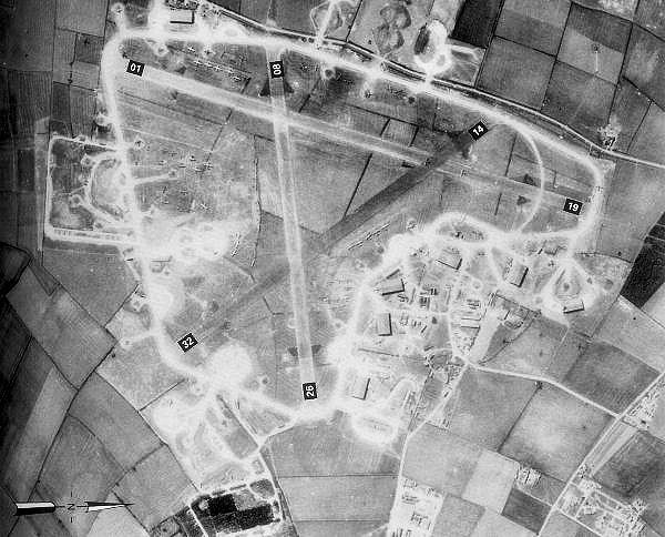
RAF Bottesford

Royal Air Force Bottesford or more simply RAF Bottesford is a former Royal Air Force station located on the Leicestershire-Lincolnshire county border,...

Belvoir Rural District

Belvoir was a rural district in Leicestershire, England from 1894 to 1935. It was formed under the Local Government Act 1894 from the part of the Grantham...

Debdale Meadow, Muston

Debdale Meadow, Muston is a 4.3-hectare (11-acre) biological Site of Special Scientific Interest north of Muston in Leicestershire.This traditionally managed...

Nearby Amenities

Located within 500m of 52.948295,-0.79267155
Bottesford
Naptan AtcoCode: 9100BOTESFD
Network: National Rail
Network Website: https://www.nationalrail.co.uk/stations/btf/
Network Wikidata: Q26334
Operator: East Midlands Railway
Public Transport: station
Railway: station
Ref Crs: BTF
Source: NPE
Wikidata: Q3985747
Wikipedia: en:Bottesford railway station
Lat/Long: 52.9447732/-0.7951793
Parking
Lat/Long: 52.9445182/-0.7950306
Bus Stop
Railway Station
Bus: yes
Naptan AtcoCode: 260000214
Naptan Bearing: E
Naptan BusStopType: CUS
Naptan CommonName: Railway Station
Naptan Indicator: opposite
Naptan Landmark: Railway Station
Naptan NaptanCode: leidmtmp
Naptan Notes: Non-Hourly - County
Naptan Street: Station Road
Naptan Verified: no
Public Transport: platform
Source: naptan_import
Lat/Long: 52.9443536/-0.7954179
Bus Stop
Station Approach
Bus: yes
Naptan AtcoCode: 260000216
Naptan Bearing: E
Naptan CommonName: Station Approach
Naptan Indicator: adj
Naptan Landmark: Railway Station
Naptan Street: Station Road
Naptan Verified: no
Public Transport: platform
Source: naptan_import
Lat/Long: 52.944456/-0.7949883
Bus Stop
Railway Station
Alt Name: Bottesford - Railway Station;Bottesford - Railway Station;Bottesford - Train Station
Bus: yes
Naptan AltCommonName: Bottesford - Railway Station;Bottesford - Train Station
Naptan AtcoCode: 260080099
Naptan Bearing: W
Naptan BusStopType: CUS
Naptan CommonName: Railway Station
Naptan Indicator: adjacent
Naptan Landmark: Railway Station
Naptan NaptanCode: leimadga
Naptan Notes: Non-Hourly - County
Naptan Street: Station Road
Naptan Verified: no
Public Transport: platform
Source: naptan_import
Lat/Long: 52.944459/-0.7952859
Railway: level_crossing
Lat/Long: 52.9452516/-0.7965667
Bottesford Millennium Beacon
Man Made: beacon
Lat/Long: 52.948137/-0.7929923
Man Made: survey_point
Lat/Long: 52.9481935/-0.7929279
Railway: level_crossing
Lat/Long: 52.94528/-0.7965242
Beacon Hill
Place: farm
Source: Bing
Lat/Long: 52.9480247/-0.792024
Beacon Hill
Natural: peak
Lat/Long: 52.9480884/-0.7929576
Bottesford
Public Transport: stop_position
Railway: stop
Train: yes
Lat/Long: 52.9441431/-0.7933482
Bottesford
Public Transport: stop_position
Railway: stop
Train: yes
Lat/Long: 52.9448669/-0.7954873
The data included in this document is from www.openstreetmap.org. The data is made available under ODbL.

Have you been to Beacon Hill?

Leave your review of Beacon Hill below (or comments, questions and feedback).