Bill Hill

Hill, Mountain in Berkshire

England

Bill Hill

Wild Flowers by the Footpath A patch of daisies by the path towards Pebblestone Copse.
Wild Flowers by the Footpath Credit: Des Blenkinsopp

Bill Hill, Berkshire, also known as Bill Hill or simply The Hill, is a prominent hill located near the town of Newbury in the county of Berkshire, England. Standing at an elevation of approximately 280 meters (919 feet), it forms part of the Berkshire Downs, a range of chalk hills that extend across the southern parts of the county.

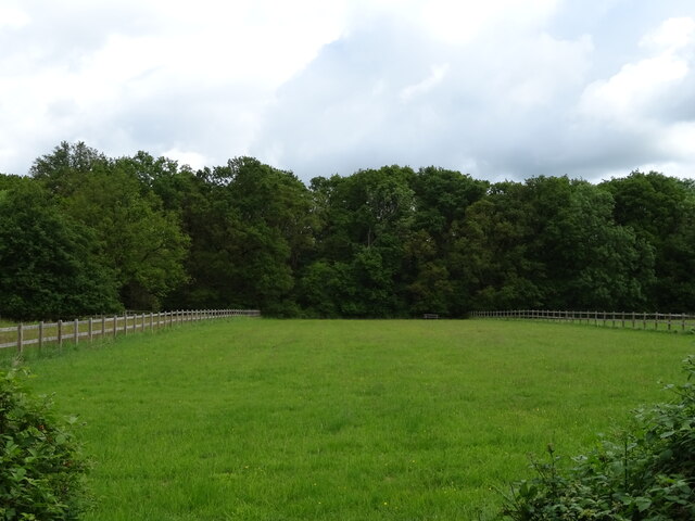
Bill Hill is a popular destination for outdoor enthusiasts due to its stunning panoramic views and diverse natural beauty. The hill is covered in lush green meadows and patches of woodland, creating a picturesque landscape that attracts hikers, walkers, and nature lovers alike.

The summit of Bill Hill offers breathtaking vistas across the surrounding countryside, with stunning vistas of the nearby Lambourn Valley and the charming village of East Garston. On clear days, it is even possible to see as far as the distant North Wessex Downs and the Marlborough Downs.

Aside from its natural beauty, Bill Hill also holds historical significance. It is believed that the hill was once an Iron Age hill fort, with some remnants of ancient earthworks and ditches still visible today. These archaeological features contribute to the hill's allure, attracting history enthusiasts and archaeology buffs.

Access to Bill Hill is relatively easy, with several footpaths and trails leading to the summit. These routes are well-maintained and offer a pleasant walking experience for visitors of all abilities. Whether it's for a leisurely stroll or a challenging hike, Bill Hill provides an excellent opportunity to immerse oneself in the tranquility of the Berkshire countryside while enjoying captivating views of the surrounding area.

If you have any feedback on the listing, please let us know in the comments section below.

Bill Hill Images

Images are sourced within 2km of 51.430422/-0.83417515 or Grid Reference SU8170. Thanks to Geograph Open Source API. All images are credited.

Wild Flowers by the Footpath A patch of daisies by the path towards Pebblestone Copse.
Wild Flowers by the Footpath
A patch of daisies by the path towards Pebblestone Copse.
Forest Road, B3034
Forest Road, B3034
Notices at the junction Pointing the way to firms at Warren Farm, a business park nearly 1 km north of here down a long service road.
Notices at the junction
Pointing the way to firms at Warren Farm, a business park nearly 1 km north of here down a long service road.
Keep Going for the Cafe Just over half way along the road to Warren Farm where a number of businesses are located. There is also a cafe serving workers and visitors.
Keep Going for the Cafe
Just over half way along the road to Warren Farm where a number of businesses are located. There is also a cafe serving workers and visitors.
Pond at Ashridge Manor Farm A secluded pond with landscaped surroundings. Probably a fish pond.
Pond at Ashridge Manor Farm
A secluded pond with landscaped surroundings. Probably a fish pond.
Another view of Ashridge Farm Pond Another view of a secluded fish pond in a woodland setting. Viewed from the nearby footpath.
Another view of Ashridge Farm Pond
Another view of a secluded fish pond in a woodland setting. Viewed from the nearby footpath.
Ashridge Manor A Victorian country house from the 1850s, now in business use.
Ashridge Manor
A Victorian country house from the 1850s, now in business use.
Houses on Forest Road
Forest Road (B3034) Towards the A321.
Forest Road (B3034)
Towards the A321.
Grazing towards Tippen's Wood
Forest Road (B3034) Towards the A321.
Forest Road (B3034)
Towards the A321.
Houses on Forest Road (B3034)
The Warren public house On Forest Road.
See <a href="https://www.geograph.org.uk/photo/7280725">SU8171 : Sign for The Warren public house</a> for sign.
The Warren public house
On Forest Road. See SU8171 : Sign for The Warren public house for sign.
The Warren public house On Forest Road.
See <a href="https://www.geograph.org.uk/photo/7280725">SU8171 : Sign for The Warren public house</a> for sign.
The Warren public house
On Forest Road. See SU8171 : Sign for The Warren public house for sign.
Sign for The Warren public house See <a href="https://www.geograph.org.uk/photo/7280720">SU8171 : The Warren public house</a> and <a href="https://www.geograph.org.uk/photo/7280722">SU8171 : The Warren public house</a> for context.
Sign for The Warren public house
Roundabout on  Forest Road (B3034)
Roundabout on Forest Road (B3034)
Forest Road (B3034) Towards Twyford.
Forest Road (B3034)
Towards Twyford.
Aspen House (flats)
Aspen House (flats)
Show me another place!

Bill Hill is located at Grid Ref: SU8170 (Lat: 51.430422, Lng: -0.83417515)

Unitary Authority: Wokingham

Police Authority: Thames Valley

What 3 Words

///retire.funded.speeds. Near Wokingham, Berkshire

Nearby Locations

Bill Hill

Related Wikis

Norreys Estate

The Norreys Estate is a housing estate, part of the Dowlesgreen area of Wokingham in the English county of Berkshire, situated just east of the town centre...

The Emmbrook School

The Emmbrook School is a co-educational secondary school located in Emmbrook, Wokingham, Berkshire, England, for students between 11 and 18 years of age...

Emmbrook, Berkshire

Emmbrook is a suburb of the town of Wokingham in the county of Berkshire, England.The suburb takes its name from the Emm Brook, a small river that is...

Holt Copse & Joel Park

Holt Copse & Joel Park is a 5.3-hectare (13-acre) Local Nature Reserve (LNR) in Wokingham in Berkshire. It is owned by Wokingham Town Council and managed...

The Holt School

The Holt School is a secondary school located on the outskirts of Wokingham, Berkshire, England, on Holt Lane. It is a girls' school and currently teaches...

Wokingham & Emmbrook F.C.

Wokingham & Emmbrook F.C. are a football club based in Wokingham, Berkshire, England. The club was formed in 1875 as Wokingham Town and adopted their current...

Billingbear

Billingbear is a hamlet in the civil parish of Binfield and a former country estate in the civil parish of Waltham St Lawrence, near Bracknell, in the...

Wokingham railway station

Wokingham railway station serves the market town of Wokingham in Berkshire, England. It is 62 miles 8 chains (62.10 mi; 99.9 km) down the line from London...

Nearby Amenities

Located within 500m of 51.430422,-0.83417515
Ashridgewood Place Home Farm
Landuse: farm
Note Retag: CS #48756035
Source: OS OpenData StreetView
Lat/Long: 51.4309622/-0.8292204
Direction: 180
Generator Method: photovoltaic
Generator Output Electricity: yes
Generator Solar Modules: 55
Generator Source: solar
Generator Type: solar_photovoltaic_panel
Location: roof
Power: generator
Lat/Long: 51.4326877/-0.8335387
Direction: 90
Generator Method: photovoltaic
Generator Output Electricity: yes
Generator Solar Modules: 66
Generator Source: solar
Generator Type: solar_photovoltaic_panel
Location: roof
Power: generator
Lat/Long: 51.4329131/-0.8335659
The Craft Shop
Shop: craft
Lat/Long: 51.4315048/-0.836877
Gardeneer
Shop: garden_centre
Lat/Long: 51.4312842/-0.8374518
Mr. Pet Supplies
Shop: pet
Lat/Long: 51.4314288/-0.8375292
Stop
Direction: backward
Lat/Long: 51.4326314/-0.8399698
Stop
Direction: forward
Lat/Long: 51.432632/-0.8401359
The data included in this document is from www.openstreetmap.org. The data is made available under ODbL.

Have you been to Bill Hill?

Leave your review of Bill Hill below (or comments, questions and feedback).