Cleveland Hill

Hill, Mountain in Nottinghamshire Bassetlaw

England

Cleveland Hill

Markham Clinton Trig Point Flush Bracket S1860
Markham Clinton Trig Point Flush Bracket S1860 Credit: thejackrustles

Cleveland Hill, located in Nottinghamshire, is a prominent geological feature that stands as a testimony to the region's rich natural heritage. Rising majestically to a height of approximately 150 meters, this hill is a popular destination for outdoor enthusiasts and nature lovers alike.

Situated on the outskirts of the village of Cleveland, the hill offers breathtaking panoramic views of the surrounding countryside. Its distinctive shape, resembling a gentle slope rather than a steep incline, makes it easily accessible for hikers and walkers of all ages and abilities.

The hill is covered in a tapestry of lush greenery, including a mix of deciduous and coniferous trees, adding to its visual appeal throughout the year. Springtime brings an explosion of vibrant wildflowers, while autumn adorns the hillside with a stunning array of golden hues.

Numerous well-marked trails crisscross the hill, providing opportunities for visitors to explore its diverse ecosystem. Wildlife enthusiasts can spot a variety of species, including birds, butterflies, and small mammals, thriving in the hill's natural habitat.

Cleveland Hill also holds historical significance, with archaeological evidence suggesting human activity in the area dating back thousands of years. It is believed that ancient settlements once dotted the hillside, leaving behind remnants of their existence.

Overall, Cleveland Hill is a captivating natural landmark that offers visitors a chance to immerse themselves in the tranquil beauty of Nottinghamshire's countryside. Whether one seeks a peaceful stroll, an adventurous hike, or a glimpse into the region's past, this hill is sure to leave a lasting impression on all who venture to its summit.

If you have any feedback on the listing, please let us know in the comments section below.

Cleveland Hill Images

Images are sourced within 2km of 53.247838/-0.91340188 or Grid Reference SK7272. Thanks to Geograph Open Source API. All images are credited.

Markham Clinton Trig Point Flush Bracket S1860
Low bridge on lane to Askham. Low rail bridge
Low bridge on lane to Askham.
Low rail bridge
Plantation Road A street in East Markham.
Plantation Road
A street in East Markham.
Church and Footpath through the churchyard. A walk through East Markham.
Church and Footpath through the churchyard.
A walk through East Markham.
A bend in the Tuxford Road Between Tuxford and East Markham.
A bend in the Tuxford Road
Between Tuxford and East Markham.
All Saints' Church in West Markham Attractive old church in West Markham.
All Saints' Church in West Markham
Attractive old church in West Markham.
Milton Mausoleum. Alongside the lane to West Markham.
Milton Mausoleum.
Alongside the lane to West Markham.
The River Maun. The River runs alongside the village of Milton.
The River Maun.
The River runs alongside the village of Milton.
Back Lane View towards Tuxford.
Back Lane
View towards Tuxford.
Bevercoates Road Looking towards Tuxford.
Bevercoates Road
Looking towards Tuxford.
A57 near Markham
A57 near Markham
A57, Broad Gate
A57, Broad Gate
A  wet  day  at  Markham  Moor  Services Exiting Starbucks onto the service road to the roundabout. The A1 beyond. The roof of Starbucks is of a Hyperbolic Paraboloid design, if you want to be even more confused look that up!!
A wet day at Markham Moor Services
Exiting Starbucks onto the service road to the roundabout. The A1 beyond. The roof of Starbucks is of a Hyperbolic Paraboloid design, if you want to be even more confused look that up!!
Markham Moor interchange, services and industry: aerial 2023 (1)
Markham Moor interchange, services and industry: aerial 2023 (2)
Recreation Ground, East Markham
Arable land
Arable land
View into the Trent valley from the higher ground near Askham In the distance, the power station on the Trent at Cottam, one of a string along the river.
View into the Trent valley from the higher ground near Askham
In the distance, the power station on the Trent at Cottam, one of a string along the river.
Show me another place!

Cleveland Hill is located at Grid Ref: SK7272 (Lat: 53.247838, Lng: -0.91340188)

Administrative County: Nottinghamshire

District: Bassetlaw

Police Authority: Nottinghamshire

What 3 Words

///fence.celebrate.exams. Near East Markham, Nottinghamshire

Related Wikis

Markham Moor

Markham Moor is a village which lies five miles south of the town of Retford in Nottinghamshire. The village is in the civil parish of West Drayton. Markham...

West Markham

West Markham or Markham Clinton is a village and civil parish 23 miles (37 km) north east of Nottingham, in the Bassetlaw district, in the county of Nottinghamshire...

All Saints' Church, West Markham

All Saints' Church is a Grade I listed parish church in the Church of England serving the parish of Markham Clinton in West Markham, Nottinghamshire....
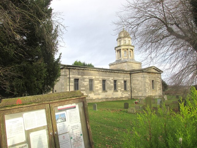
Milton Mausoleum

The Milton Mausoleum is a redundant Anglican church in the village of Milton, Nottinghamshire, England. It is recorded in the National Heritage List for...

Milton, Nottinghamshire

Milton is a hamlet in Nottinghamshire. It is part of West Markham civil parish, a short distance northwest of West Markham and southwest of Sibthorpe....

Askham, Nottinghamshire

Askham is a village and civil parish in the Bassetlaw district of Nottinghamshire, England, about six miles south-east of East Retford. According to the...

East Markham

East Markham, historically also known as Great Markham, is a small village and civil parish near Tuxford, Nottinghamshire. The population of the civil...

Church of St John the Baptist, East Markham

The Church of St. John the Baptist, East Markham is a parish church in the Church of England in East Markham, Nottinghamshire. The church is Grade I listed...

Nearby Amenities

Located within 500m of 53.247838,-0.91340188
West Markham
Place: village
Wikidata: Q3458647
Wikipedia: en:West Markham
Lat/Long: 53.244775/-0.9184985
Bus Stop
Main Street
Naptan AtcoCode: 3300BA0559
Naptan Bearing: S
Naptan CommonName: Main Street
Naptan Crossing: Bacon Lane
Naptan Indicator: S-bound
Naptan NaptanCode: ntsgamad
Naptan Notes: BW--3300BA0901
Naptan Street: Main Street
Naptan Verified: no
Source: naptan_import
Lat/Long: 53.2446145/-0.9184082
Main Street
Naptan AtcoCode: 3300BA0901
Naptan Bearing: N
Naptan BusStopType: CUS
Naptan CommonName: Main Street
Naptan Crossing: Bacon Lane
Naptan Indicator: N-bound
Naptan NaptanCode: ntsgmatg
Naptan Notes: CUS--3300BA0559
Naptan Street: Main Street
Naptan Verified: no
Source: naptan_import
Lat/Long: 53.2445523/-0.9184847
Fixme: where does this go? I don't think it goes down onto the A1
Lat/Long: 53.2479923/-0.9074985
Barrier: stile
Lat/Long: 53.2474788/-0.9162694
Post Box
Ref: NG22 69
Source: Survey
Lat/Long: 53.2449816/-0.9186298
Source: Survey
Tourism: information
Lat/Long: 53.2449383/-0.918619
Barrier: kissing_gate
Lat/Long: 53.248532/-0.9070734
Barrier: kissing_gate
Lat/Long: 53.2492096/-0.9080418
Direction: SSE
Generator Method: photovoltaic
Generator Output Electricity: yes
Generator Solar Modules: 10
Generator Source: solar
Generator Type: solar_photovoltaic_panel
Location: roof
Power: generator
Lat/Long: 53.2454733/-0.9180085
Direction: SSE
Generator Method: photovoltaic
Generator Output Electricity: yes
Generator Solar Modules: 3
Generator Source: solar
Generator Type: solar_photovoltaic_panel
Location: roof
Power: generator
Lat/Long: 53.2455079/-0.9180473
Direction: S
Generator Method: photovoltaic
Generator Output Electricity: yes
Generator Solar Modules: 24
Generator Source: solar
Generator Type: solar_photovoltaic_panel
Location: ground
Power: generator
Lat/Long: 53.2446422/-0.9186826
Direction: SSE
Generator Method: photovoltaic
Generator Output Electricity: yes
Generator Solar Modules: 10
Generator Source: solar
Generator Type: solar_photovoltaic_panel
Location: roof
Power: generator
Lat/Long: 53.244497/-0.9174785
Give Way
Direction: backward
Lat/Long: 53.246131/-0.9198263
The data included in this document is from www.openstreetmap.org. The data is made available under ODbL.

Have you been to Cleveland Hill?

Leave your review of Cleveland Hill below (or comments, questions and feedback).