Red Hill

Hill, Mountain in Nottinghamshire Newark and Sherwood

England

Red Hill

Roadway to North Laiths This is also a public footpath.
Roadway to North Laiths Credit: Jonathan Thacker

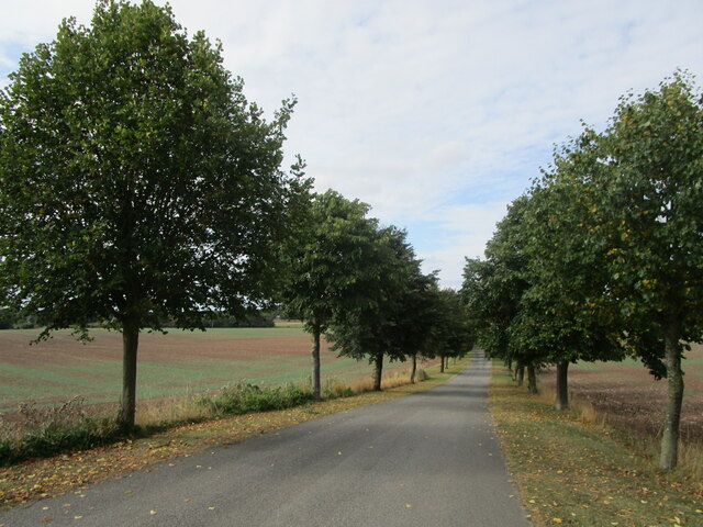
Red Hill is a prominent geographical feature located in Nottinghamshire, England. It is known for its impressive elevation and picturesque landscape, making it a popular destination for outdoor enthusiasts and nature lovers alike. Despite its name, Red Hill is not a mountain, but rather a hill that rises to an elevation of approximately 235 meters above sea level.

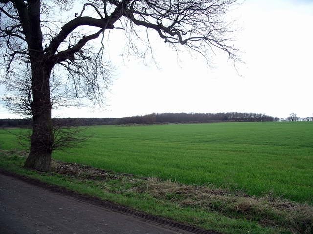
Situated in the eastern part of Nottinghamshire, Red Hill offers breathtaking panoramic views of the surrounding countryside. The hill is characterized by its gently sloping sides, covered in lush greenery and dotted with a variety of trees, including oak, beech, and birch. These trees provide a habitat for a diverse range of wildlife, making it a haven for nature enthusiasts.

The summit of Red Hill offers an excellent vantage point, allowing visitors to marvel at the stunning vistas that stretch for miles in every direction. On clear days, one can spot nearby landmarks, such as the historic Nottingham Castle and the sprawling Sherwood Forest.

Red Hill is easily accessible, with several footpaths and trails leading to its summit. These paths are well-maintained, ensuring a safe and enjoyable experience for hikers and walkers. Additionally, there are designated areas for picnicking, allowing visitors to relax and soak up the tranquil atmosphere.

Overall, Red Hill is a captivating natural landmark that offers an escape from the hustle and bustle of urban life. Whether one is seeking a peaceful stroll or a challenging hike, this picturesque hill provides an idyllic setting for outdoor exploration and appreciation of the scenic beauty that Nottinghamshire has to offer.

If you have any feedback on the listing, please let us know in the comments section below.

Red Hill Images

Images are sourced within 2km of 53.168023/-0.99230921 or Grid Reference SK6763. Thanks to Geograph Open Source API. All images are credited.

Roadway to North Laiths This is also a public footpath.
Roadway to North Laiths
This is also a public footpath.
Red Hill and Hunger Hills A new house is being built at Hunger Hills (in the centre of the picture).
Red Hill and Hunger Hills
A new house is being built at Hunger Hills (in the centre of the picture).
Roadway from North Laiths This is also a public footpath.
Roadway from North Laiths
This is also a public footpath.
The course of the Mid Nottinghamshire Joint Railway The Mid-Nottinghamshire Joint Railway opened in 1931 and this section closed in 1966. As planned the railway would have run along the spine of Nottinghamshire linking the collieries on the eastern edge of the coalfield with the various main lines. The line was never completed and only really served the colliery at Bilsthorpe (and to a lesser extent that at Ollerton). 
Here the track bed is overgrown and the bridge, which stood at the point from which this photograph was taken, has been infilled.
The course of the Mid Nottinghamshire Joint Railway
The Mid-Nottinghamshire Joint Railway opened in 1931 and this section closed in 1966. As planned the railway would have run along the spine of Nottinghamshire linking the collieries on the eastern edge of the coalfield with the various main lines. The line was never completed and only really served the colliery at Bilsthorpe (and to a lesser extent that at Ollerton). Here the track bed is overgrown and the bridge, which stood at the point from which this photograph was taken, has been infilled.
Stubble field near North Laiths
Farmhouse at North Laiths
Roadway at North Laiths The Pigeoncote <span class="nowrap"><a title="https://historicengland.org.uk/listing/the-list/list-entry/1178695" rel="nofollow ugc noopener" href="https://historicengland.org.uk/listing/the-list/list-entry/1178695">Link</a><img style="margin-left:2px;" alt="External link" title="External link - shift click to open in new window" src="https://s1.geograph.org.uk/img/external.png" width="10" height="10"/></span> is visible in the centre of the picture.
Roadway at North Laiths
The Pigeoncote LinkExternal link is visible in the centre of the picture.
Roadway and footpath from North Laiths
Footpath to Wellow near North Laiths
Stubble field near North Laiths
Entrance to a potato field The field is being inspected prior to harvesting.
Entrance to a potato field
The field is being inspected prior to harvesting.
Stubble field and New Park Wood
Farm track and footpath to Rufford
Paddocks near Rufford
Pigeoncote and kennels at North Laiths Listed Grade II <span class="nowrap"><a title="https://historicengland.org.uk/listing/the-list/list-entry/1178695" rel="nofollow ugc noopener" href="https://historicengland.org.uk/listing/the-list/list-entry/1178695">Link</a><img style="margin-left:2px;" alt="External link" title="External link - shift click to open in new window" src="https://s1.geograph.org.uk/img/external.png" width="10" height="10"/></span>
Pigeoncote and kennels at North Laiths
Listed Grade II LinkExternal link
Farm buildings at North Laiths The pigeoncote in the centre of the picture is listed <span class="nowrap"><a title="https://historicengland.org.uk/listing/the-list/list-entry/1178695" rel="nofollow ugc noopener" href="https://historicengland.org.uk/listing/the-list/list-entry/1178695">Link</a><img style="margin-left:2px;" alt="External link" title="External link - shift click to open in new window" src="https://s1.geograph.org.uk/img/external.png" width="10" height="10"/></span>
Farm buildings at North Laiths
The pigeoncote in the centre of the picture is listed LinkExternal link
Gallow Hole Dyke
Gallow Hole Dyke
Show me another place!

Red Hill is located at Grid Ref: SK6763 (Lat: 53.168023, Lng: -0.99230921)

Administrative County: Nottinghamshire

District: Newark and Sherwood

Police Authority: Nottinghamshire

What 3 Words

///hourglass.starred.superbly. Near Boughton, Nottinghamshire

Nearby Locations

Red Hill Lound Wood

Related Wikis

Eakring

Eakring is a village and civil parish in the Newark and Sherwood district of Nottinghamshire, England. Its population at the 2011 Census was 419. There...

Ompton

Ompton is a village in Nottinghamshire, England, three miles south-east of Ollerton. It is in the civil parish of Ompton, but for census purposes its population...

St Swithin's Church, Wellow

St Swithin's Church, Wellow is a Grade II* listed Church of England parish in the Diocese of Southwell and Nottingham in Wellow, Nottinghamshire. ��2...

Wellow, Nottinghamshire

Wellow is a village in Nottinghamshire, England. According to the 2001 census it had a population of 444, increasing to 470 at the 2011 census.It has a...

Jordan's Castle, Wellow

Jordan's Castle is a former fortified manor house site and possible ringwork castle, located near Wellow, Nottinghamshire, England. Originally owned by...

Cratley

Cratley is a lost village in Nottinghamshire, England. It may have been located close to North Laithes Farm at Kneesall although an alternative site east...

St Bartholomew's Church, Kneesall

St Bartholomew’s Church, Kneesall is a Grade I listed Church of England parish in the Diocese of Southwell and Nottingham in Kneesall. == History == The...

Kneesall

Kneesall is a village and civil parish in the East Midlands of England in the county of Nottinghamshire. The population of the civil parish at the 2011...

Have you been to Red Hill?

Leave your review of Red Hill below (or comments, questions and feedback).