Twin Hill

Hill, Mountain in Nottinghamshire Gedling

England

Twin Hill

Robin Hood Way crossing Swinecotte Dale The road is the main vehicle access route for Newstead Abbey.
Robin Hood Way crossing Swinecotte Dale Credit: Bill Boaden

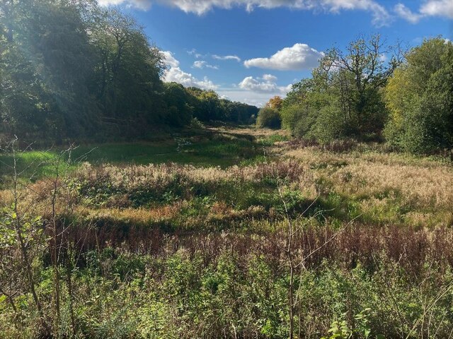
Twin Hill, located in Nottinghamshire, is a picturesque hill that offers breathtaking views and a serene atmosphere to its visitors. Situated in the heart of the county, Twin Hill is one of the most prominent natural landmarks in the region.

Rising to an elevation of approximately 300 meters, Twin Hill is not only a stunning sight but also provides a challenging hiking experience for outdoor enthusiasts. The hill is a part of the wider Sherwood Forest area, known for its rich history and association with the legendary Robin Hood.

The hill gets its name from the two distinct peaks that can be seen from a distance, resembling twin summits. These peaks are covered in lush greenery, which adds to the hill's charm and natural beauty.

Twin Hill is a popular destination for nature lovers, hikers, and photographers alike. Its well-maintained trails offer a variety of routes, ranging from easy walks to more demanding hikes, catering to different skill levels. The hill's diverse flora and fauna attract wildlife enthusiasts, who can spot various bird species, small mammals, and even deer in the surrounding woodlands.

Visitors to Twin Hill can enjoy panoramic views of the surrounding countryside, including the rolling hills and meandering rivers that characterize Nottinghamshire's landscape. The hilltop also provides an ideal spot for picnics, allowing visitors to relax and soak in the tranquil ambiance.

Overall, Twin Hill in Nottinghamshire offers a captivating natural setting, making it a must-visit destination for those seeking to connect with nature and enjoy the beauty of the English countryside.

If you have any feedback on the listing, please let us know in the comments section below.

Twin Hill Images

Images are sourced within 2km of 53.095234/-1.1714687 or Grid Reference SK5555. Thanks to Geograph Open Source API. All images are credited.

Robin Hood Way crossing Swinecotte Dale The road is the main vehicle access route for Newstead Abbey.
Robin Hood Way crossing Swinecotte Dale
The road is the main vehicle access route for Newstead Abbey.
Robin Hood Way in Newstead Park Passing through woodland on the edge of the park. The Robin Hood Way is a long-distance footpath of 104 miles, but it takes a very circuitous route within Nottinghamshire.
Robin Hood Way in Newstead Park
Passing through woodland on the edge of the park. The Robin Hood Way is a long-distance footpath of 104 miles, but it takes a very circuitous route within Nottinghamshire.
B6139 Road at Normanshill Wood The road splits this wood in two - with Little Normanshill Road to the right. This photo is taken from a spot close near the marked car park.
B6139 Road at Normanshill Wood
The road splits this wood in two - with Little Normanshill Road to the right. This photo is taken from a spot close near the marked car park.
A Debated Area of Thieves Wood For those who are interested in the unexplained - this site (and this part of the wood specifically) is associated with the 'Thunderbolt Incident' which occurred on the night of 12th November 1987.
A Debated Area of Thieves Wood
For those who are interested in the unexplained - this site (and this part of the wood specifically) is associated with the 'Thunderbolt Incident' which occurred on the night of 12th November 1987.
Scene at Brackenwood Home of Nottingham Sun Club.
Scene at Brackenwood
Home of Nottingham Sun Club.
A small chalet at Brackenwood The grounds of Nottingham Sun Club.
A small chalet at Brackenwood
The grounds of Nottingham Sun Club.
Entrance to Harlow Academy
Portland College Portland College provides educational, social and employmnet support for people with disabilities.
Portland College
Portland College provides educational, social and employmnet support for people with disabilities.
The Robin Hood Way near Friar Tuck's Well The trail cuts across the south west corner of this grid square here.
The Robin Hood Way near Friar Tuck's Well
The trail cuts across the south west corner of this grid square here.
Lake near Friar Tuck's Well in Fountain Dale Robin Hood tales and place name references abound across Nottinghamshire, Derbyshire and South Yorkshire, but you get a genuinely authentic sense of the legend in this particular valley.
Lake near Friar Tuck's Well in Fountain Dale
Robin Hood tales and place name references abound across Nottinghamshire, Derbyshire and South Yorkshire, but you get a genuinely authentic sense of the legend in this particular valley.
Pond in Fountain Dale
The Robin Hood Way Pictured at the eastern periphery of the square at its junction with an unofficial path.
The Robin Hood Way
Pictured at the eastern periphery of the square at its junction with an unofficial path.
Bridle Path in Harlow Wood This path follows the fringe of the woodland here with fields to the right.
Bridle Path in Harlow Wood
This path follows the fringe of the woodland here with fields to the right.
Dryad's saddle fungus The largest capped mushroom in the UK. Also known as pheasant's back mushroom, for an obvious reason
Dryad's saddle fungus
The largest capped mushroom in the UK. Also known as pheasant's back mushroom, for an obvious reason
Morning sun through an oak tree On the grounds of Nottingham Sun Club.
Morning sun through an oak tree
On the grounds of Nottingham Sun Club.
Swinton Rise Ravenshead Primary School on the right.
Swinton Rise
Ravenshead Primary School on the right.
The Little John Inn
The Little John Inn
The sign of The Little John Inn See <a href="https://www.geograph.org.uk/photo/7584171">SK5655 : The Little John Inn</a>
The sign of The Little John Inn
Show me another place!

Twin Hill is located at Grid Ref: SK5555 (Lat: 53.095234, Lng: -1.1714687)

Administrative County: Nottinghamshire

District: Gedling

Police Authority: Nottinghamshire

What 3 Words

///axed.dawn.shirts. Near Ravenshead, Nottinghamshire

Nearby Locations

Twin Hill

Related Wikis

Ravenshead

Ravenshead is a large village and civil parish in the Gedling district of Nottinghamshire, England. It borders Papplewick, Newstead Abbey and Blidworth...
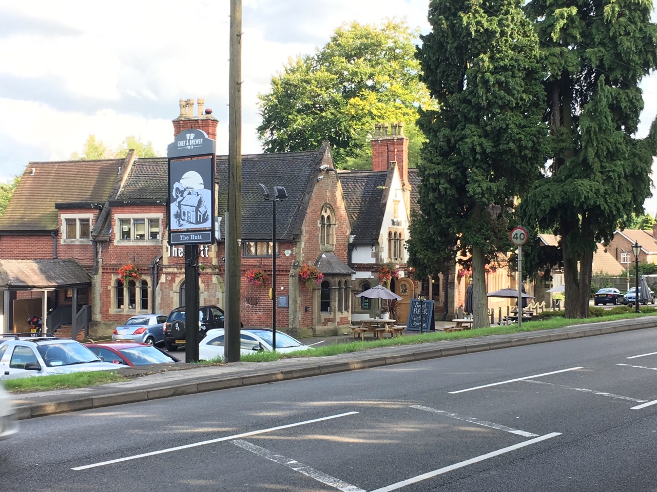
The Hutt

The Hutt is a public house located in the village of Ravenshead in Nottinghamshire, opposite Newstead Abbey. The pub was built on the site of The Royal...

Portland College

Portland College is an education establishment near Ravenshead, Nottinghamshire, England. It is situated in 20 acres (81,000 m2) of Sherwood Forest approximately...

Skegby Rural District

Skegby was a rural district in Nottinghamshire, England from 1894 to 1935. It was created under the Local Government Act 1894 based on that part of the...

Lindhurst

Lindhurst is a civil parish and hamlet in the Newark and Sherwood district, is 120 miles (190 km) north west of London, 11 miles (18 km) north of Nottingham...

Newstead Abbey

Newstead Abbey, in Nottinghamshire, England, was formerly an Augustinian priory. Converted to a domestic home following the Dissolution of the Monasteries...
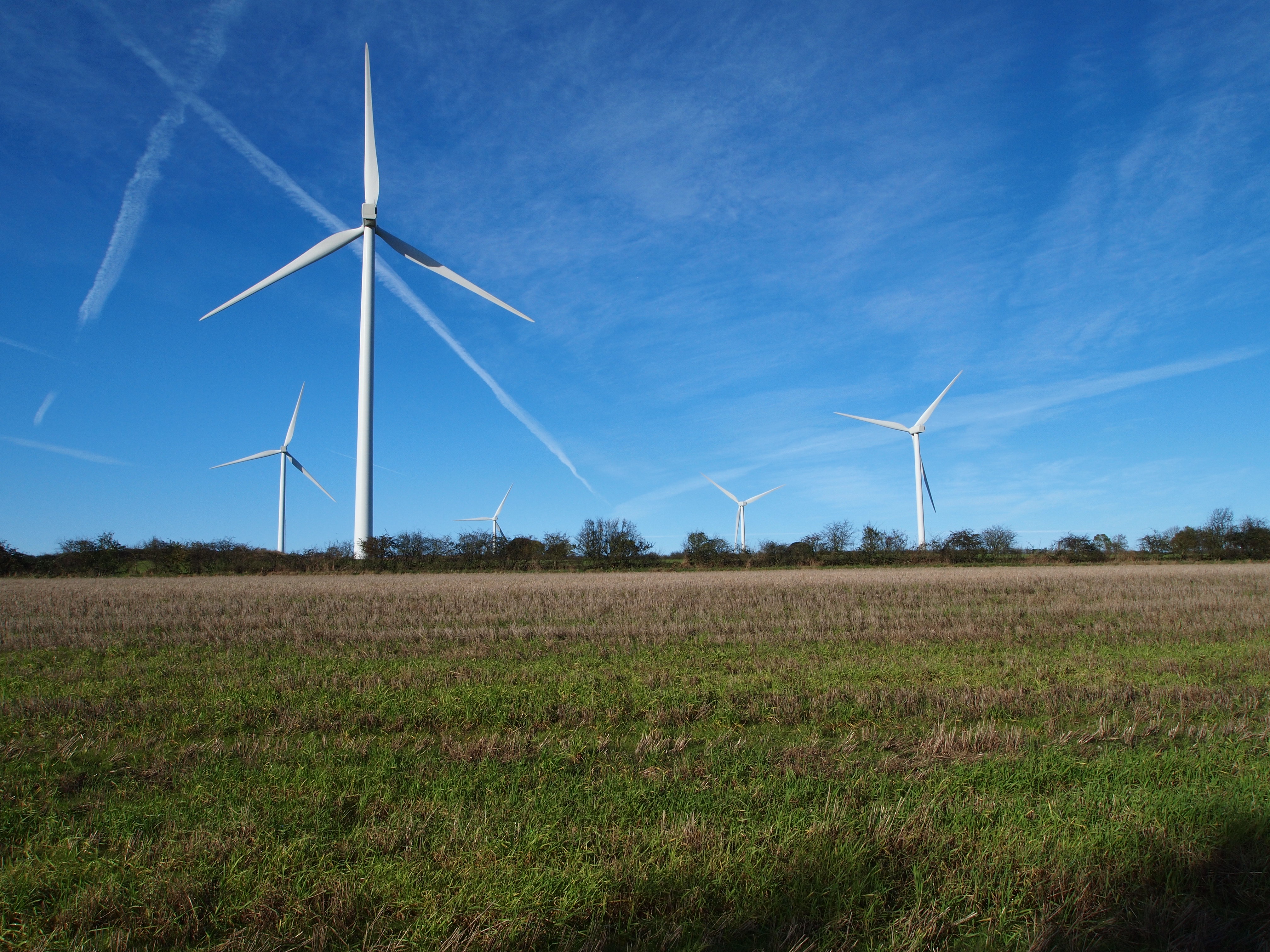
Lindhurst Wind Farm

Lindhurst Wind Farm is a power-producing wind farm in Lindhurst parish near Mansfield, England. Built for Npower Renewables, it produces electricity from...

Church of St Mary of the Purification, Blidworth

The Church of St Mary of the Purification is a parish church in the Church of England in Blidworth, Nottinghamshire, dating from the 15th century. It is...

Nearby Amenities

Located within 500m of 53.095234,-1.1714687
Grit Bin
Lat/Long: 53.0920664/-1.1670202
Post Box
Brand: Royal Mail
Brand Wikidata: Q638098
Brand Wikipedia: en:Royal Mail
Collection Times: Mo-Fr 09:00, Sa 07:00
Operator: Royal Mail
Operator Wikidata: Q638098
Post Box Type: lamp
Ref: NG15 37D
Royal Cypher: EIIR
Royal Cypher Wikidata: Q33102113
Lat/Long: 53.0920565/-1.1696079
Telephone
Booth: K6
Covered: booth
Man Made: telephone_box
Lat/Long: 53.0920497/-1.1697112
Bus Stop
Beech Avenue
Bench: yes
Bus: yes
Naptan AtcoCode: 3300GE0093
Naptan Bearing: E
Naptan CommonName: Beech Avenue
Naptan Crossing: Beech Avenue
Naptan Indicator: adj
Naptan NaptanCode: ntsapjwt
Naptan Notes: none
Naptan PlusbusZoneRef: MFLDTWN
Naptan Street: Main Road
Naptan Verified: yes
Public Transport: platform
Route Ref: 141
Shelter: yes
Source: naptan_import
Tactile Paving: no
Lat/Long: 53.0920528/-1.1696587
Bus Stop
Beech Avenue
Bench: no
Bus: yes
Naptan AtcoCode: 3300GE0106
Naptan Bearing: W
Naptan CommonName: Beech Avenue
Naptan Crossing: Beech Avenue
Naptan Indicator: opp
Naptan NaptanCode: ntsapwag
Naptan Notes: none
Naptan PlusbusZoneRef: MFLDTWN
Naptan Street: Main Road
Naptan Verified: yes
Public Transport: platform
Route Ref: 141
Shelter: no
Source: naptan_import
Tactile Paving: no
Lat/Long: 53.0919161/-1.1702057
Bus Stop
Ricket Lane
Bus: yes
Naptan AtcoCode: 3300GE0166
Naptan Bearing: S
Naptan CommonName: Ricket Lane
Naptan Crossing: Ricket Lane
Naptan Indicator: adj
Naptan NaptanCode: ntsawpag
Naptan Notes: BW
Naptan PlusbusZoneRef: MFLDTWN
Naptan Street: Mansfield Road
Naptan Verified: no
Public Transport: platform
Source: naptan_import
Lat/Long: 53.0964788/-1.177363
Ricket Lane
Naptan AtcoCode: 3300GE0726
Naptan Bearing: N
Naptan BusStopType: CUS
Naptan CommonName: Ricket Lane
Naptan Crossing: Ricket Lane
Naptan Indicator: opp
Naptan NaptanCode: ntsgjdwg
Naptan Notes: CUS--3300GE0166
Naptan PlusbusZoneRef: MFLDTWN
Naptan Street: Mansfield Road
Naptan Verified: no
Source: naptan_import
Lat/Long: 53.0963367/-1.1776476
Restaurant
Larch Farm
Addr Housenumber: 2
Addr Postcode: NG15 9HA
Addr Street: Mansfield Road
Fhrs Id: 457386
Opening Hours: Su 12:00-22:30; Mo 12:00-21:00; Tu,We 09:30-21:00; Th-Sa 09:30-22:00
Source: survey
Lat/Long: 53.0925035/-1.1772281
Parking
Parking: layby
Lat/Long: 53.0967656/-1.1730431
Parking
Parking: layby
Lat/Long: 53.096585/-1.1742555
Turning Loop
Lat/Long: 53.0929854/-1.1753951
Generator Method: photovoltaic
Generator Output Electricity: yes
Generator Source: solar
Generator Type: solar_photovoltaic_panel
Location: roof
Power: generator
Lat/Long: 53.0911876/-1.1737015
Generator Method: photovoltaic
Generator Output Electricity: yes
Generator Source: solar
Generator Type: solar_photovoltaic_panel
Location: roof
Power: generator
Lat/Long: 53.0911831/-1.1736164
Generator Method: photovoltaic
Generator Output Electricity: yes
Generator Source: solar
Generator Type: solar_photovoltaic_panel
Location: roof
Power: generator
Lat/Long: 53.0912266/-1.1736445
Generator Method: photovoltaic
Generator Output Electricity: yes
Generator Source: solar
Generator Type: solar_photovoltaic_panel
Location: roof
Power: generator
Lat/Long: 53.0912056/-1.1735788
Generator Method: photovoltaic
Generator Output Electricity: yes
Generator Source: solar
Generator Type: solar_photovoltaic_panel
Location: roof
Power: generator
Lat/Long: 53.0921697/-1.1707337
Generator Method: photovoltaic
Generator Output Electricity: yes
Generator Source: solar
Generator Type: solar_photovoltaic_panel
Location: roof
Power: generator
Lat/Long: 53.0925338/-1.172286
Bench
Backrest: yes
Lat/Long: 53.0916833/-1.1719738
Location: outdoor
Power: substation
Lat/Long: 53.0917424/-1.1730975
Waste Basket
Waste: dog_excrement
Lat/Long: 53.0916396/-1.1719007
Give Way
Direction: backward
Lat/Long: 53.0917569/-1.1718895
Give Way
Direction: backward
Lat/Long: 53.0917031/-1.172192
The data included in this document is from www.openstreetmap.org. The data is made available under ODbL.

Have you been to Twin Hill?

Leave your review of Twin Hill below (or comments, questions and feedback).