Castle Hill

Hill, Mountain in Leicestershire Hinckley and Bosworth

England

Castle Hill

Farmland along Groby Road, Anstey
Farmland along Groby Road, Anstey Credit: Mat Fascione

Castle Hill is a prominent landmark located in Leicestershire, England. Despite its name, it is not a castle in the traditional sense, but rather a hill that offers picturesque views of the surrounding countryside. Situated near the village of Kirby Muxloe, Castle Hill is known for its historical significance and natural beauty.

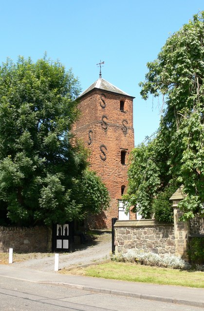
Rising to an elevation of approximately 180 meters (590 feet), Castle Hill stands as a testament to the region's rich history. The hill features the remnants of a medieval castle, which was constructed in the 15th century by Lord Hastings. The castle was intended to serve as a fortified manor house, but its construction was never fully completed, resulting in an incomplete structure. Today, only a few sections of the castle's outer walls and moat remain, providing visitors with a glimpse into the past.

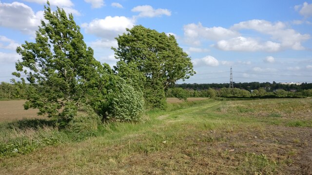
Aside from its historical significance, Castle Hill is also cherished for its stunning views. From the summit, visitors can enjoy sweeping panoramas of the Leicestershire countryside, including rolling hills, lush greenery, and charming villages. The hill is a popular destination for outdoor enthusiasts and nature lovers, who can explore the surrounding area through various walking and cycling trails.

Castle Hill is easily accessible and offers ample parking facilities for visitors. It provides a peaceful and tranquil setting, making it an ideal spot for picnics, photography, and relaxation. With its historical allure and natural beauty, Castle Hill is a must-visit destination for both locals and tourists seeking a taste of Leicestershire's past and its scenic landscapes.

If you have any feedback on the listing, please let us know in the comments section below.

Castle Hill Images

Images are sourced within 2km of 52.665581/-1.2240054 or Grid Reference SK5207. Thanks to Geograph Open Source API. All images are credited.

Farmland along Groby Road, Anstey
All Saints' church, Newtown Linford A predominantly late medieval church <span class="nowrap"><a title="https://historicengland.org.uk/listing/the-list/list-entry/1074679?section=official-list-entry" rel="nofollow ugc noopener" href="https://historicengland.org.uk/listing/the-list/list-entry/1074679?section=official-list-entry">Link</a><img style="margin-left:2px;" alt="External link" title="External link - shift click to open in new window" src="https://s1.geograph.org.uk/img/external.png" width="10" height="10"/></span>
All Saints' church, Newtown Linford
A predominantly late medieval church LinkExternal link
Lychgate, Newtown Linford
Police Box, Newtown Linford Dates from about 1931 but only on this site since 1952. One of only two remaining police boxes in Leicestershire <span class="nowrap"><a title="https://historicengland.org.uk/listing/the-list/list-entry/1475527?section=official-list-entry" rel="nofollow ugc noopener" href="https://historicengland.org.uk/listing/the-list/list-entry/1475527?section=official-list-entry">Link</a><img style="margin-left:2px;" alt="External link" title="External link - shift click to open in new window" src="https://s1.geograph.org.uk/img/external.png" width="10" height="10"/></span>
Police Box, Newtown Linford
Dates from about 1931 but only on this site since 1952. One of only two remaining police boxes in Leicestershire LinkExternal link
The A50 heading north-west out of Leicester Good, wide cycle paths on a busy dual carriageway
The A50 heading north-west out of Leicester
Good, wide cycle paths on a busy dual carriageway
Glenfield Millennium Green Well maintained, popular local amenity <span class="nowrap"><a title="https://glenfieldmillenniumgreen.weebly.com/" rel="nofollow ugc noopener" href="https://glenfieldmillenniumgreen.weebly.com/">Link</a><img style="margin-left:2px;" alt="External link" title="External link - shift click to open in new window" src="https://s1.geograph.org.uk/img/external.png" width="10" height="10"/></span>
Glenfield Millennium Green
Well maintained, popular local amenity LinkExternal link
Pedestrian and cycle path on Leicester Road about to cross the A46 I can't find any information about 'Route 2'
Pedestrian and cycle path on Leicester Road about to cross the A46
I can't find any information about 'Route 2'
Footbridge over the A46 Connecting Groby to Glenfield
Footbridge over the A46
Connecting Groby to Glenfield
Former track bed of the Groby Mineral Line The line opened in 1832, and carried Charnwood  granite gravel and blocks to canal wharves in  Leicester <span class="nowrap"><a title="http://www.groby.org.uk/the-groby-granite-railway/" rel="nofollow ugc noopener" href="http://www.groby.org.uk/the-groby-granite-railway/">Link</a><img style="margin-left:2px;" alt="External link" title="External link - shift click to open in new window" src="https://s1.geograph.org.uk/img/external.png" width="10" height="10"/></span>
Former track bed of the Groby Mineral Line
The line opened in 1832, and carried Charnwood granite gravel and blocks to canal wharves in Leicester LinkExternal link
Groby Cemetery, Ratby Road, Leicester Well maintained. Regulations at <span class="nowrap"><a title="http://groby.com/userfiles/files/Groby%20Village%20Cemetery%20Guidelines%20v%2010%202012.pdf" rel="nofollow ugc noopener" href="http://groby.com/userfiles/files/Groby%20Village%20Cemetery%20Guidelines%20v%2010%202012.pdf">Link</a><img style="margin-left:2px;" alt="External link" title="External link - shift click to open in new window" src="https://s1.geograph.org.uk/img/external.png" width="10" height="10"/></span>
Groby Cemetery, Ratby Road, Leicester
Well maintained. Regulations at LinkExternal link
The end of Woodlands Drive, Groby A path between the houses, on the right, leads to Martinshaw Wood (behind), part of the National Forest, and links with the National Forest Way
The end of Woodlands Drive, Groby
A path between the houses, on the right, leads to Martinshaw Wood (behind), part of the National Forest, and links with the National Forest Way
The National Forest Way leading into Martinshaw Wood [Abridged from: <span class="nowrap"><a title="https://www.nationalforest.org/about/our-history" rel="nofollow ugc noopener" href="https://www.nationalforest.org/about/our-history">Link</a><img style="margin-left:2px;" alt="External link" title="External link - shift click to open in new window" src="https://s1.geograph.org.uk/img/external.png" width="10" height="10"/></span>]:
In 1987 the Countryside Commission held a competition to select the location for what would be the first forest to be created at scale in England for one thousand years. The area chosen was called the Needwood-Charnwood bid. It spans across parts of Derbyshire, Leicestershire and Staffordshire, an area with a legacy of coal mining and heavy industry, and aims to link the two ancient Forests of Charnwood and Needwood. Substantial new woodland planting, and trees in towns and villages will create a new heavily wooded landscape covering 200 square miles of the Midlands. 8.7 million trees have been planted to date [2019], and it is recognised as one of the most ambitious and imaginative regeneration projects in the country. For a map see <span class="nowrap"><a title="https://www.nationalforest.org/sites/default/files/components/downloads/files/National%20Forest%20Boundary%20Map.pdf" rel="nofollow ugc noopener" href="https://www.nationalforest.org/sites/default/files/components/downloads/files/National%20Forest%20Boundary%20Map.pdf">Link</a><img style="margin-left:2px;" alt="External link" title="External link - shift click to open in new window" src="https://s1.geograph.org.uk/img/external.png" width="10" height="10"/></span>
The National Forest Way leading into Martinshaw Wood
[Abridged from: LinkExternal link]: In 1987 the Countryside Commission held a competition to select the location for what would be the first forest to be created at scale in England for one thousand years. The area chosen was called the Needwood-Charnwood bid. It spans across parts of Derbyshire, Leicestershire and Staffordshire, an area with a legacy of coal mining and heavy industry, and aims to link the two ancient Forests of Charnwood and Needwood. Substantial new woodland planting, and trees in towns and villages will create a new heavily wooded landscape covering 200 square miles of the Midlands. 8.7 million trees have been planted to date [2019], and it is recognised as one of the most ambitious and imaginative regeneration projects in the country. For a map see LinkExternal link
The Old Hall, Groby Listed Grade II, from the 15th century. Home to two queens of England: Elizabeth Woodville and Lady Jane Grey. <span class="nowrap"><a title="https://en.wikipedia.org/wiki/Groby_Old_Hall" rel="nofollow ugc noopener" href="https://en.wikipedia.org/wiki/Groby_Old_Hall">Link</a><img style="margin-left:2px;" alt="External link" title="External link - shift click to open in new window" src="https://s1.geograph.org.uk/img/external.png" width="10" height="10"/></span>
The Old Hall, Groby
Listed Grade II, from the 15th century. Home to two queens of England: Elizabeth Woodville and Lady Jane Grey. LinkExternal link
Church of St Philip and St James, Groby "Built in 1840 by the Earl of Stamford owing to the distance to Ratby Church from his home in Bradgate House, and ‘to the foulness of the way there’" <span class="nowrap"><a title="http://www.groby.org.uk/a-few-facts-about-st-philip-st-james-church/" rel="nofollow ugc noopener" href="http://www.groby.org.uk/a-few-facts-about-st-philip-st-james-church/">Link</a><img style="margin-left:2px;" alt="External link" title="External link - shift click to open in new window" src="https://s1.geograph.org.uk/img/external.png" width="10" height="10"/></span>
Church of St Philip and St James, Groby
"Built in 1840 by the Earl of Stamford owing to the distance to Ratby Church from his home in Bradgate House, and ‘to the foulness of the way there’" LinkExternal link
Groby Pool (SSSI) Said to be the largest natural expanse of water in Leicestershire, though opinions differ as to how natural the pool is <span class="nowrap"><a title="http://www.groby.org.uk/the-history-of-groby-pool/" rel="nofollow ugc noopener" href="http://www.groby.org.uk/the-history-of-groby-pool/">Link</a><img style="margin-left:2px;" alt="External link" title="External link - shift click to open in new window" src="https://s1.geograph.org.uk/img/external.png" width="10" height="10"/></span>
Groby Pool (SSSI)
Said to be the largest natural expanse of water in Leicestershire, though opinions differ as to how natural the pool is LinkExternal link
Exit from the churchyard of St Philip and St James, Groby Beyond the gate is the Old Cottage (no. 30 Markfield Road), a Listed Grade II cottage from the 16th century <span class="nowrap"><a title="https://historicengland.org.uk/listing/the-list/list-entry/1361385?section=official-list-entry" rel="nofollow ugc noopener" href="https://historicengland.org.uk/listing/the-list/list-entry/1361385?section=official-list-entry">Link</a><img style="margin-left:2px;" alt="External link" title="External link - shift click to open in new window" src="https://s1.geograph.org.uk/img/external.png" width="10" height="10"/></span>
Exit from the churchyard of St Philip and St James, Groby
Beyond the gate is the Old Cottage (no. 30 Markfield Road), a Listed Grade II cottage from the 16th century LinkExternal link
Footpath north of Groby Pool The path runs north-east from Newtown Linford Lane into the quarried Precambrian terrain of Charnwood
Footpath north of Groby Pool
The path runs north-east from Newtown Linford Lane into the quarried Precambrian terrain of Charnwood
Track carrying footpath to Anstey
Show me another place!

Castle Hill is located at Grid Ref: SK5207 (Lat: 52.665581, Lng: -1.2240054)

Administrative County: Leicestershire

District: Hinckley and Bosworth

Police Authority: Leicestershire

What 3 Words

///racks.gladiators.mimic. Near Ratby, Leicestershire

Nearby Locations

Castle Hill Groby

Related Wikis

Groby Castle

Groby Castle is situated in the large village of Groby to the north-west of the city of Leicester, England. == History == After the Norman Conquest, the...

Groby Old Hall

Groby Old Hall is partly a 15th-century brick-built manor house and grade II* listed building located very near the site of Groby Castle in the village...

Groby Pool and Woods

Groby Pool and Woods is a 29 hectare biological Site of Special Scientific Interest north of Groby in Leicestershire.Groby Pool is the largest natural...

Sheet Hedges Wood

Sheet Hedges Wood is in the parish of Newtown Linford, and lies some 1-mile (1.6 km) north of Groby, in Leicestershire, UK. The site is made up of two...

Groby

Groby (pronounced "GROO-bee" ) is a village in the Hinckley and Bosworth borough Leicestershire, England. It is to the north west of Leicester. The population...

Brookvale Groby Learning Campus

Brookvale Groby Learning Campus is a coeducational secondary school and sixth form located in Groby in the English county of Leicestershire.The school...

Brookvale High School

Brookvale High School, opened 1976, was a mixed middle school in the village of Groby in Leicestershire, England, providing education for students aged...

Anstey, Leicestershire

Anstey is a large village in Leicestershire, England, located north west of Leicester in the borough of Charnwood. Its population was 6,528 at the 2011...

Nearby Amenities

Located within 500m of 52.665581,-1.2240054
Motorway Junction
Lat/Long: 52.663663/-1.2229886
Pub
Stamford Arms
Real Ale: yes
Lat/Long: 52.6628783/-1.2263562
Bus Stop
Pymm Ley Lane
Bus: yes
Naptan AtcoCode: 260010702
Naptan Bearing: NW
Naptan CommonName: Pymm Ley Lane
Naptan Indicator: adjacent
Naptan Landmark: Pymm Ley Lane
Naptan NaptanCode: leiampjd
Naptan Notes: Hourly - County
Naptan Street: Leicester Road
Naptan Verified: no
Public Transport: platform
Shelter: yes
Source: naptan_import
Tactile Paving: no
Lat/Long: 52.6621455/-1.223067
Bus Stop
Stamford Arms
Alt Name: Groby - Leicester Road
Bus: yes
Naptan AltCommonName: Groby - Leicester Road
Naptan AtcoCode: 260010703
Naptan Bearing: NW
Naptan CommonName: Stamford Arms
Naptan Indicator: outside
Naptan Landmark: Stamford Arms
Naptan NaptanCode: leiamtga
Naptan Notes: Hourly - County
Naptan Street: Leicester Road
Naptan Verified: no
Public Transport: platform
Shelter: no
Source: naptan_import
Lat/Long: 52.6629384/-1.2260989
Bus Stop
Stamford Arms
Alt Name: Groby - Leicester Road
Bus: yes
Naptan AltCommonName: Groby - Leicester Road
Naptan AtcoCode: 260010704
Naptan Bearing: SE
Naptan CommonName: Stamford Arms
Naptan Indicator: opposite
Naptan Landmark: Stamford Arms
Naptan NaptanCode: leiadpwm
Naptan Notes: Hourly - County
Naptan Street: Leicester Road
Naptan Verified: no
Public Transport: platform
Shelter: yes
Source: naptan_import
Lat/Long: 52.6630082/-1.2257724
Bus Stop
Pymm Ley Lane
Bus: yes
Naptan AtcoCode: 260010705
Naptan Bearing: SE
Naptan CommonName: Pymm Ley Lane
Naptan Indicator: opposite
Naptan Landmark: Pymm Ley Lane
Naptan NaptanCode: leiamtgj
Naptan Notes: Hourly - County
Naptan Street: Leicester Road
Naptan Verified: no
Public Transport: platform
Shelter: yes
Source: naptan_import
Tactile Paving: no
Lat/Long: 52.6624743/-1.2238596
Wilsons & Sons Newsagents
Shop: newsagent
Lat/Long: 52.6625094/-1.2275397
Mark Jarvis Racing
Shop: bookmaker
Lat/Long: 52.6625647/-1.2274763
Shop: vacant
Lat/Long: 52.662471/-1.2275861
Pharmacy
Well Pharmacy
Brand: Well Pharmacy
Brand Wikidata: Q7726524
Brand Wikipedia: en:Well Pharmacy
Healthcare: pharmacy
Website: https://finder.well.co.uk/store/groby-ratby-road
Lat/Long: 52.6625411/-1.2272383
Fast Food
Groby Chinese Takeaway
Cuisine: chinese
Lat/Long: 52.6625789/-1.2271696
Pricegate
Shop: variety_store
Lat/Long: 52.662833/-1.2269397
Deli in Groby
Shop: deli
Lat/Long: 52.6629933/-1.2266646
Groby Butchers
Shop: butcher
Lat/Long: 52.663121/-1.2262951
Hamson & Sons
Office: estate_agent
Lat/Long: 52.6625203/-1.2267957
Flint
Shop: gift
Lat/Long: 52.6624747/-1.2268408
Cathy Stephens Jewelery
Shop: jewelry
Lat/Long: 52.6623756/-1.226901
Generator Method: photovoltaic
Generator Output Electricity: yes
Generator Source: solar
Generator Type: solar_photovoltaic_panel
Location: roof
Power: generator
Lat/Long: 52.6616192/-1.2210999
Generator Method: photovoltaic
Generator Output Electricity: yes
Generator Source: solar
Generator Type: solar_photovoltaic_panel
Location: roof
Power: generator
Lat/Long: 52.6621805/-1.2255255
Generator Method: photovoltaic
Generator Output Electricity: yes
Generator Source: solar
Generator Type: solar_photovoltaic_panel
Location: roof
Power: generator
Lat/Long: 52.6616745/-1.2245251
Board Type: cycling
Information: board
Operator: Leicester City Council
Tourism: information
Lat/Long: 52.663158/-1.226561
The data included in this document is from www.openstreetmap.org. The data is made available under ODbL.

Have you been to Castle Hill?

Leave your review of Castle Hill below (or comments, questions and feedback).