South Ward of Reafirth

Hill, Mountain in Shetland

Scotland

South Ward of Reafirth

Otterswick: Burn of the Mires of Queyintiptins The course of this, surely one of the longest named streams, can be seen running across the picture left-to-right and then coming towards us into the North Burn of Otterswick, whose northern bank is more prominent across the bottom of the picture.
Otterswick: Burn of the Mires of Queyintiptins Credit: Chris Downer

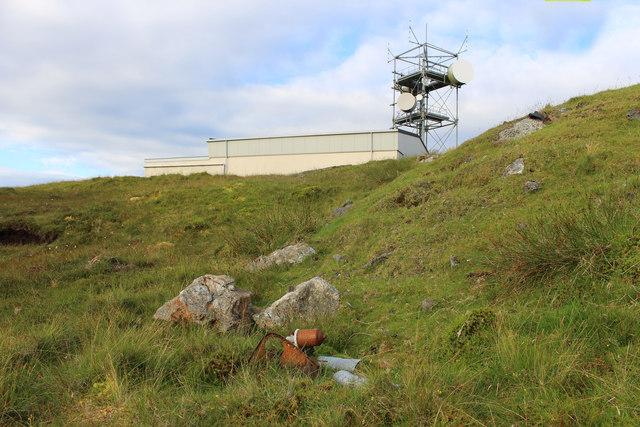
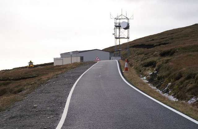
The South Ward of Reafirth, located in the Shetland Islands, Scotland, is a prominent hill/mountain that stands as a striking feature of the local landscape. Rising to an elevation of approximately 320 meters (1,050 feet), the South Ward of Reafirth offers commanding views of the surrounding area.

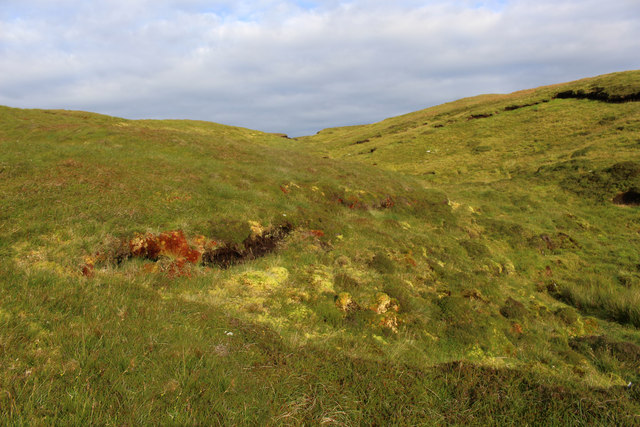
The South Ward of Reafirth is characterized by its distinctive shape, with a steep and rugged slope that gradually ascends towards the summit. The hill/mountain is primarily composed of granite, which lends it a unique appearance and adds to its natural beauty. The terrain is characterized by rocky outcrops and scattered vegetation, including heather and grasses.

The summit of the South Ward of Reafirth offers an outstanding vantage point, allowing visitors to gaze upon the stunning vistas of the surrounding region. On clear days, one can see the vast expanse of the North Atlantic Ocean, as well as nearby islands such as Yell and Fetlar. The hill/mountain also provides a dramatic backdrop to the nearby Reafirth Beach, adding to the overall visual appeal of the area.

Due to its accessibility and relative ease of ascent, the South Ward of Reafirth attracts both locals and tourists alike. Hiking and hillwalking enthusiasts often choose to explore its slopes, enjoying the challenging yet rewarding climb to the summit. The South Ward of Reafirth is not only a natural landmark but also a cherished recreational spot for outdoor enthusiasts in Shetland.

If you have any feedback on the listing, please let us know in the comments section below.

South Ward of Reafirth Images

Images are sourced within 2km of 60.570641/-1.072118 or Grid Reference HU5087. Thanks to Geograph Open Source API. All images are credited.

Otterswick: Burn of the Mires of Queyintiptins The course of this, surely one of the longest named streams, can be seen running across the picture left-to-right and then coming towards us into the North Burn of Otterswick, whose northern bank is more prominent across the bottom of the picture.
Otterswick: Burn of the Mires of Queyintiptins
The course of this, surely one of the longest named streams, can be seen running across the picture left-to-right and then coming towards us into the North Burn of Otterswick, whose northern bank is more prominent across the bottom of the picture.
East Yell Hall Community hall near Otterswick. The balers are lined up at an agricultural market.
East Yell Hall
Community hall near Otterswick. The balers are lined up at an agricultural market.
Parked boat, Otterswick
Mart, Corn Hill New pens at the sheep market by Otterswick.
Mart, Corn Hill
New pens at the sheep market by Otterswick.
Roofless building With the Loch (and beyond it the Wick) of Vatsetter in the distance.
Roofless building
With the Loch (and beyond it the Wick) of Vatsetter in the distance.
Near the Telecom Tower The telecom mast looms incongruously over the empty moorland scenery.
A random piece of junk in the foreground.
Near the Telecom Tower
The telecom mast looms incongruously over the empty moorland scenery. A random piece of junk in the foreground.
South Armins Gill A small valley behind the telecom building.
South Armins Gill
A small valley behind the telecom building.
Pool on the Hill of Reafirth A trackless landscape of peat and small ponds.
I think this is the first Geograph for this square.
Pool on the Hill of Reafirth
A trackless landscape of peat and small ponds. I think this is the first Geograph for this square.
Crossing the Burn of Reafirth The road between Mid Yell and Aywick.
Crossing the Burn of Reafirth
The road between Mid Yell and Aywick.
Tow An abandoned croft above the Loch of Vatsetter.
Tow
An abandoned croft above the Loch of Vatsetter.
The But 'n' Ben Once Shetland's most bizarre pub in what looked like a private house; the sign is still there although the pub closed in the early 1990s.
The But 'n' Ben
Once Shetland's most bizarre pub in what looked like a private house; the sign is still there although the pub closed in the early 1990s.
Looking towards Otterswick Looking down the road to Queyon from outside the old But 'n' Ben pub.
Looking towards Otterswick
Looking down the road to Queyon from outside the old But 'n' Ben pub.
Moorland north of Hill of Reafirth On the north slopes of the Hill of Reafirth, looking east. The Aywick road can just be seen and Fetlar is in the distance across Colgrave Sound.
Moorland north of Hill of Reafirth
On the north slopes of the Hill of Reafirth, looking east. The Aywick road can just be seen and Fetlar is in the distance across Colgrave Sound.
Telecoms tower, Reafirth The slopes of the North Ward of Reafirth are on the right.
Telecoms tower, Reafirth
The slopes of the North Ward of Reafirth are on the right.
Moorland, Hill of Reafirth The eastern slopes of the Hill of Reafirth, looking NE over Whoals Dale. The island of Hascosay is on the left in the distance, with Fetlar beyond that.
Moorland, Hill of Reafirth
The eastern slopes of the Hill of Reafirth, looking NE over Whoals Dale. The island of Hascosay is on the left in the distance, with Fetlar beyond that.
Moorland, Hill of Reafirth From east of the South Ward of Reafirth, looking towards the Hill of Vatsie; Fetlar is in the distance.
Moorland, Hill of Reafirth
From east of the South Ward of Reafirth, looking towards the Hill of Vatsie; Fetlar is in the distance.
Looking from Reafirth to Aywick Looking from the road near the South Ward of Reafirth, across the Mires of Queyintiptins, towards the settlement of Aywick.
Looking from Reafirth to Aywick
Looking from the road near the South Ward of Reafirth, across the Mires of Queyintiptins, towards the settlement of Aywick.
Ruined House at Tow A big view here, with the Loch and Ness of Vatsetter nearest, the southern tip of Hascosay island on the left and Fetlar in the distance.
Ruined House at Tow
A big view here, with the Loch and Ness of Vatsetter nearest, the southern tip of Hascosay island on the left and Fetlar in the distance.
Show me another place!

South Ward of Reafirth is located at Grid Ref: HU5087 (Lat: 60.570641, Lng: -1.072118)

Unitary Authority: Shetland Islands

Police Authority: Highlands and Islands

What 3 Words

///merely.requiring.titles. Near Ulsta, Shetland Islands

Nearby Locations

South Ward of Reafirth

Related Wikis

Otterswick

Otterswick is a hamlet on the island of Yell in the Shetland Islands, on the inlet of Otters Wick. It is on the east side of the island. There is also...

Aywick

Aywick is a small settlement on the east side of Yell, an island forming part of the Shetland Islands north of Scotland.The naturalist Bobby Tulloch was...

Mid Yell

Mid Yell is a coastal settlement on the island of Yell, the second largest of Shetland Islands, Scotland. Mid Yell, the largest settlement on the island...

Gossabrough

Gossabrough is a coastal hamlet, wick and ness on the southeast side of the island of Yell, Shetland, Scotland. The Wick of Gossabrough lies between the...

West Sandwick

West Sandwick is a settlement on the island of Yell, Shetland Islands, Scotland. It is one of the few settlements in the west of the island. West Sandwick...

Yell, Shetland

Yell (Scots: Yell) is one of the North Isles of Shetland, Scotland. In the 2011 census it had a usually resident population of 966. It is the second largest...

Basta, Shetland

Basta is a hamlet on the island of Yell in the Shetland islands of Scotland. It is on the shores of Basta Voe and is in the parish of Yell. == References... ==

Hascosay

Hascosay (Scots: Hascosay; Old Norse "Hafskotsey") is a small island lying between Yell and Fetlar in the Shetland Islands, Scotland. == Geography and... ==

Nearby Amenities

Located within 500m of 60.570641,-1.072118
Passing Place
Lat/Long: 60.5670422/-1.0672298
Communication Microwave: yes
Communication Mobile Phone: yes
Man Made: tower
Tower Construction: lattice
Tower Type: communication
Lat/Long: 60.5739301/-1.0679874
Power: pole
Lat/Long: 60.5670529/-1.0667971
Power: pole
Lat/Long: 60.5676289/-1.0673147
Power: pole
Lat/Long: 60.568164/-1.0672128
Power: pole
Lat/Long: 60.5686754/-1.0671216
Power: pole
Lat/Long: 60.5692355/-1.0670009
Passing Place
Lat/Long: 60.5695958/-1.0673107
Power: pole
Lat/Long: 60.5697917/-1.0669017
Power: pole
Lat/Long: 60.5703413/-1.0667783
Power: pole
Lat/Long: 60.5708869/-1.0666603
Power: pole
Lat/Long: 60.5714602/-1.0665583
Passing Place
Lat/Long: 60.5717989/-1.0667357
Power: pole
Lat/Long: 60.5720493/-1.0665503
Power: pole
Lat/Long: 60.572583/-1.0665852
Power: pole
Lat/Long: 60.5731602/-1.0665449
Power: pole
Lat/Long: 60.5736992/-1.0666871
Power: pole
Lat/Long: 60.5742342/-1.066789
Barrier: cattle_grid
Lat/Long: 60.5698909/-1.0671416
Traffic Sign: passing_place
Lat/Long: 60.5717979/-1.0666843
The data included in this document is from www.openstreetmap.org. The data is made available under ODbL.

Have you been to South Ward of Reafirth?

Leave your review of South Ward of Reafirth below (or comments, questions and feedback).