Birchen Edge

Hill, Mountain in Derbyshire Derbyshire Dales

England

Birchen Edge

Moorland above Blake Brook Ramsley Moor slopes down to the valley of Blake Brook, and Birchen Edge rises behind.
Moorland above Blake Brook Credit: Bill Boaden

Birchen Edge is a prominent hill located in the county of Derbyshire, England. It forms part of the Peak District National Park and is situated near the town of Baslow. Rising to an elevation of approximately 330 meters (1,080 feet), it offers breathtaking panoramic views of the surrounding countryside.

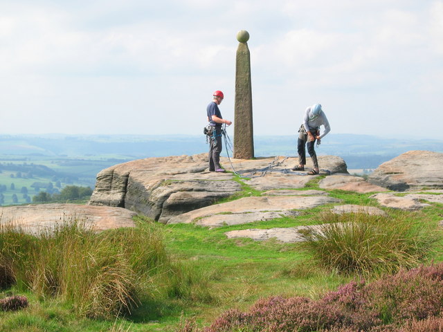
The hill is primarily composed of gritstone, which gives it a distinctive character and attracts climbers and hikers from far and wide. Its rugged and craggy terrain provides an excellent challenge for rock climbers, with various routes and difficulties available to suit all experience levels. Additionally, the hill is home to numerous boulders, which present their own set of challenges for those interested in the sport.

Birchen Edge is also famous for its unique rock formations, including the iconic “Three Ships” – a set of three large gritstone pillars that resemble sailing ships. These formations are a popular subject for photographers and artists, attracting visitors who wish to capture their beauty.

The hill is surrounded by diverse flora and fauna, with heather, bilberry, and bracken covering the slopes. This rich ecosystem supports a variety of bird species, including peregrine falcons and kestrels, making it a haven for birdwatchers.

Access to Birchen Edge is relatively easy, with several footpaths and trails leading to its summit. The location also boasts ample parking facilities and is a popular spot for picnics and family outings.

Overall, Birchen Edge offers a blend of natural beauty, recreational activities, and stunning vistas, making it a cherished destination for outdoor enthusiasts and nature lovers alike.

If you have any feedback on the listing, please let us know in the comments section below.

Birchen Edge Images

Images are sourced within 2km of 53.254122/-1.5844019 or Grid Reference SK2773. Thanks to Geograph Open Source API. All images are credited.

Moorland above Blake Brook Ramsley Moor slopes down to the valley of Blake Brook, and Birchen Edge rises behind.
Moorland above Blake Brook
Ramsley Moor slopes down to the valley of Blake Brook, and Birchen Edge rises behind.
Path passing Ramsley Reservoir A cleft was made in the dam when this reservoir was decommissioned, and the path now has to cross the stream flowing out.
Path passing Ramsley Reservoir
A cleft was made in the dam when this reservoir was decommissioned, and the path now has to cross the stream flowing out.
Cattle in long grass In a moorland enclosure above Blake Brook.
Cattle in long grass
In a moorland enclosure above Blake Brook.
Leash Fen You wouldn't want to try walking on this without a proper path.
Leash Fen
You wouldn't want to try walking on this without a proper path.
Parallel roads near Robin Hood The A619 is just over the hedge to the right, as both roads climb up the valley of Heathy Lea Brook.
Parallel roads near Robin Hood
The A619 is just over the hedge to the right, as both roads climb up the valley of Heathy Lea Brook.
Path below Birchen Edge The edge is up to the right, but this path does not make any attempt to get to the top.
Path below Birchen Edge
The edge is up to the right, but this path does not make any attempt to get to the top.
Rough farmland above Robin Hood Farm The land under Birchen Edge can only be used for grazing. The valley continues down towards Baslow.
Rough farmland above Robin Hood Farm
The land under Birchen Edge can only be used for grazing. The valley continues down towards Baslow.
Path below Birchen Edge There is quite a lot of foliage restricting views.
Path below Birchen Edge
There is quite a lot of foliage restricting views.
Farmland below Birchen Edge Moorside Farm is mostly hidden behind a wall.
Farmland below Birchen Edge
Moorside Farm is mostly hidden behind a wall.
Birchen Edge Seen from a path which runs below the edge.
Birchen Edge
Seen from a path which runs below the edge.
Boulder below Birchen Edge An erratic a short distance from the rocks of Birchen Edge.
Boulder below Birchen Edge
An erratic a short distance from the rocks of Birchen Edge.
Trig point on Birchen Edge There are views from the edge to Froggatt Edge and White Edge.
Trig point on Birchen Edge
There are views from the edge to Froggatt Edge and White Edge.
Birchen Edge Near the northern end of Birchen Edge.
Birchen Edge
Near the northern end of Birchen Edge.
Moorland above Birchen Edge A large plateau at around 300 metres above sea level.
Moorland above Birchen Edge
A large plateau at around 300 metres above sea level.
Path off Birchen Edge The northern end where the edge fades away. The A621 can be seen ahead climbing onto Ramsley Moor.
Path off Birchen Edge
The northern end where the edge fades away. The A621 can be seen ahead climbing onto Ramsley Moor.
Path up to Birchen Edge The edge is off to the right and the path approaches it from the northern end. The going on this path was fine in summer, but I would not fancy it in winter when I imagine it would be extremely soggy.
Path up to Birchen Edge
The edge is off to the right and the path approaches it from the northern end. The going on this path was fine in summer, but I would not fancy it in winter when I imagine it would be extremely soggy.
Path down to Clodhall Lane The path descends from Birchen Edge on ground that has the potential to be very soggy. The valley of Bar Brook is ahead.
Path down to Clodhall Lane
The path descends from Birchen Edge on ground that has the potential to be very soggy. The valley of Bar Brook is ahead.
Bar Brook Looking upstream from Clodhall Lane with Ramsley Moor in the background.
Bar Brook
Looking upstream from Clodhall Lane with Ramsley Moor in the background.
Show me another place!

Birchen Edge is located at Grid Ref: SK2773 (Lat: 53.254122, Lng: -1.5844019)

Administrative County: Derbyshire

District: Derbyshire Dales

Police Authority: Derbyshire

What 3 Words

///chills.report.mixing. Near Baslow, Derbyshire

Nearby Locations

Birchen Edge

Related Wikis

Birchen Edge

Birchen Edge is a gritstone rock face in the Peak District, England, popular with walkers and novice climbers as most of the climbing routes are in the...

Gardom's Edge

Gardom's Edge is a rocky outcrop near Baslow in Derbyshire, England. The shelf between Gardom's Edge and Birchen Edge is now moorland used for grazing...

Barbrook One

Barbrook One (grid reference SK27857558) is a stone circle on Ramsley Moor in the Peak District. == Description == "Barbrook No. 1" is an embanked stone...

Baslow

Baslow is a village in Derbyshire, England, in the Peak District, situated between Sheffield and Bakewell, just over 1 mile (1.6 km) north of Chatsworth...

Nearby Amenities

Located within 500m of 53.254122,-1.5844019
Nelsons Monument
Historic: monument
Wikidata: Q26380574
Lat/Long: 53.2527809/-1.5836277
Three Ships
Lat/Long: 53.2527082/-1.5830668
Birchen Edge
Ele: 310
Man Made: survey_point
Ref: S2154
Tpuk Ref: 1376
Lat/Long: 53.2541312/-1.5844227
Archaeological Site: hut_circle
Historic: archaeological_site
Historic Civilization: prehistoric
Lat/Long: 53.2541113/-1.5897736
Victory
Climbing: crag
Climbing Boulder: yes
Climbing Rock: gritstone
Natural: rock
Sport: climbing
Lat/Long: 53.2527896/-1.5831255
Defiance
Climbing: crag
Climbing Boulder: yes
Climbing Rock: gritstone
Natural: rock
Sport: climbing
Lat/Long: 53.2527255/-1.5830098
Royal Soverin
Climbing: crag
Climbing Boulder: yes
Climbing Rock: gritstone
Natural: rock
Sport: climbing
Lat/Long: 53.2526625/-1.582935
The data included in this document is from www.openstreetmap.org. The data is made available under ODbL.

Have you been to Birchen Edge?

Leave your review of Birchen Edge below (or comments, questions and feedback).