Bole Hill

Hill, Mountain in Derbyshire Derbyshire Dales

England

Bole Hill

Road above Bakewell Road to the west of Bakewell.
Road above Bakewell Credit: Philip Halling

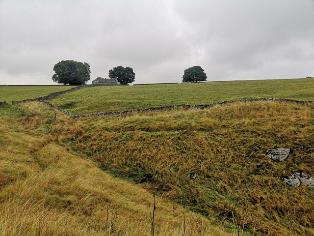
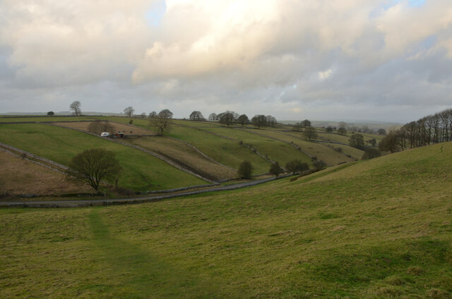
Bole Hill is a prominent hill located in Derbyshire, England. It is situated within the Peak District National Park, just north of the village of Holmesfield. Rising to an elevation of 382 meters (1,253 feet), Bole Hill stands as a significant landmark in the area.

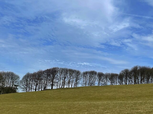
The hill is characterized by its distinctive shape, forming a rounded dome-like structure that offers panoramic views of the surrounding countryside. It is primarily composed of Millstone Grit, a type of sandstone that is common in the region. The composition of the hill makes it a popular destination for rock climbing enthusiasts who are attracted to its rugged and challenging terrain.

Bole Hill is also known for its rich history, with evidence of human activity dating back thousands of years. Archaeological excavations have revealed the presence of ancient burial mounds, suggesting that the hill held religious or ceremonial significance to the prehistoric communities that once inhabited the area.

Today, Bole Hill attracts a range of outdoor enthusiasts, including walkers and hikers who are drawn to its scenic trails and breathtaking views. The hill is also a favorite spot for picnickers and nature lovers, offering a peaceful and tranquil setting to enjoy the beauty of the Peak District.

Overall, Bole Hill is a notable feature of the Derbyshire landscape, providing a combination of natural beauty, recreational opportunities, and a glimpse into the region's historical past.

If you have any feedback on the listing, please let us know in the comments section below.

Bole Hill Images

Images are sourced within 2km of 53.205057/-1.7259378 or Grid Reference SK1867. Thanks to Geograph Open Source API. All images are credited.

Road above Bakewell Road to the west of Bakewell.
Road above Bakewell
Road to the west of Bakewell.
Farm Buildings near Haddon Grove Farm Taken from footpath on northern edge of Lathkill Dale
Farm Buildings near Haddon Grove Farm
Taken from footpath on northern edge of Lathkill Dale
Magpie Mine in the Mist, Derbyshire The ruins of the Magpie Mine appearing out of the mist on a winter afternoon in the Derbyshire Peak District.
Magpie Mine in the Mist, Derbyshire
The ruins of the Magpie Mine appearing out of the mist on a winter afternoon in the Derbyshire Peak District.
View of Kirk Dale, near Bakewell, Derbyshire
Public Footpath in Upper Kirk Dale, Derbyshire The footpath from Sheldon towards Over Haddon, where it crosses through Kirk Dale, in the Derbyshire Peak District.
Public Footpath in Upper Kirk Dale, Derbyshire
The footpath from Sheldon towards Over Haddon, where it crosses through Kirk Dale, in the Derbyshire Peak District.
Stile at the corner of Four Fields, Derbyshire A typical stone stile on a public footpath in the Derbyshire Peak District, at Melbourne Farm, near Bakewell.
Stile at the corner of Four Fields, Derbyshire
A typical stone stile on a public footpath in the Derbyshire Peak District, at Melbourne Farm, near Bakewell.
Grass fields and drystone walls A typical White Peak landscape near Bole Hill Farm
Grass fields and drystone walls
A typical White Peak landscape near Bole Hill Farm
Broken drystone wall On moorland above the valley of the River Wye
Broken drystone wall
On moorland above the valley of the River Wye
Little Shacklow Wood
Gate in a broken wall On a footpath approaching Lower Farm
Gate in a broken wall
On a footpath approaching Lower Farm
Gate and footpath sign at Lower Farm The gate has an unusual and distinctive design
Gate and footpath sign at Lower Farm
The gate has an unusual and distinctive design
Approaching Magpie Mine Magpie Mine is a well-preserved disused lead mine near the village of Sheldon  There were five lead mines here (Magpie Mine, Dirty Red Soil, Great Red Soil, Maypit and Horsesteps) and the site is a protected Scheduled Monument.
<span class="nowrap"><a title="https://en.wikipedia.org/wiki/Magpie_Mine" rel="nofollow ugc noopener" href="https://en.wikipedia.org/wiki/Magpie_Mine">Link</a><img style="margin-left:2px;" alt="External link" title="External link - shift click to open in new window" src="https://s1.geograph.org.uk/img/external.png" width="10" height="10"/></span>
Approaching Magpie Mine
Magpie Mine is a well-preserved disused lead mine near the village of Sheldon There were five lead mines here (Magpie Mine, Dirty Red Soil, Great Red Soil, Maypit and Horsesteps) and the site is a protected Scheduled Monument. LinkExternal link
Lower Farm, Sheldon A 19th century farmhouse which looks to have been converted to provide holiday accommodation
Lower Farm, Sheldon
A 19th century farmhouse which looks to have been converted to provide holiday accommodation
Magpie Mine Magpie Mine is a well-preserved disused lead mine near the village of Sheldon. The site had five lead mines (Magpie Mine, Dirty Red Soil, Great Red Soil, Maypit and Horsesteps) and is a protected Scheduled Monument.
<span class="nowrap"><a title="https://en.wikipedia.org/wiki/Magpie_Mine" rel="nofollow ugc noopener" href="https://en.wikipedia.org/wiki/Magpie_Mine">Link</a><img style="margin-left:2px;" alt="External link" title="External link - shift click to open in new window" src="https://s1.geograph.org.uk/img/external.png" width="10" height="10"/></span>
Magpie Mine
Magpie Mine is a well-preserved disused lead mine near the village of Sheldon. The site had five lead mines (Magpie Mine, Dirty Red Soil, Great Red Soil, Maypit and Horsesteps) and is a protected Scheduled Monument. LinkExternal link
Replica Horse Gin at Magpie Mine Magpie Mine is a rare survivor of the Peak District lead mining industry and is a scheduled ancient monument. The horse gin is a replica of a horse powered machine that would have been used to bring the lead ore to the surface.
Photographed in better weather than my previous visit here in 2012. <a href="https://www.geograph.org.uk/photo/2951248">SK1768 : Replica horse gin at Magpie Mine</a>
<span class="nowrap"><a title="https://en.wikipedia.org/wiki/Magpie_Mine" rel="nofollow ugc noopener" href="https://en.wikipedia.org/wiki/Magpie_Mine">Link</a><img style="margin-left:2px;" alt="External link" title="External link - shift click to open in new window" src="https://s1.geograph.org.uk/img/external.png" width="10" height="10"/></span>
Replica Horse Gin at Magpie Mine
Magpie Mine is a rare survivor of the Peak District lead mining industry and is a scheduled ancient monument. The horse gin is a replica of a horse powered machine that would have been used to bring the lead ore to the surface. Photographed in better weather than my previous visit here in 2012. SK1768 : Replica horse gin at Magpie Mine LinkExternal link
Walled footpath near Magpie Mine
Winter trees on the skyline A narrow strip of woodland above Kirk Dale
Winter trees on the skyline
A narrow strip of woodland above Kirk Dale
Stile in a drystone wall On a hillside above Over Haddon
Stile in a drystone wall
On a hillside above Over Haddon
Show me another place!

Bole Hill is located at Grid Ref: SK1867 (Lat: 53.205057, Lng: -1.7259378)

Administrative County: Derbyshire

District: Derbyshire Dales

Police Authority: Derbyshire

What 3 Words

///joints.curtail.fellow. Near Bakewell, Derbyshire

Nearby Locations

Bole Hill

Related Wikis

Magpie Mine

Magpie Mine is a well-preserved disused lead mine near the village of Sheldon in Derbyshire, England, in the parish of Ashford in the Water. The walled...

St Michael and All Angels' Church, Sheldon

St Michael and All Angels’ Church, Sheldon is a Grade II listed parish church in the Church of England in Sheldon, Derbyshire. == History == The original...

Sheldon, Derbyshire

Sheldon is a village in the Derbyshire Peak District, England near Bakewell. It is best known for being the closest village to Magpie Mine, a lead mine...

Ashford Black Marble

Ashford Black Marble is the name given to a dark limestone, quarried from mines near Ashford-in-the-Water, in Derbyshire, England. Once cut, turned and...

Over Haddon

Over Haddon is a small village and civil parish in Derbyshire, England. The population of the civil parish (including Nether Haddon) at the 2011 Census...

St Anne's Church, Over Haddon

St Anne's Church, Over Haddon is a Grade II listed parish church in the Church of England in Over Haddon, Derbyshire. == History == The church was built...

Holy Trinity Church, Ashford-in-the-Water

Holy Trinity Church, Ashford-in-the-Water is a Grade II listed parish church in the Church of England: 66  in Ashford-in-the-Water, Derbyshire. == History... ==

Ashford-in-the-Water

Ashford-in-the-Water is a village and civil parish in the Derbyshire Peak District, England. The village is on the River Wye, 2 miles (3 km) north-west...

Nearby Amenities

Located within 500m of 53.205057,-1.7259378
Bole Hill
Ele: 356
Natural: peak
Source: old OS map
Lat/Long: 53.2060639/-1.7276903
Barrier: stile
Material: stone
Source: survey;gps
Stile: stepover
Lat/Long: 53.2048783/-1.7184718
Barrier: stile
Material: wood
Source: survey;gps
Stile: stepover
Lat/Long: 53.2054232/-1.7200201
Barrier: stile
Material: stone
Source: survey;gps
Stile: stepover
Lat/Long: 53.2063729/-1.7224295
Barrier: stile
Material: wood
Source: survey;gps
Stile: stepover
Lat/Long: 53.2068298/-1.7229639
Barrier: stile
Material: stone
Source: survey;gps
Stile: stepover
Lat/Long: 53.2078628/-1.7274629
Barrier: stile
Material: wood
Source: survey;gps
Stile: stepover
Lat/Long: 53.2079787/-1.7274742
Hiking: yes
Information: guidepost
Source: GPS survey
Tourism: information
Lat/Long: 53.2070061/-1.7253068
Ele: 355
Man Made: survey_point
Ref: S4153
Source: Bing & ground survey
Tpuk Ref: TP1521
Lat/Long: 53.205165/-1.7257904
The data included in this document is from www.openstreetmap.org. The data is made available under ODbL.

Have you been to Bole Hill?

Leave your review of Bole Hill below (or comments, questions and feedback).