Broom Hill

Hill, Mountain in Durham

England

Broom Hill

Low Hedleyhope Barn conversion and building site
Low Hedleyhope Credit: Oliver Dixon

Broom Hill is a small, picturesque hill located in Durham, England. Situated on the outskirts of the city, it is a popular destination for locals and tourists alike seeking outdoor activities and breathtaking views. Rising approximately 250 feet above sea level, Broom Hill is not classified as a mountain but rather a hill due to its relatively modest elevation.

The hill is covered in lush greenery, with a mix of grassy slopes and dense woodland. Visitors can enjoy a variety of walking and hiking trails that wind their way through the hill, providing opportunities to explore the surrounding natural beauty. The well-maintained paths offer a range of difficulty levels, catering to both casual strollers and avid hikers.

One of the main attractions of Broom Hill is the panoramic view it offers of the surrounding landscape. From the summit, visitors can feast their eyes on the sprawling city of Durham, with its historic cathedral and castle dominating the skyline. On clear days, it is even possible to catch a glimpse of the distant North Pennines and the Durham coastline.

For those interested in local history, Broom Hill also holds significance. It is believed to have been the site of an ancient settlement, with various archaeological finds supporting this claim. The hill's location near the River Wear would have made it an ideal spot for early settlers to establish a community.

Overall, Broom Hill is a charming destination that combines natural beauty, outdoor activities, and historical interest. Whether you're looking for a leisurely stroll, a challenging hike, or a chance to soak in stunning vistas, this hill in Durham offers it all.

If you have any feedback on the listing, please let us know in the comments section below.

Broom Hill Images

Images are sourced within 2km of 54.747806/-1.7591921 or Grid Reference NZ1539. Thanks to Geograph Open Source API. All images are credited.

Low Hedleyhope Barn conversion and building site
Low Hedleyhope
Barn conversion and building site
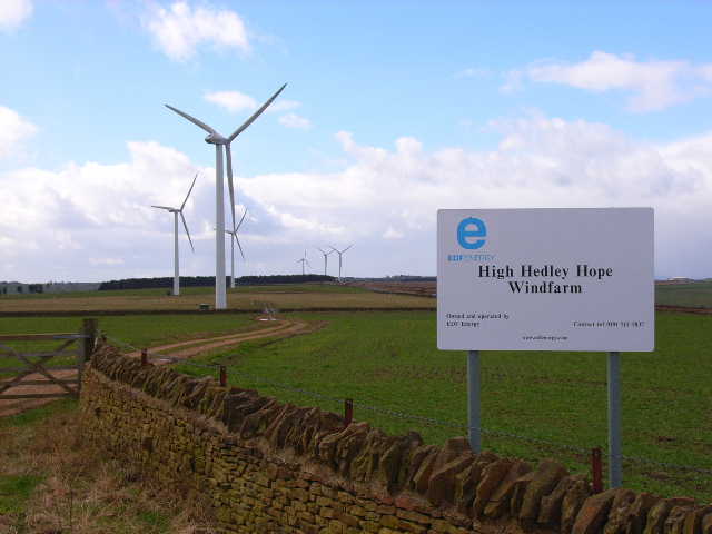
High Hedley Hope Windfarm One of the earlier of the many windfarms adorning the hills of County Durham
High Hedley Hope Windfarm
One of the earlier of the many windfarms adorning the hills of County Durham
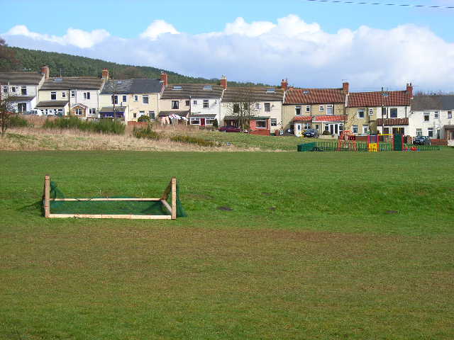
East Hedleyhope Looking east over the playing field
East Hedleyhope
Looking east over the playing field
Upper Deerness valley Stanley Wood in the background
Upper Deerness valley
Stanley Wood in the background
Hedley Hill Terrace Waterhouses In the Deerness Valley County Durham
Hedley Hill Terrace Waterhouses
In the Deerness Valley County Durham
Footbridge over River Deerness County Durham At East Hedleyhope
Footbridge over River Deerness County Durham
At East Hedleyhope
Apartments at East Hedleyhope Formerly the Deerness Valley Hotel in County Durham
Apartments at East Hedleyhope
Formerly the Deerness Valley Hotel in County Durham
Hedleyhope Wood with wind turbines Hedleyhope Wood is a narrow rectangular block of trees. The turbines are two of the six that comprise the Tow Law Wind Farm.
Hedleyhope Wood with wind turbines
Hedleyhope Wood is a narrow rectangular block of trees. The turbines are two of the six that comprise the Tow Law Wind Farm.
West View of East Hedleyhope East Hedleyhope, a County Durham 'pit village' consists of two parallel terraces rising from the road below in the Deerness valley. West View is seen here.
West View of East Hedleyhope
East Hedleyhope, a County Durham 'pit village' consists of two parallel terraces rising from the road below in the Deerness valley. West View is seen here.
North Lane
North Lane
North Lane at St Thomas Church
The Church of St Thomas, Stanley Crook
The Church of St Thomas, Stanley Crook, Doorway
The Church of St Thomas, Stanley Crook, Interior Taken through a window
The Church of St Thomas, Stanley Crook, Interior
Taken through a window
The Church of St Thomas, Stanley Crook, Graveyard
Wolsingham Road
Wolsingham Road
Wolsingham Road
Wolsingham Road
Show me another place!

Broom Hill is located at Grid Ref: NZ1539 (Lat: 54.747806, Lng: -1.7591921)

Unitary Authority: County Durham

Police Authority: Durham

What 3 Words

///rocked.gurgling.letters. Near Tow Law, Co. Durham

Related Wikis

East Hedleyhope

East Hedleyhope is a village in County Durham, in England. It is situated about 8 miles (13 km) west of Durham, up the Deerness valley. The main village...

Stanley Crook

Stanley Crook is a village in County Durham, in England. It is situated to the north of Crook and Billy Row. The area is rural, surrounded by open farm...

Sunniside, Weardale

Sunniside is a small rural village to the east of Tow Law and north of Crook in County Durham, England. Sunniside has one pub, and a former post office...

Billy Row

Billy Row is a village in County Durham, England. It is situated a short distance to the north of Crook. According to the 2001 census Billy Row has a population...

Nearby Amenities

Located within 500m of 54.747806,-1.7591921
Broom Hill
Ele: 289.3
Natural: peak
Note: No record of trig point. Tag as razed although may not have existed
Razed Man Made: survey_point
Source: NPE
Lat/Long: 54.747919/-1.7591172
Generator Method: wind_turbine
Generator Output Electricity: 2.0 MW
Generator Source: wind
Generator Type: horizontal_axis
Power: generator
Source: Bing
Lat/Long: 54.7437262/-1.7595326
Generator Method: wind_turbine
Generator Output Electricity: 2.0 MW
Generator Source: wind
Generator Type: horizontal_axis
Power: generator
Source: Bing
Lat/Long: 54.7465588/-1.7541236
Generator Method: wind_turbine
Generator Output Electricity: 2.0 MW
Generator Source: wind
Generator Type: horizontal_axis
Power: generator
Source: Bing
Lat/Long: 54.7443799/-1.7641629
The data included in this document is from www.openstreetmap.org. The data is made available under ODbL.

Have you been to Broom Hill?

Leave your review of Broom Hill below (or comments, questions and feedback).