Coalpit Hill

Hill, Mountain in Yorkshire Richmondshire

England

Coalpit Hill

Stile near Downholme Bridge The stile gives walkers access to the footpath that takes them initially beside the River Swale before heading west towards Cat Bank and Marske.
Stile near Downholme Bridge Credit: Maigheach-gheal

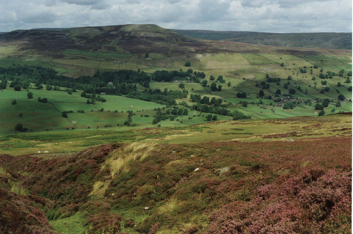
Coalpit Hill is a prominent hill located in the county of Yorkshire, England. It is situated in the northern part of the county, near the village of Kettleness, and forms part of the North York Moors National Park. With an elevation of approximately 320 meters (1,050 feet), it is classified as a hill rather than a mountain.

The hill gets its name from its historical association with coal mining activities that took place in the area during the 19th and early 20th centuries. Coalpit Hill was once an important source of coal extraction, providing fuel for the local communities and industries that thrived in the region. Today, remnants of the mining infrastructure can still be seen on the hill, serving as a reminder of its industrial past.

Coalpit Hill offers stunning panoramic views of the surrounding countryside. From its summit, visitors can enjoy breathtaking vistas of the North York Moors, with its vast expanses of rolling hills, heather-covered moorlands, and scattered woodlands. On a clear day, it is even possible to catch glimpses of the North Sea shimmering in the distance.

The hill is a popular destination for outdoor enthusiasts and nature lovers, who flock to Coalpit Hill to enjoy its scenic beauty and explore the numerous walking trails that crisscross its slopes. The area is home to a diverse range of flora and fauna, including heather, bilberry, and a variety of bird species, making it an ideal spot for wildlife observation and photography.

Overall, Coalpit Hill stands as a testament to both the natural wonders and industrial heritage of Yorkshire, attracting visitors seeking to immerse themselves in the region's rich history and picturesque landscapes.

If you have any feedback on the listing, please let us know in the comments section below.
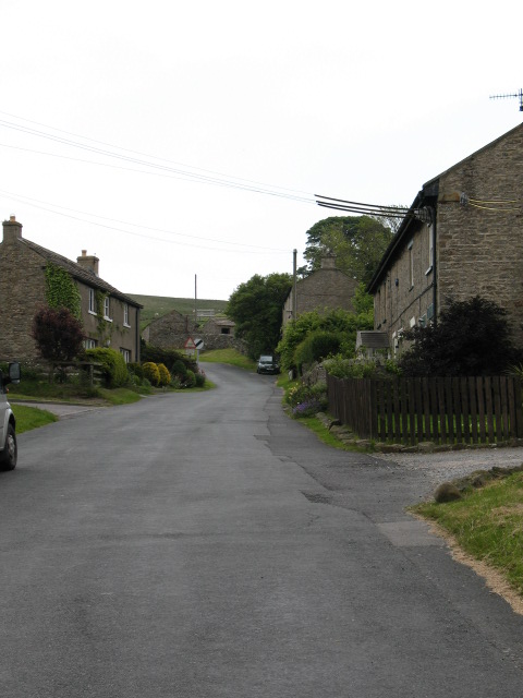
Coalpit Hill Images

Images are sourced within 2km of 54.381213/-1.8025561 or Grid Reference SE1298. Thanks to Geograph Open Source API. All images are credited.

Stile near Downholme Bridge The stile gives walkers access to the footpath that takes them initially beside the River Swale before heading west towards Cat Bank and Marske.
Stile near Downholme Bridge
The stile gives walkers access to the footpath that takes them initially beside the River Swale before heading west towards Cat Bank and Marske.
Downholme Bridge Late 17th century, Grade II listed bridge.  It is built of rubble with ashlar dressings.
Downholme Bridge
Late 17th century, Grade II listed bridge. It is built of rubble with ashlar dressings.
River Swale, Downholme Looking upstream from Downholme Bridge.

The River Swale is the northernmost tributary of the Yorkshire Ouse with its headwaters located in the eastern Yorkshire Dales, from where it flows in an easterly direction towards Richmond.
River Swale, Downholme
Looking upstream from Downholme Bridge. The River Swale is the northernmost tributary of the Yorkshire Ouse with its headwaters located in the eastern Yorkshire Dales, from where it flows in an easterly direction towards Richmond.
River Swale, Downholme Looking downstream from Downholme Bridge.
 
The River Swale is the northernmost tributary of the Yorkshire Ouse with its headwaters located in the eastern Yorkshire Dales, from where it flows in an easterly direction towards Richmond.
River Swale, Downholme
Looking downstream from Downholme Bridge. The River Swale is the northernmost tributary of the Yorkshire Ouse with its headwaters located in the eastern Yorkshire Dales, from where it flows in an easterly direction towards Richmond.
Grazing land, Downholme The field is currently being grazed by sheep, although cattle have also grazed the field recently.  The hay crib is designed to take large round bales.
Grazing land, Downholme
The field is currently being grazed by sheep, although cattle have also grazed the field recently. The hay crib is designed to take large round bales.
A6108 near Downholme Church
View of Lower Swaledale The picture was taken close to a newly constructed viewing point on the road which crosses Ministry of Defence land on Downholme Moor.
View of Lower Swaledale
The picture was taken close to a newly constructed viewing point on the road which crosses Ministry of Defence land on Downholme Moor.
Downholme Village Minor roads entering the village from the A6108
Downholme Village
Minor roads entering the village from the A6108
A6108, Downholme village
St. Michael and All Angels Church Near Downholme.
St. Michael and All Angels Church
Near Downholme.
Mole Hills near Downholme Side Bank Wood in the sun.
Mole Hills near Downholme
Side Bank Wood in the sun.
Large Lay by on A6108 Just north of Downholme Bridge
Large Lay by on A6108
Just north of Downholme Bridge
Approaching Downholme Bridge junction
Downholme church from A6108
A6108 entering Downholme
A6108 south of Downholme
Downholme church It wasn't a Sunday - maybe the livestock take a day of rest then, but getting to the gate to the churchyard from the road (via a short path over the pastureland) was a bit of a mission, as the local sheep chose to mob me, causing grave concern...
Downholme church
It wasn't a Sunday - maybe the livestock take a day of rest then, but getting to the gate to the churchyard from the road (via a short path over the pastureland) was a bit of a mission, as the local sheep chose to mob me, causing grave concern...
Bridge over Badger Beck The bridge over Badger Beck looking South East from near Hudswell Grange. Taken while staying at the Grange whilst on exercise.
Bridge over Badger Beck
The bridge over Badger Beck looking South East from near Hudswell Grange. Taken while staying at the Grange whilst on exercise.
Show me another place!

Coalpit Hill is located at Grid Ref: SE1298 (Lat: 54.381213, Lng: -1.8025561)

Division: North Riding

Administrative County: North Yorkshire

District: Richmondshire

Police Authority: North Yorkshire

What 3 Words

///clips.reserves.cropping. Near Richmond, North Yorkshire

Related Wikis

Downholme

Downholme is a village and civil parish in North Yorkshire, England. It is situated approximately 4 miles (6 km) west from the market town of Richmond...
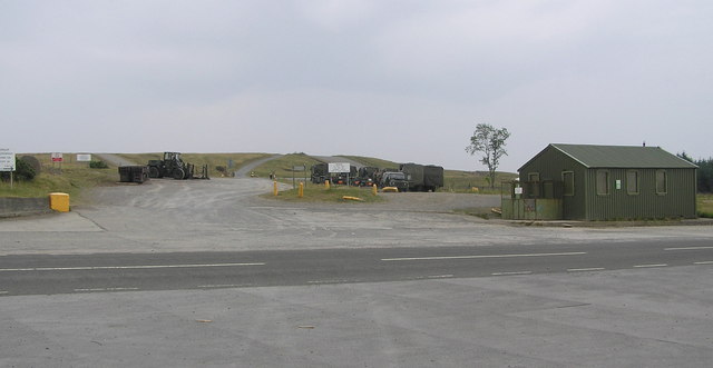
Hipswell Moor

Hipswell Moor is an area used for military training, near Catterick Garrison in North Yorkshire, England. It includes parts of the civil parishes of Barden...

Hudswell, North Yorkshire

Hudswell is a village and civil parish on the border of the Yorkshire Dales, in North Yorkshire, England. The population at the ONS Census 2011 was 353...

Walburn, North Yorkshire

Walburn is a hamlet and civil parish in North Yorkshire, England. It is located in lower Swaledale, 5 miles (8 km) south-west of Richmond. The population...

Scott Trial

The Scott Trial is a British motorcycle trials competition dating from 1914 run over an off-road course of approximately 70 miles. One of the most challenging...

Stainton, west North Yorkshire

Stainton is a hamlet and civil parish in the North Yorkshire district of North Yorkshire, England. It is located just outside the Yorkshire Dales National...

Applegarth, North Yorkshire

Applegarth is a historic settlement located north of the River Swale in Yorkshire, England. It lies about three-quarters of a mile north-east of the village...

Swaledale

Swaledale is a valley in North Yorkshire, England. It is one of the Yorkshire Dales, which are part of the Pennines, and within the Yorkshire Dales National...

Nearby Amenities

Located within 500m of 54.381213,-1.8025561
Historic: mine_shaft
Is In County: North Yorkshire
Is In Historic County: Yorkshire
Source: OS 1:25k
Lat/Long: 54.3851699/-1.7996915
Coalpit Hill
Is In County: North Yorkshire
Is In Historic County: Yorkshire
Natural: peak
Source: NPE
Lat/Long: 54.3816555/-1.802043
old shaft
Historic: mine_shaft
Source: OS 1:25k
Lat/Long: 54.3809837/-1.7970522
old shaft
Historic: mine_shaft
Source: OS 1:25k
Lat/Long: 54.3808962/-1.7958935
Historic: mine_shaft
Is In County: North Yorkshire
Is In Historic County: Yorkshire
Source: OS 1:25k
Lat/Long: 54.3853949/-1.8008931
The data included in this document is from www.openstreetmap.org. The data is made available under ODbL.

Have you been to Coalpit Hill?

Leave your review of Coalpit Hill below (or comments, questions and feedback).