Chalk Hill

Hill, Mountain in Gloucestershire Cotswold

England

Chalk Hill

New hedgerow near Swell Wold Farm
New hedgerow near Swell Wold Farm Credit: Jonathan Thacker

Chalk Hill is a prominent geographical feature located in the county of Gloucestershire, in southwestern England. Situated near the village of Cranham, it forms part of the Cotswold Hills, a designated Area of Outstanding Natural Beauty. As its name suggests, Chalk Hill is primarily composed of chalk, a soft white sedimentary rock that is commonly found in England.

Rising to an elevation of around 225 meters (738 feet), Chalk Hill offers breathtaking panoramic views of the surrounding countryside. Its distinctive chalky slopes are covered in a rich variety of vegetation, including grasses, wildflowers, and shrubs, creating a vibrant and picturesque landscape. The hill is also home to a diverse range of wildlife, with many species of birds, butterflies, and small mammals inhabiting the area.

Chalk Hill has historical significance and has been utilized by humans for centuries. Remnants of Iron Age hillforts can still be seen on the hill, indicating its strategic importance in ancient times. In addition, there are several footpaths and trails that wind their way up and around the hill, allowing visitors to explore its natural beauty and experience its tranquil setting.

The hill is a popular destination for outdoor enthusiasts, hikers, and nature lovers, offering opportunities for leisurely walks, birdwatching, and photography. Its accessibility and proximity to nearby villages and towns make it an ideal spot for day trips or weekend getaways.

Overall, Chalk Hill in Gloucestershire is a captivating natural landmark, boasting both scenic beauty and historical significance, making it a must-visit destination for those seeking a peaceful retreat in the heart of the English countryside.

If you have any feedback on the listing, please let us know in the comments section below.

Chalk Hill Images

Images are sourced within 2km of 51.93164/-1.8159724 or Grid Reference SP1225. Thanks to Geograph Open Source API. All images are credited.

New hedgerow near Swell Wold Farm
Edge of a plantation, Swell Wold
Clump of trees on a hill spur A significant attempt has been maed in this area to change the landscape over the last couple of decades or so. There are several new plantations and hedges transforming what could be one of the bleaker parts of the Cotswolds.
Clump of trees on a hill spur
A significant attempt has been maed in this area to change the landscape over the last couple of decades or so. There are several new plantations and hedges transforming what could be one of the bleaker parts of the Cotswolds.
Quarries in the Cotswolds In the farming landscape between Barton and the Slaughters.
Quarries in the Cotswolds
In the farming landscape between Barton and the Slaughters.
Our favourite barn Several Geographists have already photographed this barn.  I am proud to be in such august company
Our favourite barn
Several Geographists have already photographed this barn. I am proud to be in such august company
Fingerpost at Swell Wold Sign at the junction, with the well-photographed barn behind
Fingerpost at Swell Wold
Sign at the junction, with the well-photographed barn behind
A little valley
A little valley
Tree-lined road
Tree-lined road
Cotswold stone barn A roadside Cotswold stone barn I last photographed in December 2005 <a href="https://www.geograph.org.uk/photo/91082">SP1426 : Farm buildings in the Eye valley</a>.
Cotswold stone barn
A roadside Cotswold stone barn I last photographed in December 2005 SP1426 : Farm buildings in the Eye valley.
The entrance to Huntsman's Quarry The road is lined with quarries, being in the middle of the Cotswolds.
The entrance to Huntsman's Quarry
The road is lined with quarries, being in the middle of the Cotswolds.
The entrance to Huntsman's Quarry
Autumn leaves in the Cotswolds The roads seem to have few names and it's not near any named settlements.
Autumn leaves in the Cotswolds
The roads seem to have few names and it's not near any named settlements.
The Warden's Way The Warden's Way passing through a field approaching a farm building. This is a similar view to the first picture uploaded in this grid square in 2006 <a href="https://www.geograph.org.uk/photo/177993">SP1324 : The Wardens' Way</a>, the field is bare compared to 2006, and there are now fewer trees.
The Warden's Way
The Warden's Way passing through a field approaching a farm building. This is a similar view to the first picture uploaded in this grid square in 2006 SP1324 : The Wardens' Way, the field is bare compared to 2006, and there are now fewer trees.
Farm track and bridleway The Wardens' Way between Naunton and Upper Slaughter.
Farm track and bridleway
The Wardens' Way between Naunton and Upper Slaughter.
Field gateway and track The Wardens' Way follows this track, heading for Upper Slaughter.
Field gateway and track
The Wardens' Way follows this track, heading for Upper Slaughter.
Sign on the Wardens' Way Sign on the Wardens' Way near the village of Naunton.
Sign on the Wardens' Way
Sign on the Wardens' Way near the village of Naunton.
Entrance to Brockhill Farm Entrance to Brockhill Farm viewed from the Wardens' Way.
Entrance to Brockhill Farm
Entrance to Brockhill Farm viewed from the Wardens' Way.
Bridleway near Brockhill Farm A recently planted hedge separates the bridleway and Wardens' Way from the rest of this field near Brockhill Farm, Naunton.
Bridleway near Brockhill Farm
A recently planted hedge separates the bridleway and Wardens' Way from the rest of this field near Brockhill Farm, Naunton.
Show me another place!

Chalk Hill is located at Grid Ref: SP1225 (Lat: 51.93164, Lng: -1.8159724)

Administrative County: Gloucestershire

District: Cotswold

Police Authority: Gloucestershire

What 3 Words

///stun.fluid.springing. Near Westfield, Gloucestershire

Nearby Locations

Chalk Hill

Related Wikis

Huntsman's Quarry

Huntsman's Quarry (grid reference SP125259) is a 1.6-hectare (4.0-acre) geological Site of Special Scientific Interest in Gloucestershire, notified in...

Barton Bushes

Barton Bushes (grid reference SP110259) is a 5.7-hectare (14-acre) biological Site of Special Scientific Interest in Gloucestershire, notified in 1996...

Lark Wood

Lark Wood (grid reference SP104262) is a 1.11-hectare (2.7-acre) biological Site of Special Scientific Interest in Gloucestershire, notified in 1974. The...

St Andrew's Church, Naunton

St Andrew's Church is an Anglican parish church in Naunton, Gloucestershire, dedicated to St Andrew the Apostle. == History == Dating from the 13th century...

Condicote

Condicote is a small village in Gloucestershire, England. It is near the A424 road. It has a small church dedicated to St Nicholas. It has evidence of...

Barton, Gloucestershire

Barton is a village in Gloucestershire, on the Windrush River, near Naunton. It appears in written records as Berton as early as 1287. == References... ==

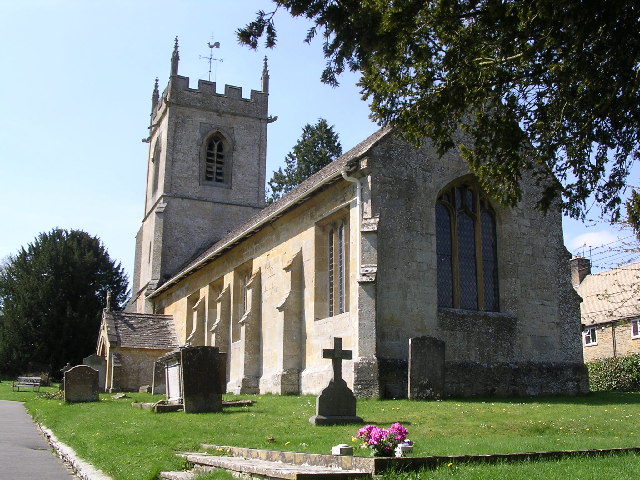
St Michael's and All Angels Church, Guiting Power

St Michael's and All Angels Church is in the village of Guiting Power, Gloucestershire, England. It is an active Anglican parish church in the deanery...

Naunton

Naunton is a village in Gloucestershire, England. It lies on the River Windrush in the Cotswolds, an area of outstanding natural beauty. Stow-on-the-Wold...

Related Videos

What does a Family Holiday at Cotswold Farm Park look like?

Did you know you can holiday with us at Cotswold Farm Park? Here's a little taste of what a fun filled family break with us looks ...

Ultimate Cotswold Summer Holidays! ⭐️ 3 NIGHTS FOR 2 - Code in Bio

Entry to the Farm Park each day of your stay ✓ Free entry to our summer events ✓ Regular activities for children ✓ Live music on ...

Nearby Amenities

Located within 500m of 51.93164,-1.8159724
Chalk Hill Farm
Power: pole
Transformer: distribution
Voltage Primary: 11000
Lat/Long: 51.9322514/-1.8126798
Power: pole
Lat/Long: 51.9322663/-1.8134013
Power: pole
Lat/Long: 51.9322646/-1.814334
Power: pole
Lat/Long: 51.9320972/-1.8157462
Power: pole
Lat/Long: 51.9319397/-1.8171524
Power: pole
Lat/Long: 51.9318991/-1.8182561
Power: pole
Lat/Long: 51.9318553/-1.8196642
Power: pole
Lat/Long: 51.9342327/-1.82135
Power: pole
Lat/Long: 51.9333272/-1.8213044
Power: pole
Lat/Long: 51.9325185/-1.8212628
Nosehill Farm
Power: pole
Transformer: distribution
Voltage Primary: 11000
Lat/Long: 51.9314911/-1.822671
Power: pole
Lat/Long: 51.9317763/-1.8212615
Power: pole
Lat/Long: 51.9312277/-1.8211971
Location Transition: yes
Power: pole
Lat/Long: 51.9303867/-1.8206768
The data included in this document is from www.openstreetmap.org. The data is made available under ODbL.

Have you been to Chalk Hill?

Leave your review of Chalk Hill below (or comments, questions and feedback).