Bowers Hill

Hill, Mountain in Yorkshire Craven

England

Bowers Hill

Little Crag, Beamsley Moor Looking North to Little Crag with Summerscales and A59 beyond.
Little Crag, Beamsley Moor Credit: John Chamberlain

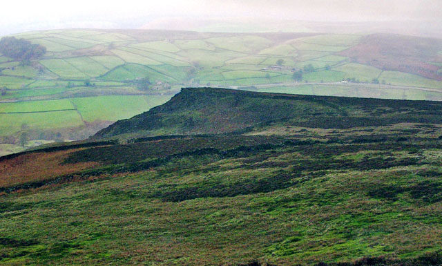
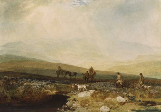
Bowers Hill is a prominent hill located in the Yorkshire Dales National Park, in the county of Yorkshire, England. Situated within the Pennines mountain range, it is a notable landmark that stands at an elevation of approximately 540 meters (1,772 feet) above sea level. The hill is part of the Bowers reservoir system, which supplies water to the surrounding areas.

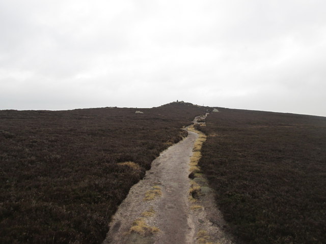
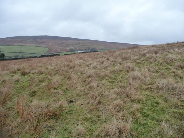
Known for its scenic beauty and panoramic views, Bowers Hill attracts numerous visitors, including hikers, walkers, and nature enthusiasts. The hill offers various trails and paths for outdoor activities, allowing visitors to explore the surrounding countryside and enjoy the peaceful ambiance of the Yorkshire Dales.

Covered with lush greenery, Bowers Hill features a diverse range of flora and fauna, making it an important habitat for wildlife. The area is home to several bird species, including skylarks and peregrine falcons, providing ample opportunities for birdwatching enthusiasts.

Bowers Hill also holds historical significance, with the remains of an ancient hillfort located at its summit. The fort, believed to have been built during the Iron Age, offers a glimpse into the region's past, attracting history enthusiasts and archaeologists alike.

Access to Bowers Hill is facilitated by nearby towns such as Settle and Ingleton, which provide amenities and services to visitors. The hill's accessibility, combined with its natural beauty and historical significance, makes it a popular destination for both locals and tourists seeking an escape into the Yorkshire countryside.

If you have any feedback on the listing, please let us know in the comments section below.

Bowers Hill Images

Images are sourced within 2km of 53.969162/-1.8712748 or Grid Reference SE0852. Thanks to Geograph Open Source API. All images are credited.

Little Crag, Beamsley Moor Looking North to Little Crag with Summerscales and A59 beyond.
Little Crag, Beamsley Moor
Looking North to Little Crag with Summerscales and A59 beyond.
Gateway below Naze Nib End The gateway gives access off Beamsley Moor, offering views over the valley created by Kex Beck
Gateway below Naze Nib End
The gateway gives access off Beamsley Moor, offering views over the valley created by Kex Beck
Summit of The Old Pike North eastern end of a ridge that starts at Beamsley Beacon - best seen in its entirety from Ilkley far below in the Wharfedale valley.
Not nearly as much visited as its twin, Beamsley Beacon, it is in fact slightly superior in altitude.
Summit of The Old Pike
North eastern end of a ridge that starts at Beamsley Beacon - best seen in its entirety from Ilkley far below in the Wharfedale valley. Not nearly as much visited as its twin, Beamsley Beacon, it is in fact slightly superior in altitude.
View towards Beamsley Beacon/Old Pike Ridge Looking towards the summit ridge that separates the twin points of Beamsley Beacon to the right, and The Old Pike to the left - seen from near Pemberton Well on the wastes of Beamsley Moor.
View towards Beamsley Beacon/Old Pike Ridge
Looking towards the summit ridge that separates the twin points of Beamsley Beacon to the right, and The Old Pike to the left - seen from near Pemberton Well on the wastes of Beamsley Moor.
The Old Pike Dog leg route from car park to bag Beamsley Beacon trig and cairn on route to The Old Pike. Stunning views after a frosty November morning on this very popular family friendly hill.
Name: The Old Pike
Hill number: 108421
Height: 400m / 1312ft
Area: 35B: The Central Pennines
Class: 4
Grid ref: SE102526 (est)
Drop: 33m
Col: 367m
The Old Pike
Dog leg route from car park to bag Beamsley Beacon trig and cairn on route to The Old Pike. Stunning views after a frosty November morning on this very popular family friendly hill. Name: The Old Pike Hill number: 108421 Height: 400m / 1312ft Area: 35B: The Central Pennines Class: 4 Grid ref: SE102526 (est) Drop: 33m Col: 367m
Path between Beamsley Beacon and The Old Pike Heading towards The Old Pike
Path between Beamsley Beacon and The Old Pike
Heading towards The Old Pike
The old Pike
The old Pike
Looking towards Blackhill House, Lingbar Looking north from a hillock by Moor End Farm.
Looking towards Blackhill House, Lingbar
Looking north from a hillock by Moor End Farm.
Summit of The Old Pike Revisited The summit outcrops appear to have sprouted a fingerpost since my last visited - indicating the way to Littlegate.
Twinned with Beamsley Beacon, a little under a kilometre to the south west.
Summit of The Old Pike Revisited
The summit outcrops appear to have sprouted a fingerpost since my last visited - indicating the way to Littlegate. Twinned with Beamsley Beacon, a little under a kilometre to the south west.
Bolton Priory from above Waterfall Bridge
Helicopter at Devonshire Arms Hotel, Bolton Bridge
Beamsley Lane, bridge This is the eastern parapet of the Beamsley Bridge on Beamlsey Lane. Cut into the 2nd course of stone at the left side of the parapet is a benchmark.
Beamsley Lane, bridge
This is the eastern parapet of the Beamsley Bridge on Beamlsey Lane. Cut into the 2nd course of stone at the left side of the parapet is a benchmark.
Beamsley Lane, bridge A wider angle showing the full bridge. On the left is the eastern parapet of  Beamsley Bridge on Beamlsey Lane. Cut into the 2nd course of stone at the left side of the parapet is a benchmark.
Beamsley Lane, bridge
A wider angle showing the full bridge. On the left is the eastern parapet of Beamsley Bridge on Beamlsey Lane. Cut into the 2nd course of stone at the left side of the parapet is a benchmark.
Beamsley, gatepost and footpath This gateway and footpath fingerpost is on the eastern side of Beamsley Lane, and just to the south of the village. On the OS database one of the gateposts had a benchmark cut into the stone. Today only 1 gatepost remains, and there is no benchmark.
Beamsley, gatepost and footpath
This gateway and footpath fingerpost is on the eastern side of Beamsley Lane, and just to the south of the village. On the OS database one of the gateposts had a benchmark cut into the stone. Today only 1 gatepost remains, and there is no benchmark.
Beamsley, gatepost This gatepost is on the east side of Beamsley Lane. This is a relatively new entrance to a residential property, and has a repositioned stone gatepost on the left of the entrance. There is a benchmark cut into the gatepost and is about 1 foot from ground level.
Beamsley, gatepost
This gatepost is on the east side of Beamsley Lane. This is a relatively new entrance to a residential property, and has a repositioned stone gatepost on the left of the entrance. There is a benchmark cut into the gatepost and is about 1 foot from ground level.
Beamsley, gatepost and entrance This is a relatively new entrance to a residential property on the east side of Beamsley Lane. There is a gatepost on the left of the entrance which has been repositioned. There is a benchmark cut into the gatepost and is about 1 foot from ground level.
Beamsley, gatepost and entrance
This is a relatively new entrance to a residential property on the east side of Beamsley Lane. There is a gatepost on the left of the entrance which has been repositioned. There is a benchmark cut into the gatepost and is about 1 foot from ground level.
Beamsley, gatepost This gatepost is on the west side of Beamsley lane just south of the village. The gatepost has been repositioned, and is now the entrance to car parking for houses on the lane side. the mark is less than 1 foot from ground level.
Beamsley, gatepost
This gatepost is on the west side of Beamsley lane just south of the village. The gatepost has been repositioned, and is now the entrance to car parking for houses on the lane side. the mark is less than 1 foot from ground level.
Beamsley, gatepost and entrance A wider angle showing the entrance to a large parking area for houses on the west side of Beamsley Lane. The gatepost has been repositioned and has a benchmark which is east facing and less than 1 foot from ground level.
Beamsley, gatepost and entrance
A wider angle showing the entrance to a large parking area for houses on the west side of Beamsley Lane. The gatepost has been repositioned and has a benchmark which is east facing and less than 1 foot from ground level.
Show me another place!

Bowers Hill is located at Grid Ref: SE0852 (Lat: 53.969162, Lng: -1.8712748)

Division: West Riding

Administrative County: North Yorkshire

District: Craven

Police Authority: North Yorkshire

What 3 Words

///disposal.brushing.troll. Near Addingham, West Yorkshire

Related Wikis

Beamsley Hospital

Beamsley Hospital is an Almshouse building at Beamsley, near Skipton in North Yorkshire, and founded in 1593 by the Lady Margaret Russell, the Countess...

Beamsley

Beamsley is a village and civil parish in the Craven district of North Yorkshire, England. It is just within the boundary of the Yorkshire Dales National...

Farfield Friends Meeting House

Farfield Friends Meeting House is a Quaker meeting house no longer regularly in use by a Quaker meeting and now owned by the Historic Chapels Trust. It...

Hazlewood

Hazlewood is a hamlet in the English county of North Yorkshire. Hazlewood lies to the east of the town of Skipton by 7.5 miles (12.1 km) and is located...

Bolton Abbey

Bolton Abbey in Wharfedale, North Yorkshire, England, takes its name from the ruins of the 12th-century Augustinian monastery now known as Bolton Priory...

Bolton Priory

Bolton Priory, whose full title is The Priory Church of St Mary and St Cuthbert, Bolton Abbey, is a Grade I listed parish church of the Church of England...

Bolton Abbey (village)

Bolton Abbey is a village and civil parish in the Craven district of North Yorkshire, England, 22 miles (35 km) north-west of Leeds. The village lies in...

Hazlewood with Storiths

Hazlewood with Storiths is a civil parish in the Craven district of North Yorkshire, England. The population of the civil parish as of the 2011 census...

Nearby Amenities

Located within 500m of 53.969162,-1.8712748
Crier Hill
Ele: 159.7
Man Made: survey_point
Natural: peak
Source: OS 1:25k;OS 1853
Source Name: OS 1:25k;OS 1853
Lat/Long: 53.9671553/-1.877372
Natural: spring
Source: OS 1:25k
Lat/Long: 53.9729202/-1.8692314
Natural: spring
Source: OS 1:25k
Lat/Long: 53.9727741/-1.8731661
Haws Well
Natural: spring
Note: location interpolated
Source: OS 1853
Lat/Long: 53.9663479/-1.8741757
Resphill Well
Natural: spring
Source: OS 1853
Lat/Long: 53.9686025/-1.8776894
Fixme: Are these still here? Is there a birdge?
Ford: stepping_stones
Source: OS 1853
Lat/Long: 53.9697903/-1.8780971
Carbriggs
Archaeological Site: building
Description: Former C19th farm or barn.
Historic: archaeological_site
Source: OS 1853
Lat/Long: 53.9700792/-1.8744843
Barrier: stile
Material: wood
Stile: stepover
Lat/Long: 53.9665333/-1.8661891
Barrier: stile
Material: wood
Stile: stepover
Lat/Long: 53.9665244/-1.8670265
Barrier: stile
Dog Gate: yes
Height: 2
Material: wood
Stile: ladder
Lat/Long: 53.9663105/-1.8657452
The data included in this document is from www.openstreetmap.org. The data is made available under ODbL.

Have you been to Bowers Hill?

Leave your review of Bowers Hill below (or comments, questions and feedback).