Black Hill

Hill, Mountain in Yorkshire Harrogate

England

Black Hill

Track leading to Moor House, How Stean, Nidderdale According to the 1909 map there was a benchmark at this location. the cutmark was likely on a gatepost or a stone within the wall. Nothing was found.
Track leading to Moor House, How Stean, Nidderdale Credit: Mel Towler

Black Hill is a prominent peak located in the Pennines, a mountain range in the county of Yorkshire, England. Standing at an elevation of 582 meters (1,909 feet), it is considered one of the highest points in the region. The hill is situated within the Peak District National Park, offering breathtaking views of the surrounding countryside.

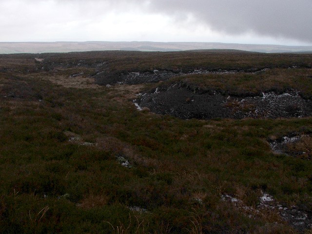
The terrain of Black Hill is predominantly moorland, characterized by extensive stretches of heather and peat bogs. The area is renowned for its unique flora and fauna, including several rare bird species such as the golden plover and merlin. The diverse ecosystem attracts nature enthusiasts and ornithologists from far and wide.

The hill is accessible via various hiking trails, making it a popular destination for outdoor activities. The Pennine Way, a long-distance footpath, passes near Black Hill, providing an opportunity for adventurous hikers to include it in their route. The climb to the summit can be challenging, but the rewarding panoramic views from the top make it all worthwhile.

Black Hill has a rich historical significance as well. The area was once heavily used for peat extraction, evidenced by the remains of peat cutting activities that can still be seen today. Additionally, the hill was a site of anti-aircraft defenses during World War II, with remnants of war bunkers and observation posts scattered across its slopes.

In conclusion, Black Hill is a striking mountainous peak located in Yorkshire's Pennines. Its rugged terrain, diverse wildlife, and historical importance make it a captivating destination for both nature lovers and history enthusiasts.

If you have any feedback on the listing, please let us know in the comments section below.

Black Hill Images

Images are sourced within 2km of 54.139418/-1.8846466 or Grid Reference SE0771. Thanks to Geograph Open Source API. All images are credited.

Track leading to Moor House, How Stean, Nidderdale According to the 1909 map there was a benchmark at this location. the cutmark was likely on a gatepost or a stone within the wall. Nothing was found.
Track leading to Moor House, How Stean, Nidderdale
According to the 1909 map there was a benchmark at this location. the cutmark was likely on a gatepost or a stone within the wall. Nothing was found.
Benchmark cut into stone post, Nidderdale The benchmark is cut into a stone post which is part of the trackside wall on the south side of Hard Gap Lane. Wider view <a href="https://www.geograph.org.uk/photo/7552865">SE0872 : Drystone wall, Hard Gap Lane, Nidderdale</a>
Benchmark cut into stone post, Nidderdale
The benchmark is cut into a stone post which is part of the trackside wall on the south side of Hard Gap Lane. Wider view SE0872 : Drystone wall, Hard Gap Lane, Nidderdale
Drystone wall, Hard Gap Lane, Nidderdale There is a benchmark cut into the stone post which is part of the trackside wall on the south side of Hard Gap Lane. Closer view <a href="https://www.geograph.org.uk/photo/7552863">SE0872 : Benchmark cut into stone post, Nidderdale</a>
Drystone wall, Hard Gap Lane, Nidderdale
There is a benchmark cut into the stone post which is part of the trackside wall on the south side of Hard Gap Lane. Closer view SE0872 : Benchmark cut into stone post, Nidderdale
Benchmark cut into large rock, Nidderdale The benchmark is cut into a large boulder on the north side of Moor Hall Lane, Nidderdale. Wider view <a href="https://www.geograph.org.uk/photo/7552874">SE0872 : Moor Hall Lane, How Stean, Nidderdale</a>
Benchmark cut into large rock, Nidderdale
The benchmark is cut into a large boulder on the north side of Moor Hall Lane, Nidderdale. Wider view SE0872 : Moor Hall Lane, How Stean, Nidderdale
Moor Hall Lane, How Stean, Nidderdale There is a pivot benchmark cut into the large boulder on the north side of Moor Hall Lane, Nidderdale. Closer view <a href="https://www.geograph.org.uk/photo/7552872">SE0872 : Benchmark cut into large rock, Nidderdale</a>
Moor Hall Lane, How Stean, Nidderdale
There is a pivot benchmark cut into the large boulder on the north side of Moor Hall Lane, Nidderdale. Closer view SE0872 : Benchmark cut into large rock, Nidderdale
Benchmark cut into large rock, Nidderdale The benchmark is cut into a large boulder on the south side of Moor Hall Lane, Nidderdale. Wider view <a href="https://www.geograph.org.uk/photo/7552878">SE0872 : Moor Hall Lane, How Stean, Nidderdale</a>
Benchmark cut into large rock, Nidderdale
The benchmark is cut into a large boulder on the south side of Moor Hall Lane, Nidderdale. Wider view SE0872 : Moor Hall Lane, How Stean, Nidderdale
Moor Hall Lane, How Stean, Nidderdale There is a pivot benchmark cut into the large boulder on the south side of Moor Hall Lane, Nidderdale. Closer view <a href="https://www.geograph.org.uk/photo/7552876">SE0872 : Benchmark cut into large rock, Nidderdale</a>
Moor Hall Lane, How Stean, Nidderdale
There is a pivot benchmark cut into the large boulder on the south side of Moor Hall Lane, Nidderdale. Closer view SE0872 : Benchmark cut into large rock, Nidderdale
Benchmark cut into field wall, Nidderdale The pivot benchmark is cut into a protruding stone in the drystone wall on the north side of Moor Hall Lane. wider view <a href="https://www.geograph.org.uk/photo/7552885">SE0872 : Moor Hall Lane, Nidderdale</a>
Benchmark cut into field wall, Nidderdale
The pivot benchmark is cut into a protruding stone in the drystone wall on the north side of Moor Hall Lane. wider view SE0872 : Moor Hall Lane, Nidderdale
Moor Hall Lane, Nidderdale There is a pivot benchmark cut into a protruding stone in the drystone wall on the north side of Moor Hall Lane. Closer view <a href="https://www.geograph.org.uk/photo/7552882">SE0872 : Benchmark cut into field wall, Nidderdale</a>
Moor Hall Lane, Nidderdale
There is a pivot benchmark cut into a protruding stone in the drystone wall on the north side of Moor Hall Lane. Closer view SE0872 : Benchmark cut into field wall, Nidderdale
Benchmark cut into large rock, Nidderdale The pivot benchmark is cut into a lone large rock at this location on the open moorland at Black Hill Drive in Nidderdale. Wider view <a href="https://www.geograph.org.uk/photo/7552893">SE0872 : Black Hill Drive with views of How Stean in the distance</a>
Benchmark cut into large rock, Nidderdale
The pivot benchmark is cut into a lone large rock at this location on the open moorland at Black Hill Drive in Nidderdale. Wider view SE0872 : Black Hill Drive with views of How Stean in the distance
Black Hill Drive with views of How Stean in the distance The pivot benchmark is cut into a lone rock on the open moorland at Black Hill Drive in Nidderdale. Closer view <a href="https://www.geograph.org.uk/photo/7552891">SE0872 : Benchmark cut into large rock, Nidderdale</a>
Black Hill Drive with views of How Stean in the distance
The pivot benchmark is cut into a lone rock on the open moorland at Black Hill Drive in Nidderdale. Closer view SE0872 : Benchmark cut into large rock, Nidderdale
Drystone wall on Moor Hall Lane, Nidderdale According to the 1909 map there is a benchmark at this location, likely cut into the wall. Nothing was found.
Drystone wall on Moor Hall Lane, Nidderdale
According to the 1909 map there is a benchmark at this location, likely cut into the wall. Nothing was found.
Trackside wall on Stean Lane, Nidderdale According to the OS benchmark database there is a pivot benchmark cut into a stone in the wall on the west side of the track. Nothing was found.
Trackside wall on Stean Lane, Nidderdale
According to the OS benchmark database there is a pivot benchmark cut into a stone in the wall on the west side of the track. Nothing was found.
Great Stangate and Stean Moor from the summit of Meugher With a weather station in the middle distance.
Great Stangate and Stean Moor from the summit of Meugher
With a weather station in the middle distance.
Shooting Box on Stean Moor
Green grooves Gill
Green grooves Gill
Shooting Box
Shooting Box
Wall by Shaws enclosure
Show me another place!

Black Hill is located at Grid Ref: SE0771 (Lat: 54.139418, Lng: -1.8846466)

Division: West Riding

Administrative County: North Yorkshire

District: Harrogate

Police Authority: North Yorkshire

What 3 Words

///skate.drill.boasted. Near Pateley Bridge, North Yorkshire

Related Wikis

Stonebeck Down

Stonebeck Down is a civil parish in Harrogate district, North Yorkshire, England. The main settlements in the parish are the village of Ramsgill and the...

Stean

Stean is a small village in upper Nidderdale in North Yorkshire, England. It is 8 miles (13 km) north of Pateley Bridge. The village is located on Stean...

How Stean Gorge

How Stean Gorge is a limestone gorge in Nidderdale in North Yorkshire, England. It forms a unit of the Upper Nidderdale Site of Special Scientific Interest...

Lofthouse-in-Nidderdale railway station

Lofthouse-in-Nidderdale railway station was the northernmost regular passenger terminus on the Nidd Valley Light Railway (NVLR), in Lofthouse, then in...

Nearby Amenities

Located within 500m of 54.139418,-1.8846466
The data included in this document is from www.openstreetmap.org. The data is made available under ODbL.

Have you been to Black Hill?

Leave your review of Black Hill below (or comments, questions and feedback).