Keyston

Settlement in Huntingdonshire Huntingdonshire

England

Keyston

A14 lay-by
A14 lay-by Credit: Dave Thompson

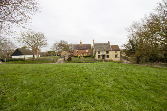
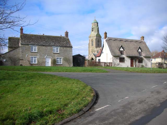
Keyston is a small village located in the district of Huntingdonshire, Cambridgeshire, England. Situated approximately 12 miles to the west of Huntingdon, Keyston is a rural settlement nestled amidst the picturesque countryside. The village is home to a population of around 150 residents, creating a tight-knit community atmosphere.

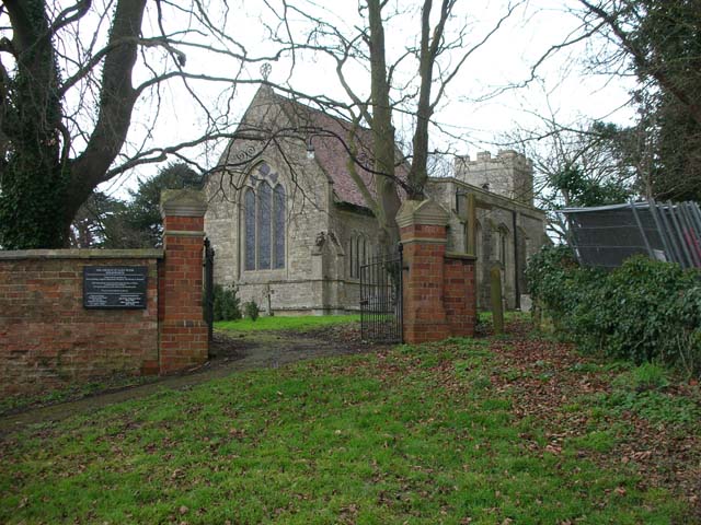
The history of Keyston dates back to medieval times, with evidence of human occupation in the area since the Roman era. The village is characterized by its traditional architecture, with many historic buildings still standing, including the Grade I listed All Saints Church, which dates back to the 13th century. The church is renowned for its beautiful stained glass windows and intricate woodwork.

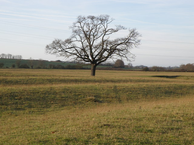
Agriculture plays a significant role in the economy of Keyston, with the surrounding fields primarily used for arable farming and livestock grazing. The village is surrounded by expansive farmland, providing a scenic countryside backdrop and offering opportunities for outdoor activities such as walking and cycling.

Keyston benefits from its proximity to nearby towns and cities, with Huntingdon and Cambridge both easily accessible. Residents can enjoy the peace and tranquility of village life while still having access to modern amenities and services.

Overall, Keyston is a charming village with a rich history, idyllic countryside scenery, and a strong sense of community. It offers a peaceful retreat from the bustle of urban life, making it an attractive place to live or visit for those seeking a rural English experience.

If you have any feedback on the listing, please let us know in the comments section below.

Keyston Images

Images are sourced within 2km of 52.364588/-0.467657 or Grid Reference TL0475. Thanks to Geograph Open Source API. All images are credited.

A14 lay-by
A14 lay-by
Main Street
Main Street
Layby on the A14 east of Thrapston
The A14 east of Thrapston
Stationary traffic on the A14 westbound at Bythorn Traffic was moving extremely slowly past the junction with the B663 at the top of the hill, where a collision between two lorries had closed one lane.
Stationary traffic on the A14 westbound at Bythorn
Traffic was moving extremely slowly past the junction with the B663 at the top of the hill, where a collision between two lorries had closed one lane.
The A14, Bythorn The A14 is a major road which runs for 129 miles from the Port of Felixstowe to the Catthorpe Interchange, the junction of the M1 and M6 motorways near Rugby.

The route linking Rugby (and therefore the West Midlands and the north of England via the motorway network) to East Anglia and the ports of Felixstowe and Harwich is incredibly important and incredibly busy (Felixstowe is the UK's principal container port and the A14 is the road between Felixstowe and everywhere else) but it didn't exist in any coherent form until about 1992.

Prior to the current A14 the main route from Birmingham to the Haven ports followed the old A45 road via Coventry, Rugby, Northampton, St Neots, Cambridge and then through all the towns on the A14, from there to Ipswich where it ended on the A12 – not the fast route required for transporting goods across the country with the sudden rise in container shipping during the latter part of the twentieth century.

Most of the current A14 route is a collection of bits of dual carriageway acquired from other roads (most notably the A45) with occasional stretches of new road to bolt it all together. Because of its importance to the country’s economy, there are plans to upgrade it further.

Prior to its use for the current route the A14 designation had been used for a section of road between the A10 at Royston and the A1 at Alconbury following part of the route of the Roman road, Ermine Street, which is now mostly designated as the A1198. The only bit of the current A14 that follows that number's original route is the spur linking junction 23 to the A1.

<span class="nowrap"><a title="http://www.cbrd.co.uk/motorway/a14" rel="nofollow ugc noopener" href="http://www.cbrd.co.uk/motorway/a14">Link</a><img style="margin-left:2px;" alt="External link" title="External link - shift click to open in new window" src="https://s1.geograph.org.uk/img/external.png" width="10" height="10"/></span> Chris's British Road Directory
<span class="nowrap"><a title="http://en.wikipedia.org/wiki/A14_road_(England)" rel="nofollow ugc noopener" href="http://en.wikipedia.org/wiki/A14_road_(England)">Link</a><img style="margin-left:2px;" alt="External link" title="External link - shift click to open in new window" src="https://s1.geograph.org.uk/img/external.png" width="10" height="10"/></span>  Wikipedia
The A14, Bythorn
The A14 is a major road which runs for 129 miles from the Port of Felixstowe to the Catthorpe Interchange, the junction of the M1 and M6 motorways near Rugby. The route linking Rugby (and therefore the West Midlands and the north of England via the motorway network) to East Anglia and the ports of Felixstowe and Harwich is incredibly important and incredibly busy (Felixstowe is the UK's principal container port and the A14 is the road between Felixstowe and everywhere else) but it didn't exist in any coherent form until about 1992. Prior to the current A14 the main route from Birmingham to the Haven ports followed the old A45 road via Coventry, Rugby, Northampton, St Neots, Cambridge and then through all the towns on the A14, from there to Ipswich where it ended on the A12 – not the fast route required for transporting goods across the country with the sudden rise in container shipping during the latter part of the twentieth century. Most of the current A14 route is a collection of bits of dual carriageway acquired from other roads (most notably the A45) with occasional stretches of new road to bolt it all together. Because of its importance to the country’s economy, there are plans to upgrade it further. Prior to its use for the current route the A14 designation had been used for a section of road between the A10 at Royston and the A1 at Alconbury following part of the route of the Roman road, Ermine Street, which is now mostly designated as the A1198. The only bit of the current A14 that follows that number's original route is the spur linking junction 23 to the A1. LinkExternal link Chris's British Road Directory LinkExternal link Wikipedia
Fields by the A14, Bythorn
Layby on the A14 east of Thrapston Here is an earlier visit. <a title="https://www.geograph.org.uk/photo/7178747" href="https://www.geograph.org.uk/photo/7178747">Link</a>
Layby on the A14 east of Thrapston
Here is an earlier visit. Link
Lorry parked on the A14 east of Thrapston The A14 is a major road which runs for 129 miles from the Port of Felixstowe to the Catthorpe Interchange, the junction of the M1 and M6 motorways near Rugby.

The route linking Rugby (and therefore the West Midlands and the north of England via the motorway network) to East Anglia and the ports of Felixstowe and Harwich is incredibly important and incredibly busy (Felixstowe is the UK's principal container port and the A14 is the road between Felixstowe and everywhere else) but it didn't exist in any coherent form until about 1992.

Prior to the current A14 the main route from Birmingham to the Haven ports followed the old A45 road via Coventry, Rugby, Northampton, St Neots, Cambridge and then through all the towns on the A14, from there to Ipswich where it ended on the A12 – not the fast route required for transporting goods across the country with the sudden rise in container shipping during the latter part of the twentieth century.

Most of the current A14 route is a collection of bits of dual carriageway acquired from other roads (most notably the A45) with occasional stretches of new road to bolt it all together. Because of its importance to the country’s economy, there are plans to upgrade it further.

Prior to its use for the current route the A14 designation had been used for a section of road between the A10 at Royston and the A1 at Alconbury following part of the route of the Roman road, Ermine Street, which is now mostly designated as the A1198. The only bit of the current A14 that follows that number's original route is the spur linking junction 23 to the A1.

<span class="nowrap"><a title="http://www.cbrd.co.uk/motorway/a14" rel="nofollow ugc noopener" href="http://www.cbrd.co.uk/motorway/a14">Link</a><img style="margin-left:2px;" alt="External link" title="External link - shift click to open in new window" src="https://s1.geograph.org.uk/img/external.png" width="10" height="10"/></span> Chris's British Road Directory
<span class="nowrap"><a title="http://en.wikipedia.org/wiki/A14_road_(England)" rel="nofollow ugc noopener" href="http://en.wikipedia.org/wiki/A14_road_(England)">Link</a><img style="margin-left:2px;" alt="External link" title="External link - shift click to open in new window" src="https://s1.geograph.org.uk/img/external.png" width="10" height="10"/></span>  Wikipedia
Lorry parked on the A14 east of Thrapston
The A14 is a major road which runs for 129 miles from the Port of Felixstowe to the Catthorpe Interchange, the junction of the M1 and M6 motorways near Rugby. The route linking Rugby (and therefore the West Midlands and the north of England via the motorway network) to East Anglia and the ports of Felixstowe and Harwich is incredibly important and incredibly busy (Felixstowe is the UK's principal container port and the A14 is the road between Felixstowe and everywhere else) but it didn't exist in any coherent form until about 1992. Prior to the current A14 the main route from Birmingham to the Haven ports followed the old A45 road via Coventry, Rugby, Northampton, St Neots, Cambridge and then through all the towns on the A14, from there to Ipswich where it ended on the A12 – not the fast route required for transporting goods across the country with the sudden rise in container shipping during the latter part of the twentieth century. Most of the current A14 route is a collection of bits of dual carriageway acquired from other roads (most notably the A45) with occasional stretches of new road to bolt it all together. Because of its importance to the country’s economy, there are plans to upgrade it further. Prior to its use for the current route the A14 designation had been used for a section of road between the A10 at Royston and the A1 at Alconbury following part of the route of the Roman road, Ermine Street, which is now mostly designated as the A1198. The only bit of the current A14 that follows that number's original route is the spur linking junction 23 to the A1. LinkExternal link Chris's British Road Directory LinkExternal link Wikipedia
Leaf information boards by the bridleway The public are well served with information boards about the approach to environmental farming on this particular farm. <span class="nowrap"><a title="http://www.leafuk.org/leaf/home.eb" rel="nofollow ugc noopener" href="http://www.leafuk.org/leaf/home.eb">Link</a><img style="margin-left:2px;" alt="External link" title="External link - shift click to open in new window" src="https://s1.geograph.org.uk/img/external.png" width="10" height="10"/></span>
Leaf information boards by the bridleway
The public are well served with information boards about the approach to environmental farming on this particular farm. LinkExternal link
Clack Barn Track leading up to Clack Barn on Mickle Hill ridge.
Clack Barn
Track leading up to Clack Barn on Mickle Hill ridge.
A stand of Poplar trees If felled will probably only be useful for composite boards.
A stand of Poplar trees
If felled will probably only be useful for composite boards.
A view from Clack Barns Primarily arable farming country with pockets of sheep and beef farms around the villages using old ridge and furrow pastures.
A view from Clack Barns
Primarily arable farming country with pockets of sheep and beef farms around the villages using old ridge and furrow pastures.
Clack lane Clack Lane towards Bythorn, a bridleway and farm access track.
Clack lane
Clack Lane towards Bythorn, a bridleway and farm access track.
Sheep feeders by Clack Lane A large acreage of Ridge and Furrow land lies by the A14 to the south of Bythorn therefore making good sheep grazing pastures.
Sheep feeders by Clack Lane
A large acreage of Ridge and Furrow land lies by the A14 to the south of Bythorn therefore making good sheep grazing pastures.
A solitary Oak tree in the ridge and furrow Farm land to the south of Bythorn has a good show of the historical ridge and furrow farming system. Next time your passing Bythorn west bound on the A14 look to your left and you'll see it, passengers only please.
A solitary Oak tree in the ridge and furrow
Farm land to the south of Bythorn has a good show of the historical ridge and furrow farming system. Next time your passing Bythorn west bound on the A14 look to your left and you'll see it, passengers only please.
Show me another place!

Keyston is located at Grid Ref: TL0475 (Lat: 52.364588, Lng: -0.467657)

Administrative County: Cambridgeshire

District: Huntingdonshire

Police Authority: Cambridgeshire

What 3 Words

///beanbag.revisits.grudge. Near Raunds, Northamptonshire

Related Wikis

Keyston

Keyston is a village and former civil parish, now in the parish of Bythorn and Keyston, in Cambridgeshire, England. Keyston lies approximately 12 miles...

Bythorn and Keyston

Bythorn and Keyston is a civil parish in the Huntingdonshire district of Cambridgeshire, England. According to the 2001 census the parish had a population...

Bythorn

Bythorn is a village and former civil parish, now in the parish of Bythorn and Keyston, in Cambridgeshire, England. Bythorn lies approximately 11 miles...

Molesworth, Cambridgeshire

Molesworth is a village and former civil parish, now in the parish of Brington and Molesworth in Cambridgeshire, England. Molesworth is 10 miles (16 km...

Nearby Amenities

Located within 500m of 52.364588,-0.467657
Created By: Merkaartor 0.12
Lat/Long: 52.365248/-0.468909
Created By: Merkaartor 0.12
Lat/Long: 52.3650229/-0.468531
Created By: Merkaartor 0.12
Lat/Long: 52.3647841/-0.4679542
Created By: Merkaartor 0.12
Lat/Long: 52.3642469/-0.4674231
Created By: Merkaartor 0.12
Lat/Long: 52.365762/-0.4692909
Created By: Merkaartor 0.12
Lat/Long: 52.365911/-0.4692685
Telephone
Booth: K6
Covered: booth
Listed Status: Grade II
Operator: BT
Phone: +44 1832 710279
Source: survey
Lat/Long: 52.3676173/-0.467805
Post Box
Brand: Royal Mail
Brand Wikidata: Q638098
Brand Wikipedia: en:Royal Mail
Collection Times: Mo-Fr 09:00; Sa 07:00
Operator: Royal Mail
Operator Wikidata: Q638098
Post Box Type: lamp
Ref: PE28 43
Royal Cypher: EIIR
Royal Cypher Wikidata: Q33102113
Source: survey
Lat/Long: 52.3675961/-0.4677406
Keyston
Created By: Merkaartor 0.12
Place: village
Source: survey
Wikidata: Q6398419
Lat/Long: 52.3662058/-0.4684638
Created By: Merkaartor 0.12
Lat/Long: 52.36615/-0.4675909
Created By: Merkaartor 0.12
Lat/Long: 52.365888/-0.4674178
Created By: Merkaartor 0.12
Lat/Long: 52.365436/-0.4669081
Created By: Merkaartor 0.12
Lat/Long: 52.3651543/-0.4667311
Created By: Merkaartor 0.12
Lat/Long: 52.3649086/-0.4667472
Created By: Merkaartor 0.12
Lat/Long: 52.3636933/-0.4678362
Created By: Merkaartor 0.12
Lat/Long: 52.3625039/-0.46888
Created By: Merkaartor 0.12
Lat/Long: 52.3614625/-0.4700034
Bus Stop
Church View
Bus: yes
Naptan AtcoCode: 0500HBYTH001
Naptan Bearing: N
Naptan BusStopType: CUS
Naptan CommonName: Church View
Naptan Indicator: opp
Naptan Landmark: Church View
Naptan NaptanCode: cmbdmtwa
Naptan ShortCommonName: Church View
Naptan Street: Loop Road
Naptan Verified: no
Public Transport: platform
Source: naptan_import
Lat/Long: 52.3656995/-0.4699013
Bus Stop
Church View
Bus: yes
Naptan AtcoCode: 0500HBYTH004
Naptan Bearing: SE
Naptan BusStopType: CUS
Naptan CommonName: Church View
Naptan Indicator: near
Naptan Landmark: Church View
Naptan NaptanCode: cmbdmtwj
Naptan ShortCommonName: Church View
Naptan Street: Loop Road
Naptan Verified: no
Public Transport: platform
Source: naptan_import
Lat/Long: 52.3657253/-0.4698123
Power: transformer
Lat/Long: 52.3667564/-0.4636308
Power: pole
Lat/Long: 52.3666874/-0.4656049
Power: pole
Lat/Long: 52.3666547/-0.4666348
Power: transformer
Lat/Long: 52.3666154/-0.4676272
Power: pole
Lat/Long: 52.3667267/-0.4645749
Power: pole
Lat/Long: 52.3668463/-0.4614393
Power: pole
Lat/Long: 52.366791/-0.4625085
Power: pole
Lat/Long: 52.363225/-0.4677989
Power: pole
Lat/Long: 52.3627238/-0.4682388
Power: pole
Lat/Long: 52.3605224/-0.4706635
Power: pole
Lat/Long: 52.3622275/-0.468684
Power: pole
Lat/Long: 52.3611808/-0.4696201
Barrier: stile
Lat/Long: 52.3622931/-0.4692125
The data included in this document is from www.openstreetmap.org. The data is made available under ODbL.

Have you been to Keyston?

Leave your review of Keyston below (or comments, questions and feedback).