Birky Hill

Hill, Mountain in Northumberland

England

Birky Hill

Spylaw Cottage An old cottage previously occupied by a shepherd and his family. At the time that the photograph was taken [1964] the cottage was rented by the Scout Mountaineering Club.
Spylaw Cottage Credit: Phil Thirkell

Birky Hill is a prominent hill located in the county of Northumberland, England. Situated near the North Pennines Area of Outstanding Natural Beauty, it forms part of the picturesque landscape that characterizes the region. The hill stands at an elevation of approximately 524 meters (1,719 feet) above sea level, making it one of the notable peaks in the area.

Birky Hill offers breathtaking panoramic views of the surrounding countryside, providing visitors with a stunning vista of the Northumberland landscape. The hill is covered in lush greenery, with scattered patches of heather and small shrubs accentuating its natural beauty. The terrain is generally gentle, although some areas may be steeper and more challenging to navigate.

The hill is a popular destination for outdoor enthusiasts, particularly hikers and walkers, who are drawn to its scenic trails and peaceful ambiance. There are several well-marked paths leading to the summit, catering to a range of skill levels. Along the way, visitors may encounter a variety of wildlife, including birds, rabbits, and occasional deer, adding to the overall allure of the area.

Aside from its natural appeal, Birky Hill also holds historical significance. The remains of an Iron Age hillfort can be found on its slopes, serving as a reminder of the region's ancient past. These archaeological features contribute to the hill's cultural value and attract history enthusiasts keen on exploring the site.

Overall, Birky Hill is a captivating destination that offers a blend of natural beauty, recreational opportunities, and historical interest. Whether it be for a leisurely stroll or a challenging hike, visitors are sure to find solace and inspiration in the tranquility of this Northumberland landmark.

If you have any feedback on the listing, please let us know in the comments section below.

Birky Hill Images

Images are sourced within 2km of 55.285958/-1.923737 or Grid Reference NZ0499. Thanks to Geograph Open Source API. All images are credited.

Spylaw Cottage An old cottage previously occupied by a shepherd and his family. At the time that the photograph was taken [1964] the cottage was rented by the Scout Mountaineering Club.
Spylaw Cottage
An old cottage previously occupied by a shepherd and his family. At the time that the photograph was taken [1964] the cottage was rented by the Scout Mountaineering Club.
The path to Simonside The path leaves the car park for the ascent of this striking hill.
The path to Simonside
The path leaves the car park for the ascent of this striking hill.
The slopes of the Simonside Hills Looking up towards the Beacon <a href="https://www.geograph.org.uk/gridref/NZ1498">NZ1498</a>, the easternmost summit.
The slopes of the Simonside Hills
Looking up towards the Beacon NZ1498, the easternmost summit.
Path below the Simonside Hills Garleigh Hill <a href="https://www.geograph.org.uk/gridref/NZ0699">NZ0699</a> on the skyline.
Path below the Simonside Hills
Garleigh Hill NZ0699 on the skyline.
Kitty Thrist's Well The well lies in the midst of the bushes centre foreground.  View down the Coquet Valley to the coast.
Kitty Thrist's Well
The well lies in the midst of the bushes centre foreground. View down the Coquet Valley to the coast.
Kitty Thrist's Well The well is now little more than a swampy area in the midst of bushes.  Presumably it was much more grand in its heyday.  Water was very clear; didn't taste it.
Kitty Thrist's Well
The well is now little more than a swampy area in the midst of bushes. Presumably it was much more grand in its heyday. Water was very clear; didn't taste it.
Storm Arwen devastation Reminiscent of Tunguska, there's not much left of the small area of forestry either side of the road at Lordenshaw.  As well as the many trees uprooted a large number have been simply snapped off by the storm's ferocity.
Storm Arwen devastation
Reminiscent of Tunguska, there's not much left of the small area of forestry either side of the road at Lordenshaw. As well as the many trees uprooted a large number have been simply snapped off by the storm's ferocity.
Summit ridge on the Simonside Hills Old Stell Crag in the middle distance.
Summit ridge on the Simonside Hills
Old Stell Crag in the middle distance.
Path closure in the Simonside Hills Because of the erosion due to the immense popularity of the Simonside Hills amongst walkers, the National Park have been compelled to close the permissive path that ran just below Dove Crag. As an alternative, the National Park has established a flagged path along the whole length of the ridge.
Path closure in the Simonside Hills
Because of the erosion due to the immense popularity of the Simonside Hills amongst walkers, the National Park have been compelled to close the permissive path that ran just below Dove Crag. As an alternative, the National Park has established a flagged path along the whole length of the ridge.
Summit ridge on the Simonside Hills Seen from Dove Crag, the escarpment of the Simonside Hills. The nearest summit (to the left) is Old Stell Crag. Simonside (the highest point on the ridge) is visible as a small pimple at the far end.
Summit ridge on the Simonside Hills
Seen from Dove Crag, the escarpment of the Simonside Hills. The nearest summit (to the left) is Old Stell Crag. Simonside (the highest point on the ridge) is visible as a small pimple at the far end.
Simonside Forest Looking down from the summit of Dove Crag.
Simonside Forest
Looking down from the summit of Dove Crag.
Stopping for a chat On the summit of Dove Crag. Simonside Forest in the middle distance, with the Cheviot Hills on the skyline.
Stopping for a chat
On the summit of Dove Crag. Simonside Forest in the middle distance, with the Cheviot Hills on the skyline.
Gate on the path The path runs along the summit ridge of the Simonside Hills.
Gate on the path
The path runs along the summit ridge of the Simonside Hills.
Windthrow in Simonside Forest Vast numbers of trees were blown down by Storm Arwen on 8th December 2021. Further up the hill, fallen trees still block this forest road in large numbers (see <a href="https://www.geograph.org.uk/photo/7071358">NZ0299 : Windthrow in Simonside Forest</a>), but have been cleared from this lower stretch of road as it is required to give access to the TV aerial mast serving Rothbury (see <a href="https://www.geograph.org.uk/photo/826174">NZ0399 : Communications Mast on Simonside</a>).
Windthrow in Simonside Forest
Vast numbers of trees were blown down by Storm Arwen on 8th December 2021. Further up the hill, fallen trees still block this forest road in large numbers (see NZ0299 : Windthrow in Simonside Forest), but have been cleared from this lower stretch of road as it is required to give access to the TV aerial mast serving Rothbury (see NZ0399 : Communications Mast on Simonside).
Information point, Simonside Forest At the car park (currently closed) at the lower end of Simonside Forest.
Information point, Simonside Forest
At the car park (currently closed) at the lower end of Simonside Forest.
Waiting for the dog poo fairy to collect The dog walkers who frequent these forest walks have dutifully collected dog poo in their little bags. But why on earth do they think that it is then acceptable to make a neat little pile of their offerings at the car park instead of taking them home and disposing of them there.
Waiting for the dog poo fairy to collect
The dog walkers who frequent these forest walks have dutifully collected dog poo in their little bags. But why on earth do they think that it is then acceptable to make a neat little pile of their offerings at the car park instead of taking them home and disposing of them there.
Car park closed The car park at Simonside Forest has been closed after Storm Arwen on 8th December, 2021 in a not altogether successful attempt to deter visitors to the heavily storm-damaged forest.
Car park closed
The car park at Simonside Forest has been closed after Storm Arwen on 8th December, 2021 in a not altogether successful attempt to deter visitors to the heavily storm-damaged forest.
Show me another place!

Birky Hill is located at Grid Ref: NZ0499 (Lat: 55.285958, Lng: -1.923737)

Unitary Authority: Northumberland

Police Authority: Northumbria

What 3 Words

///posed.travel.dolly. Near Rothbury, Northumberland

Nearby Locations

Birky Hill Newtown Park

Related Wikis

Rothbury Community Hospital

Rothbury Community Hospital in Rothbury, Northumberland, England, is managed by the Northumbria Healthcare NHS Foundation Trust. == History == === Prior... ===

Simonside Hills

The Simonside Hills are a hill range in Northumberland, England near the town of Rothbury. Most of the hills are around 300–400 metres (980–1,310 ft) high...

Rothbury

Rothbury is a market town and civil parish in Northumberland, England, on the River Coquet. It is 14 miles (22.5 km) northwest of Morpeth and 26 miles...

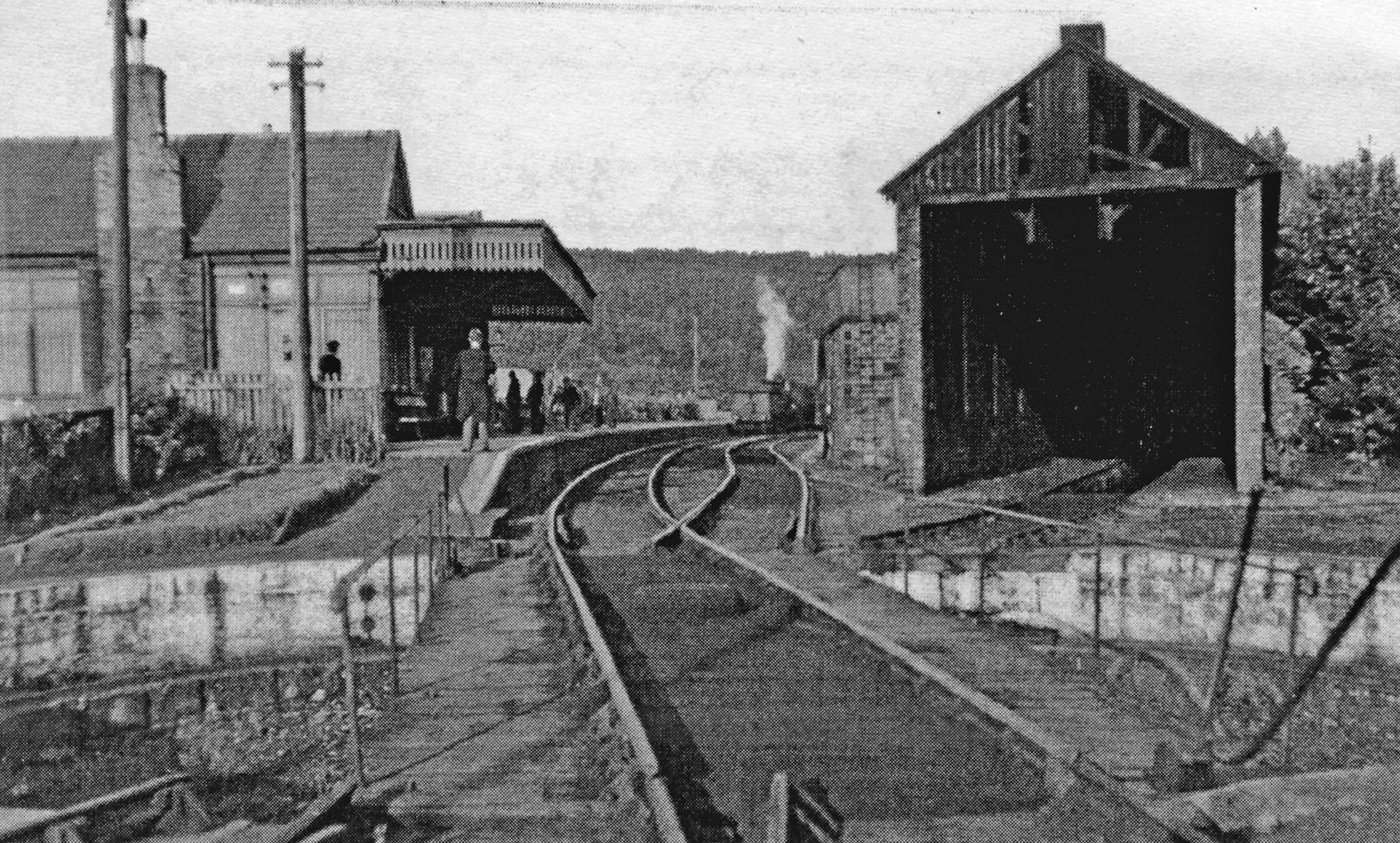
Rothbury railway station

Rothbury was a railway station in Northumberland, England at the end of the single-track Rothbury Branch that served the town of Rothbury. Rothbury was...

Thrum Mill, Rothbury, Northumberland

The Thrum Mill is a grade II-listed water mill in Rothbury, Northumberland, England. The water mill dates back to 1665. == Media == The renovation of Thrum...

Hesleyhurst

Hesleyhurst is a civil parish in the county of Northumberland in England. At the 2011 Census the population was only minimal. It is served by a joint parish...

Thropton

Thropton is a hamlet in Northumberland, England, located on the River Coquet, and its tributary Wreigh Burn. With a population of 458 (2011 census) it...

Brinkburn railway station

Brinkburn was a weatherboard- and corrugated-iron-built railway station in Northumberland on the Rothbury Branch built to serve the Healy Coate Colliery...

Nearby Amenities

Located within 500m of 55.285958,-1.923737
Footpath, St Oswalds Way, Rock Art
Information: guidepost
Tourism: information
Lat/Long: 55.2835111/-1.9183508
Footpath, St Oswalds Way, Rock Art
Information: guidepost
Tourism: information
Lat/Long: 55.2857733/-1.9176708
Cup and Ring marked rock
Board Type: history
Description: This cup and ring marked rock is protected as a monument of national importance under the Ancient Monuments Acts 1913-53
Information: board
Tourism: information
Lat/Long: 55.2865004/-1.9192198
Footpath, St Oswalds Way, Rock Art
Information: guidepost
Tourism: information
Lat/Long: 55.2869776/-1.9179521
The data included in this document is from www.openstreetmap.org. The data is made available under ODbL.

Have you been to Birky Hill?

Leave your review of Birky Hill below (or comments, questions and feedback).