Calfclose Hill

Hill, Mountain in Durham

England

Calfclose Hill

Derwent Reservoir from Muggleswick Park
Derwent Reservoir from Muggleswick Park Credit: Clive Nicholson

Calfclose Hill is a prominent hill situated in County Durham, England. It is located near the village of Edmundbyers, approximately 10 miles southwest of Consett. Standing at an elevation of 1,458 feet (444 meters), Calfclose Hill is classified as a Marilyn, which means it meets the criteria of having a prominence of at least 150 meters (492 feet) relative to its surrounding landscape.

The hill is characterized by its distinctive conical shape, with a grassy terrain covering its slopes. It is part of the North Pennines Area of Outstanding Natural Beauty, offering stunning panoramic views of the surrounding countryside. On a clear day, visitors can see as far as the Cheviot Hills to the north and even the Lake District peaks to the west.

Calfclose Hill is a popular destination for hikers and nature enthusiasts, attracting both locals and tourists alike. There are various walking trails leading up to the summit, providing different levels of challenge depending on one's fitness and experience. The ascent to the top rewards climbers with breathtaking vistas and a sense of accomplishment.

The hill is also home to a diverse range of flora and fauna, with heather, grasses, and wildflowers painting the landscape in vibrant colors during the summer months. The area is rich in wildlife, including birds such as curlews and grouse, as well as numerous species of butterflies and moths.

Overall, Calfclose Hill is a picturesque and accessible hill in Durham, offering outdoor enthusiasts an opportunity to connect with nature and enjoy the beauty of the North Pennines.

If you have any feedback on the listing, please let us know in the comments section below.

Calfclose Hill Images

Images are sourced within 2km of 54.831771/-1.9325474 or Grid Reference NZ0448. Thanks to Geograph Open Source API. All images are credited.
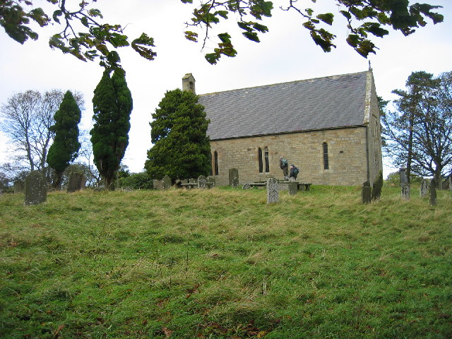
Derwent Reservoir from Muggleswick Park
Muggleswick Village
Muggleswick Village
Crooked Oak At the end of the road
Crooked Oak
At the end of the road
Looking west towards Edmundbyers
Muggleswick Monastic Grange Keys to the Past Web Site
These are the remains of a monastic grange built between 1258 and 1272 on what is thought to be site of earlier grange. In 1464 site consisted of a hall, chapel, grange and dairy, the latter in poor state of repair.
Visible remains include two rectangular buildings. The eastern block stands to complete height of nearly 16m at the eastern end but is elsewhere much lower. 
Western block survives to 4m at western end but is not visible on surface elsewhere although foundations are thought to survive underground. This building had an undercroft that was at least partly removed in 19th century.
Muggleswick Monastic Grange
Keys to the Past Web Site These are the remains of a monastic grange built between 1258 and 1272 on what is thought to be site of earlier grange. In 1464 site consisted of a hall, chapel, grange and dairy, the latter in poor state of repair. Visible remains include two rectangular buildings. The eastern block stands to complete height of nearly 16m at the eastern end but is elsewhere much lower. Western block survives to 4m at western end but is not visible on surface elsewhere although foundations are thought to survive underground. This building had an undercroft that was at least partly removed in 19th century.
Muggleswick Monastic Grange Impressive fireplace.
Muggleswick Monastic Grange
Impressive fireplace.
Muggleswick All Saints Church The Church is a plain stone structure, which was rebuilt about the year 1728, on the site of the former church, whose materials were chiefly used in the construction of the present edifice. The parish register commences in 1730. The living is a perpetual curacy, a peculiar of the dean and chapter of Durham, and pays no first fruits or tenths. The parish is free of tithes, except a portion of Cold Rowley and Muggleswick, which produces about £34 per annum: the remainder of the income of the living is derived from farm-rents in the parish. Patrons, the dean and chapter; incumbent, the Rev. Cundhill. [Whellan's History, Topography and Directory of Durham (and Newcastle) (1856), page 905.]
Muggleswick All Saints Church
The Church is a plain stone structure, which was rebuilt about the year 1728, on the site of the former church, whose materials were chiefly used in the construction of the present edifice. The parish register commences in 1730. The living is a perpetual curacy, a peculiar of the dean and chapter of Durham, and pays no first fruits or tenths. The parish is free of tithes, except a portion of Cold Rowley and Muggleswick, which produces about £34 per annum: the remainder of the income of the living is derived from farm-rents in the parish. Patrons, the dean and chapter; incumbent, the Rev. Cundhill. [Whellan's History, Topography and Directory of Durham (and Newcastle) (1856), page 905.]
Muggleswick All Saints Church
Catchwater Channel on Muggleswick Common Catchwater channel leading to Hisehope Reservoir. Obviously overgrown and having long out-lived their purpose.  A series of footbridges which are wide enough to accommodate a vehicle are placed at regular intervals along the channel.
Catchwater Channel on Muggleswick Common
Catchwater channel leading to Hisehope Reservoir. Obviously overgrown and having long out-lived their purpose. A series of footbridges which are wide enough to accommodate a vehicle are placed at regular intervals along the channel.
Footpath on Muggleswick Common Footpath leading from Smiddy Shaw reservoir to Lamb Shield Farm
Footpath on Muggleswick Common
Footpath leading from Smiddy Shaw reservoir to Lamb Shield Farm
Farmland and the remains of a house? On 1:25000 map Hisefield House is marked.  Cannot find any other reference than Hisefield House, although on old maps area called Harefield or Horsefield.  These piles of stones aren't consistent with piles of stones one normally finds where houses once stood.
Farmland and the remains of a house?
On 1:25000 map Hisefield House is marked. Cannot find any other reference than Hisefield House, although on old maps area called Harefield or Horsefield. These piles of stones aren't consistent with piles of stones one normally finds where houses once stood.
Road Junction near Muggleswick The road junction below Muggleswick Park with views of Derwent Reservoir in the distance.
Road Junction near Muggleswick
The road junction below Muggleswick Park with views of Derwent Reservoir in the distance.
Pill Box Pill Box below Muggleswick Park.
Would love to hear the history of this !
Pill Box
Pill Box below Muggleswick Park. Would love to hear the history of this !
No Parking Bit difficult to park never mind the signpost!
No Parking
Bit difficult to park never mind the signpost!
Coal Gate Road
Coal Gate Road
Hairpin or Roundabout? If you think this is a sharp bend, keep travelling downhill.
Hairpin or Roundabout?
If you think this is a sharp bend, keep travelling downhill.
Hairpin and Kiln The remains of what appears to be a limekiln is well nestled into this hairpin bend.
Hairpin and Kiln
The remains of what appears to be a limekiln is well nestled into this hairpin bend.
Cattle Grid
Cattle Grid
Show me another place!

Calfclose Hill is located at Grid Ref: NZ0448 (Lat: 54.831771, Lng: -1.9325474)

Unitary Authority: County Durham

Police Authority: Durham

What 3 Words

///novels.signed.immediate. Near Muggleswick, Co. Durham

Related Wikis

Derwent Gorge and Horsleyhope Ravine

Derwent Gorge and Horsleyhope Ravine is a Site of Special Scientific Interest in the Derwentside district of north County Durham and the Tynedale district...

Hisehope Burn Valley

Hisehope Burn Valley is a Site of Special Scientific Interest in the Derwentside district of Durham, England. It consists of two separate parcels of land...

Muggleswick

Muggleswick is a village and civil parish in County Durham, England. It is situated a few miles to the west of Consett. the population was 130 at the 2001...

Healeyfield

Healeyfield is a village and civil parish in County Durham, England. The population of the civil parish taken from the 2011 census was 1,544. It is situated...

Nearby Amenities

Located within 500m of 54.831771,-1.9325474
Barrier: cattle_grid
Bicycle: yes
Foot: yes
Image: https://www.geograph.org.uk/photo/542563
Motorcar: yes
Motorcycle: yes
Lat/Long: 54.8327577/-1.9308646
Barrier: cattle_grid
Lat/Long: 54.8322596/-1.9352928
Barrier: stile
Foot: yes
Stile: ladder
Lat/Long: 54.8351655/-1.9298245
Hiking: yes
Information: guidepost
Tourism: information
Lat/Long: 54.8329882/-1.9311422
Coal Gate
Place: locality
Source Name: OS_OpenData_StreetView
Lat/Long: 54.8318636/-1.935946
The data included in this document is from www.openstreetmap.org. The data is made available under ODbL.

Have you been to Calfclose Hill?

Leave your review of Calfclose Hill below (or comments, questions and feedback).