Bonny Hill

Hill, Mountain in Yorkshire

England

Bonny Hill

Remains of Doe Park Mill
Remains of Doe Park Mill Credit: Clive Nicholson

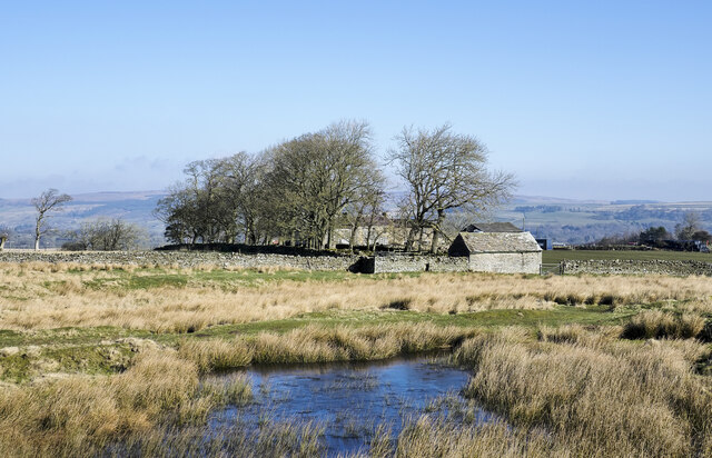
Bonny Hill is a picturesque hill located in the charming county of Yorkshire, England. Rising to a height of approximately 300 meters, it is often referred to as a hill rather than a mountain due to its moderate elevation. The hill is nestled within the rolling Yorkshire Dales, offering visitors breathtaking panoramic views of the surrounding countryside.

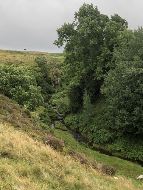
Covered in lush green grass and dotted with vibrant wildflowers during the summer months, Bonny Hill is a haven for nature lovers and outdoor enthusiasts. The hill boasts a diverse range of flora and fauna, including heather, gorse, and various species of birds and butterflies.

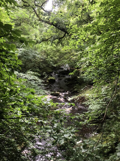
A network of well-maintained footpaths crisscrosses the hill, making it easily accessible for hikers and walkers of all abilities. These paths lead visitors through peaceful woodlands, along babbling brooks, and up to the summit, where they can admire the sweeping vistas of the Yorkshire Dales.

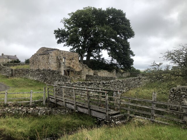
Bonny Hill is also steeped in history, with remnants of ancient settlements and landmarks scattered across its slopes. Archaeological discoveries have revealed traces of human activity dating back thousands of years, providing insight into the area's rich cultural heritage.

The hill is a popular destination for locals and tourists alike, offering a tranquil escape from the hustle and bustle of city life. Whether it's a leisurely stroll or a challenging hike, Bonny Hill promises a serene and captivating experience, leaving visitors with a deep appreciation for Yorkshire's natural beauty.

If you have any feedback on the listing, please let us know in the comments section below.

Bonny Hill Images

Images are sourced within 2km of 54.56858/-2.0146916 or Grid Reference NY9919. Thanks to Geograph Open Source API. All images are credited.

Remains of Doe Park Mill
Ruins of former mill Balder mill or Doe Park mill was used until the construction of reservoirs upstream interrupted the water supply.
Ruins of former mill
Balder mill or Doe Park mill was used until the construction of reservoirs upstream interrupted the water supply.
Entrance to Cotherstone
The B6277 crossing Wilden Bridge
Moorland with partly frozen pool The pool is beside a moorland track, south of farms at Booze Wood and High Corn Park, which is the set of buildings beyond the trees.
Moorland with partly frozen pool
The pool is beside a moorland track, south of farms at Booze Wood and High Corn Park, which is the set of buildings beyond the trees.
Remains of World War II tank The remains of the tank lie on moorland north of the MOD Battle Hill Range and south-west of the trig point of Currack Rigg. An item in the Northern Echo of 03 January 2021, tells that this is the wreckage of a Valentine Mk III, Second World War tank built by Vickers-Armstrong. However, although an item on Andy Beck's website, (<span class="nowrap"><a title="https://andybeckimages.co.uk/cotherstone-moor/" rel="nofollow ugc noopener" href="https://andybeckimages.co.uk/cotherstone-moor/">Link</a><img style="margin-left:2px;" alt="External link" title="External link - shift click to open in new window" src="https://s1.geograph.org.uk/img/external.png" width="10" height="10"/></span> ), gives that same information, further into the article doubt is cast upon the identification. There are references from the web page to a Wikipedia entry and a comment at the end by one, Dave Middlemas, giving a different origin altogether. Worth reading.
Remains of World War II tank
The remains of the tank lie on moorland north of the MOD Battle Hill Range and south-west of the trig point of Currack Rigg. An item in the Northern Echo of 03 January 2021, tells that this is the wreckage of a Valentine Mk III, Second World War tank built by Vickers-Armstrong. However, although an item on Andy Beck's website, (LinkExternal link ), gives that same information, further into the article doubt is cast upon the identification. There are references from the web page to a Wikipedia entry and a comment at the end by one, Dave Middlemas, giving a different origin altogether. Worth reading.
Moorland beyond trig point of Currack Rigg Heather and grass moorland with rushes around the pillar and beyond to the west.
Loups's Hill is in the distance left of centre, with Goldsborough further away, partly concealed by a block of trees.
Moorland beyond trig point of Currack Rigg
Heather and grass moorland with rushes around the pillar and beyond to the west. Loups's Hill is in the distance left of centre, with Goldsborough further away, partly concealed by a block of trees.
Road rising from North Gill Bridge The bridge itself is out of view but part of the eastern parapet can be seen. The road continues northwards towards the village at Cotherstone.
Road rising from North Gill Bridge
The bridge itself is out of view but part of the eastern parapet can be seen. The road continues northwards towards the village at Cotherstone.
Damaged Scots pine tree in enclosure A recently fallen branch lies on the ground beside the tree which is the same one pictured in an earlier image - <a title="https://www.geograph.org.uk/photo/3675273" href="https://www.geograph.org.uk/photo/3675273">Link</a> . The bough was presumably torn from the tree by  wind, very likely during one of the violent storms of winter 2021 / 2022.
Damaged Scots pine tree in enclosure
A recently fallen branch lies on the ground beside the tree which is the same one pictured in an earlier image - Link . The bough was presumably torn from the tree by wind, very likely during one of the violent storms of winter 2021 / 2022.
View To How Beck Gully
Cattle above North Gill The area between Lartington and the moor edge is mostly given over to livestock production. My guess is that altitude, climate and soil conditions prevent this being a cereal growing area.
Cattle above North Gill
The area between Lartington and the moor edge is mostly given over to livestock production. My guess is that altitude, climate and soil conditions prevent this being a cereal growing area.
Track on to the moor Track and public footpath heading up North Gill into access land that runs for many miles westwards.
Track on to the moor
Track and public footpath heading up North Gill into access land that runs for many miles westwards.
Path across the moor No obvious line through rough grassland and heather here. The path is heading into open access land from the Cotherstone to Bowes road.
Path across the moor
No obvious line through rough grassland and heather here. The path is heading into open access land from the Cotherstone to Bowes road.
Road to Cotherstone Looking north-east with open access land to the left and enclosed fields to the right.
Road to Cotherstone
Looking north-east with open access land to the left and enclosed fields to the right.
The Butter Stone A natural rock, most likely an erratic, sat near the edge of the moor above Cotherstone. As other contributors have said, this was a place where money was left for food supplies during times of plague.
The Butter Stone
A natural rock, most likely an erratic, sat near the edge of the moor above Cotherstone. As other contributors have said, this was a place where money was left for food supplies during times of plague.
Ruins of old chapel, Brisoe The Chapel was in use in the 1700s and is one of the earliest in the North Pennines. It was replaced by a larger building a few hundred yards away in 1905.
Ruins of old chapel, Brisoe
The Chapel was in use in the 1700s and is one of the earliest in the North Pennines. It was replaced by a larger building a few hundred yards away in 1905.
River Balder in wooded valley
How beck in wooded ravine
Show me another place!

Bonny Hill is located at Grid Ref: NY9919 (Lat: 54.56858, Lng: -2.0146916)

Division: North Riding

Unitary Authority: County Durham

Police Authority: Durham

What 3 Words

///fatherly.repeat.incoming. Near Romaldkirk, Co. Durham

Nearby Locations

Bonny Hill

Related Wikis

Baldersdale Woodlands

Baldersdale Woodlands is a Site of Special Scientific Interest in the Teesdale district of south-west County Durham, England. It consists primarily of...

East Briscoe

East Briscoe is a village in Baldersdale, in the Pennines district of County Durham, England. It is traditionally located in the North Riding of Yorkshire...

Hunderthwaite

Hunderthwaite is a village and civil parish in Teesdale, in the Pennines of England. The population of the civil parish taken at the 2011 census was 114...

Cotherstone

Cotherstone is a village and civil parish in the district and county of Durham, England. Its historic county is Yorkshire, being just south of the River...

Nearby Amenities

Located within 500m of 54.56858,-2.0146916
Barrier: entrance
Lat/Long: 54.5654734/-2.0107662
Barrier: entrance
Lat/Long: 54.5646874/-2.0177159
Barrier: entrance
Lat/Long: 54.5661629/-2.0127849
Barrier: entrance
Lat/Long: 54.5661863/-2.0123783
The data included in this document is from www.openstreetmap.org. The data is made available under ODbL.

Have you been to Bonny Hill?

Leave your review of Bonny Hill below (or comments, questions and feedback).