Cleasby Hill

Hill, Mountain in Yorkshire Richmondshire

England

Cleasby Hill

Eroding sandstone on Scargill High Moor The prominent escarpment  at the top of Scargill High Moor is formed in the unnamed sandstone that lies just below the Little Limestone, towards the bottom of the Stainmore Group, of Pendleian age in the Carboniferous. It's part of what older ones among us will remember as being the Millstone Grit series. At the top of the slope, blocks of sandstone are weathering out, and have little or no peat drift covering them. Just back from the edge, a path links lines of grouse butts, making for surprisingly easy and pleasant walking. Even beyond the last grouse butt (some way to the west) the path continues as a gamekeeper's access, somewhat narrower but still giving mostly easy footing.
Eroding sandstone on Scargill High Moor Credit: Andy Waddington

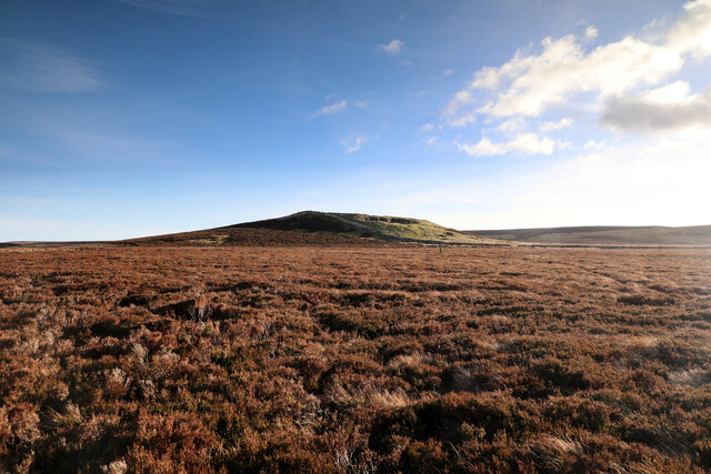
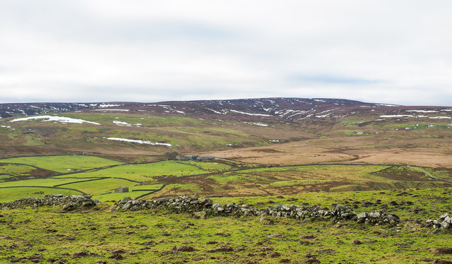
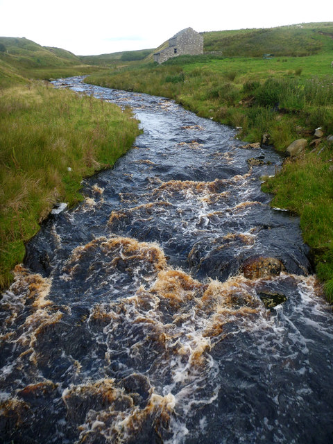
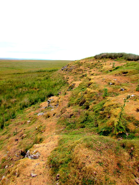
Cleasby Hill is a prominent hill located in the county of Yorkshire, England. Situated near the village of Cleasby, it forms part of the magnificent landscape of the Yorkshire Dales National Park. Rising to an elevation of approximately 355 meters (1,165 feet), Cleasby Hill offers breathtaking panoramic views of the surrounding countryside.

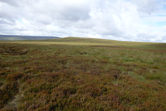
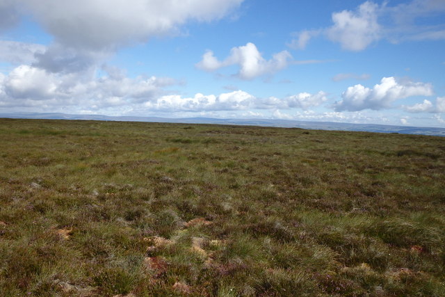
The hill is characterized by its gently sloping sides and rolling terrain, which are covered in lush green grasses and scattered with clusters of trees. This creates a picturesque setting that is ideal for outdoor enthusiasts. Cleasby Hill is a popular destination for hikers, walkers, and nature lovers, who are drawn to its tranquil atmosphere and stunning vistas.

The hill is home to a diverse range of flora and fauna, with wildflowers and heather adorning its slopes during the summer months. Many species of birds can be spotted here, including buzzards, kestrels, and skylarks. The peaceful surroundings also attract various small mammals, such as rabbits and hares.

Aside from its natural beauty, Cleasby Hill also holds historical significance. The area is dotted with ancient ruins and archaeological sites, providing a glimpse into the region's past. It is believed that the hill was once inhabited by early settlers, and remnants of their dwellings can still be found.

Overall, Cleasby Hill offers a captivating blend of natural beauty, historical intrigue, and recreational opportunities. Whether one seeks a peaceful hike, a scenic picnic spot, or an escape into the rich heritage of Yorkshire, this hill is a must-visit destination.

If you have any feedback on the listing, please let us know in the comments section below.

Cleasby Hill Images

Images are sourced within 2km of 54.46547/-2.0335376 or Grid Reference NY9707. Thanks to Geograph Open Source API. All images are credited.

Eroding sandstone on Scargill High Moor The prominent escarpment  at the top of Scargill High Moor is formed in the unnamed sandstone that lies just below the Little Limestone, towards the bottom of the Stainmore Group, of Pendleian age in the Carboniferous. It's part of what older ones among us will remember as being the Millstone Grit series. At the top of the slope, blocks of sandstone are weathering out, and have little or no peat drift covering them. Just back from the edge, a path links lines of grouse butts, making for surprisingly easy and pleasant walking. Even beyond the last grouse butt (some way to the west) the path continues as a gamekeeper's access, somewhat narrower but still giving mostly easy footing.
Eroding sandstone on Scargill High Moor
The prominent escarpment at the top of Scargill High Moor is formed in the unnamed sandstone that lies just below the Little Limestone, towards the bottom of the Stainmore Group, of Pendleian age in the Carboniferous. It's part of what older ones among us will remember as being the Millstone Grit series. At the top of the slope, blocks of sandstone are weathering out, and have little or no peat drift covering them. Just back from the edge, a path links lines of grouse butts, making for surprisingly easy and pleasant walking. Even beyond the last grouse butt (some way to the west) the path continues as a gamekeeper's access, somewhat narrower but still giving mostly easy footing.
North towards Citron Seat From the Gilmonby road, a bridleway heads south as a good track, and where it splits, the branch to Citron Seat (the small dark-topped hill right on centre in this view) continues very clear, though, like the southern branch, it ends very abruptly at no particularly obvious destination (just at a change of local authority administering the definitive rights of way map). The southern branch passes through this view just at the foot of the slope, though you'd hardly know it. Since it terminates abruptly at the boundary wall and fails to enter the Yorkshire Dales National park, its original destination is unclear, but somewhere in upper Arkengarthdale seems likely, perhaps joining the public footpath which also started life as a bridleway until it hit the National Park frontier. One suspects some severe laxity in recording the rights of way after the 1949 Countryside Act.
North towards Citron Seat
From the Gilmonby road, a bridleway heads south as a good track, and where it splits, the branch to Citron Seat (the small dark-topped hill right on centre in this view) continues very clear, though, like the southern branch, it ends very abruptly at no particularly obvious destination (just at a change of local authority administering the definitive rights of way map). The southern branch passes through this view just at the foot of the slope, though you'd hardly know it. Since it terminates abruptly at the boundary wall and fails to enter the Yorkshire Dales National park, its original destination is unclear, but somewhere in upper Arkengarthdale seems likely, perhaps joining the public footpath which also started life as a bridleway until it hit the National Park frontier. One suspects some severe laxity in recording the rights of way after the 1949 Countryside Act.
Tarnhow Hill Although apparently a very minor eminence on the map, Tarnhow Hill seems quite prominent across the otherwise rather flat bit of moorland above Bleakhow Edge (itself a rather over-grandiose name for a short steep slope with a few sandstone boulders). There's a small crag or perhaps a quarry, which I would have guessed was formed in the Little Limestone, but BGS sheet 41 (Kirkby Stephen) shows it as Richmond Chert, a little above the limestone. It also shows Tarnhow Hill covered in drift with no actual bedrock showing, which is clearly not the case, so I withhold judgement on which bed is outcropping, as I suspect that the mappers, like myself today, may not have trekked over to the hill and examined it in detail. The drystone wall which crosses its shoulder, marks the post-1974 border between North Yorkshire and County Durham (prior to that, the boundary was along the River Tees, further north) and is also the frontier of the Yorkshire Dales National Park. A number of rights of way either change status to lesser rights, or terminate abruptly on that border, suggesting that within the Park (in 1949 it was all the North Riding) recording of existing paths was far more lax than outside on the definitive map. Given the time it took for the 1949 Act to result in these definitive maps, it is possible that the discrepancy lay between the post-1974 county authorities.
Tarnhow Hill
Although apparently a very minor eminence on the map, Tarnhow Hill seems quite prominent across the otherwise rather flat bit of moorland above Bleakhow Edge (itself a rather over-grandiose name for a short steep slope with a few sandstone boulders). There's a small crag or perhaps a quarry, which I would have guessed was formed in the Little Limestone, but BGS sheet 41 (Kirkby Stephen) shows it as Richmond Chert, a little above the limestone. It also shows Tarnhow Hill covered in drift with no actual bedrock showing, which is clearly not the case, so I withhold judgement on which bed is outcropping, as I suspect that the mappers, like myself today, may not have trekked over to the hill and examined it in detail. The drystone wall which crosses its shoulder, marks the post-1974 border between North Yorkshire and County Durham (prior to that, the boundary was along the River Tees, further north) and is also the frontier of the Yorkshire Dales National Park. A number of rights of way either change status to lesser rights, or terminate abruptly on that border, suggesting that within the Park (in 1949 it was all the North Riding) recording of existing paths was far more lax than outside on the definitive map. Given the time it took for the 1949 Act to result in these definitive maps, it is possible that the discrepancy lay between the post-1974 county authorities.
Gamekeeper's path on White Crag Moss Beyond the last grouse butt on Scargill High Moor, the broad footpath serving those butts (used by off-road vehicles, one suspects) shrinks to just a footpath, though the occasional fat tyre track does suggest something motorised occasionally passes this way. Lots of predator traps and grouse medication trays imply the primary purpose is for gamekeeper's access, but being along the top of the sandstone outcrop where the peat is shallow or absent, the path is surprisingly easy underfoot and the views north over the Greta valley are rather fine.
Gamekeeper's path on White Crag Moss
Beyond the last grouse butt on Scargill High Moor, the broad footpath serving those butts (used by off-road vehicles, one suspects) shrinks to just a footpath, though the occasional fat tyre track does suggest something motorised occasionally passes this way. Lots of predator traps and grouse medication trays imply the primary purpose is for gamekeeper's access, but being along the top of the sandstone outcrop where the peat is shallow or absent, the path is surprisingly easy underfoot and the views north over the Greta valley are rather fine.
Black Sike drops into a ravine For most of its course off the flanks of Hoove, Black Sike is like many moorland streams around here, just dropping through the surrounding peat and sandstone bedrock, but here the rock changes, and the stream has cut into the softer shales, creating a neat little ravine.
Black Sike drops into a ravine
For most of its course off the flanks of Hoove, Black Sike is like many moorland streams around here, just dropping through the surrounding peat and sandstone bedrock, but here the rock changes, and the stream has cut into the softer shales, creating a neat little ravine.
Faggergill Lead Mine This is just one of four levels and multiple shafts that make up Faggergill Lead Mine. Although the Old Vein had been discovered in the chert beds above the Main Limestone before the 19thC, the main period of development , during which at least five miles of tunnelling were accomplished, lay between 1840 and 1881. 
The mine was taken over by a new company in 1870 which caused turmoil in the dale. One of the first actions of the management was to impose strict working hours over a five-day week and take punitive measures against miners who turned up late for a 7am start. The miners reacted by walking out on strike. The strike had devastating consequences. After eight weeks the miners, greatly depleted in number, were starved back to work. The Darlington and Stockton Times, the main newspaper in the area, reported that as many as fifty families fled Arkengarthdale in search of alternative employment, so dire was their plight. Some moving as far afield as Patterdale in the Lake District to find more favourable conditions.
Faggergill Mine produced handsome profits until 1887 before sinking into a steady decline,a few new strikes where made at Slot Hole & Nut Hole in 1908, discovered by driving levels into two swallow holes in the top part of the Main Limestone, but with the price of lead dropping and drilling increasing, the company was wound up in 1914. This was the end of about 800 years of lead mining in Arkengarthdale!
Faggergill Lead Mine
This is just one of four levels and multiple shafts that make up Faggergill Lead Mine. Although the Old Vein had been discovered in the chert beds above the Main Limestone before the 19thC, the main period of development , during which at least five miles of tunnelling were accomplished, lay between 1840 and 1881. The mine was taken over by a new company in 1870 which caused turmoil in the dale. One of the first actions of the management was to impose strict working hours over a five-day week and take punitive measures against miners who turned up late for a 7am start. The miners reacted by walking out on strike. The strike had devastating consequences. After eight weeks the miners, greatly depleted in number, were starved back to work. The Darlington and Stockton Times, the main newspaper in the area, reported that as many as fifty families fled Arkengarthdale in search of alternative employment, so dire was their plight. Some moving as far afield as Patterdale in the Lake District to find more favourable conditions. Faggergill Mine produced handsome profits until 1887 before sinking into a steady decline,a few new strikes where made at Slot Hole & Nut Hole in 1908, discovered by driving levels into two swallow holes in the top part of the Main Limestone, but with the price of lead dropping and drilling increasing, the company was wound up in 1914. This was the end of about 800 years of lead mining in Arkengarthdale!
Tent, Faggergill Moor A wild camp on the grouse moors
Tent, Faggergill Moor
A wild camp on the grouse moors
Bield, Black Sike Choked with Bracken
Bield, Black Sike
Choked with Bracken
Sunset, Hoove From a wild camp by Black Sike
Sunset, Hoove
From a wild camp by Black Sike
On Faggergill Moor Heading for Cleasby Hill
On Faggergill Moor
Heading for Cleasby Hill
On Cleasby Hill Near the top
On Cleasby Hill
Near the top
Faggergill Moss Looking towards the ridge line which is the border with Durham
Faggergill Moss
Looking towards the ridge line which is the border with Durham
Faggergill Moss The fence is the boundary between North Yorkshire and County Durham
Faggergill Moss
The fence is the boundary between North Yorkshire and County Durham
Ruined wall crossing rough grazing The enclosed area of rough grazing is on the north side of Arkengarthdale. The view beyond is across the valley to a moorland high point at West Moor which rises to finally to Water Crag.
Ruined wall crossing rough grazing
The enclosed area of rough grazing is on the north side of Arkengarthdale. The view beyond is across the valley to a moorland high point at West Moor which rises to finally to Water Crag.
Mine spoil in Faggergill The name Faggergill appears on OS maps a number of times but never to name the valley or its stream; the very extensive spoil heaps however are certainly those of the Faggergill Lead Mine.
Hoove is the moorland hill rising on the far side of the valley.
Mine spoil in Faggergill
The name Faggergill appears on OS maps a number of times but never to name the valley or its stream; the very extensive spoil heaps however are certainly those of the Faggergill Lead Mine. Hoove is the moorland hill rising on the far side of the valley.
High Faggergill A good track leads to this point from Arkengarthdale, as a bridleway. It continues onto the moor, now not a public right of way, but across CROW Access land. Another public right of way goes via the farm and continues across the intake to head for Low Faggergill, and this was to be our route today.
High Faggergill
A good track leads to this point from Arkengarthdale, as a bridleway. It continues onto the moor, now not a public right of way, but across CROW Access land. Another public right of way goes via the farm and continues across the intake to head for Low Faggergill, and this was to be our route today.
Arkle Beck from Dale Head New Bridge Dale Head is connected to the Arkengarthdale road by a track which the public right of way (a footpath) only partially follows. The routes certainly coincide over the bridge, from where we found ourselves peering both upstream (as seen here) and downstream to see if this would be too high up the dale to put on to Arkle Beck for a paddling trip. It's a difficult judgement to make in August when even recent damp weather has not raised the beck to anything like the sort of wet winter levels one would need. I suspect that Whaw bridge would be a more sensible option.
Arkle Beck from Dale Head New Bridge
Dale Head is connected to the Arkengarthdale road by a track which the public right of way (a footpath) only partially follows. The routes certainly coincide over the bridge, from where we found ourselves peering both upstream (as seen here) and downstream to see if this would be too high up the dale to put on to Arkle Beck for a paddling trip. It's a difficult judgement to make in August when even recent damp weather has not raised the beck to anything like the sort of wet winter levels one would need. I suspect that Whaw bridge would be a more sensible option.
The rabbit infested Limestone Hill An outcrop of Great Limestone, formed in the Carboniferous Period 322 to 326 million years ago.
The rabbit infested Limestone Hill
An outcrop of Great Limestone, formed in the Carboniferous Period 322 to 326 million years ago.
Show me another place!

Cleasby Hill is located at Grid Ref: NY9707 (Lat: 54.46547, Lng: -2.0335376)

Division: North Riding

Administrative County: North Yorkshire

District: Richmondshire

Police Authority: North Yorkshire

What 3 Words

///lost.chose.valued. Near Bowes, Co. Durham

Nearby Locations

Cleasby Hill

Related Wikis

Arkengarthdale

Arkengarthdale is a dale, or valley, on the east side of the Pennines in North Yorkshire, England. Running roughly north-west to south-east, it is the...

Hoove

Hoove is a hill in the northern Yorkshire Dales in North Yorkshire, England, near the town of Barnard Castle in County Durham. Its elevation is 554 metres...

Whaw

Whaw is a hamlet in Arkengarthdale in North Yorkshire, England. It is one of few settlements in the dale and is one of the smallest. Its name derives from...

Sleightholme

Sleightholme is a secluded hamlet on a dead end road in County Durham, England. It lies beside Sleightholme Beck, a tributary of the River Greta. The...

Arkle Beck Meadows, Whaw

Arkle Beck Meadows, Whaw (grid reference NY984041) is a 8.4 hectares (21 acres) biological Site of Special Scientific Interest (SSSI) at Whaw in Arkengarthdale...

Eskeleth

Eskeleth is a hamlet in Arkengarthdale in North Yorkshire, England. It is in the Yorkshire Dales National Park. Eskeleth sits 4 miles (6.4 km) from the...

Sleightholme Beck Gorge – The Troughs

Sleightholme Beck Gorge – The Troughs is a Site of Special Scientific Interest in the County Durham district of south-west County Durham, England. The...

Walney to Wear and Whitby Cycle Route

The Walney to Wear and Whitby Cycle Route (or W2W) is the name of a cross-country cycle route in Northern England. It runs from Walney Island in Cumbria...

Nearby Amenities

Located within 500m of 54.46547,-2.0335376
Cleasby Hill
Ele: 510.2
Is In County: North Yorkshire
Is In Historic County: Yorkshire
Man Made: survey_point
Natural: peak
Source: NPE
Lat/Long: 54.4650148/-2.03628
The data included in this document is from www.openstreetmap.org. The data is made available under ODbL.

Have you been to Cleasby Hill?

Leave your review of Cleasby Hill below (or comments, questions and feedback).