Hedgehope Hill

Hill, Mountain in Northumberland

England

Hedgehope Hill

Hedgehope Hill and the Threestoneburn Wood clearfell from Dunmoor Hill A view across the managed grouse moorland of Dunmoor Hill towards Hedgehope Hill; the clearfelled site of the western extent of the former Threestoneburn Wood is conspicuous in this shot.

This photograph was taken during the Coronavirus (COVID-19) pandemic of 2020/21/22.
Hedgehope Hill and the Threestoneburn Wood clearfell from Dunmoor Hill Credit: James T M Towill

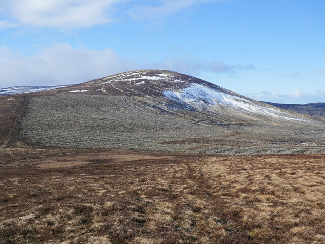
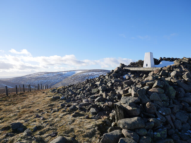
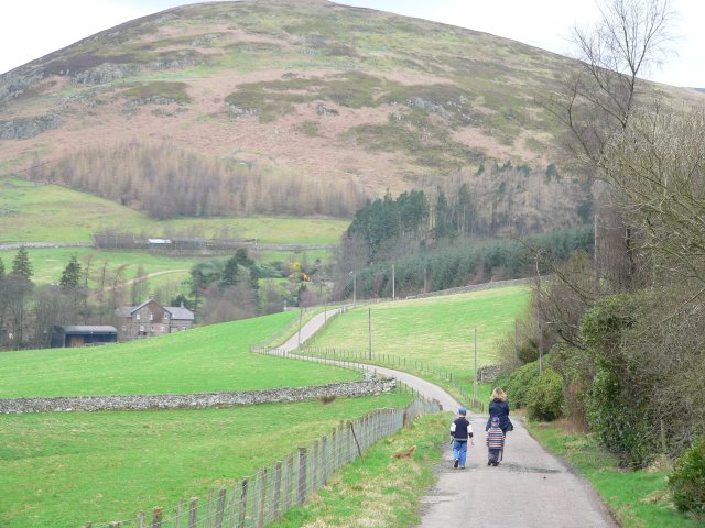
Hedgehope Hill is a prominent hill located in the county of Northumberland, England. Standing at an elevation of 714 meters (2,343 feet), it is considered one of the highest peaks in the region. Situated within the Northumberland National Park, it offers breathtaking panoramic views of the surrounding countryside.

The hill is characterized by its distinctive conical shape, covered in heather and grasses, which is a typical feature of the Cheviot Hills range. It is part of a popular walking route known as the "Ingram Valley and Hedgehope Hill Circular Walk," attracting both locals and tourists alike.

The ascent to the summit of Hedgehope Hill is moderately challenging, with a well-defined path leading to the top. The final climb can be steep in places but rewards hikers with stunning vistas across the Cheviots and beyond. On a clear day, it is possible to see as far as the North Sea coast and the Scottish borders.

Wildlife enthusiasts will be delighted to spot a variety of bird species, including merlins, kestrels, and the elusive red grouse, which are native to the area. The hill is also home to a diverse range of flora, such as cotton grass, bilberry, and heather, providing a colorful and vibrant landscape throughout the year.

Hedgehope Hill offers an ideal location for outdoor activities, including hillwalking, hiking, and photography. Its accessibility and natural beauty make it a must-visit destination for those seeking an immersive experience in the Northumberland countryside.

If you have any feedback on the listing, please let us know in the comments section below.

Hedgehope Hill Images

Images are sourced within 2km of 55.471905/-2.0903589 or Grid Reference NT9419. Thanks to Geograph Open Source API. All images are credited.

Hedgehope Hill and the Threestoneburn Wood clearfell from Dunmoor Hill A view across the managed grouse moorland of Dunmoor Hill towards Hedgehope Hill; the clearfelled site of the western extent of the former Threestoneburn Wood is conspicuous in this shot.

This photograph was taken during the Coronavirus (COVID-19) pandemic of 2020/21/22.
Hedgehope Hill and the Threestoneburn Wood clearfell from Dunmoor Hill
A view across the managed grouse moorland of Dunmoor Hill towards Hedgehope Hill; the clearfelled site of the western extent of the former Threestoneburn Wood is conspicuous in this shot. This photograph was taken during the Coronavirus (COVID-19) pandemic of 2020/21/22.
Self-seeded spruce trees from the former Threestoneburn Wood Some self-seeded spruce trees can be found on the northern slope of Dunmoor Hill in managed grouse moorland.  The clearfelled Threestoneburn Wood remains can be noted in the background whilst Hedgehope Hill looms over the scene in the background.

This photograph was taken during the Coronavirus (COVID-19) pandemic of 2020/21/22.
Self-seeded spruce trees from the former Threestoneburn Wood
Some self-seeded spruce trees can be found on the northern slope of Dunmoor Hill in managed grouse moorland. The clearfelled Threestoneburn Wood remains can be noted in the background whilst Hedgehope Hill looms over the scene in the background. This photograph was taken during the Coronavirus (COVID-19) pandemic of 2020/21/22.
Clearfell below Hedgehope Hill The south-west corner of the former Threestoneburn Wood.

This photograph was taken during the Coronavirus (COVID-19) pandemic of 2020/21/22.
Clearfell below Hedgehope Hill
The south-west corner of the former Threestoneburn Wood. This photograph was taken during the Coronavirus (COVID-19) pandemic of 2020/21/22.
Looking back to Dunmoor Hill On a boggy quadbike-rutted track bound for Hedgehope Hill.

This photograph was taken during the Coronavirus (COVID-19) pandemic of 2020/21/22.
Looking back to Dunmoor Hill
On a boggy quadbike-rutted track bound for Hedgehope Hill. This photograph was taken during the Coronavirus (COVID-19) pandemic of 2020/21/22.
Heading up Hedgehope Hill The route up Hedgehope Hill has been badly rutted by quadbikes and provides a gutter for meltwater as seen in this shot.  The former Threestoneburn Wood is out of shot to the right.

This photograph was taken during the Coronavirus (COVID-19) pandemic of 2020/21/22.
Heading up Hedgehope Hill
The route up Hedgehope Hill has been badly rutted by quadbikes and provides a gutter for meltwater as seen in this shot. The former Threestoneburn Wood is out of shot to the right. This photograph was taken during the Coronavirus (COVID-19) pandemic of 2020/21/22.
A meeting of fences on the south east side of Hedgehope Hill The clearfelled Threestoneburn Wood can be noted to the far left of shot, with the muirburn mosaic on Dunmoor Hill evident left of centre in the distance.

This photograph was taken during the Coronavirus (COVID-19) pandemic of 2020/21/22.
A meeting of fences on the south east side of Hedgehope Hill
The clearfelled Threestoneburn Wood can be noted to the far left of shot, with the muirburn mosaic on Dunmoor Hill evident left of centre in the distance. This photograph was taken during the Coronavirus (COVID-19) pandemic of 2020/21/22.
A late winter afternoon at the summit of Hedgehope Hill The summit area including wind shelter and triangulation pillar.  The Cheviot massif can be noted in the background.

This photograph was taken during the Coronavirus (COVID-19) pandemic of 2020/21/22.
A late winter afternoon at the summit of Hedgehope Hill
The summit area including wind shelter and triangulation pillar. The Cheviot massif can be noted in the background. This photograph was taken during the Coronavirus (COVID-19) pandemic of 2020/21/22.
Moorland below Hedgehope Hill The descent of Hedgehope Hill to Great Standrop was made by following quadbike tracks through heather moorland.  This view looks back towards Hedgehope across a frozen peaty pool.

This photograph was taken during the Coronavirus (COVID-19) pandemic of 2020/21/22.
Moorland below Hedgehope Hill
The descent of Hedgehope Hill to Great Standrop was made by following quadbike tracks through heather moorland. This view looks back towards Hedgehope across a frozen peaty pool. This photograph was taken during the Coronavirus (COVID-19) pandemic of 2020/21/22.
An old sheepfold by Threestone Burn With the removal of Threestoneburn Wood over the past decade, old features of former open moorland are once again evident such as this sheepfold.  Plantings of native tree species shrouded by tree protectors are evident beside the Threestone Burn.

This photograph was taken during the Coronavirus (COVID-19) pandemic of 2020/21/22.
An old sheepfold by Threestone Burn
With the removal of Threestoneburn Wood over the past decade, old features of former open moorland are once again evident such as this sheepfold. Plantings of native tree species shrouded by tree protectors are evident beside the Threestone Burn. This photograph was taken during the Coronavirus (COVID-19) pandemic of 2020/21/22.
From the end of the track The western end of a timber extraction track in the former Threestoneburn Wood offers a bleak view across tree debris to Hedgehope Hill.

This photograph was taken during the Coronavirus (COVID-19) pandemic of 2020/21/22.
From the end of the track
The western end of a timber extraction track in the former Threestoneburn Wood offers a bleak view across tree debris to Hedgehope Hill. This photograph was taken during the Coronavirus (COVID-19) pandemic of 2020/21/22.
Southern edge of Threestoneburn Wood The boundary fence leads downhill to the watershed of the Dunmoor Burn. The hill in the background is Dunmoor Hill. For a free selection of walking routes in the Cheviot Hills visit <span class="nowrap"><a title="www.cheviotwalks.co.uk" rel="nofollow ugc noopener" href="http://www.cheviotwalks.co.uk">Link</a><img style="margin-left:2px;" alt="External link" title="External link - shift click to open in new window" src="https://s1.geograph.org.uk/img/external.png" width="10" height="10"/></span>
Southern edge of Threestoneburn Wood
The boundary fence leads downhill to the watershed of the Dunmoor Burn. The hill in the background is Dunmoor Hill. For a free selection of walking routes in the Cheviot Hills visit LinkExternal link
Great Standrop Great Standrop, Standrop Rigg
Great Standrop
Great Standrop, Standrop Rigg
Block scree near summit of Hedgehope Hill View down the west ridge towards Cold Fell.
Block scree near summit of Hedgehope Hill
View down the west ridge towards Cold Fell.
Cairn at summit of Hedgehope Hill
Summit cairn Hedgehope Hill
Gate south-west of Hedgehope Hill summit View down the ridge towards Comb Fell. Scotsman's Knowe is in the centre at the head of the Harthope valley with Cairn Hill, the south-west ridge of Cheviot, the higher point to its right.
Gate south-west of Hedgehope Hill summit
View down the ridge towards Comb Fell. Scotsman's Knowe is in the centre at the head of the Harthope valley with Cairn Hill, the south-west ridge of Cheviot, the higher point to its right.
Gate south-west of Hedgehope Hill summit View towards Hedgehope Hill.
Gate south-west of Hedgehope Hill summit
View towards Hedgehope Hill.
Blue sky over Hedgehope Hill View from the peaty moorland west of the summit.
Blue sky over Hedgehope Hill
View from the peaty moorland west of the summit.
Show me another place!

Hedgehope Hill is located at Grid Ref: NT9419 (Lat: 55.471905, Lng: -2.0903589)

Unitary Authority: Northumberland

Police Authority: Northumbria

What 3 Words

///pollution.intrigues.mixed. Near Kirknewton, Northumberland

Nearby Locations

Hedgehope Hill

Related Wikis

Hedgehope Hill

Hedgehope Hill is a mountain in the Cheviot Hills of north Northumberland in northeast England, and categorised as a Hewitt. At a height of 714 metres...

Threestoneburn Stone Circle

Threestoneburn Stone Circle is an archaeological site, a stone circle near the village of Ilderton and about 5 miles (8 km) south of Wooler, in Northumberland...

The Cheviot

The Cheviot () is an extinct volcano and the highest summit in the Cheviot Hills and in the county of Northumberland. Located in the extreme north of England...

Cheviot Hills

The Cheviot Hills (), or sometimes The Cheviots, are a range of uplands straddling the Anglo-Scottish border between Northumberland and the Scottish Borders...

Linhope

Linhope is a small village in Northumberland, England. It is located in the Cheviots on the River Breamish, and within Northumberland National Park. Linhope...

Ilderton, Northumberland

Ilderton is a small village in Northumberland, England. It is located on the edge of the Northumberland National Park, between Lilburn, Northumberland...

Ilderton Hall

Ilderton Hall is a modest 18th-century country house at Ilderton, Northumberland.(grid reference NU01662177). It is a Grade II listed building.The house...

Kidland

Kidland is a former civil parish, now in the parish of Alwinton in Northumberland, England, about 2 miles (3 km) northwest of Alwinton village. In 1951...

Nearby Amenities

Located within 500m of 55.471905,-2.0903589
Hedgehope Hill
Ele: 714
Natural: peak
Wikidata: Q5697321
Wikipedia: en:Hedgehope Hill
Lat/Long: 55.4719221/-2.0903528
Man Made: cairn
Lat/Long: 55.4719533/-2.0903799
The data included in this document is from www.openstreetmap.org. The data is made available under ODbL.

Have you been to Hedgehope Hill?

Leave your review of Hedgehope Hill below (or comments, questions and feedback).