Turf Hill

Hill, Mountain in Northumberland

England

Turf Hill

Footbridge over Usway Burn This footbridge crosses from the eastern bank of the Usway Burn to the western bank giving access, via a Public Bridleway, to the farm at Shillmoor. It lies next to a concrete ford, and a matter of metres downstream the Usway Burn flows into the River Coquet. For a selection of detailed free to download walking routes in the area visit <span class="nowrap"><a title="www.cheviotwalks.co.uk" rel="nofollow ugc noopener" href="http://www.cheviotwalks.co.uk">Link</a><img style="margin-left:2px;" alt="External link" title="External link - shift click to open in new window" src="https://s1.geograph.org.uk/img/external.png" width="10" height="10"/></span>
Footbridge over Usway Burn Credit: Geoff Holland

Turf Hill is a prominent hill located in the county of Northumberland, England. Situated in the northern part of the county, it is part of the beautiful landscape of the North Pennines, an Area of Outstanding Natural Beauty. Standing at an elevation of approximately 500 meters (1,640 feet), Turf Hill is renowned for its stunning views and rugged terrain.

The hill is characterized by its distinctive shape, with a gently sloping northern side and a steeper southern face. Its summit offers panoramic vistas of the surrounding countryside, including rolling hills, verdant valleys, and occasional glimpses of distant towns and villages.

Turf Hill is predominantly covered in heather, creating a vibrant purple carpet during the summer months when the plant blooms. The hill is also home to a diverse range of wildlife, including various bird species, such as curlews and lapwings, which nest in the surrounding moorland.

Access to Turf Hill is relatively easy, with several footpaths and trails leading to its summit. These routes attract hikers, nature enthusiasts, and photographers, who are drawn to the area's natural beauty and tranquility.

Turf Hill is not only a popular destination for outdoor activities and exploration but also serves as a landmark for the local community. It holds historical significance, with remnants of ancient settlements and archaeological sites scattered across its slopes, providing a glimpse into the area's rich past.

Overall, Turf Hill is a captivating natural landmark in Northumberland, offering breathtaking views, diverse wildlife, and a sense of history. It is an ideal destination for those seeking a peaceful retreat or an adventure amidst the stunning North Pennines landscape.

If you have any feedback on the listing, please let us know in the comments section below.
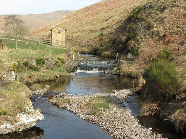
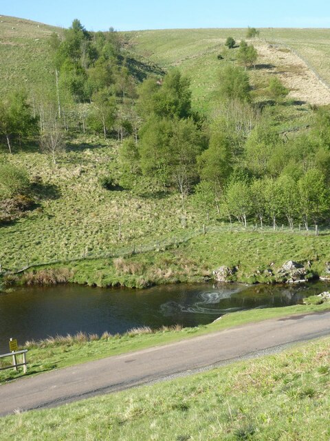
Turf Hill Images

Images are sourced within 2km of 55.36055/-2.2114222 or Grid Reference NT8607. Thanks to Geograph Open Source API. All images are credited.

Footbridge over Usway Burn This footbridge crosses from the eastern bank of the Usway Burn to the western bank giving access, via a Public Bridleway, to the farm at Shillmoor. It lies next to a concrete ford, and a matter of metres downstream the Usway Burn flows into the River Coquet. For a selection of detailed free to download walking routes in the area visit <span class="nowrap"><a title="www.cheviotwalks.co.uk" rel="nofollow ugc noopener" href="http://www.cheviotwalks.co.uk">Link</a><img style="margin-left:2px;" alt="External link" title="External link - shift click to open in new window" src="https://s1.geograph.org.uk/img/external.png" width="10" height="10"/></span>
Footbridge over Usway Burn
This footbridge crosses from the eastern bank of the Usway Burn to the western bank giving access, via a Public Bridleway, to the farm at Shillmoor. It lies next to a concrete ford, and a matter of metres downstream the Usway Burn flows into the River Coquet. For a selection of detailed free to download walking routes in the area visit LinkExternal link
Weir on the Usway Burn, Shillmoor Taken from the footbridge shown at <a title="https://www.geograph.org.uk/photo/7126257" href="https://www.geograph.org.uk/photo/7126257">Link</a> and looking upstream, this photo shows the weir at Shillmoor and an associated building (purpose unknown). For a selection of detailed free to download walking routes in the area visit <span class="nowrap"><a title="www.cheviotwalks.co.uk" rel="nofollow ugc noopener" href="http://www.cheviotwalks.co.uk">Link</a><img style="margin-left:2px;" alt="External link" title="External link - shift click to open in new window" src="https://s1.geograph.org.uk/img/external.png" width="10" height="10"/></span>
Weir on the Usway Burn, Shillmoor
Taken from the footbridge shown at Link and looking upstream, this photo shows the weir at Shillmoor and an associated building (purpose unknown). For a selection of detailed free to download walking routes in the area visit LinkExternal link
Forest on Inner Hill Above Shillmoor in Upper Coquetdale.
Forest on Inner Hill
Above Shillmoor in Upper Coquetdale.
Drystone Wall on climb to Inner Hill This is yet another fine example of the art of drystone walling enclosing land behind Shillmoor Farm. For a selection of free to download detailed walking routes in the area visit <span class="nowrap"><a title="www.cheviotwalks.co.uk" rel="nofollow ugc noopener" href="http://www.cheviotwalks.co.uk">Link</a><img style="margin-left:2px;" alt="External link" title="External link - shift click to open in new window" src="https://s1.geograph.org.uk/img/external.png" width="10" height="10"/></span>
Drystone Wall on climb to Inner Hill
This is yet another fine example of the art of drystone walling enclosing land behind Shillmoor Farm. For a selection of free to download detailed walking routes in the area visit LinkExternal link
Path up South West Spur of Shillhope Law This path, in essence a mere sheep trace, starts at the base of Shillhope Cleugh and ultimately reaches the summit of Shillhope Law. The buildings in the distance are Bygate Hall Cottages. For a selection of free to download walking routes in the area visit <span class="nowrap"><a title="www.cheviotwalks.co.uk" rel="nofollow ugc noopener" href="http://www.cheviotwalks.co.uk">Link</a><img style="margin-left:2px;" alt="External link" title="External link - shift click to open in new window" src="https://s1.geograph.org.uk/img/external.png" width="10" height="10"/></span>
Path up South West Spur of Shillhope Law
This path, in essence a mere sheep trace, starts at the base of Shillhope Cleugh and ultimately reaches the summit of Shillhope Law. The buildings in the distance are Bygate Hall Cottages. For a selection of free to download walking routes in the area visit LinkExternal link
The Cheviot Hills from the air The south end of the range around Linshiels and Shilmoor.
The Cheviot Hills from the air
The south end of the range around Linshiels and Shilmoor.
View towards Bygate Hall Cottages Looking south along the River Coquet with Bygate Hall Cottages up to the right.
View towards Bygate Hall Cottages
Looking south along the River Coquet with Bygate Hall Cottages up to the right.
View along the Coquet Looking downstream. On the left, and just on the grid square boundary is a circular sheepfold and beyond that in the next square is Kateshaw Crag.
View along the Coquet
Looking downstream. On the left, and just on the grid square boundary is a circular sheepfold and beyond that in the next square is Kateshaw Crag.
Upstream along the Coquet Looking upstream along the River Coquet towards Barrowburn. High on the left is a corner of the plantation at Partridge Side.
Upstream along the Coquet
Looking upstream along the River Coquet towards Barrowburn. High on the left is a corner of the plantation at Partridge Side.
The Coquet above Shillmoor Looking downstream along the Coquet towards Shillmoor.
The Coquet above Shillmoor
Looking downstream along the Coquet towards Shillmoor.
Swan on the river Looking upstream along the Coquet next to a tiny island. The mute swan has chosen this remote stretch of river as a feeding ground.
Swan on the river
Looking upstream along the Coquet next to a tiny island. The mute swan has chosen this remote stretch of river as a feeding ground.
Filling potholes in Upper Coquetdale The large hose squirts tar covered gravel to fill the pothole - and then a bit more. The potholes have become mini pot-hills for later traffic to consolidate.
The machine effectively blocks the road. Fortunately a convenient cattle grid allowed space to pass.
Filling potholes in Upper Coquetdale
The large hose squirts tar covered gravel to fill the pothole - and then a bit more. The potholes have become mini pot-hills for later traffic to consolidate. The machine effectively blocks the road. Fortunately a convenient cattle grid allowed space to pass.
Sheepfold at Bygate Hall Cottages Beside the River Coquet.
Sheepfold at Bygate Hall Cottages
Beside the River Coquet.
Gate, Inner Hill near Shillmoor This five bar gate lies on the track which climbs Inner Hill towards Shillhope Law. The hill in the background is another Inner Hill, this one lying within the boundaries of the Otterburn Training Area. For a selection of detailed free to download walking routes in the area visit <span class="nowrap"><a title="www.cheviotwalks.co.uk" rel="nofollow ugc noopener" href="http://www.cheviotwalks.co.uk">Link</a><img style="margin-left:2px;" alt="External link" title="External link - shift click to open in new window" src="https://s1.geograph.org.uk/img/external.png" width="10" height="10"/></span>
Gate, Inner Hill near Shillmoor
This five bar gate lies on the track which climbs Inner Hill towards Shillhope Law. The hill in the background is another Inner Hill, this one lying within the boundaries of the Otterburn Training Area. For a selection of detailed free to download walking routes in the area visit LinkExternal link
Inner Hill near Shillmoor The small hill immediately ahead is Inner Hill whilst the large hill in the background is Shillhope Law. This photograph was taken at roughly the same spot as the one shown at <a title="https://www.geograph.org.uk/photo/1718473" href="https://www.geograph.org.uk/photo/1718473">Link</a> but 10 years and the seasons separate the two. For a selection of detailed free to download walking routes in the area visit <span class="nowrap"><a title="www.cheviotwalks.co.uk" rel="nofollow ugc noopener" href="http://www.cheviotwalks.co.uk">Link</a><img style="margin-left:2px;" alt="External link" title="External link - shift click to open in new window" src="https://s1.geograph.org.uk/img/external.png" width="10" height="10"/></span>
Inner Hill near Shillmoor
The small hill immediately ahead is Inner Hill whilst the large hill in the background is Shillhope Law. This photograph was taken at roughly the same spot as the one shown at Link but 10 years and the seasons separate the two. For a selection of detailed free to download walking routes in the area visit LinkExternal link
Shillmoor Farm This is part of the former stable and granary (with lean-to pig sty next to it) at Shillmoor Farm. The date 1815 is carved over the first floor window, presumably indicating the date it was built. It is a Grade II Listed building. For a selection of detailed free to download walking routes in the area visit <span class="nowrap"><a title="www.cheviotwalks.co.uk" rel="nofollow ugc noopener" href="http://www.cheviotwalks.co.uk">Link</a><img style="margin-left:2px;" alt="External link" title="External link - shift click to open in new window" src="https://s1.geograph.org.uk/img/external.png" width="10" height="10"/></span>
Shillmoor Farm
This is part of the former stable and granary (with lean-to pig sty next to it) at Shillmoor Farm. The date 1815 is carved over the first floor window, presumably indicating the date it was built. It is a Grade II Listed building. For a selection of detailed free to download walking routes in the area visit LinkExternal link
Froth patterns on the River Coquet Near Kateshaw Crag.
Froth patterns on the River Coquet
Near Kateshaw Crag.
The unprepossessing summit of Inner Hill With Shillhope Law in the distance.
The unprepossessing summit of Inner Hill
With Shillhope Law in the distance.
Show me another place!

Turf Hill is located at Grid Ref: NT8607 (Lat: 55.36055, Lng: -2.2114222)

Unitary Authority: Northumberland

Police Authority: Northumbria

What 3 Words

///sleepers.candle.civic. Near Rochester, Northumberland

Nearby Locations

Turf Hill

Related Wikis

Usway Burn

The Usway Burn is an upland river on the southern flanks of the Cheviot Hills, in the Northumberland National Park, England. It is a tributary of the River...

Shillhope Law

Shillhope Law is a hill in the southern Cheviots, a range of hills in Northumberland, England. Shillhope Law is a relatively unremarkable member of this...

Barrow Burn

Barrowburn is a hamlet in Upper Coquetdale in the county of Northumberland, England. It comprises a working farm with associated buildings and two holiday...

Barrow Burn Meadows

Barrow Burn Meadows is a Site of Special Scientific Interest (SSSI) in north Northumberland, England. The site is a species-rich hay meadow of a sort now...

Northumberland National Park

Northumberland National Park is the northernmost national park in England. It covers an area of more than 1,050 square kilometres (410 sq mi) between the...

Barrow Meadow

Barrow Meadow is a Site of Special Scientific Interest (SSSI) in north Northumberland, England. The site is a species-rich hay meadow of a sort now rare...

Featherwood Roman Camps

Featherwood Roman Camps are neighbouring archaeological sites in Northumberland, England, 1 mile (1.6 km) north of Featherwood and about 3 miles (5 km...

Alwinton

Alwinton (previously named "Allenton" and sometimes still referred to as this) is a village and former parish in Northumberland, England. Alwinton is named...

Nearby Amenities

Located within 500m of 55.36055,-2.2114222
Through Hill
Place: locality
Lat/Long: 55.3621793/-2.2074382
Turf Hill
Place: locality
Lat/Long: 55.359379/-2.2147253
The data included in this document is from www.openstreetmap.org. The data is made available under ODbL.

Have you been to Turf Hill?

Leave your review of Turf Hill below (or comments, questions and feedback).