Black Hag

Hill, Mountain in Northumberland

England

Black Hag

Gate, Steer Rig This gate connects Scotland with England and lies adjacent to the route of the Pennine Way. The hills in the background (England) are, from left to right, Great Hetha, Yeavering Bell, Easter Tor, Wester Tor and Hare Law. For a selection of detailed free to download walking routes in the area visit <span class="nowrap"><a title="www.cheviotwalks.co.uk" rel="nofollow ugc noopener" href="http://www.cheviotwalks.co.uk">Link</a><img style="margin-left:2px;" alt="External link" title="External link - shift click to open in new window" src="https://s1.geograph.org.uk/img/external.png" width="10" height="10"/></span>
Gate, Steer Rig Credit: Geoff Holland

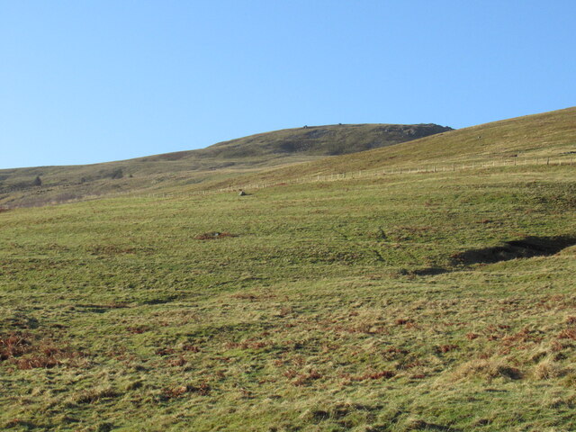
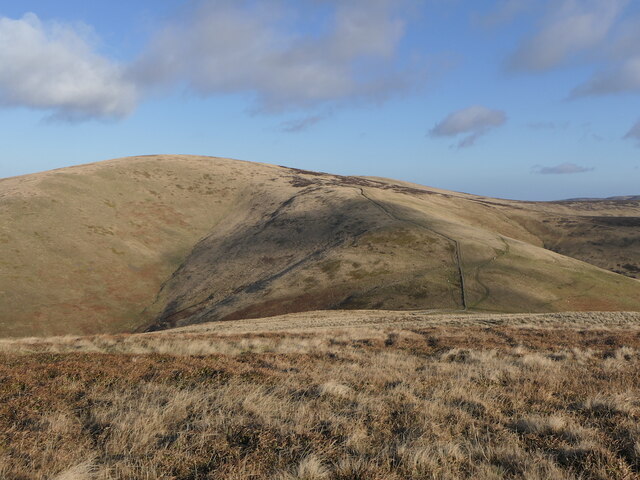
Black Hag is a prominent hill located in the county of Northumberland, England. It is part of the wider North Pennines Area of Outstanding Natural Beauty and stands at an elevation of approximately 546 meters (1,791 feet) above sea level. The hill is situated near the village of Allendale, offering breathtaking views of the surrounding landscape.

Black Hag is renowned for its rugged and wild beauty, attracting many hikers, nature enthusiasts, and photographers. The hill is primarily composed of a mixture of grassy slopes and rocky outcrops, giving it a distinct and striking appearance. Its exposed summit offers panoramic vistas of the North Pennines, with rolling hills and valleys stretching as far as the eye can see.

The hill is popular among walkers and hikers due to its accessibility and the variety of routes available. There are well-maintained footpaths and trails leading to the summit, allowing visitors to explore the hill at their own pace. The ascent can be challenging in places, but the rewarding views and the sense of accomplishment make it a worthwhile endeavor.

Black Hag is also home to a diverse range of flora and fauna, including heather, bilberry, and various species of birds and butterflies. The hill's natural beauty and tranquil atmosphere make it a peaceful retreat for those seeking solitude and a connection with nature.

Overall, Black Hag is a stunning natural feature in Northumberland, offering both recreational opportunities and a chance to appreciate the region's scenic wonders.

If you have any feedback on the listing, please let us know in the comments section below.

Black Hag Images

Images are sourced within 2km of 55.507033/-2.2212637 or Grid Reference NT8623. Thanks to Geograph Open Source API. All images are credited.

Gate, Steer Rig This gate connects Scotland with England and lies adjacent to the route of the Pennine Way. The hills in the background (England) are, from left to right, Great Hetha, Yeavering Bell, Easter Tor, Wester Tor and Hare Law. For a selection of detailed free to download walking routes in the area visit <span class="nowrap"><a title="www.cheviotwalks.co.uk" rel="nofollow ugc noopener" href="http://www.cheviotwalks.co.uk">Link</a><img style="margin-left:2px;" alt="External link" title="External link - shift click to open in new window" src="https://s1.geograph.org.uk/img/external.png" width="10" height="10"/></span>
Gate, Steer Rig
This gate connects Scotland with England and lies adjacent to the route of the Pennine Way. The hills in the background (England) are, from left to right, Great Hetha, Yeavering Bell, Easter Tor, Wester Tor and Hare Law. For a selection of detailed free to download walking routes in the area visit LinkExternal link
English/Scottish Border, Steer Rig The fence marks the border between England (left) and Scotland (right) whilst the track is the route of the Pennine Way. The hill right of centre is The Curr (Scotland) whilst the one left of centre is Black Hag (England). For a selection of detailed free to download walking routes in the area visit <span class="nowrap"><a title="www.cheviotwalks.co.uk" rel="nofollow ugc noopener" href="http://www.cheviotwalks.co.uk">Link</a><img style="margin-left:2px;" alt="External link" title="External link - shift click to open in new window" src="https://s1.geograph.org.uk/img/external.png" width="10" height="10"/></span>
English/Scottish Border, Steer Rig
The fence marks the border between England (left) and Scotland (right) whilst the track is the route of the Pennine Way. The hill right of centre is The Curr (Scotland) whilst the one left of centre is Black Hag (England). For a selection of detailed free to download walking routes in the area visit LinkExternal link
Wall and Fence, Steerrig Knowe The wall and fence tumble down towards the head of the Halter Burn before climbing the slopes of Latchly Hill seen slightly right of centre. For a selection of detailed free to download walking routes in the area visit <span class="nowrap"><a title="www.cheviotwalks.co.uk" rel="nofollow ugc noopener" href="http://www.cheviotwalks.co.uk">Link</a><img style="margin-left:2px;" alt="External link" title="External link - shift click to open in new window" src="https://s1.geograph.org.uk/img/external.png" width="10" height="10"/></span>
Wall and Fence, Steerrig Knowe
The wall and fence tumble down towards the head of the Halter Burn before climbing the slopes of Latchly Hill seen slightly right of centre. For a selection of detailed free to download walking routes in the area visit LinkExternal link
Summit of Black Hag The fence post marks the 549 metre top of Black Hag with The Schil dominant in the background. The same fence post looking in a different direction is shown at <a title="https://www.geograph.org.uk/photo/6553035" href="https://www.geograph.org.uk/photo/6553035">Link</a>. For a selection of detailed free to download walking routes in the area visit <span class="nowrap"><a title="www.cheviotwalks.co.uk" rel="nofollow ugc noopener" href="http://www.cheviotwalks.co.uk">Link</a><img style="margin-left:2px;" alt="External link" title="External link - shift click to open in new window" src="https://s1.geograph.org.uk/img/external.png" width="10" height="10"/></span>
Summit of Black Hag
The fence post marks the 549 metre top of Black Hag with The Schil dominant in the background. The same fence post looking in a different direction is shown at Link. For a selection of detailed free to download walking routes in the area visit LinkExternal link
Replanted woodland, Fleehope
East side of The Schil Above Mounthooly.
East side of The Schil
Above Mounthooly.
The Curr View from Blackdean Curr.
The Curr
View from Blackdean Curr.
The Schill Hill on the Border ridge, viewed from Blackdean Curr.
The Schill
Hill on the Border ridge, viewed from Blackdean Curr.
Dyke and paths, The Curr Radiating from the col on the Windy Path above Auchope.
Dyke and paths, The Curr
Radiating from the col on the Windy Path above Auchope.
Windy Path Col Pass between Blackdean Curr and The Curr served by a track up from Auchope.
Windy Path Col
Pass between Blackdean Curr and The Curr served by a track up from Auchope.
Col, Windy Path Between Blackhope Curr and The Curr.
Col, Windy Path
Between Blackhope Curr and The Curr.
Dyke on the Curr Climbing away from the Windy Path
Dyke on the Curr
Climbing away from the Windy Path
Quadbike track on The Curr
Fence, The Curr
Fence, The Curr
Summit, The Curr
Summit, The Curr
Eastward view from The Curr
Fence junction, The Curr
Show me another place!

Black Hag is located at Grid Ref: NT8623 (Lat: 55.507033, Lng: -2.2212637)

Unitary Authority: Northumberland

Police Authority: Northumbria

What 3 Words

///pranced.orbited.throwaway. Near Kirknewton, Northumberland

Nearby Locations

Black Hag

Related Wikis

College Valley

The College Valley is one of five cuttings into the Cheviot Hills. The valley is owned by College Valley Estates which in turn is funded by a trust created...

Mowhaugh

Mowhaugh is a hamlet and farm steading near the Calroust Burn and the Bowmont Water, near Morebattle, in the Scottish Borders area of Scotland, and in...

Cheviot Hills

The Cheviot Hills (), or sometimes The Cheviots, are a range of uplands straddling the Anglo-Scottish border between Northumberland and the Scottish Borders...

Yetholm

Yetholm is the parish that contained the villages of Kirk Yetholm and Town Yetholm in the east of the former county of Roxburghshire, nowadays in the Scottish...

Nearby Amenities

Located within 500m of 55.507033,-2.2212637
Black Hag
Ele: 549
Natural: peak
Place: locality
Lat/Long: 55.5071446/-2.2212899
Pennine Way Low/High Route Split
Lat/Long: 55.5051544/-2.2242227
Barrier: stile
Source: survey
Lat/Long: 55.5033021/-2.2174432
Barrier: stile
Source: survey
Lat/Long: 55.5070633/-2.2265595
The data included in this document is from www.openstreetmap.org. The data is made available under ODbL.

Have you been to Black Hag?

Leave your review of Black Hag below (or comments, questions and feedback).