Brown Hill
Hill, Mountain in Durham
England
Brown Hill

Brown Hill is a prominent hill located in Durham, County Durham, England. As part of the Pennines, it forms an important feature of the landscape in this region. The hill is situated approximately 4 miles west of Durham city center and stands at an elevation of 282 meters (925 feet) above sea level.
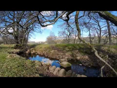
Covered in lush green vegetation, Brown Hill offers breathtaking panoramic views of the surrounding countryside. It is a popular destination for hikers, nature enthusiasts, and photographers due to its commanding position and its unspoiled natural beauty. Visitors can enjoy the serenity of the hilltop, taking in the picturesque vistas of rolling hills, valleys, and woodlands that stretch as far as the eye can see.
The summit of Brown Hill is marked by a trig point, indicating its importance as a geodetic reference point. This, combined with its elevation, makes it a significant landmark for cartographers and surveyors in the area.
Brown Hill is also home to a diverse range of wildlife. The hillside supports a variety of plant species, including heather, bracken, and grasses, providing a habitat for numerous small mammals, birds, and insects. It is not uncommon to spot rabbits, hares, or even the elusive red fox while exploring the area.
Overall, Brown Hill in Durham is a captivating natural feature, offering both recreational and scientific value to its visitors. Whether one seeks a peaceful hike, stunning views, or an opportunity to study the local flora and fauna, Brown Hill is an ideal destination.
If you have any feedback on the listing, please let us know in the comments section below.
Brown Hill Images
Images are sourced within 2km of 54.674667/-2.2250522 or Grid Reference NY8531. Thanks to Geograph Open Source API. All images are credited.


Brown Hill is located at Grid Ref: NY8531 (Lat: 54.674667, Lng: -2.2250522)
Unitary Authority: County Durham
Police Authority: Durham
What 3 Words
///jars.seating.baseless. Near Holwick, Co. Durham
Nearby Locations
Related Wikis

Langdon Beck
Langdon Beck is a village in County Durham, England. It is situated in upper Teesdale, between Forest-in-Teesdale and Harwood, halfway between Penrith...

Forest and Frith
Forest and Frith is a civil parish in the County Durham unitary authority, in the ceremonial county of Durham, England. In the 2011 census it had a population...
Forest-in-Teesdale
Forest-in-Teesdale is a village in County Durham, England. It is situated in upper Teesdale, on the north side of the Tees between Newbiggin and Langdon...

Upper Teesdale
Upper Teesdale is a Site of Special Scientific Interest (SSSI) in the west County Durham, England. It encompasses an extensive upland area that includes...

Harwood, County Durham
Harwood is a small valley and village near the head of Teesdale. Harwood Beck is a tributary of the River Tees in County Durham which forms a short valley...
Ettersgill
Ettersgill is a village in County Durham, England. It is situated at the top of Teesdale, on the north side of the Tees between Newbiggin and Forest-in...

High Force
High Force is a waterfall on the River Tees, near Middleton-in-Teesdale, Teesdale, England. The waterfall is within the North Pennines Area of Outstanding...
Harthope Moss
Harthope Moss, also known as Chapel Fell (elevation 627 m; 2,057 ft) is a mountain pass in the English Pennines. The pass divides Weardale to the north...
Related Videos
Hiking for Health, Cronkley Fell, Upper Teesdale September 2021
An easy/intermediate hike over Cronkley Fell, Forest in Teasdale. I work for the NHS and started hiking again a few months ago to ...

Across & Around Cronkley Fell ( Upper Teesdale)
No May Highland adventure, so off to familiar grounds of Upper Teesdale. All weather, sun, drizzle, thunder and wind. All training ...
19 Pennine Way, Day 9. From River Tees (223 km) to Forest-in-Teesdale (231 km)
Pennine Way, 7th March 2023, Tuesday. From River Tees (223 km) to Forest-in-Teesdale (231 km).
Forest-In-Teesdale
Forest-in-Teesdale is located in the Northern Pennines - bordering Cumbria to the west and the Yorkshire Dales to the south.
Nearby Amenities
Located within 500m of 54.674667,-2.2250522Have you been to Brown Hill?
Leave your review of Brown Hill below (or comments, questions and feedback).