Blaydike Moss

Hill, Mountain in Yorkshire Craven

England

Blaydike Moss

Foxup The farm and houses at Foxup with the valley of Foxup Beck cutting through Foxup Moor in the background.  In the far distance, over the horizon, is the distinctive outline of Ingleborough.
Foxup Credit: Peter McDermott

The requested URL returned error: 429 Too Many Requests

If you have any feedback on the listing, please let us know in the comments section below.

Blaydike Moss Images

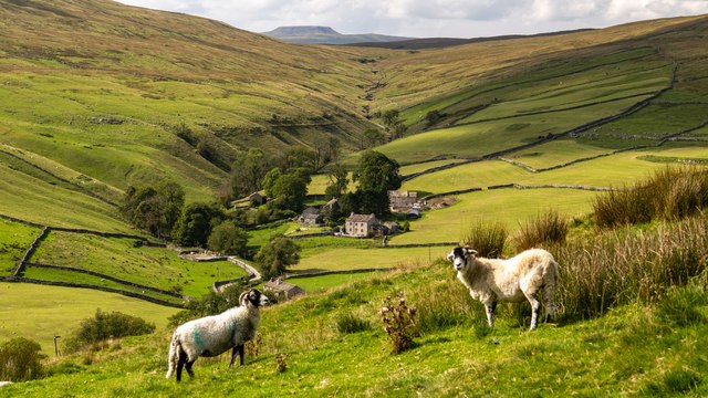
Images are sourced within 2km of 54.191232/-2.2275952 or Grid Reference SD8577. Thanks to Geograph Open Source API. All images are credited.

Foxup The farm and houses at Foxup with the valley of Foxup Beck cutting through Foxup Moor in the background.  In the far distance, over the horizon, is the distinctive outline of Ingleborough.
Foxup
The farm and houses at Foxup with the valley of Foxup Beck cutting through Foxup Moor in the background. In the far distance, over the horizon, is the distinctive outline of Ingleborough.
Trig point of Cosh Outside The trig point stands at 599m on a hill apparently unnamed, but with High Green Field Knott printed close by on OS maps; it's doubtful if that name is applied to the hill. The trig point is a few metres lower than the hill's actual high point which is given as 602m and lies over a kilometre away. Plover Hill and Pen-y-ghent are the lightly snowed hills in the distance.
Trig point of Cosh Outside
The trig point stands at 599m on a hill apparently unnamed, but with High Green Field Knott printed close by on OS maps; it's doubtful if that name is applied to the hill. The trig point is a few metres lower than the hill's actual high point which is given as 602m and lies over a kilometre away. Plover Hill and Pen-y-ghent are the lightly snowed hills in the distance.
The northern escarpment of Plover Hill The edge of the escarpment has a scatter of gritstone outcrops and makes a better spot for a break than the rather dull summit area of the hill. There is a fine view over the gulf of Foxup Moor to Cosh Outside with its small conifer copses and many more summits further north in the Yorkshire Dales and beyond.
The northern escarpment of Plover Hill
The edge of the escarpment has a scatter of gritstone outcrops and makes a better spot for a break than the rather dull summit area of the hill. There is a fine view over the gulf of Foxup Moor to Cosh Outside with its small conifer copses and many more summits further north in the Yorkshire Dales and beyond.
Limestone outcrops by the Foxup Road The creators of the packhorse route between Ribblesdale and Littondale deliberately aligned their track to run along this layer of limestone thus ensuring firm and well-drained surfaces in the main. The sheep also like the better grazing that limestone affords.
Limestone outcrops by the Foxup Road
The creators of the packhorse route between Ribblesdale and Littondale deliberately aligned their track to run along this layer of limestone thus ensuring firm and well-drained surfaces in the main. The sheep also like the better grazing that limestone affords.
The pitched path north of Plover Hill Since 2008 <a title="https://www.geograph.org.uk/photo/996209" href="https://www.geograph.org.uk/photo/996209">Link</a> the public footpath has been restored <a title="https://www.geograph.org.uk/photo/1578315" href="https://www.geograph.org.uk/photo/1578315">Link</a> by pitching large blocks on a diagonal line down the escarpment. This has nipped a potentially large erosion scar in the bud, an example of pre-emptive footpath maintenance by the National Park authority. The blocks are starting to weather in and the bare soil is grassing back over quite well.
The pitched path north of Plover Hill
Since 2008 Link the public footpath has been restored Link by pitching large blocks on a diagonal line down the escarpment. This has nipped a potentially large erosion scar in the bud, an example of pre-emptive footpath maintenance by the National Park authority. The blocks are starting to weather in and the bare soil is grassing back over quite well.
Walled meadowland at Foxup These meadows are the last [or first] of the improved pastures at the head of Littondale, stretching along the valley of Cosh Beck. The series of field barns are marked on the map as Harrop Barns.
Walled meadowland at Foxup
These meadows are the last [or first] of the improved pastures at the head of Littondale, stretching along the valley of Cosh Beck. The series of field barns are marked on the map as Harrop Barns.
Path junction on Foxup Moor The path for Plover Hill leaves the Foxup bridleway here
Path junction on Foxup Moor
The path for Plover Hill leaves the Foxup bridleway here
Looking down the Plover Hill path towards Foxup Moor
Cosh Beck The beck beside a track that runs parallel to it, giving access to the remote farm of Cosh
Cosh Beck
The beck beside a track that runs parallel to it, giving access to the remote farm of Cosh
The Road to Cosh Track that runs for almost two miles from Foxup to the remote dwelling of Cosh - recently restored.
The Road to Cosh
Track that runs for almost two miles from Foxup to the remote dwelling of Cosh - recently restored.
Valley of Cosh Beck Looking down the valley of Cosh Beck as it makes its way to unify with Foxup Beck to form the River Skirfare - or is it Coshdale?
Valley of Cosh Beck
Looking down the valley of Cosh Beck as it makes its way to unify with Foxup Beck to form the River Skirfare - or is it Coshdale?
Abandoned Sheepfold by Cosh Beck The walls have tumbled down and broken, the floor now given over to rushes and other moorland vegetation.
Abandoned Sheepfold by Cosh Beck
The walls have tumbled down and broken, the floor now given over to rushes and other moorland vegetation.
Boundary Wall on Ber Gill Frozen conditions on the ridge summit that separates the valley of Cosh Beck from that of Foxup Beck.
Boundary Wall on Ber Gill
Frozen conditions on the ridge summit that separates the valley of Cosh Beck from that of Foxup Beck.
Track on Scutching Close Track running east over moorland towards the small community of Foxup
Track on Scutching Close
Track running east over moorland towards the small community of Foxup
Gate high above Foxup Beck A metal gate straddles a track on the northern side of the valley created by Foxup Beck
Gate high above Foxup Beck
A metal gate straddles a track on the northern side of the valley created by Foxup Beck
Descending to Foxup (1) Walled green lane descending to the small community of Foxup
Descending to Foxup (1)
Walled green lane descending to the small community of Foxup
Descending to Foxup (2) Green lane descending to Foxup, passing a ruined laithe or stone barn
Descending to Foxup (2)
Green lane descending to Foxup, passing a ruined laithe or stone barn
Track above Foxup Beck Track that leads up from Foxup and runs west onto high moorland
Track above Foxup Beck
Track that leads up from Foxup and runs west onto high moorland
Show me another place!

Blaydike Moss is located at Grid Ref: SD8577 (Lat: 54.191232, Lng: -2.2275952)

Division: West Riding

Administrative County: North Yorkshire

District: Craven

Police Authority: North Yorkshire

What 3 Words

///looms.garden.forms. Near Settle, North Yorkshire

Nearby Locations

Blaydike Moss

Related Wikis

Foxup

Foxup is a hamlet in the Yorkshire Dales in the Craven district of North Yorkshire, England. The hamlet is near Halton Gill and Litton and is 13 miles...

Plover Hill

Plover Hill is an area of moorland lying to the north of Pen-y-ghent in the Yorkshire Dales and connected to it by an unbroken area of high ground. Whilst...

Ewecross

The historical area of Ewecross or Ewcross is a district in the West Riding of Yorkshire, England. It included the parishes of Bentham, Clapham, Horton...

Halton Gill

Halton Gill is a hamlet and civil parish in Littondale in the Yorkshire Dales in North Yorkshire, England. It is situated 2 miles (3.2 km) up Littondale...

Nearby Amenities

Located within 500m of 54.191232,-2.2275952
Cosh Knott
Natural: peak
Lat/Long: 54.1910303/-2.2278512
Natural: sinkhole
Source: DigitalGlobe-Standard
Lat/Long: 54.1894119/-2.2333055
Natural: sinkhole
Source: EsriWorldImageryClarity
Lat/Long: 54.1942628/-2.2291081
Natural: sinkhole
Source: EsriWorldImageryClarity
Lat/Long: 54.193943/-2.2263722
Natural: sinkhole
Source: EsriWorldImageryClarity
Lat/Long: 54.1931769/-2.2276275
Natural: sinkhole
Source: EsriWorldImageryClarity
Lat/Long: 54.1950662/-2.2310071
Natural: sinkhole
Source: EsriWorldImageryClarity
Lat/Long: 54.1944325/-2.2250955
Natural: sinkhole
Source: EsriWorldImageryClarity
Lat/Long: 54.1940434/-2.2257607
Natural: sinkhole
Source: EsriWorldImageryClarity
Lat/Long: 54.1940556/-2.2266941
Natural: sinkhole
Source: EsriWorldImageryClarity
Lat/Long: 54.1936414/-2.2228854
Natural: sinkhole
Source: EsriWorldImageryClarity
Lat/Long: 54.1929951/-2.2302453
Natural: sinkhole
Source: EsriWorldImageryClarity
Lat/Long: 54.1947712/-2.2241621
Natural: sinkhole
Source: EsriWorldImageryClarity
Lat/Long: 54.1940117/-2.2221129
Natural: sinkhole
Source: EsriWorldImageryClarity
Lat/Long: 54.1942941/-2.2277348
Natural: sinkhole
Source: EsriWorldImageryClarity
Lat/Long: 54.1944828/-2.2258465
Natural: sinkhole
Source: EsriWorldImageryClarity
Lat/Long: 54.1942066/-2.2264044
Natural: sinkhole
Source: EsriWorldImageryClarity
Lat/Long: 54.1939301/-2.2260504
Natural: sinkhole
Source: EsriWorldImageryClarity
Lat/Long: 54.1944887/-2.2276812
Natural: sinkhole
Source: EsriWorldImageryClarity
Lat/Long: 54.1943255/-2.2289686
Natural: sinkhole
Source: EsriWorldImageryClarity
Lat/Long: 54.1948029/-2.2238295
Natural: sinkhole
Source: EsriWorldImageryClarity
Lat/Long: 54.1944074/-2.2271125
Natural: sinkhole
Source: EsriWorldImageryClarity
Lat/Long: 54.1943635/-2.2279923
Natural: sinkhole
Source: EsriWorldImageryClarity
Lat/Long: 54.1942628/-2.2286897
Natural: sinkhole
Source: EsriWorldImageryClarity
Lat/Long: 54.1932082/-2.2279601
Natural: sinkhole
Source: EsriWorldImageryClarity
Lat/Long: 54.194313/-2.2280674
Natural: sinkhole
Source: EsriWorldImageryClarity
Lat/Long: 54.1944887/-2.2264152
Natural: sinkhole
Source: EsriWorldImageryClarity
Lat/Long: 54.1938297/-2.2250955
Natural: sinkhole
Source: EsriWorldImageryClarity
Lat/Long: 54.1931831/-2.228121
Natural: sinkhole
Source: EsriWorldImageryClarity
Lat/Long: 54.1939932/-2.2232716
Natural: sinkhole
Source: EsriWorldImageryClarity
Lat/Long: 54.1941812/-2.2271447
Natural: sinkhole
Source: EsriWorldImageryClarity
Lat/Long: 54.1939932/-2.2272735
Natural: sinkhole
Source: EsriWorldImageryClarity
Lat/Long: 54.1942314/-2.2254174
Natural: sinkhole
Source: EsriWorldImageryClarity
Lat/Long: 54.1944137/-2.2278421
Natural: sinkhole
Source: EsriWorldImageryClarity
Lat/Long: 54.1928505/-2.2298591
Natural: sinkhole
Source: EsriWorldImageryClarity
Lat/Long: 54.1926876/-2.2210936
Natural: sinkhole
Source: EsriWorldImageryClarity
Lat/Long: 54.193905/-2.2261255
Natural: sinkhole
Source: EsriWorldImageryClarity
Lat/Long: 54.1937484/-2.2222094
Natural: sinkhole
Source: EsriWorldImageryClarity
Lat/Long: 54.1930011/-2.2261147
Natural: sinkhole
Source: EsriWorldImageryClarity
Lat/Long: 54.1943698/-2.2288291
Natural: sinkhole
Source: EsriWorldImageryClarity
Lat/Long: 54.193899/-2.2247844
Natural: sinkhole
Source: EsriWorldImageryClarity
Lat/Long: 54.1941124/-2.2270803
Natural: sinkhole
Source: EsriWorldImageryClarity
Lat/Long: 54.1942628/-2.2266083
Natural: sinkhole
Source: EsriWorldImageryClarity
Lat/Long: 54.1926245/-2.2207074
Natural: sinkhole
Source: EsriWorldImageryClarity
Lat/Long: 54.1939678/-2.225868
Natural: sinkhole
Source: EsriWorldImageryClarity
Lat/Long: 54.1933526/-2.2222309
Natural: sinkhole
Source: EsriWorldImageryClarity
Lat/Long: 54.1939552/-2.2222631
Natural: sinkhole
Source: EsriWorldImageryClarity
Lat/Long: 54.1935849/-2.2238402
Natural: sinkhole
Source: EsriWorldImageryClarity
Lat/Long: 54.192863/-2.2206109
Natural: sinkhole
Source: EsriWorldImageryClarity
Lat/Long: 54.1945267/-2.2265439
Natural: sinkhole
Source: EsriWorldImageryClarity
Lat/Long: 54.1940807/-2.2262971
Natural: sinkhole
Source: EsriWorldImageryClarity
Lat/Long: 54.1930702/-2.2224562
Natural: sinkhole
Source: EsriWorldImageryClarity
Lat/Long: 54.1943381/-2.2283463
Natural: sinkhole
Source: EsriWorldImageryClarity
Lat/Long: 54.1941812/-2.2256212
Natural: sinkhole
Source: EsriWorldImageryClarity
Lat/Long: 54.1943067/-2.2288291
Natural: sinkhole
Source: EsriWorldImageryClarity
Lat/Long: 54.1932334/-2.2275202
Natural: sinkhole
Source: EsriWorldImageryClarity
Lat/Long: 54.1929383/-2.227134
Natural: sinkhole
Source: EsriWorldImageryClarity
Lat/Long: 54.1941752/-2.2262006
Natural: sinkhole
Source: EsriWorldImageryClarity
Lat/Long: 54.1939301/-2.2237759
Natural: sinkhole
Source: EsriWorldImageryClarity
Lat/Long: 54.1942439/-2.228797
Natural: sinkhole
Source: EsriWorldImageryClarity
Lat/Long: 54.1940494/-2.2264903
Natural: sinkhole
Source: EsriWorldImageryClarity
Lat/Long: 54.1939241/-2.2326808
Natural: sinkhole
Source: EsriWorldImageryClarity
Lat/Long: 54.1936665/-2.2328417
The data included in this document is from www.openstreetmap.org. The data is made available under ODbL.

Have you been to Blaydike Moss?

Leave your review of Blaydike Moss below (or comments, questions and feedback).