Corbieknowe

Hill, Mountain in Kincardineshire

Scotland

Corbieknowe

Sill exposed on Darn Bay cliff The sill runs from half way up the left of the frame to the top of the cliff on the right in a very flattened S curve. Samples taken on 22 Dec 21 were consistent with lava. If this is an offshoot of the dyke shown on the BGS overlay about 100m to the left (W), then it is a 'North Britain Siluro-devonian Calc-alkaline Dyke Suite - Microgranite'. The rest of the cliffs are Gourdon conglomerate with interbedded sandstone layers.
Sill exposed on Darn Bay cliff Credit: Nigel Feilden

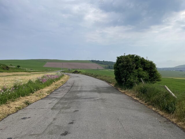
Corbieknowe is a small hill located in the county of Kincardineshire, Scotland. Rising to a height of approximately 350 meters, it offers panoramic views of the surrounding countryside and is a popular destination for hikers and nature enthusiasts.

Situated in a rural area, Corbieknowe is covered in lush green vegetation, characterized by heather, grasses, and scattered shrubs. The hill is part of a larger range known as the Grampian Mountains, which spans across several counties in Scotland.

Corbieknowe is home to a diverse range of flora and fauna. The hillside is dotted with various wildflowers, including primroses, bluebells, and harebells, creating a vibrant and colorful landscape during the spring and summer months. Bird species such as red grouse, skylarks, and meadow pipits can also be spotted in the area.

The hill is easily accessible by foot, with several well-maintained trails leading to the summit. These trails provide visitors with an opportunity to explore the surrounding countryside while enjoying the breathtaking views. The hill's modest height makes it suitable for hikers of all skill levels, offering a relatively easy climb.

Corbieknowe is an ideal location for those seeking a peaceful escape in nature. Its tranquil atmosphere and picturesque surroundings make it a popular spot for picnics, photography, and simply enjoying the outdoors. Whether it's the stunning vistas, the diverse wildlife, or the sense of tranquility, Corbieknowe has something to offer for everyone.

If you have any feedback on the listing, please let us know in the comments section below.

Corbieknowe Images

Images are sourced within 2km of 56.867898/-2.2575728 or Grid Reference NO8475. Thanks to Geograph Open Source API. All images are credited.

Sill exposed on Darn Bay cliff The sill runs from half way up the left of the frame to the top of the cliff on the right in a very flattened S curve. Samples taken on 22 Dec 21 were consistent with lava. If this is an offshoot of the dyke shown on the BGS overlay about 100m to the left (W), then it is a 'North Britain Siluro-devonian Calc-alkaline Dyke Suite - Microgranite'. The rest of the cliffs are Gourdon conglomerate with interbedded sandstone layers.
Sill exposed on Darn Bay cliff
The sill runs from half way up the left of the frame to the top of the cliff on the right in a very flattened S curve. Samples taken on 22 Dec 21 were consistent with lava. If this is an offshoot of the dyke shown on the BGS overlay about 100m to the left (W), then it is a 'North Britain Siluro-devonian Calc-alkaline Dyke Suite - Microgranite'. The rest of the cliffs are Gourdon conglomerate with interbedded sandstone layers.
Coarse conglomerate in the cliffs above Darn Bay Some of the rounded stones are getting on for a metre across - compare the fence posts above. The BGS has 'Rob's Cove Conglomerate Member - Conglomerate'
Coarse conglomerate in the cliffs above Darn Bay
Some of the rounded stones are getting on for a metre across - compare the fence posts above. The BGS has 'Rob's Cove Conglomerate Member - Conglomerate'
A lay-by on the A92
A lay-by on the A92
Southern approach to Catterline Photographer is above the pavement surface of the minor road
Southern approach to Catterline
Photographer is above the pavement surface of the minor road
Oilseed rape A field of oilseed rape beside a turn off for Catterline. The haar was presenting with me with a bit of a challenge, but the good news was that I was free of the commuters on the A92.
Oilseed rape
A field of oilseed rape beside a turn off for Catterline. The haar was presenting with me with a bit of a challenge, but the good news was that I was free of the commuters on the A92.
Stubble, Grange The haar just reveals piles of manure and an explanation for the mud.
Stubble, Grange
The haar just reveals piles of manure and an explanation for the mud.
Wheat, Kinneff Some fields here had been harvested, but this wheat was still green.
Wheat, Kinneff
Some fields here had been harvested, but this wheat was still green.
Kirkcorner A minor road at Kinneff in the wretched haar.
Kirkcorner
A minor road at Kinneff in the wretched haar.
Minor road, Kinneff The photographer is standing on the pavement surface of the minor road, and waiting for the haar to go.
Minor road, Kinneff
The photographer is standing on the pavement surface of the minor road, and waiting for the haar to go.
Large open tank, Wardhead
Haar Kinneff on the Kincardineshire coast during a prolonged period of coastal fog.
Haar
Kinneff on the Kincardineshire coast during a prolonged period of coastal fog.
Minor road near Whistleberry A prolonged period of haar.
Minor road near Whistleberry
A prolonged period of haar.
Pitcarry Valley from the east Photographer is standing near the verge of the A92 Road.
Pitcarry Valley from the east
Photographer is standing near the verge of the A92 Road.
Undulating grassland near Pitcarry
Cottages by the roadside At the appropriately named, Roadside of Kineff in Aberdeenshire.
Cottages by the roadside
At the appropriately named, Roadside of Kineff in Aberdeenshire.
The Old Kirk, Kinneff
Old Kirk, Kinneff The church was largely rebuilt in 1738, but incorporates older parts.
Old Kirk, Kinneff
The church was largely rebuilt in 1738, but incorporates older parts.
Kinneff Kirk interior The church is famous for the part it played in the concealment of the Scottish crown jewels in 1652 to prevent them falling into the hands of Cromwell's army of occupation. They were hidden under the floor of the church, somewhere in front of the pulpit, and recovered after Charles II was restored to the throne in 1660.

See <a href="https://www.geograph.org.uk/photo/2179373">NT2573 : Restoring the Honours of Scotland tableau, Edinburgh Castle</a>
Kinneff Kirk interior
The church is famous for the part it played in the concealment of the Scottish crown jewels in 1652 to prevent them falling into the hands of Cromwell's army of occupation. They were hidden under the floor of the church, somewhere in front of the pulpit, and recovered after Charles II was restored to the throne in 1660. See NT2573 : Restoring the Honours of Scotland tableau, Edinburgh Castle
Show me another place!

Corbieknowe is located at Grid Ref: NO8475 (Lat: 56.867898, Lng: -2.2575728)

Unitary Authority: Aberdeenshire

Police Authority: North East

What 3 Words

///blunt.reserving.caskets. Near Inverbervie, Aberdeenshire

Nearby Locations

Corbieknowe

Related Wikis

Kinneff

Kinneff is a roadside hamlet in Aberdeenshire, Scotland, just north of Inverbervie. To the north lies another hamlet, Catterline. Kinneff also has a primary...

Bervie Water

Bervie Water (Scottish Gaelic: Uisge Bhiorbhaigh) is a river in Aberdeenshire, Scotland which rises in the Drumtochty Forest and flows across The Mearns...

Inverbervie Town House

Inverbervie Town House is a municipal structure in Church Street in Inverbervie, Aberdeenshire, Scotland. The structure, which is primarily used as a public...

Allardice Castle

Allardice Castle (also spelled Allardyce) is a sixteenth-century manor house in Kincardineshire, Scotland. It is approximately 1.5 kilometres north-west...

Inverbervie railway station

Bervie railway station served the town of Inverbervie, Aberdeenshire, Scotland from 1865 to 1966 on the Montrose and Bervie Railway. == History == The...

Inverbervie

Inverbervie (from Scottish Gaelic: Inbhir Biorbhaidh or Biorbhaigh, "mouth of the River Bervie") is a small town on the north-east coast of Scotland, south...

Arbuthnott

Arbuthnott (Scottish Gaelic: Obar Bhuadhnait, "mouth of the Buadhnat") is a hamlet and parish in the Howe of the Mearns, a low-lying agricultural district...

Catterline

Catterline is a coastal village on the North Sea in Aberdeenshire, Scotland. It is situated about 5 miles (8.0 km) south of Stonehaven; nearby to the...

Nearby Amenities

Located within 500m of 56.867898,-2.2575728
Material: wood
Power: pole
Lat/Long: 56.865485/-2.2639655
Material: wood
Power: pole
Lat/Long: 56.865708/-2.2628624
Power: pole
Lat/Long: 56.8654315/-2.2621216
Power: pole
Lat/Long: 56.865166/-2.2614373
Power: pole
Lat/Long: 56.8649349/-2.2608253
Power: pole
Lat/Long: 56.8647464/-2.2603194
Power: pole
Lat/Long: 56.8645887/-2.2598766
Power: pole
Lat/Long: 56.8644244/-2.2589721
Power: pole
Lat/Long: 56.8642578/-2.2580515
Power: pole
Lat/Long: 56.8641016/-2.2571591
Power: pole
Lat/Long: 56.8641251/-2.2559729
Power: pole
Lat/Long: 56.8641588/-2.2549261
Power: pole
Lat/Long: 56.8641603/-2.2541237
Power: pole
Lat/Long: 56.8641911/-2.2530313
Power: pole
Lat/Long: 56.8638324/-2.2598793
Generator Method: wind_turbine
Generator Output Electricity: yes
Generator Source: wind
Generator Type: horizontal_axis
Power: generator
Lat/Long: 56.868645/-2.2569005
The data included in this document is from www.openstreetmap.org. The data is made available under ODbL.

Have you been to Corbieknowe?

Leave your review of Corbieknowe below (or comments, questions and feedback).