Bell Hill

Hill, Mountain in Northumberland

England

Bell Hill

Ordnance Survey Cut Mark This OS cut mark can be found on a roadside building at Blindburn. It marks a point 307.403m above mean sea level.
Ordnance Survey Cut Mark Credit: Adrian Dust

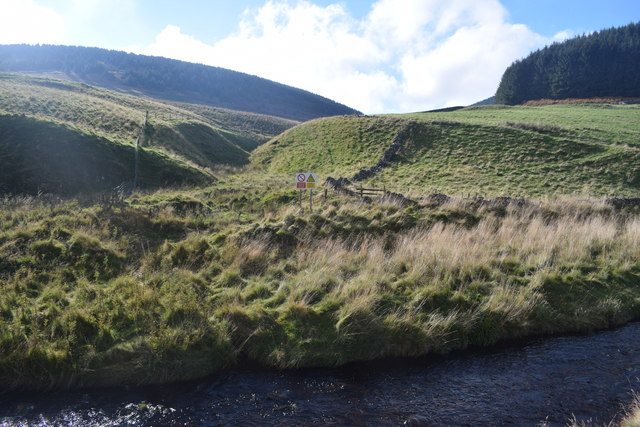
Bell Hill is a prominent hill located in the county of Northumberland, England. Standing at an elevation of approximately 180 meters (590 feet), it is situated in close proximity to the village of Warkworth. The hill is a part of the larger Northumberland National Park, renowned for its stunning natural beauty and diverse wildlife.

Bell Hill offers spectacular panoramic views of the surrounding landscape, including the picturesque Coquet Valley and the Northumberland coast. Its position on the edge of the national park provides visitors with an excellent vantage point to appreciate the region's rugged terrain and rolling hills.

The hill is accessible to hikers and nature enthusiasts through a network of well-maintained footpaths and trails. These routes cater to all levels of ability, making it an ideal destination for both experienced walkers and casual strollers. As visitors ascend Bell Hill, they are greeted by an abundance of flora and fauna, including heather, bilberry, and various species of birds and butterflies.

Notably, Bell Hill is also home to a prehistoric hillfort, which adds an intriguing historical element to the site. This ancient fortification dates back to the Iron Age and provides valuable insights into the region's rich archaeological heritage.

Overall, Bell Hill is a captivating natural feature that offers a delightful blend of scenic beauty, recreational opportunities, and historical significance. Whether one seeks a challenging hike, a peaceful stroll, or a glimpse into the past, this Northumberland gem is sure to leave a lasting impression on all who visit.

If you have any feedback on the listing, please let us know in the comments section below.

Bell Hill Images

Images are sourced within 2km of 55.384443/-2.2496197 or Grid Reference NT8410. Thanks to Geograph Open Source API. All images are credited.

Ordnance Survey Cut Mark This OS cut mark can be found on a roadside building at Blindburn. It marks a point 307.403m above mean sea level.
Ordnance Survey Cut Mark
This OS cut mark can be found on a roadside building at Blindburn. It marks a point 307.403m above mean sea level.
Archaeological Area Gatepost warning at Buckham's Bridge to troops exercising on MOD-owned land not to dig holes or drive over the land to avoid damage to known archaeological sites. Walking around with a rifle is fine.
Archaeological Area
Gatepost warning at Buckham's Bridge to troops exercising on MOD-owned land not to dig holes or drive over the land to avoid damage to known archaeological sites. Walking around with a rifle is fine.
View towards Bell Hill Downstream on the Coquet from Carshope.
View towards Bell Hill
Downstream on the Coquet from Carshope.
Part of Upper Coquetdale On the dead-end road out of Alwinton.
Part of Upper Coquetdale
On the dead-end road out of Alwinton.
Footbridge over the River Coquet Near Carlcroft.
Footbridge over the River Coquet
Near Carlcroft.
Ford on the River Coquet Between Blindburn and Carlcroft.
Ford on the River Coquet
Between Blindburn and Carlcroft.
Buckham's Bridge Where the Buckham's Walls Burn (in the foreground) meets the River Coquet.
Buckham's Bridge
Where the Buckham's Walls Burn (in the foreground) meets the River Coquet.
Blind Burn below Broadside Law
Footbridge over Blind Burn Carshope Plantation can be seen behind.
Footbridge over Blind Burn
Carshope Plantation can be seen behind.
Blindburn Cottages from the rear The cottages at Blindburn Farm were built in modern times, around 1950. There is a view of the front of the building from Blindburn Bridge here <a href="https://www.geograph.org.uk/photo/3957071">NT8310 : Blind Burn</a>

Carshope Plantation can be seen behind.

"Adieu to thee, Blindburn, sae lone! upon thae braes sae green
Thy sheep now bask the livelong day aneath the brent hill-side;
And pleasant is the e'enin' hour, and pleasant is the scene
To watch the herd wend owre the sward at gloamin' eventide."

From The Angler's Adieu for the Season in The Coquetdale Fishing Songs by Thomas Doubleday ed. (1852).
Blindburn Cottages from the rear
The cottages at Blindburn Farm were built in modern times, around 1950. There is a view of the front of the building from Blindburn Bridge here NT8310 : Blind Burn Carshope Plantation can be seen behind. "Adieu to thee, Blindburn, sae lone! upon thae braes sae green Thy sheep now bask the livelong day aneath the brent hill-side; And pleasant is the e'enin' hour, and pleasant is the scene To watch the herd wend owre the sward at gloamin' eventide." From The Angler's Adieu for the Season in The Coquetdale Fishing Songs by Thomas Doubleday ed. (1852).
Blindburn farmhouse "In a deep pool [on the Coquet] at Blindburn, locally called the 'Maskin' (named after a 'maskin-pot', an old name for a tea-pot), a large brown trout was caught a few years ago, weighing no less than seven pounds. It is an established fact amongst anglers that there is always a big trout in Blindburn pool. Blindburn House is picturesquely situated on the north bank of the Coquet, close to where the streamlet that gives it its name enters the main stream. Steep and lofty hills close it in on all sides."
Upper Coquetdale by David Dippie Dixon (1903), p.17

"An early 19th century farmhouse, built in about 1830."
<span class="nowrap"><a title="http://www.keystothepast.info/article/10339/Site-Details?PRN=N13918" rel="nofollow ugc noopener" href="http://www.keystothepast.info/article/10339/Site-Details?PRN=N13918">Link</a><img style="margin-left:2px;" alt="External link" title="External link - shift click to open in new window" src="https://s1.geograph.org.uk/img/external.png" width="10" height="10"/></span>

The small stable block probably of the same age is shown here <a href="https://www.geograph.org.uk/photo/99696">NT8210 : Blindburn Farm</a>
Blindburn farmhouse
"In a deep pool [on the Coquet] at Blindburn, locally called the 'Maskin' (named after a 'maskin-pot', an old name for a tea-pot), a large brown trout was caught a few years ago, weighing no less than seven pounds. It is an established fact amongst anglers that there is always a big trout in Blindburn pool. Blindburn House is picturesquely situated on the north bank of the Coquet, close to where the streamlet that gives it its name enters the main stream. Steep and lofty hills close it in on all sides." Upper Coquetdale by David Dippie Dixon (1903), p.17 "An early 19th century farmhouse, built in about 1830." LinkExternal link The small stable block probably of the same age is shown here NT8210 : Blindburn Farm
Hitachi CG-70 at Blindburn Farm The Hitachi CG-70 is a tracked dumper truck made in Japan in the 1990s.
Hitachi CG-70 at Blindburn Farm
The Hitachi CG-70 is a tracked dumper truck made in Japan in the 1990s.
Rectangular enclosure by Blind Burn
The Coquet below Tindale Law Road and river are close together through this narrow part of Upper Coquetdale.
The Coquet below Tindale Law
Road and river are close together through this narrow part of Upper Coquetdale.
Rocky outcrop above the Rowhope Burn This tiny outcrop is just below the well-trodden cross-border track known as The Street and lies on the steep slopes that sweep down to the Rowhope Burn. The hill on the left of the photograph is Barrow Law with Saughy Hill to its right and then, further right, Shillhope Law. For a selection of detailed free to download walking routes in the area visit <span class="nowrap"><a title="www.cheviotwalks.co.uk" rel="nofollow ugc noopener" href="http://www.cheviotwalks.co.uk">Link</a><img style="margin-left:2px;" alt="External link" title="External link - shift click to open in new window" src="https://s1.geograph.org.uk/img/external.png" width="10" height="10"/></span>
Rocky outcrop above the Rowhope Burn
This tiny outcrop is just below the well-trodden cross-border track known as The Street and lies on the steep slopes that sweep down to the Rowhope Burn. The hill on the left of the photograph is Barrow Law with Saughy Hill to its right and then, further right, Shillhope Law. For a selection of detailed free to download walking routes in the area visit LinkExternal link
Buckham's Bridge over the River Coquet The cattle seem to like the grazing around here.
Buckham's Bridge over the River Coquet
The cattle seem to like the grazing around here.
Crag beside Buckham's Bridge The debris caught in the protective fence around a sapling.
The River Coquet, in the foreground, has recently flooded.
Crag beside Buckham's Bridge
The debris caught in the protective fence around a sapling. The River Coquet, in the foreground, has recently flooded.
The River Coquet In its gorge east of Carshope.
A buzzard flew off as we stopped!
The River Coquet
In its gorge east of Carshope. A buzzard flew off as we stopped!
Show me another place!

Bell Hill is located at Grid Ref: NT8410 (Lat: 55.384443, Lng: -2.2496197)

Unitary Authority: Northumberland

Police Authority: Northumbria

What 3 Words

///creamed.marble.unimpeded. Near Rochester, Northumberland

Related Wikis

Barrow Burn

Barrowburn is a hamlet in Upper Coquetdale in the county of Northumberland, England. It comprises a working farm with associated buildings and two holiday...

Barrow Burn Meadows

Barrow Burn Meadows is a Site of Special Scientific Interest (SSSI) in north Northumberland, England. The site is a species-rich hay meadow of a sort now...

Shillhope Law

Shillhope Law is a hill in the southern Cheviots, a range of hills in Northumberland, England. Shillhope Law is a relatively unremarkable member of this...

Usway Burn

The Usway Burn is an upland river on the southern flanks of the Cheviot Hills, in the Northumberland National Park, England. It is a tributary of the River...

Featherwood Roman Camps

Featherwood Roman Camps are neighbouring archaeological sites in Northumberland, England, 1 mile (1.6 km) north of Featherwood and about 3 miles (5 km...

Windy Gyle

Windy Gyle is a mountain in the Cheviot Hills range, on the border between England and Scotland. Like the other hills in the area, it is rounded and grass...

Chew Green

Chew Green is the site of the ancient Roman encampment, commonly but erroneously called Ad Fines (Latin: The Limits) on the 1885-1900 edition of the Ordnance...

Kidland

Kidland is a former civil parish, now in the parish of Alwinton in Northumberland, England, about 2 miles (3 km) northwest of Alwinton village. In 1951...

Nearby Amenities

Located within 500m of 55.384443,-2.2496197
Bell Hill
Place: locality
Lat/Long: 55.3840171/-2.2492081
The data included in this document is from www.openstreetmap.org. The data is made available under ODbL.

Have you been to Bell Hill?

Leave your review of Bell Hill below (or comments, questions and feedback).