Keenthorne

Settlement in Somerset Sedgemoor

England

Keenthorne

Church Tower of St Martin's Church, Fiddington
Church Tower of St Martin's Church, Fiddington Credit: Adrian and Janet Quantock

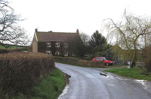
Keenthorne is a small village located in the county of Somerset, England. Situated approximately 11 miles west of the town of Bridgwater, Keenthorne falls within the Sedgemoor district. This picturesque village is nestled amidst the rolling hills of the Quantock Hills, an Area of Outstanding Natural Beauty.

With a population of around 200 residents, Keenthorne offers a tranquil and rural setting, perfect for those seeking a peaceful escape from the hustle and bustle of city life. The village is characterized by charming old stone cottages, surrounded by lush green fields and meadows.

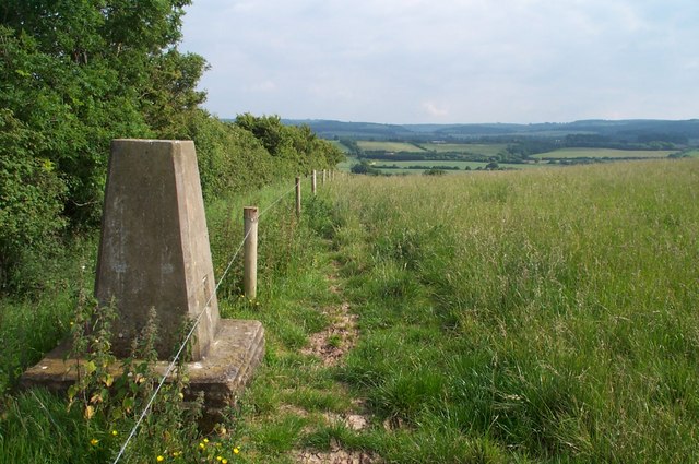
Keenthorne is well-known for its close proximity to a number of popular walking trails and nature reserves, making it a haven for outdoor enthusiasts. The Quantock Hills offer an extensive network of footpaths and bridleways, allowing visitors to explore the stunning countryside and enjoy breathtaking views of the surrounding area.

Despite its small size, Keenthorne is not lacking in amenities. The village is home to a local pub, providing a friendly and welcoming atmosphere for both residents and visitors. Additionally, the nearby town of Bridgwater offers a wider range of amenities, including shops, supermarkets, schools, and healthcare facilities.

Overall, Keenthorne is a charming village that offers a peaceful and idyllic lifestyle for its residents. Its natural beauty and proximity to the Quantocks make it an attractive destination for those seeking a rural getaway or a base for exploring the stunning Somerset countryside.

If you have any feedback on the listing, please let us know in the comments section below.

Keenthorne Images

Images are sourced within 2km of 51.144791/-3.1307241 or Grid Reference ST2139. Thanks to Geograph Open Source API. All images are credited.

Church Tower of St Martin's Church, Fiddington
O.S. Triangulation Point at Pinnacle Hill Not really a pinnacle, but tremendous views from the summit 95 metres above sea level.There is a new permissive path around the hill, with views of the Bristol Channel and the Quantocks.
O.S. Triangulation Point at Pinnacle Hill
Not really a pinnacle, but tremendous views from the summit 95 metres above sea level.There is a new permissive path around the hill, with views of the Bristol Channel and the Quantocks.
Fiddington Church
Fiddington Church
Feed hopper and bird rearing pens near Fiddington
Fields near Fiddington Quantock Hills in the distance
Fields near Fiddington
Quantock Hills in the distance
Quantock Lakes wedding venue and restaurant
The Cottage Inn by A39 near Keenthorne
Sign for nurseries by A39
Fiddington: St. Martin's Church
Ordnance Survey Cut Mark This OS cut mark can be found on the SE face of St Martin's Church. It marks a point 28.280m above mean sea level.
Ordnance Survey Cut Mark
This OS cut mark can be found on the SE face of St Martin's Church. It marks a point 28.280m above mean sea level.
Winter cereals, Fiddington
Wide verge, Fiddington An informal open space.
Wide verge, Fiddington
An informal open space.
Old Direction Sign - Signpost by Church Road, Fiddington Pyramid finial - 1 arm; Somerset SCC pyramid by the UC road, in parish of Fiddington (Sedgemoor District), Church Road junction with Whitnell Lane.

Surveyed

Milestone Society National ID: SO_ST2140
Old Direction Sign - Signpost by Church Road, Fiddington
Pyramid finial - 1 arm; Somerset SCC pyramid by the UC road, in parish of Fiddington (Sedgemoor District), Church Road junction with Whitnell Lane. Surveyed Milestone Society National ID: SO_ST2140
Industrial Unit near Whitnell
Little Halseycross Farm
Show me another place!

Keenthorne is located at Grid Ref: ST2139 (Lat: 51.144791, Lng: -3.1307241)

Administrative County: Somerset

District: Sedgemoor

Police Authority: Avon and Somerset

What 3 Words

///ideals.organs.pitching. Near Nether Stowey, Somerset

Nearby Locations

Whitnell Keenthorne

Related Wikis

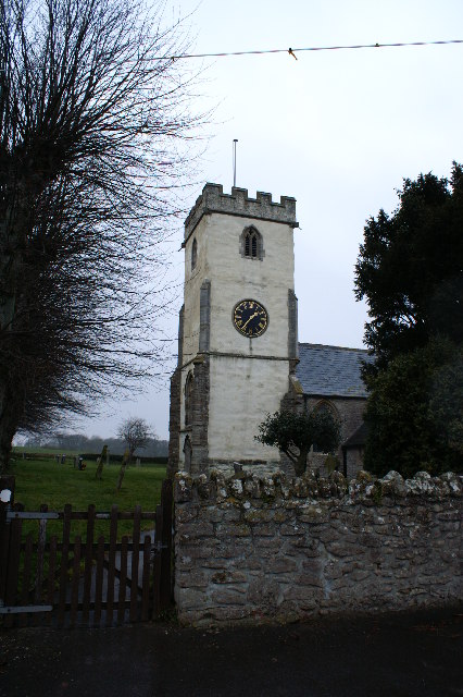
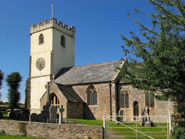
Church of St Mary the Virgin, Nether Stowey

The Anglican Church of St Mary the Virgin in Nether Stowey in the English county of Somerset has a 15th-century tower, with the remainder of the church...

Fiddington

Fiddington is a village and civil parish 2.5 miles (4 km) north-east of Nether Stowey, and 6 miles (10 km) north-west of Bridgwater in Somerset, England...

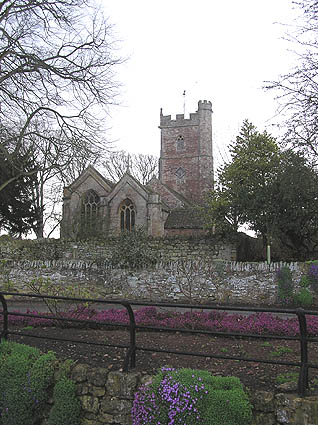
Church of St Martin, Fiddington

The Anglican Church of St Martin in Fiddington within the English county of Somerset dates from the 11th century and has been designated by English Heritage...

Nether Stowey

Nether Stowey is a large village in Somerset, South West England. It sits in the foothills of the Quantock Hills (England's first Area of Outstanding Natural...

Over Stowey

Over Stowey is a small village and civil parish in Somerset, South West England. A large part of the forest and open heath of the Quantock Hills is within...

Coleridge Cottage

Coleridge Cottage is a cottage situated in Nether Stowey, Bridgwater, Somerset, England. It is a grade II* listed building. The 17th century cottage was...

Spaxton

Spaxton is a small village and civil parish on the Quantocks in Somerset, South West England. == History == The name of Spaxton may originate from "Spakr...

Stowey Castle

Stowey Castle (or Nether Stowey Castle known locally as The Mount) was a Norman motte-and-bailey castle, built in the 11th century, in the village of Nether...

Nearby Amenities

Located within 500m of 51.144791,-3.1307241
Give Way
Lat/Long: 51.1462203/-3.1299204
Pub
The Cottage Inn
Is In: Somerset, England, UK
Lat/Long: 51.1466273/-3.1289788
Power: tower
Lat/Long: 51.1473517/-3.1252172
Give Way
Lat/Long: 51.1465597/-3.1286674
Give Way
Lat/Long: 51.1460844/-3.1304256
Give Way
Lat/Long: 51.1462421/-3.1304175
Power: tower
Lat/Long: 51.1477741/-3.1257176
Post Box
Brand: Royal Mail
Brand Wikidata: Q638098
Brand Wikipedia: en:Royal Mail
Operator: Royal Mail
Operator Wikidata: Q638098
Post Box Type: lamp
Ref: TA5 49
Royal Cypher: EIIR
Royal Cypher Wikidata: Q33102113
Lat/Long: 51.1460402/-3.1304504
Power: pole
Lat/Long: 51.1448203/-3.137337
Power: pole
Lat/Long: 51.144726/-3.1362346
Power: pole
Lat/Long: 51.146969/-3.1251302
Power: pole
Lat/Long: 51.145909/-3.124406
Power: pole
Lat/Long: 51.1449801/-3.1237328
Power: pole
Lat/Long: 51.1436878/-3.1248862
Power: pole
Lat/Long: 51.1438174/-3.1262407
Power: pole
Lat/Long: 51.1439209/-3.127449
Power: pole
Lat/Long: 51.1440412/-3.1287096
Power: pole
Lat/Long: 51.1441598/-3.130028
Power: pole
Lat/Long: 51.144387/-3.1325626
Power: pole
Lat/Long: 51.1445056/-3.1337911
Power: pole
Lat/Long: 51.1446192/-3.1350611
Power: pole
Lat/Long: 51.1419747/-3.1302264
Power: pole
Lat/Long: 51.1428279/-3.1302077
Power: pole
Lat/Long: 51.143671/-3.1308487
Power: pole
Lat/Long: 51.1442683/-3.1312859
Power: pole
Lat/Long: 51.1454328/-3.1307548
Power: pole
Lat/Long: 51.1463818/-3.1303123
Power: pole
Lat/Long: 51.1475066/-3.1297946
Power: pole
Lat/Long: 51.1477481/-3.1281745
Entrance: main
Lat/Long: 51.1465736/-3.128933
The data included in this document is from www.openstreetmap.org. The data is made available under ODbL.

Have you been to Keenthorne?

Leave your review of Keenthorne below (or comments, questions and feedback).