Birks Hill

Hill, Mountain in Yorkshire Richmondshire

England

Birks Hill

Barn in field on east side of B6259 at junction with footpath to How Beck Bridge The barn is now losing its roof: compare with 2013 photo <a href="https://www.geograph.org.uk/photo/3771178">SD7895 : Barn beside B6259 opposite White Birch Cottage</a>
Barn in field on east side of B6259 at junction with footpath to How Beck Bridge Credit: Luke Shaw

Birks Hill is a prominent hill located in the county of Yorkshire, England. Situated in the beautiful countryside of Yorkshire Dales National Park, this hill is a popular destination for outdoor enthusiasts, nature lovers, and hikers alike. Rising to an elevation of approximately 500 meters (1,640 feet), Birks Hill offers breathtaking panoramic views of the surrounding landscape.

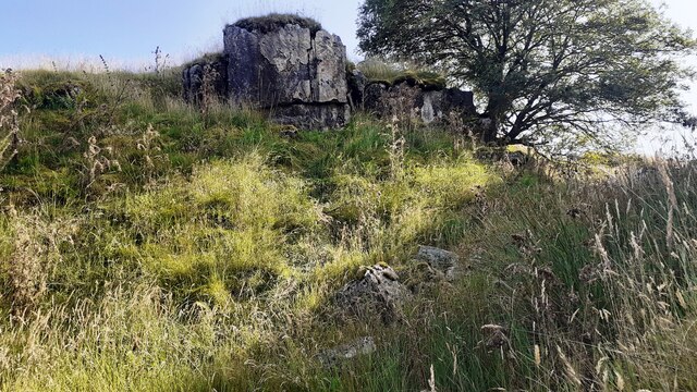
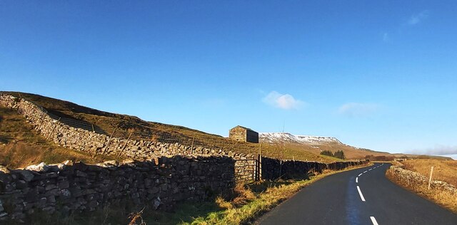
The hill is known for its rolling hills, lush green meadows, and charming villages that dot the countryside. The terrain is primarily composed of limestone, which gives the area its characteristic rugged and rocky appearance. Visitors to Birks Hill can expect to encounter a variety of natural features such as limestone pavements, dry stone walls, and picturesque valleys.

The hill is home to a diverse range of flora and fauna, including rare species of plants and animals. It is a designated Site of Special Scientific Interest (SSSI) due to its ecological importance. Visitors may spot a wide array of wildlife, including birds of prey, sheep, and small mammals as they explore the hill's trails and paths.

Hikers and walkers are drawn to Birks Hill due to its extensive network of well-maintained footpaths and trails. These routes cater to all levels of fitness and provide opportunities to explore the hill at one's own pace. Whether it's a leisurely stroll or a more challenging hike, Birks Hill offers something for everyone.

Overall, Birks Hill in Yorkshire is a picturesque and captivating destination that showcases the natural beauty and charm of the Yorkshire Dales. Its stunning vistas, rich biodiversity, and numerous outdoor activities make it a must-visit location for those seeking a memorable experience in the English countryside.

If you have any feedback on the listing, please let us know in the comments section below.

Birks Hill Images

Images are sourced within 2km of 54.36134/-2.3232691 or Grid Reference SD7996. Thanks to Geograph Open Source API. All images are credited.

Barn in field on east side of B6259 at junction with footpath to How Beck Bridge The barn is now losing its roof: compare with 2013 photo <a href="https://www.geograph.org.uk/photo/3771178">SD7895 : Barn beside B6259 opposite White Birch Cottage</a>
Barn in field on east side of B6259 at junction with footpath to How Beck Bridge
The barn is now losing its roof: compare with 2013 photo SD7895 : Barn beside B6259 opposite White Birch Cottage
Rock outcrop and rowan tree on SE bank of Far Cote Gill The 1898 1:2500 Map shows an Ordnance Survey benchmark levelled at 1277.4 feet above Liverpool Datum near here, but unable to locate it
Rock outcrop and rowan tree on SE bank of Far Cote Gill
The 1898 1:2500 Map shows an Ordnance Survey benchmark levelled at 1277.4 feet above Liverpool Datum near here, but unable to locate it
Looking down Far Cote Gill to bridge taking B6259 over Settle-Carlisle Railway
Sheepfolds on east side of Hell Gill
Track heading down towards Shaw Paddock Old Maps from 1853 to 1957 show an Ordnance Survey benchmark levelled at 1142.5 feet above Liverpool Datum at the left hand side of the track here.
Track heading down towards Shaw Paddock
Old Maps from 1853 to 1957 show an Ordnance Survey benchmark levelled at 1142.5 feet above Liverpool Datum at the left hand side of the track here.
How Beck Bridge taking track over River Ure
Green Bridge taking bridleway over moorland stream
Lime kiln at Hell Gill Green
Waterfall on Hell Gill Beck
Lime Kiln at High Way, on north side of bridleway
Hell Gill Beck north of Sour Hill
Looking SW along Hell Gill Beck north of Sour Hill
Looking NE along Hell Gill Beck
Valley with Hell Gill Beck
New forestry on west bank of Hell Gill Beck seen over wall of sheepfold Is that a meadow pipit on the wall?
New forestry on west bank of Hell Gill Beck seen over wall of sheepfold
Is that a meadow pipit on the wall?
Shaw Paddock Farm
Shaw Paddock Farm
Poly-wrapped Bales near Shaw Paddock
The B6259 near White Birch Cottage
Show me another place!

Birks Hill is located at Grid Ref: SD7996 (Lat: 54.36134, Lng: -2.3232691)

Division: North Riding

Administrative County: North Yorkshire

District: Richmondshire

Police Authority: North Yorkshire

What 3 Words

///denim.gets.heightens. Near Kirkby Stephen, Cumbria

Nearby Locations

Red Shaws Birks Hill

Related Wikis

Eden Sike Cave

Eden Sike Cave is a small cave in Mallerstang in the Eden valley in Cumbria, England 400 metres (440 yd) north of Hell Gill. The entrance is 391 metres...

Aisgill

Aisgill is the southernmost of the hamlets that form the parish of Mallerstang in the English county of Cumbria. It is on the B6259 road, at the head of...

Lunds, North Yorkshire

Lunds is a hamlet in North Yorkshire, England, near to the watershed of the Eden and Ure rivers. It is on the border between Cumbria and North Yorkshire...

1913 Ais Gill rail accident

The Ais Gill rail accident occurred on the Settle–Carlisle line in Northwest England on 2 September 1913. Two long trains were both ascending a steep gradient...

Nearby Amenities

Located within 500m of 54.36134,-2.3232691
Hell Gill Green
Natural: fell
Source: OS OpenData StreetView
Lat/Long: 54.3639295/-2.3288199
Black Hill
Natural: peak
Source: OS OpenData StreetView
Lat/Long: 54.3655172/-2.3238631
Ford: yes
Lat/Long: 54.3618067/-2.325443
Natural: sinkhole
Lat/Long: 54.3646251/-2.3277385
Natural: sinkhole
Lat/Long: 54.3647521/-2.3280776
Natural: sinkhole
Lat/Long: 54.3646064/-2.3278212
Natural: sinkhole
Lat/Long: 54.3642166/-2.3276372
Natural: sinkhole
Lat/Long: 54.3641042/-2.3276014
Natural: sinkhole
Lat/Long: 54.3639892/-2.3276058
Natural: sinkhole
Lat/Long: 54.3638689/-2.3276014
Natural: sinkhole
Lat/Long: 54.3635082/-2.3274847
Natural: sinkhole
Lat/Long: 54.3633044/-2.3273726
Natural: sinkhole
Lat/Long: 54.3630848/-2.3271169
Natural: sinkhole
Lat/Long: 54.3631659/-2.3271931
Natural: sinkhole
Lat/Long: 54.362894/-2.3268971
Natural: sinkhole
Lat/Long: 54.3627241/-2.326767
Natural: sinkhole
Lat/Long: 54.362549/-2.3264888
Natural: sinkhole
Lat/Long: 54.3609043/-2.3231358
Natural: sinkhole
Lat/Long: 54.3605414/-2.3234434
Natural: sinkhole
Lat/Long: 54.3603578/-2.3233458
Natural: sinkhole
Lat/Long: 54.3602573/-2.3233308
Natural: sinkhole
Lat/Long: 54.3600168/-2.3232558
Natural: sinkhole
Lat/Long: 54.3598114/-2.3230832
Natural: sinkhole
Lat/Long: 54.3593567/-2.3226106
Natural: sinkhole
Lat/Long: 54.359125/-2.3224005
Natural: sinkhole
Lat/Long: 54.358972/-2.3222729
Natural: sinkhole
Lat/Long: 54.3583774/-2.3212526
Natural: sinkhole
Lat/Long: 54.3582331/-2.3212076
Natural: sinkhole
Lat/Long: 54.3581151/-2.3203898
Natural: sinkhole
Lat/Long: 54.3581413/-2.3200221
Natural: sinkhole
Lat/Long: 54.3580364/-2.3198421
Natural: sinkhole
Lat/Long: 54.3579533/-2.319752
Natural: sinkhole
Lat/Long: 54.3578134/-2.3197745
Natural: sinkhole
Lat/Long: 54.357844/-2.3199696
The data included in this document is from www.openstreetmap.org. The data is made available under ODbL.

Have you been to Birks Hill?

Leave your review of Birks Hill below (or comments, questions and feedback).