Black Hill

Hill, Mountain in Yorkshire Ribble Valley

England

Black Hill

St Bartholomew’s Church, Tosside For information about this village church, see <a href="https://www.geograph.org.uk/photo/6861270">SD7656 : St Bartholomew, Tosside</a>. St Bartholomew’s had been decorated for the Queen’s Platinum Jubilee.
St Bartholomew’s Church, Tosside Credit: Mary and Angus Hogg

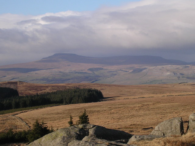
Black Hill is a prominent hill located in the northern part of the Peak District National Park in Yorkshire, England. Rising to an elevation of 582 meters (1,909 feet), it is one of the highest peaks in the region and offers breathtaking panoramic views of the surrounding landscape.

Situated near the village of Holmfirth, Black Hill is composed of millstone grit, a coarse-grained rock that gives the hill its distinctive dark appearance. The hill is known for its wild and rugged terrain, characterized by peat bogs, heather moorland, and scattered rocky outcrops.

Black Hill is a popular destination for hikers, walkers, and nature enthusiasts who are drawn to its natural beauty and challenging trails. The Pennine Way, a long-distance footpath that stretches over 400 kilometers (250 miles) from Derbyshire to Scotland, passes close to the summit of Black Hill, attracting many avid walkers.

The hill is home to a variety of wildlife, including grouse, golden plovers, and curlews, which thrive in the moorland habitat. Visitors may also spot red deer and hares roaming the hillsides.

Despite its natural beauty, Black Hill has a dark history. In the early 20th century, the hill was extensively used for peat cutting, resulting in widespread environmental damage. Efforts have since been made to restore the area, including the blocking of drainage channels and the creation of new peat bogs to promote the growth of sphagnum moss.

Overall, Black Hill offers a unique blend of natural beauty, challenging terrain, and historical significance, making it a must-visit destination for outdoor enthusiasts and those seeking to explore the diverse landscapes of Yorkshire.

If you have any feedback on the listing, please let us know in the comments section below.

Black Hill Images

Images are sourced within 2km of 54.013498/-2.3736243 or Grid Reference SD7557. Thanks to Geograph Open Source API. All images are credited.

St Bartholomew’s Church, Tosside For information about this village church, see <a href="https://www.geograph.org.uk/photo/6861270">SD7656 : St Bartholomew, Tosside</a>. St Bartholomew’s had been decorated for the Queen’s Platinum Jubilee.
St Bartholomew’s Church, Tosside
For information about this village church, see SD7656 : St Bartholomew, Tosside. St Bartholomew’s had been decorated for the Queen’s Platinum Jubilee.
Tosside, was The Dog and Partridge PH The OS Flush Bracket 10830 is embedded in the south-east facing wall of the building which was previously the village pub.
Tosside, was The Dog and Partridge PH
The OS Flush Bracket 10830 is embedded in the south-east facing wall of the building which was previously the village pub.
Tosside, was The Dog and Partridge PH The OS Flush Bracket 10830 is embedded into the south-east facing wall of the building, which was previously the village pub. The faded stones above the access door is where the pub name was attached to the wall.
Tosside, was The Dog and Partridge PH
The OS Flush Bracket 10830 is embedded into the south-east facing wall of the building, which was previously the village pub. The faded stones above the access door is where the pub name was attached to the wall.
Tosside, Longtons Farm There is a benchmark cut into the stone to the right of the brown pipe. It is partially obscured by the low wall and only part of the datum line and arrowhead can be seen.
Tosside, Longtons Farm
There is a benchmark cut into the stone to the right of the brown pipe. It is partially obscured by the low wall and only part of the datum line and arrowhead can be seen.
Tosside, Longtons Farm There is a benchmark cut into the stone to the right of the drainpipe. It is partially obscured by the low wall and only part of the datum line and arrowhead can be seen when stood on the roadside.
Tosside, Longtons Farm
There is a benchmark cut into the stone to the right of the drainpipe. It is partially obscured by the low wall and only part of the datum line and arrowhead can be seen when stood on the roadside.
Tosside, roadside barn The benchmark is cut into a left cornerstone of a barn on the south side of B6478.
Tosside, roadside barn
The benchmark is cut into a left cornerstone of a barn on the south side of B6478.
Tosside, roadside barn There is a benchmark cut into a left cornerstone of the road facing wall of the barn on the south side of B6478.
Tosside, roadside barn
There is a benchmark cut into a left cornerstone of the road facing wall of the barn on the south side of B6478.
Tosside, Chapel House Chapel House is west of Tosside on north side of B6478. There is a benchmark cut into the right hand gatepost to the property.
Tosside, Chapel House
Chapel House is west of Tosside on north side of B6478. There is a benchmark cut into the right hand gatepost to the property.
Gisburn Forest track A left turn to the north makes this easy-going teack a little harder as it is now gently uphill. Most of the forestry tracks are like this - low gradient and not too challenging for those on mountain bikes so old that suspension was not deemed necessary (at my age I want all the power I can generate to go into actual forward progress, not into compressing shock absorbers).
Gisburn Forest track
A left turn to the north makes this easy-going teack a little harder as it is now gently uphill. Most of the forestry tracks are like this - low gradient and not too challenging for those on mountain bikes so old that suspension was not deemed necessary (at my age I want all the power I can generate to go into actual forward progress, not into compressing shock absorbers).
Looking over Bottoms Beck A gap in the trees to the east of the track allows a view over Bottoms Beck to the clearing morning mists towards Hesbert Hall.
Looking over Bottoms Beck
A gap in the trees to the east of the track allows a view over Bottoms Beck to the clearing morning mists towards Hesbert Hall.
Hesbert Hall The forest track runs alongside a seriously thistle-infested field at Hesbert Hall with the extensive Gisburn Forest surrounding it - a few colouring larches, but mostly evergreen non-native conifers (Sitka spruce, Picea sitchensis, being the majority).
Hesbert Hall
The forest track runs alongside a seriously thistle-infested field at Hesbert Hall with the extensive Gisburn Forest surrounding it - a few colouring larches, but mostly evergreen non-native conifers (Sitka spruce, Picea sitchensis, being the majority).
Track past Heath Farm's barn The track leads from Gisburn Forest to Heath Farm, where the footpath splits, one way heading east to Longtons Lane, whilst the other heads much further to the north to Gigglewick Common.
Track past Heath Farm's barn
The track leads from Gisburn Forest to Heath Farm, where the footpath splits, one way heading east to Longtons Lane, whilst the other heads much further to the north to Gigglewick Common.
Timber trucks at the sawmill on Bailey Lane One empty, one full of logs from the surrounding Gisburn Forest. Bailey Lane itself is a substantial forestry track, followed by a public footpath, but widely used by cyclists, which are encouraged by the forestry operation.
Timber trucks at the sawmill on Bailey Lane
One empty, one full of logs from the surrounding Gisburn Forest. Bailey Lane itself is a substantial forestry track, followed by a public footpath, but widely used by cyclists, which are encouraged by the forestry operation.
Pond in Skirden Hall Plantation The lower of two apparnetly dammed ponds in Skirden Hall Plantation which is now part of the extensive Gisburn Forest. They both lie east of a track which seems little-used by mountain bikers, as it ends in a gate marked as private with no right of way.
Pond in Skirden Hall Plantation
The lower of two apparnetly dammed ponds in Skirden Hall Plantation which is now part of the extensive Gisburn Forest. They both lie east of a track which seems little-used by mountain bikers, as it ends in a gate marked as private with no right of way.
Track at Moss End I seemed to be the only mountain biker using this track, which isn't really a through route for cyclists, but dog walkers using the public right of way can continue east to the minor road by deviating from the track before it meets a gate marked "private, no public access". This view looks back towards Skirden Hall Plantation and a route to join other forest tracks and bike trails.
Track at Moss End
I seemed to be the only mountain biker using this track, which isn't really a through route for cyclists, but dog walkers using the public right of way can continue east to the minor road by deviating from the track before it meets a gate marked "private, no public access". This view looks back towards Skirden Hall Plantation and a route to join other forest tracks and bike trails.
Track to Moss End One of an extensive network of forest tracks in Gisburn Forest, many of which are popular with mountain bikers, but this one seems neglected. This is not entirely unsurprising since a short distance behind the photographer, the track is gated and marked "private, no public access". Just ahead, but not very obvious on the ground, a public footpath crosses the track, and this does give access past Skirden Hall to the minor road to the east, but, obviously, not for cyclists.
Track to Moss End
One of an extensive network of forest tracks in Gisburn Forest, many of which are popular with mountain bikers, but this one seems neglected. This is not entirely unsurprising since a short distance behind the photographer, the track is gated and marked "private, no public access". Just ahead, but not very obvious on the ground, a public footpath crosses the track, and this does give access past Skirden Hall to the minor road to the east, but, obviously, not for cyclists.
Footpath to White Hill House A small car park on a corner of School Lane (room for four cars, maybe five if carefully packed) serves this rather wet and muddy footpath heading into Gisburn Forest. The forest is popular with off-road cyclists, but this trail is one of those explicitly signed with a cycling prohibition which suited me fine - I wanted a nice wide track, thanks, and headed a little further south for my ride.
Footpath to White Hill House
A small car park on a corner of School Lane (room for four cars, maybe five if carefully packed) serves this rather wet and muddy footpath heading into Gisburn Forest. The forest is popular with off-road cyclists, but this trail is one of those explicitly signed with a cycling prohibition which suited me fine - I wanted a nice wide track, thanks, and headed a little further south for my ride.
View of Ingleborough from Whelp Stone Crag From the Millstone Grit south of the Craven fault to the  Carboniferous Limestone to the north. Fell Beck can just be made out terminating in Gaping Gill.
View of Ingleborough from Whelp Stone Crag
From the Millstone Grit south of the Craven fault to the Carboniferous Limestone to the north. Fell Beck can just be made out terminating in Gaping Gill.
Show me another place!

Black Hill is located at Grid Ref: SD7557 (Lat: 54.013498, Lng: -2.3736243)

Division: West Riding

Administrative County: Lancashire

District: Ribble Valley

Police Authority: Lancashire

What 3 Words

///swaps.cyclones.tapers. Near Settle, North Yorkshire

Related Wikis

Tosside

Tosside is a small village on the modern border of North Yorkshire and Lancashire in Northern England. It lies within the Forest of Bowland, and is between...

Easington, Lancashire

Easington () is a civil parish within the Ribble Valley district of Lancashire, England, with a population in 2001 of 52. The Census 2011 population details...

Gisburn Forest

Gisburn Forest is a civil parish in the Ribble Valley, in Lancashire, England. Mainly lying within the Forest of Bowland Area of Outstanding Natural Beauty...

Stocks Reservoir

Stocks Reservoir is a reservoir situated at the head of the Hodder valley in the Forest of Bowland, Lancashire, England (historically in the West Riding...

Nearby Amenities

Located within 500m of 54.013498,-2.3736243
Ford: yes
Lat/Long: 54.0129594/-2.371315
The data included in this document is from www.openstreetmap.org. The data is made available under ODbL.

Have you been to Black Hill?

Leave your review of Black Hill below (or comments, questions and feedback).