Bill's Hill

Hill, Mountain in Northumberland

England

Bill's Hill

Forestry road near Henshaw Common
Forestry road near Henshaw Common Credit: Steven Brown

Bill's Hill is a prominent geographical feature located in the county of Northumberland, England. Rising to an elevation of 456 meters (1,496 feet), it is classified as a hill rather than a mountain. Situated in the northern part of the county, Bill's Hill forms part of the picturesque landscape that characterizes the region.

The hill offers stunning panoramic views of the surrounding countryside, providing visitors with a glimpse of the breathtaking natural beauty that Northumberland has to offer. Its elevated position allows for unobstructed vistas of rolling green hills, vast valleys, and the meandering River Tyne, which winds its way through the landscape below.

Access to Bill's Hill is relatively straightforward, with several walking trails and footpaths leading up to its summit. The routes are well-maintained and cater to both experienced hikers and casual walkers alike. Along the way, visitors can enjoy the abundance of flora and fauna, including wildflowers and various bird species that call the area home.

Bill's Hill is also steeped in history, with remnants of ancient settlements and structures scattered across its slopes. Archaeological evidence suggests human habitation in the area dating back thousands of years, making it of significant historical and cultural importance.

Overall, Bill's Hill in Northumberland is a captivating natural landmark that encapsulates the region's beauty and heritage. Whether it be for a leisurely stroll or a challenging hike, visitors are sure to be captivated by the stunning views and rich history that this hill has to offer.

If you have any feedback on the listing, please let us know in the comments section below.
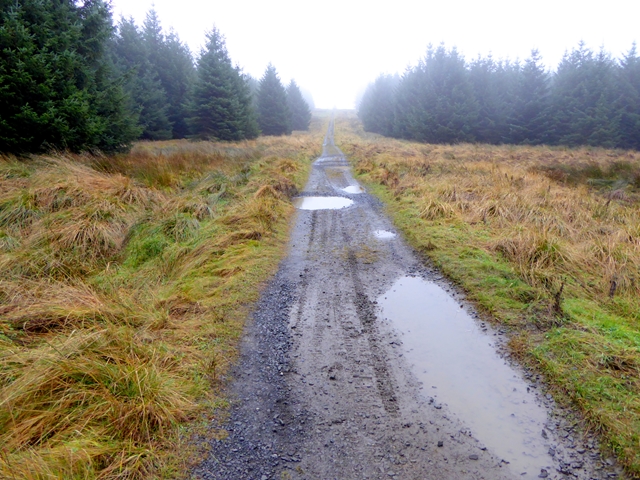
Bill's Hill Images

Images are sourced within 2km of 55.042914/-2.412383 or Grid Reference NY7372. Thanks to Geograph Open Source API. All images are credited.

Forestry road near Henshaw Common
Rocky land west of Robinrock Plantations
Forestry track, Robinrock Plantations Heading into the southern edge of the vast Wark/Kielder Forest is this track which is also a public footpath.
Forestry track, Robinrock Plantations
Heading into the southern edge of the vast Wark/Kielder Forest is this track which is also a public footpath.
Forest path, Robinrock Rigg The broad forest ride and track end here and a public footpath leads on through densely packed conifers towards Haughtongreen. Little was I to know that a few days later I would be at the other end of this path (reached by a different route).
Forest path, Robinrock Rigg
The broad forest ride and track end here and a public footpath leads on through densely packed conifers towards Haughtongreen. Little was I to know that a few days later I would be at the other end of this path (reached by a different route).
Robin Rock Drift None of the buildings shown on the maps exist any longer at this former coal mining site. I found a few lumps of poor quality coal.
Robin Rock Drift
None of the buildings shown on the maps exist any longer at this former coal mining site. I found a few lumps of poor quality coal.
Track through Wark Forest With the status of byway, this track carries National Cycle Network route 68 (the Pennine Cycleway). The surface of the track has deteriorated in recent years, and there are altogether too many puddles. Seen on a dreich day.
Track through Wark Forest
With the status of byway, this track carries National Cycle Network route 68 (the Pennine Cycleway). The surface of the track has deteriorated in recent years, and there are altogether too many puddles. Seen on a dreich day.
Open land in Wark Forest At Buckbog Syke.
Open land in Wark Forest
At Buckbog Syke.
A particularly large puddle With the status of byway, this track carries National Cycle Network route 68 (the Pennine Cycleway). The surface of the track has deteriorated in recent years, and there are altogether too many puddles. An old field wall can be seen to the left of the track, and an old gatepost stands close to the puddle.
A particularly large puddle
With the status of byway, this track carries National Cycle Network route 68 (the Pennine Cycleway). The surface of the track has deteriorated in recent years, and there are altogether too many puddles. An old field wall can be seen to the left of the track, and an old gatepost stands close to the puddle.
Ford at Tod Syke With the status of a public road, this track carries National Cycle Network route 68 (the Pennine Cycleway). The surface of the track has deteriorated in recent years, and there are altogether too many puddles.  But what looks here like a super-sized puddle is in fact a stream; fortunately a nearby footbridge has been built.
Ford at Tod Syke
With the status of a public road, this track carries National Cycle Network route 68 (the Pennine Cycleway). The surface of the track has deteriorated in recent years, and there are altogether too many puddles. But what looks here like a super-sized puddle is in fact a stream; fortunately a nearby footbridge has been built.
Waymark in Wark Forest With the status of a public road, this track carries National Cycle Network route 68 (the Pennine Cycleway). The marker indicates a public footpath, and also the logo of the Alternative Pennine Way. The APW is a strictly unofficial long distance walk from Ashbourne to Jedburgh, the subject of a Cicerone Guide published in 1992. It avoids much of the higher, boggier parts of the Pennine Way proper, but is little known and little walked. This is the only waymark for the APW that I have ever seen.
Waymark in Wark Forest
With the status of a public road, this track carries National Cycle Network route 68 (the Pennine Cycleway). The marker indicates a public footpath, and also the logo of the Alternative Pennine Way. The APW is a strictly unofficial long distance walk from Ashbourne to Jedburgh, the subject of a Cicerone Guide published in 1992. It avoids much of the higher, boggier parts of the Pennine Way proper, but is little known and little walked. This is the only waymark for the APW that I have ever seen.
The sorry remnants of Grindon Green A long-abandoned homestead in the middle of Wark Forest.
The sorry remnants of Grindon Green
A long-abandoned homestead in the middle of Wark Forest.
Hopealone telecommunications mast This mast was originally constructed as part of the national Early Warning system. It is now a vital part of BT's telecommunications network. I don't have any information on how tall it is, but it is pretty tall.
Hopealone telecommunications mast
This mast was originally constructed as part of the national Early Warning system. It is now a vital part of BT's telecommunications network. I don't have any information on how tall it is, but it is pretty tall.
Building at Hopealone This building was probably part of the original homestead at Hopealone - possibly a barn. It is now within the enclosure of the telecommunications mast, and may be used as part of the facilities there.
Building at Hopealone
This building was probably part of the original homestead at Hopealone - possibly a barn. It is now within the enclosure of the telecommunications mast, and may be used as part of the facilities there.
Hope Rigg Forest road in Wark Forest. Signs have been posted warning of ongoing forest operations.
Hope Rigg
Forest road in Wark Forest. Signs have been posted warning of ongoing forest operations.
Forest road at Bill's Hill The land to the right of the road has been cleared at some point in the last four years (see <a href="https://www.geograph.org.uk/photo/3201265">NY7372 : Forest road at Bill's Hill</a>).
Forest road at Bill's Hill
The land to the right of the road has been cleared at some point in the last four years (see NY7372 : Forest road at Bill's Hill).
Drainage work at Grindon Green Being a Sunday, the machinery is idle.
Drainage work at Grindon Green
Being a Sunday, the machinery is idle.
Windthrow in Wark Forest A scene of utter devastation near Grindon Green. When one shallow-rooted Sitka Spruce blows over, they all go.
Windthrow in Wark Forest
A scene of utter devastation near Grindon Green. When one shallow-rooted Sitka Spruce blows over, they all go.
Windthrow in Wark Forest The rootballs of trees felled by the wind have thrown up a  substantial barrier along the edge of the plantation at Giant Hill.
Windthrow in Wark Forest
The rootballs of trees felled by the wind have thrown up a substantial barrier along the edge of the plantation at Giant Hill.
Show me another place!

Bill's Hill is located at Grid Ref: NY7372 (Lat: 55.042914, Lng: -2.412383)

Unitary Authority: Northumberland

Police Authority: Northumbria

What 3 Words

///pesky.audible.remainder. Near Haltwhistle, Northumberland

Related Wikis

Milecastle 40

Milecastle 40 (Winshields) was a milecastle on Hadrian's Wall (grid reference NY74566758). == Description == Milecastle 40 is located northwest of Twice...
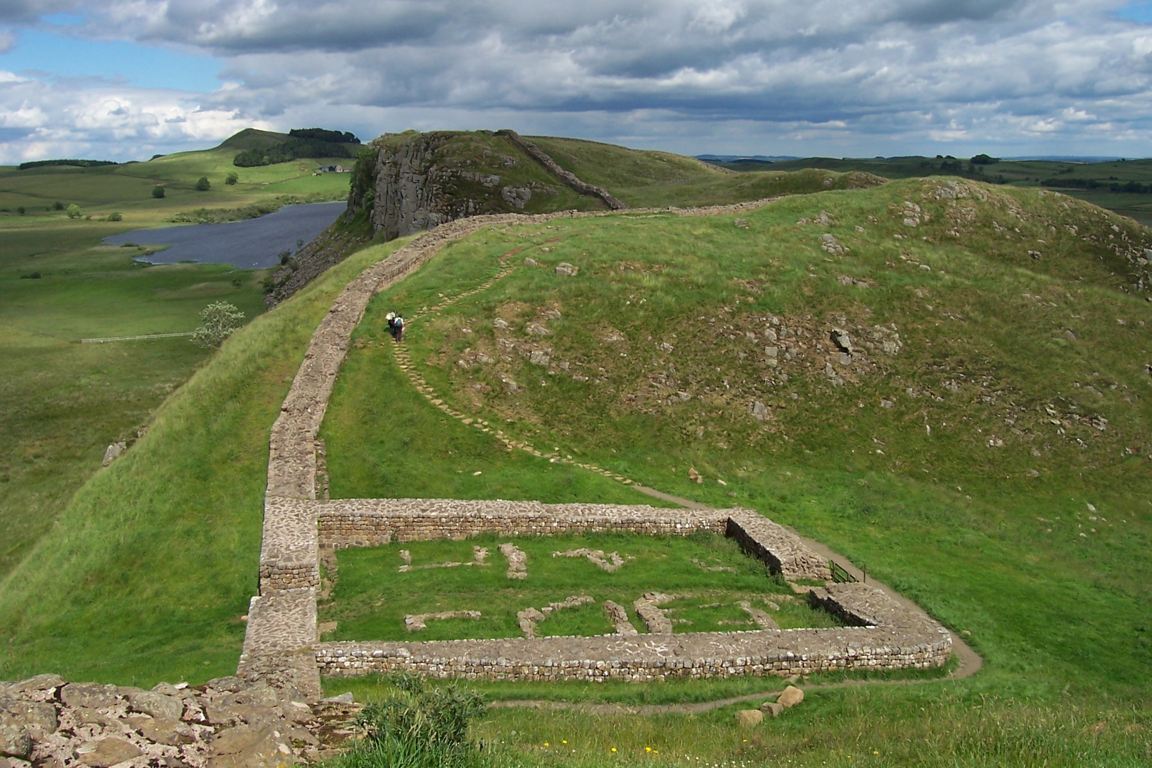
Milecastle 39

Milecastle 39 (Castle Nick) is a milecastle on Hadrian's Wall (grid reference NY76066773). == Description == Milecastle 39 is located northeast of Once...

Once Brewed

Once Brewed (also known as Twice Brewed or Once Brewed/Twice Brewed) is a village in Northumberland, England. It lies on the Military Road (Northumberland...

Sycamore Gap Tree

The Sycamore Gap Tree or Robin Hood Tree was a sycamore tree standing next to Hadrian's Wall near Crag Lough in Northumberland, England. It was located...

Nearby Amenities

Located within 500m of 55.042914,-2.412383
Hopealone
Place: locality
Lat/Long: 55.0401258/-2.4172636
Tower Type: communication
Lat/Long: 55.0398594/-2.4173352
Hopealone
Man Made: tower
Tower Type: communication
Lat/Long: 55.0398749/-2.4163913
Bill's Hill
Place: locality
Lat/Long: 55.0429926/-2.413321
Hope Hill
Ele: 316m
Place: locality
Lat/Long: 55.0414699/-2.4086769
The data included in this document is from www.openstreetmap.org. The data is made available under ODbL.

Have you been to Bill's Hill?

Leave your review of Bill's Hill below (or comments, questions and feedback).