Broom Hill

Hill, Mountain in Westmorland Eden

England

Broom Hill

Looking towards High Cup Gill from near Harbour Flatt, Appleby
Looking towards High Cup Gill from near Harbour Flatt, Appleby Credit: habiloid

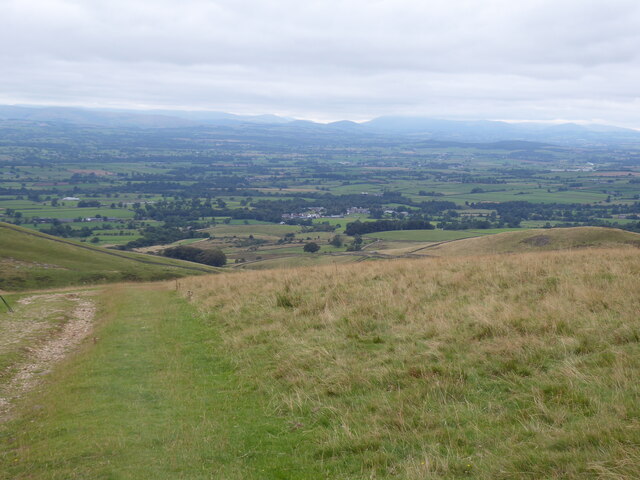
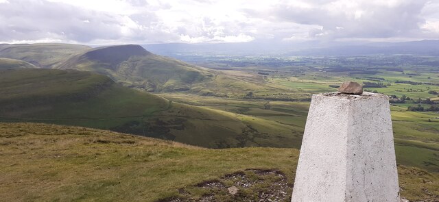
Broom Hill is a prominent hill located in the county of Westmorland, England. Situated within the picturesque Lake District National Park, it stands at an elevation of approximately 342 meters (1,122 feet) above sea level. The hill is known for its distinct conical shape and offers panoramic views of the surrounding countryside.

Covered in lush green vegetation, Broom Hill is a haven for nature enthusiasts and hikers. It boasts a variety of flora and fauna, including heather, grasses, and wildflowers, attracting an array of bird species and other small animals. The hill is also home to several walking trails that cater to all abilities, providing an opportunity to explore its natural beauty.

The summit of Broom Hill provides stunning vistas of the nearby fells and valleys, including the famous Lake Windermere. On clear days, visitors can see as far as the Cumbrian coast and even catch a glimpse of Scotland in the distance. The hill's strategic location makes it a popular spot for photographers, who can capture breathtaking sunsets and the ever-changing play of light over the landscape.

Broom Hill holds historical significance as well, with evidence of ancient settlements and stone circles in the surrounding area. Its tranquil setting and rich history make it a site of interest for those seeking a deeper understanding of the region's past.

Overall, Broom Hill, Westmorland is a stunning natural landmark that offers a blend of natural beauty, recreational activities, and historical exploration. Whether one wants to hike, take in the views, or delve into the area's history, Broom Hill provides a captivating experience for all who visit.

If you have any feedback on the listing, please let us know in the comments section below.

Broom Hill Images

Images are sourced within 2km of 54.601958/-2.4297533 or Grid Reference NY7223. Thanks to Geograph Open Source API. All images are credited.

Looking towards High Cup Gill from near Harbour Flatt, Appleby
Middletongue Crag
Middletongue Crag
View from Middletongue Crag
Bridge over Murton Beck, Murton
Copse south of Murton Beck This stand of trees (which we would have called a copse where I grew up, but they are not coppiced, so whether the term would apply here I'm less sure) occupies the corner of a field south of Murton Beck, the northern edge of which is followed by the public footpath from the Flakebridge road towards Murton, upon which the photographer and his trusty but dawdling hound are standing as the daylight fades (again).
Copse south of Murton Beck
This stand of trees (which we would have called a copse where I grew up, but they are not coppiced, so whether the term would apply here I'm less sure) occupies the corner of a field south of Murton Beck, the northern edge of which is followed by the public footpath from the Flakebridge road towards Murton, upon which the photographer and his trusty but dawdling hound are standing as the daylight fades (again).
Footbridge over Murton Beck The public footpath west from Murton splits here with one way remaining on the north bank of Murton Beck to turn northwards shortly, heading for Brackenthwaite, whilst the footbridge carries the other branch across the beck, to head west to Shepherd's Cottage and Flakebridge (and the end of a minor road to Appleby).
Footbridge over Murton Beck
The public footpath west from Murton splits here with one way remaining on the north bank of Murton Beck to turn northwards shortly, heading for Brackenthwaite, whilst the footbridge carries the other branch across the beck, to head west to Shepherd's Cottage and Flakebridge (and the end of a minor road to Appleby).
Track on lower slopes of Murton Pike
Trundale Adjacent valley to the more famous High Cup.
Trundale
Adjacent valley to the more famous High Cup.
Trundale Gill
Trundale Gill
View across lower part of High Cup valley
Middletongue Crag
Middletongue Crag
Trig Point on Murton Pike
Track on the slopes of Murton Pike
Cumbrian Red Sandstone house, Murton
The Pennine Way near Peeping Hill
Murton Pike Looking along the escarpment
Murton Pike
Looking along the escarpment
Trundale Gill Lots of Limestone scree along the valley. Just below Murton Pike
Trundale Gill
Lots of Limestone scree along the valley. Just below Murton Pike
Ordnance Survey Cut Mark This OS cut mark can be found on the toppled gatepost.
Ordnance Survey Cut Mark
This OS cut mark can be found on the toppled gatepost.
Show me another place!

Broom Hill is located at Grid Ref: NY7223 (Lat: 54.601958, Lng: -2.4297533)

Administrative County: Cumbria

District: Eden

Police Authority: Cumbria

What 3 Words

///jotting.quicksand.stole. Near Appleby-in-Westmorland, Cumbria

Nearby Locations

Broom Hill

Related Wikis

Keisley

Keisley is a small hamlet in the English county of Cumbria. It is located in the Dufton civil parish and the Eden district. == Location and geography... ==

Murton, Cumbria

Murton is a small village and civil parish in the Eden District of Cumbria, England. The parish had a population of 330 in 2001, rising to 360 at the 2011...

Flakebridge

Flakebridge is a woodland and small hamlet in the Eden District, Cumbria, England, 3 kilometres (1.9 mi) south-west from the village of Dufton and 1.95...

Hilton, Cumbria

Hilton is a village in Cumbria, England, in the civil parish of Murton, about 3 miles (4.8 km) east of Appleby-in-Westmorland and at an elevation of 752...

Nearby Amenities

Located within 500m of 54.601958,-2.4297533
High Clints
Place: locality
Lat/Long: 54.6030783/-2.4264109
Broom Hill
Place: locality
Lat/Long: 54.5997965/-2.4305944
Power: pole
Lat/Long: 54.6028472/-2.4372441
Power: pole
Lat/Long: 54.6028988/-2.435332
Power: pole
Lat/Long: 54.6029434/-2.4336948
The data included in this document is from www.openstreetmap.org. The data is made available under ODbL.

Have you been to Broom Hill?

Leave your review of Broom Hill below (or comments, questions and feedback).