Brownber Hill

Hill, Mountain in Westmorland Eden

England

Brownber Hill

The Pennine Way near Swindale Beck
The Pennine Way near Swindale Beck Credit: Dave Kelly

Brownber Hill is a prominent hill located in Westmorland, Cumbria, in the northwest region of England. Standing at an elevation of 546 meters (1,791 feet), it is classified as a hill rather than a mountain. Its coordinates are approximately 54.443°N latitude and 2.408°W longitude.

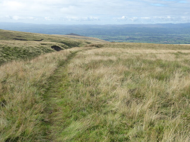
The hill is part of the larger Pennines range, which stretches across northern England. It is characterized by its rounded shape and gentle slopes, making it a relatively easy climb for hikers and outdoor enthusiasts. From the summit, visitors can enjoy breathtaking panoramic views of the surrounding countryside, including the picturesque Eden Valley and the distant Howgill Fells.

Brownber Hill is covered in a mixture of grasses and heather, with scattered patches of woodland throughout its lower slopes. The area is known for its rich biodiversity and is home to various species of flora and fauna. It is a popular spot for birdwatching, with the possibility of spotting birds of prey such as buzzards and kestrels soaring overhead.

The hill offers several walking routes, including a circular trail that takes in the summit and provides an opportunity to explore the diverse landscapes. The path is well-maintained, making it accessible to walkers of different skill levels.

Overall, Brownber Hill in Westmorland is a beautiful and accessible hill that offers stunning views and an opportunity to immerse oneself in the natural beauty of the region.

If you have any feedback on the listing, please let us know in the comments section below.

Brownber Hill Images

Images are sourced within 2km of 54.641875/-2.4573831 or Grid Reference NY7027. Thanks to Geograph Open Source API. All images are credited.

The Pennine Way near Swindale Beck
The Pennine Way near Knock Hush
Ordnance Survey Pivot This OS pivot can be found on a boulder. It marks a point 1319.4ft above mean sea level.
Ordnance Survey Pivot
This OS pivot can be found on a boulder. It marks a point 1319.4ft above mean sea level.
Ordnance Survey Cut Mark This OS cut mark can be found on the gatepost north side of the track. It marks a point 953.5ft above mean sea level.
Ordnance Survey Cut Mark
This OS cut mark can be found on the gatepost north side of the track. It marks a point 953.5ft above mean sea level.
Ordnance Survey Pivot This OS pivot can be found on the large boulder. It marks a point 1080.7ft above mean sea level.
Ordnance Survey Pivot
This OS pivot can be found on the large boulder. It marks a point 1080.7ft above mean sea level.
Ordnance Survey Pivot This OS pivot can be found on a boulder east of the track. It marks a point 1044.0ft above mean sea level.
Ordnance Survey Pivot
This OS pivot can be found on a boulder east of the track. It marks a point 1044.0ft above mean sea level.
Ordnance Survey Cut Mark This OS cut mark can be found on the gatepost SE side of the track. It marks a point 1273.0ft above mean sea level.
Ordnance Survey Cut Mark
This OS cut mark can be found on the gatepost SE side of the track. It marks a point 1273.0ft above mean sea level.
Ordnance Survey Pivot This OS pivot can be found on the north angle of the sheep fold. It marks a point 1444.6ft above mean sea level.
Ordnance Survey Pivot
This OS pivot can be found on the north angle of the sheep fold. It marks a point 1444.6ft above mean sea level.
Ordnance Survey Pivot This OS pivot can be found on the east face of the wall. It marks a point 1456.7ft above mean sea level.
Ordnance Survey Pivot
This OS pivot can be found on the east face of the wall. It marks a point 1456.7ft above mean sea level.
Ordnance Survey Pivot This OS pivot can be found on the boulder next to the wall. It marks a point 1451.4ft above mean sea level.
Ordnance Survey Pivot
This OS pivot can be found on the boulder next to the wall. It marks a point 1451.4ft above mean sea level.
Bridleway to Threlkeld Side The bridleway was used by the mines in the Great Rundale valley. The scar in the hillside on the right  is a hush - a man-made gorge formed by releasing the water from dammed streams, washing away the upper layers of earth to expose seams of ore.
Bridleway to Threlkeld Side
The bridleway was used by the mines in the Great Rundale valley. The scar in the hillside on the right is a hush - a man-made gorge formed by releasing the water from dammed streams, washing away the upper layers of earth to expose seams of ore.
Sheepfold below Dufton Pike At the east side of Dufton Pike beside a farm road two dry stone walls come together, meeting at an acute angle; by the addition of a little more walling this narrow sheepfold has been created.
Sheepfold below Dufton Pike
At the east side of Dufton Pike beside a farm road two dry stone walls come together, meeting at an acute angle; by the addition of a little more walling this narrow sheepfold has been created.
Brownber Hill Steep-sided Brownber Hill is seen across the valley of Great Rundale from the estate/mine road above the south side of the dale.
Brownber Hill
Steep-sided Brownber Hill is seen across the valley of Great Rundale from the estate/mine road above the south side of the dale.
Great Rundale Great Rundale is a significant slice into the western flank of the north Pennines. Historically it's seen much mineral mining and the valley is scarred both in the stretch visible here and in its upper reaches with the extensive remains of it. The view is from a mine and estate road on the valley's south side; it's line can be seen entering the right edge of the image. The black dot a short way along the road is a fine old lime kiln: <a title="https://www.geograph.org.uk/photo/1921590" href="https://www.geograph.org.uk/photo/1921590">Link</a>.
Great Rundale
Great Rundale is a significant slice into the western flank of the north Pennines. Historically it's seen much mineral mining and the valley is scarred both in the stretch visible here and in its upper reaches with the extensive remains of it. The view is from a mine and estate road on the valley's south side; it's line can be seen entering the right edge of the image. The black dot a short way along the road is a fine old lime kiln: Link.
Great Rundale, eroding hill slope Great Rundale has seen much mining activity in the past and some of the evidence is seen here, viewed from a track on the south side of the valley, above the main estate road through it. The steep eroded slope may or may not be mined and discarded material but a terrace below the upper rocks suggests that it is mine spoil dumped below from there. There are a number of remaining fragments of masonry which surely will soon be lost to the on-going erosion of the slope.
Great Rundale, eroding hill slope
Great Rundale has seen much mining activity in the past and some of the evidence is seen here, viewed from a track on the south side of the valley, above the main estate road through it. The steep eroded slope may or may not be mined and discarded material but a terrace below the upper rocks suggests that it is mine spoil dumped below from there. There are a number of remaining fragments of masonry which surely will soon be lost to the on-going erosion of the slope.
Trig point above Backstone Edge The trig point seen here (known to the OS as 'Dufton'), is not at  the local high point but perhaps 250m to the south-west of it; the trig point location is given as 692m - 7m lower. The view is generally to the north where Cross Fell, the Dun Fells and Knock Fell are seen.
Note: Listings of two thousand foot hills generally name the 'peak' here as Backstone Edge but that name actually refers to an horizon of the western slope of the mountain to the south of both the trig and the true summit; in all probability, this hill is effectively nameless.
Further Note: The trig point has been robbed of its bronze flush bracket; the cavity can be seen.
Trig point above Backstone Edge
The trig point seen here (known to the OS as 'Dufton'), is not at the local high point but perhaps 250m to the south-west of it; the trig point location is given as 692m - 7m lower. The view is generally to the north where Cross Fell, the Dun Fells and Knock Fell are seen. Note: Listings of two thousand foot hills generally name the 'peak' here as Backstone Edge but that name actually refers to an horizon of the western slope of the mountain to the south of both the trig and the true summit; in all probability, this hill is effectively nameless. Further Note: The trig point has been robbed of its bronze flush bracket; the cavity can be seen.
Little Rundale Beck Little Rundale Beck runs in a shallow groove from high ground above; here its course is mainly through grass, higher it's significantly bouldery in places. Below, (to the left of the image), the fall of the stream steepens markedly and becomes extremely bouldery. The local high point lies in the direction of the view and is above the distant, shadowed ground; it's known generally as Backstone Edge but that name refers more properly to ground high on the hill on the camera side of Little Rundale Beck.
Little Rundale Beck
Little Rundale Beck runs in a shallow groove from high ground above; here its course is mainly through grass, higher it's significantly bouldery in places. Below, (to the left of the image), the fall of the stream steepens markedly and becomes extremely bouldery. The local high point lies in the direction of the view and is above the distant, shadowed ground; it's known generally as Backstone Edge but that name refers more properly to ground high on the hill on the camera side of Little Rundale Beck.
Boulders close to Little Rundale Beck The western face of the ground rising towards the hill known as Backstone Edge, to the east of Dufton is generally of steep grass with bands and areas of grey boulderiness. The slopes seen here below the camera position and to the south beyond the obvious slot of Little Rundale Beck show the extent of boulder cover.
Boulders close to Little Rundale Beck
The western face of the ground rising towards the hill known as Backstone Edge, to the east of Dufton is generally of steep grass with bands and areas of grey boulderiness. The slopes seen here below the camera position and to the south beyond the obvious slot of Little Rundale Beck show the extent of boulder cover.
Show me another place!

Brownber Hill is located at Grid Ref: NY7027 (Lat: 54.641875, Lng: -2.4573831)

Administrative County: Cumbria

District: Eden

Police Authority: Cumbria

What 3 Words

///gift.families.spenders. Near Appleby-in-Westmorland, Cumbria

Nearby Locations

Brownber Hill

Related Wikis

Dufton Pike

Dufton Pike is a hill in the northern Pennines, in Cumbria, England. It is classed as a Marilyn (a hill with topographic prominence of at least 150m)....

St Cuthbert's Church, Dufton

St Cuthbert's Church is situated 3⁄4 mile (1.2 km) north of the village of Dufton, Cumbria, England. It should not be confused with the nearby St Cuthbert...

Knock, Cumbria

Knock is a small village in the Eden district of Cumbria, England, and 1.9 km northwest of the larger village of Dufton and 3.1 km south of the village...

Dufton

Dufton is a village and civil parish in Cumbria, England. Historically part of Westmorland, it lies in the Eden Valley and below Great Dun Fell. It is...

High Cup Gill

High Cup Gill (or High Cup Nick or just High Cup), almost a geometrically perfect U-shaped chasm, is a valley deeply incised into the Pennine scarp to...

Keisley

Keisley is a small hamlet in the English county of Cumbria. It is located in the Dufton civil parish and the Eden district. == Location and geography... ==

Long Marton railway station

Long Marton railway station was a railway station which served the village of Long Marton in Cumbria, England. Situated on the Settle-Carlisle Line, it...

Long Marton

Long Marton is a village and civil parish in the Eden District of the English county of Cumbria. In 2011 the population was 827. The village previously...

Related Videos

Dufton Pike & High Cup Nick 2021

Two walk in one - Dufton Pike and High Cup Nick , only because I lost my GoPro 7 on my first walk so had to go back the next day ...

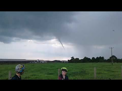
Tornado Twister over Cumbria 9th June 2018

Short video of a tornado on a bike ride.

Nearby Amenities

Located within 500m of 54.641875,-2.4573831
Threlkeld Side
Place: locality
Source: NPE
Lat/Long: 54.642118/-2.4506235
Brownber Hill
Natural: peak
Source: NPE
Lat/Long: 54.6418199/-2.4575543
Natural: sinkhole
Lat/Long: 54.6425613/-2.4500287
Abandoned: yes
Historic: mine_shaft
Man Made: mineshaft
Source: Bing
Lat/Long: 54.6425123/-2.4506305
Abandoned: yes
Historic: mine_shaft
Man Made: mineshaft
Source: Bing
Lat/Long: 54.6425012/-2.4512521
Abandoned: yes
Historic: mine_shaft
Man Made: mineshaft
Source: Bing
Lat/Long: 54.6424514/-2.4510322
Abandoned: yes
Historic: mine_shaft
Man Made: mineshaft
Source: Bing
Lat/Long: 54.6424984/-2.4509174
Abandoned: yes
Historic: mine_shaft
Man Made: mineshaft
Source: Bing
Lat/Long: 54.64247/-2.4526532
Abandoned: yes
Historic: mine_shaft
Man Made: mineshaft
Source: Bing
Lat/Long: 54.6422083/-2.4530701
Natural: sinkhole
Lat/Long: 54.6424005/-2.4504361
Natural: sinkhole
Lat/Long: 54.642477/-2.4502911
Natural: sinkhole
Lat/Long: 54.6425234/-2.4502975
Natural: sinkhole
Lat/Long: 54.6426923/-2.450227
Natural: sinkhole
Lat/Long: 54.6426811/-2.4503296
Natural: sinkhole
Lat/Long: 54.642709/-2.4503777
Natural: sinkhole
Lat/Long: 54.6427628/-2.4505573
Natural: sinkhole
Lat/Long: 54.642722/-2.4505926
Natural: sinkhole
Lat/Long: 54.6426459/-2.4504707
Natural: sinkhole
Lat/Long: 54.6426162/-2.4505317
Natural: sinkhole
Lat/Long: 54.6427238/-2.4508685
Abandoned: yes
Historic: mine_shaft
Man Made: mineshaft
Source: Bing
Lat/Long: 54.6427443/-2.4510107
Abandoned: yes
Historic: mine_shaft
Man Made: mineshaft
Source: Bing
Lat/Long: 54.6429206/-2.4509964
Natural: sinkhole
Lat/Long: 54.6440705/-2.4538621
Natural: sinkhole
Lat/Long: 54.6448924/-2.4541277
Natural: sinkhole
Lat/Long: 54.6451997/-2.4544279
Natural: sinkhole
Lat/Long: 54.6453333/-2.4544164
Natural: sinkhole
Lat/Long: 54.645614/-2.4546646
Natural: sinkhole
Lat/Long: 54.6446425/-2.4564315
Natural: sinkhole
Lat/Long: 54.6436161/-2.4555175
The data included in this document is from www.openstreetmap.org. The data is made available under ODbL.

Have you been to Brownber Hill?

Leave your review of Brownber Hill below (or comments, questions and feedback).