Bullman Hills

Hill, Mountain in Cumberland Eden

England

Bullman Hills

The Pennine Way looking towards Cross Fell
The Pennine Way looking towards Cross Fell Credit: Dave Kelly

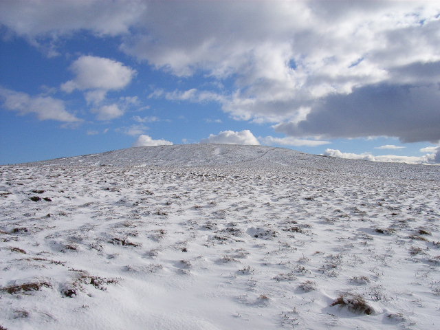
Bullman Hills, located in Cumberland, is a prominent hill/mountain that stands tall in the region. With its distinctive features and breathtaking views, it has become a popular destination for outdoor enthusiasts and nature lovers alike.

Rising to an elevation of approximately 1,200 feet, Bullman Hills offers a challenging terrain for hikers and climbers. Its rugged cliffs and steep slopes provide an exciting experience for adventure seekers looking for a thrilling climb. The hill/mountain is covered in dense forest, primarily consisting of oak, maple, and pine trees, adding to its natural beauty.

At the summit of Bullman Hills, visitors are rewarded with panoramic vistas that stretch for miles. On a clear day, one can see the surrounding Cumberland Valley, with its rolling hills and scenic landscapes. The breathtaking views make it an ideal spot for photography and picnics.

The area around Bullman Hills is also home to a diverse array of wildlife. Deer, foxes, squirrels, and various bird species can be spotted while exploring the trails. The presence of these animals adds to the allure of the hill/mountain and offers nature enthusiasts a chance to observe wildlife in its natural habitat.

Bullman Hills is equipped with well-maintained hiking trails that cater to different skill levels, ensuring that both beginners and experienced hikers can enjoy its beauty. The trails are marked with informative signposts, providing hikers with valuable information about the flora and fauna they may encounter along the way.

Overall, Bullman Hills in Cumberland is a remarkable natural landmark, offering a challenging yet rewarding outdoor experience for all who venture to explore its majestic slopes and captivating surroundings.

If you have any feedback on the listing, please let us know in the comments section below.

Bullman Hills Images

Images are sourced within 2km of 54.728023/-2.4595488 or Grid Reference NY7037. Thanks to Geograph Open Source API. All images are credited.

The Pennine Way looking towards Cross Fell
Pennine Way to Cross Fell The long trudge from Garrigill on the Pennine Way passes wayside relics of the former mining activity. This was a fine day - no sign of the notorious Helm wind.
Pennine Way to Cross Fell
The long trudge from Garrigill on the Pennine Way passes wayside relics of the former mining activity. This was a fine day - no sign of the notorious Helm wind.
The Pennine Way near Backstone Edge
The Pennine Way near Cash Well
The Pennine Way near Long Man Hill
Pennine Way snaking to the W of Long Man Hill above Garrigill
Old Boundary Marker on Rake Moss Parish Boundary Marker on Rake Moss, northeast of Cross Fell summit. On the boundary of Culgaith and Alston Moor parishes.

Milestone Society National ID: CU_CULALM10pb
Old Boundary Marker on Rake Moss
Parish Boundary Marker on Rake Moss, northeast of Cross Fell summit. On the boundary of Culgaith and Alston Moor parishes. Milestone Society National ID: CU_CULALM10pb
Old Boundary Marker on Rake Moss Parish Boundary Marker on Rake Moss, northeast of Cross Fell summit. On the boundary of Culgaith and Alston Moor parishes.

Milestone Society National ID: CU_CULALM11pb
Old Boundary Marker on Rake Moss
Parish Boundary Marker on Rake Moss, northeast of Cross Fell summit. On the boundary of Culgaith and Alston Moor parishes. Milestone Society National ID: CU_CULALM11pb
Slopes on north side of Cross Fell The north side of Cross Fell as seen from just below the Pennine Way as it approaches Greg's Hut.
Slopes on north side of Cross Fell
The north side of Cross Fell as seen from just below the Pennine Way as it approaches Greg's Hut.
Rock outcrop on Backstone Edge
Sheepfolds on Skirwith Fell This is a particularly large and complex set of sheepfolds, at a height of almost 2,200 feet on the moorland just to the north of Cross Fell - see the satellite image <span class="nowrap"><a title="http://wtp2.appspot.com/wheresthepath.htm?lat=54.714349062594564&lon=-2.479409873485565&gz=19&oz=8&gt=1" rel="nofollow ugc noopener" href="http://wtp2.appspot.com/wheresthepath.htm?lat=54.714349062594564&lon=-2.479409873485565&gz=19&oz=8&gt=1">Link</a><img style="margin-left:2px;" alt="External link" title="External link - shift click to open in new window" src="https://s1.geograph.org.uk/img/external.png" width="10" height="10"/></span> . Photo taken from near <a href="https://www.geograph.org.uk/photo/1840">NY6935 : Greg's Hut</a> (photographed by Andy Stephenson). The sheepfolds can also be seen in <a href="https://www.geograph.org.uk/photo/3177027">NY6935 : Skirwith Fell</a>.
Sheepfolds on Skirwith Fell
This is a particularly large and complex set of sheepfolds, at a height of almost 2,200 feet on the moorland just to the north of Cross Fell - see the satellite image LinkExternal link . Photo taken from near NY6935 : Greg's Hut (photographed by Andy Stephenson). The sheepfolds can also be seen in NY6935 : Skirwith Fell.
Greg's Hut A bothy high up on Cross Fell. Managed by the MBA.
Greg's Hut
A bothy high up on Cross Fell. Managed by the MBA.
View from Greg's Hut Looking NE.
View from Greg's Hut
Looking NE.
Cash Burn
Cash Burn
Cashwell Level, Rotherhope Fell An old Lead Mine at the side of the Pennine Way on the way from Garrigill to Cross Fell.
Cashwell Level, Rotherhope Fell
An old Lead Mine at the side of the Pennine Way on the way from Garrigill to Cross Fell.
Cash Burn, Rotherhope Fell Looking north
Cash Burn, Rotherhope Fell
Looking north
Cash Force Waterfall Not the easiest waterfall to get to but well worth it if you manage to get there.  On one of our visits we found a Dippers nest behind the waterfall.
Cash Force Waterfall
Not the easiest waterfall to get to but well worth it if you manage to get there. On one of our visits we found a Dippers nest behind the waterfall.
Long Man Hill
Long Man Hill
Show me another place!

Bullman Hills is located at Grid Ref: NY7037 (Lat: 54.728023, Lng: -2.4595488)

Administrative County: Cumbria

District: Eden

Police Authority: Cumbria

What 3 Words

///centuries.refer.crossings. Near Alston, Cumbria

Nearby Locations

Bullman Hills

Related Wikis

Cross Fell

Cross Fell is the highest mountain in the Pennines of Northern England and the highest point in England outside the Lake District. It is located in the...

Moorhouse and Cross Fell

Moorhouse and Cross Fell is a Site of Special Scientific Interest covering an extensive area of moorland in the Wear Valley district of west County Durham...

Garrigill

Garrigill, Cumbria is a small village in the North Pennine region of the UK, situated on the banks and close to the source of the River South Tyne. Historically...

Ashgill Force

Ashgill Force is a waterfall near Alston, Cumbria, England. The fall is located on Ashgill Beck and is reasonably easily accessible from the B6277 (which...

Nearby Amenities

Located within 500m of 54.728023,-2.4595488
Bullman Hills
Ele: 614
Natural: peak
Lat/Long: 54.7285944/-2.4590677
Natural: sinkhole
Lat/Long: 54.7276121/-2.4610797
Natural: sinkhole
Lat/Long: 54.7283533/-2.459558
Hunting Stand
Lat/Long: 54.727309/-2.4599097
Hunting Stand
Lat/Long: 54.7270397/-2.4598861
Hunting Stand
Lat/Long: 54.7267827/-2.4598826
Hunting Stand
Lat/Long: 54.7265358/-2.4598774
Hunting Stand
Lat/Long: 54.726301/-2.4598355
Hunting Stand
Lat/Long: 54.7260037/-2.4598373
Hunting Stand
Lat/Long: 54.7256489/-2.4598285
Hunting Stand
Lat/Long: 54.725305/-2.4598117
Hunting Stand
Lat/Long: 54.7249543/-2.4597891
Hunting Stand
Lat/Long: 54.7245701/-2.4597739
Hunting Stand
Lat/Long: 54.7265054/-2.4631338
Hunting Stand
Lat/Long: 54.7268647/-2.4631948
Hunting Stand
Lat/Long: 54.7271574/-2.4632187
Hunting Stand
Lat/Long: 54.7274225/-2.4632666
Abandoned: yes
Historic: lime_kiln
Lat/Long: 54.7273583/-2.4628506
Hunting Stand
Lat/Long: 54.7262054/-2.4631097
Hunting Stand
Lat/Long: 54.7259877/-2.463069
Hunting Stand
Lat/Long: 54.7257089/-2.4630419
Hunting Stand
Lat/Long: 54.7254019/-2.4629849
Hunting Stand
Lat/Long: 54.7250746/-2.4629551
Hunting Stand
Lat/Long: 54.7247668/-2.462934
The data included in this document is from www.openstreetmap.org. The data is made available under ODbL.

Have you been to Bullman Hills?

Leave your review of Bullman Hills below (or comments, questions and feedback).