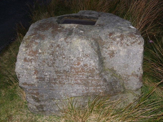
Catlow Hill

Hill, Mountain in Yorkshire Ribble Valley

England

Catlow Hill

Cross of Greet (woz 'ere) Pendle Hill still visible (just).
Cross of Greet (woz 'ere) Credit: Peter Turner

Catlow Hill is a prominent geographical feature located in the county of Yorkshire, England. Situated in the southern part of the county, it is classified as a hill rather than a mountain, with an elevation of approximately 276 meters (906 feet). The hill is part of the Pennine range, which stretches across northern England and forms the backbone of the country.

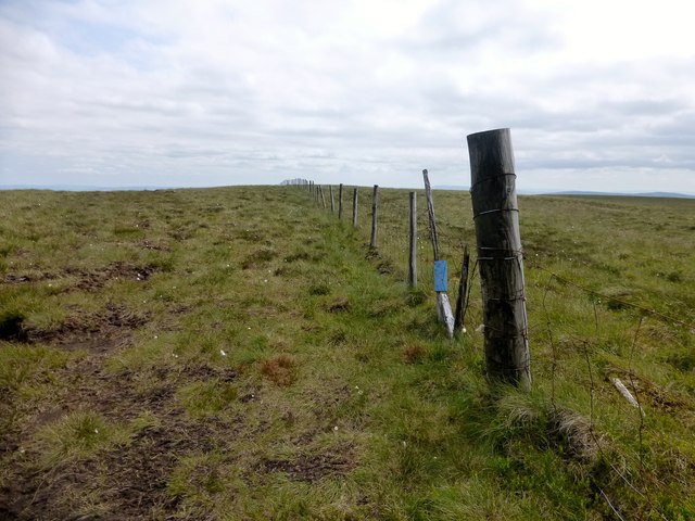
Catlow Hill is known for its picturesque scenery and is popular among hikers and nature enthusiasts. The hill offers breathtaking panoramic views of the surrounding countryside, with rolling green fields, scattered woodlands, and quaint villages dotting the landscape.

The area around Catlow Hill is rich in history and heritage. It is believed that the hill has been inhabited since ancient times, with evidence of human activity dating back to the Neolithic period. The hill has also played a significant role in local folklore and legends, adding to its mystique and allure.

In addition to its natural beauty, Catlow Hill is home to a diverse range of flora and fauna. The hillside supports a variety of plant species, including heather, bracken, and wildflowers, creating a vibrant and colorful display during the summer months. The area is also inhabited by various bird species, such as kestrels and buzzards, making it a haven for birdwatchers.

Overall, Catlow Hill is a cherished landmark in Yorkshire, offering visitors a chance to immerse themselves in the beauty of the English countryside while exploring its rich history and natural wonders.

If you have any feedback on the listing, please let us know in the comments section below.

Catlow Hill Images

Images are sourced within 2km of 54.035418/-2.4595065 or Grid Reference SD7060. Thanks to Geograph Open Source API. All images are credited.

Cross of Greet (woz 'ere) Pendle Hill still visible (just).
Cross of Greet (woz 'ere)
Pendle Hill still visible (just).
To Little Clough head
The road to Bentham With access point for a less speedy route to other places.
The road to Bentham
With access point for a less speedy route to other places.
At the Cross of Greet On the road from Slaidburn to Bentham. The cross is now gone, leaving only the base stone. The cross probably once marked the boundary between the Civil Parishes of Tatham and Slaidburn.
At the Cross of Greet
On the road from Slaidburn to Bentham. The cross is now gone, leaving only the base stone. The cross probably once marked the boundary between the Civil Parishes of Tatham and Slaidburn.
Cross of Greet The lonely Cross of Greet at dusk.
Cross of Greet
The lonely Cross of Greet at dusk.
The Cross 'O' Greet at Watter Shed Wurs't cross gone then? Musta gone long a go, wur't med a wood or stone, long long ago ?
The Cross 'O' Greet at Watter Shed
Wurs't cross gone then? Musta gone long a go, wur't med a wood or stone, long long ago ?
Remains of Cross of Greet - Tatham fell - Bowland
Moon from Cross of Greet
Night falling at Cross of Greet
On Reflection at Cross of Greet
Hailshowers Fell Parked after cattle grid at 427 metres at SD6823860865 then Great Harlow, Hailshowers Fell, Bowlands Knotts, return to Hailshowers Fell, Great Harlow, Thistle Hill, Burn Moor and then to road below Moor Cock Farm and then up road back to my car. Very hot sunny day with drier than average moorland underfoot. 486 metre point next to fence didn't seem to be the highest point walking either way over this hill today. A quad track seemed to stop at the highest point before a lower cairn, buried stake and grit point.
Name: Hailshowers Fell
Hill number: 108526
Height: 486m / 1594ft
Area: 36: Lancashire, Cheshire & the Southern Pennines
Class: 4
Grid ref: SD698608 (est)
Drop: 64m
Col: 422m
Hailshowers Fell
Parked after cattle grid at 427 metres at SD6823860865 then Great Harlow, Hailshowers Fell, Bowlands Knotts, return to Hailshowers Fell, Great Harlow, Thistle Hill, Burn Moor and then to road below Moor Cock Farm and then up road back to my car. Very hot sunny day with drier than average moorland underfoot. 486 metre point next to fence didn't seem to be the highest point walking either way over this hill today. A quad track seemed to stop at the highest point before a lower cairn, buried stake and grit point. Name: Hailshowers Fell Hill number: 108526 Height: 486m / 1594ft Area: 36: Lancashire, Cheshire & the Southern Pennines Class: 4 Grid ref: SD698608 (est) Drop: 64m Col: 422m
Hailshowers Fell Alternative Summit This spot above the cairn appeared to be as high or higher than the summit of Hailshowers Fell beside the fence on this hot sunny Sunday.  This hill high point is also called Great Harlow.
Hailshowers Fell Alternative Summit
This spot above the cairn appeared to be as high or higher than the summit of Hailshowers Fell beside the fence on this hot sunny Sunday. This hill high point is also called Great Harlow.
Raven's Castle The stile and wall junction at Raven's Castle.
Raven's Castle
The stile and wall junction at Raven's Castle.
Start Of Route Towards Hailshowers Fell The start of the route towards Hailshowers Fell is a little boggy.
Start Of Route Towards Hailshowers Fell
The start of the route towards Hailshowers Fell is a little boggy.
Heading Towards Hailshowers Fell The moorland has plenty of Cottongrass this year as I walk up towards Raven's Castle and then Hailshowers Fell.
Heading Towards Hailshowers Fell
The moorland has plenty of Cottongrass this year as I walk up towards Raven's Castle and then Hailshowers Fell.
Road descends to Slaidburn
Wooden structure on moor There are several of these. I think they are hides for shooters.
Wooden structure on moor
There are several of these. I think they are hides for shooters.
Valley of the River Hodder Looking south down the valley of the River Hodder with the Cross of Greet moorland road on the left
Valley of the River Hodder
Looking south down the valley of the River Hodder with the Cross of Greet moorland road on the left
Show me another place!

Catlow Hill is located at Grid Ref: SD7060 (Lat: 54.035418, Lng: -2.4595065)

Division: West Riding

Administrative County: Lancashire

District: Ribble Valley

Police Authority: Lancashire

What 3 Words

///cello.regal.recovery. Near High Bentham, North Yorkshire

Related Wikis

White Hill (Forest of Bowland)

White Hill is a hill in the Forest of Bowland, north-western England. It lies between Slaidburn and High Bentham. The summit houses a tower and a trig...

Geography of the United Kingdom

The United Kingdom is a sovereign state located off the north-western coast of continental Europe. With a total area of approximately 248,532 square kilometres...

Stocks Reservoir

Stocks Reservoir is a reservoir situated at the head of the Hodder valley in the Forest of Bowland, Lancashire, England (historically in the West Riding...

Easington, Lancashire

Easington () is a civil parish within the Ribble Valley district of Lancashire, England, with a population in 2001 of 52. The Census 2011 population details...

Nearby Amenities

Located within 500m of 54.035418,-2.4595065
Passing Place
Lat/Long: 54.0327701/-2.4644371
Passing Place
Lat/Long: 54.0337092/-2.4660632
The data included in this document is from www.openstreetmap.org. The data is made available under ODbL.

Have you been to Catlow Hill?

Leave your review of Catlow Hill below (or comments, questions and feedback).