Dufton Pike

Hill, Mountain in Westmorland Eden

England

Dufton Pike

The Pennine Way near Bow Hall
The Pennine Way near Bow Hall Credit: Dave Kelly

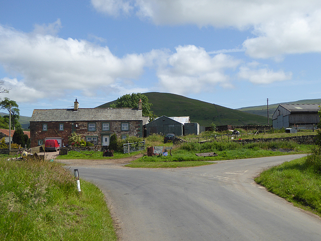
Dufton Pike is a prominent hill located in the county of Westmorland, Cumbria, England. Rising to an elevation of 481 meters (1,578 feet), it is a notable feature in the stunning Pennine landscape. The hill is situated near the village of Dufton, which lies approximately 3 kilometers (1.9 miles) to the southeast.

Dufton Pike is primarily composed of limestone, a characteristic that contributes to its distinct appearance. Its steep sides are covered with grass and heather, creating a vibrant and picturesque scene. The summit of the hill offers breathtaking panoramic views of the surrounding countryside, including the stunning Eden Valley and the nearby North Pennines.

The ascent to the summit of Dufton Pike is a popular excursion for hikers and outdoor enthusiasts. The hill is accessible via a well-maintained footpath that starts from the village of Dufton. The hike to the top usually takes around an hour, providing an enjoyable and relatively easy experience for visitors of varying fitness levels.

In addition to its natural beauty, Dufton Pike also holds historical significance. The hill is believed to have been used as a lookout point during the Roman era, providing vantage views for the nearby fort of Maglona.

Overall, Dufton Pike is a captivating landmark that offers both natural splendor and cultural heritage. Its accessibility, stunning vistas, and rich history make it a must-visit destination for those exploring the Westmorland region.

If you have any feedback on the listing, please let us know in the comments section below.

Dufton Pike Images

Images are sourced within 2km of 54.633905/-2.4664646 or Grid Reference NY6926. Thanks to Geograph Open Source API. All images are credited.

The Pennine Way near Bow Hall
Ordnance Survey Pivot This OS pivot can be found on a boulder. It marks a point 1319.4ft above mean sea level.
Ordnance Survey Pivot
This OS pivot can be found on a boulder. It marks a point 1319.4ft above mean sea level.
Ordnance Survey Cut Mark This OS cut mark can be found on the gatepost north side of the track. It marks a point 953.5ft above mean sea level.
Ordnance Survey Cut Mark
This OS cut mark can be found on the gatepost north side of the track. It marks a point 953.5ft above mean sea level.
Ordnance Survey Pivot This OS pivot can be found on the large boulder. It marks a point 1080.7ft above mean sea level.
Ordnance Survey Pivot
This OS pivot can be found on the large boulder. It marks a point 1080.7ft above mean sea level.
Ordnance Survey Pivot This OS pivot can be found on a boulder east of the track. It marks a point 1044.0ft above mean sea level.
Ordnance Survey Pivot
This OS pivot can be found on a boulder east of the track. It marks a point 1044.0ft above mean sea level.
Ordnance Survey Cut Mark This OS cut mark can be found on the gatepost SE side of the track. It marks a point 1273.0ft above mean sea level.
Ordnance Survey Cut Mark
This OS cut mark can be found on the gatepost SE side of the track. It marks a point 1273.0ft above mean sea level.
Ordnance Survey Pivot This OS pivot can be found on the north angle of the sheep fold. It marks a point 1444.6ft above mean sea level.
Ordnance Survey Pivot
This OS pivot can be found on the north angle of the sheep fold. It marks a point 1444.6ft above mean sea level.
Ordnance Survey Pivot This OS pivot can be found on the east face of the wall. It marks a point 1456.7ft above mean sea level.
Ordnance Survey Pivot
This OS pivot can be found on the east face of the wall. It marks a point 1456.7ft above mean sea level.
Ordnance Survey Pivot This OS pivot can be found on the boulder next to the wall. It marks a point 1451.4ft above mean sea level.
Ordnance Survey Pivot
This OS pivot can be found on the boulder next to the wall. It marks a point 1451.4ft above mean sea level.
Ordnance Survey Cut Mark This OS cut mark can be found on the gatepost at the track junction. It marks a point 1028.0ft above mean sea level.
Ordnance Survey Cut Mark
This OS cut mark can be found on the gatepost at the track junction. It marks a point 1028.0ft above mean sea level.
Ordnance Survey Cut Mark This OS cut mark can be found on the gatepost south side of the track. It marks a point 293m above mean sea level.
Ordnance Survey Cut Mark
This OS cut mark can be found on the gatepost south side of the track. It marks a point 293m above mean sea level.
Ordnance Survey Cut Mark This OS cut mark can be found on the gatepost south side of the track. It marks a point 853.5ft above mean sea level.
Ordnance Survey Cut Mark
This OS cut mark can be found on the gatepost south side of the track. It marks a point 853.5ft above mean sea level.
Milestone - Birkdale 6 Stone with the inscription 'Birkdale 6m'
Milestone - Birkdale 6
Stone with the inscription 'Birkdale 6m'
Bridleway to Threlkeld Side The bridleway was used by the mines in the Great Rundale valley. The scar in the hillside on the right  is a hush - a man-made gorge formed by releasing the water from dammed streams, washing away the upper layers of earth to expose seams of ore.
Bridleway to Threlkeld Side
The bridleway was used by the mines in the Great Rundale valley. The scar in the hillside on the right is a hush - a man-made gorge formed by releasing the water from dammed streams, washing away the upper layers of earth to expose seams of ore.
Sheepfold below Dufton Pike At the east side of Dufton Pike beside a farm road two dry stone walls come together, meeting at an acute angle; by the addition of a little more walling this narrow sheepfold has been created.
Sheepfold below Dufton Pike
At the east side of Dufton Pike beside a farm road two dry stone walls come together, meeting at an acute angle; by the addition of a little more walling this narrow sheepfold has been created.
Brownber Hill Steep-sided Brownber Hill is seen across the valley of Great Rundale from the estate/mine road above the south side of the dale.
Brownber Hill
Steep-sided Brownber Hill is seen across the valley of Great Rundale from the estate/mine road above the south side of the dale.
Great Rundale Great Rundale is a significant slice into the western flank of the north Pennines. Historically it's seen much mineral mining and the valley is scarred both in the stretch visible here and in its upper reaches with the extensive remains of it. The view is from a mine and estate road on the valley's south side; it's line can be seen entering the right edge of the image. The black dot a short way along the road is a fine old lime kiln: <a title="https://www.geograph.org.uk/photo/1921590" href="https://www.geograph.org.uk/photo/1921590">Link</a>.
Great Rundale
Great Rundale is a significant slice into the western flank of the north Pennines. Historically it's seen much mineral mining and the valley is scarred both in the stretch visible here and in its upper reaches with the extensive remains of it. The view is from a mine and estate road on the valley's south side; it's line can be seen entering the right edge of the image. The black dot a short way along the road is a fine old lime kiln: Link.
Boulders close to Little Rundale Beck The western face of the ground rising towards the hill known as Backstone Edge, to the east of Dufton is generally of steep grass with bands and areas of grey boulderiness. The slopes seen here below the camera position and to the south beyond the obvious slot of Little Rundale Beck show the extent of boulder cover.
Boulders close to Little Rundale Beck
The western face of the ground rising towards the hill known as Backstone Edge, to the east of Dufton is generally of steep grass with bands and areas of grey boulderiness. The slopes seen here below the camera position and to the south beyond the obvious slot of Little Rundale Beck show the extent of boulder cover.
Show me another place!

Dufton Pike is located at Grid Ref: NY6926 (Lat: 54.633905, Lng: -2.4664646)

Administrative County: Cumbria

District: Eden

Police Authority: Cumbria

What 3 Words

///expecting.ownership.indicate. Near Appleby-in-Westmorland, Cumbria

Nearby Locations

Dufton Pike

Related Wikis

Dufton Pike

Dufton Pike is a hill in the northern Pennines, in Cumbria, England. It is classed as a Marilyn (a hill with topographic prominence of at least 150m)....

St Cuthbert's Church, Dufton

St Cuthbert's Church is situated 3⁄4 mile (1.2 km) north of the village of Dufton, Cumbria, England. It should not be confused with the nearby St Cuthbert...

Dufton

Dufton is a village and civil parish in Cumbria, England. Historically part of Westmorland, it lies in the Eden Valley and below Great Dun Fell. It is...

Knock, Cumbria

Knock is a small village in the Eden district of Cumbria, England, and 1.9 km northwest of the larger village of Dufton and 3.1 km south of the village...

Nearby Amenities

Located within 500m of 54.633905,-2.4664646
Dufton Pike
Ele: 481.0
Natural: peak
Source: NPE
Wikidata: Q5312421
Wikipedia: en:Dufton Pike
Lat/Long: 54.6338783/-2.4665558
Ford: yes
Lat/Long: 54.6359986/-2.4621527
Barrier: stile
Lat/Long: 54.6355244/-2.4594626
Barrier: stile
Lat/Long: 54.6355902/-2.4606563
Information: guidepost
Tourism: information
Lat/Long: 54.637567/-2.4684937
The data included in this document is from www.openstreetmap.org. The data is made available under ODbL.

Have you been to Dufton Pike?

Leave your review of Dufton Pike below (or comments, questions and feedback).