Blackyduds

Hill, Mountain in Aberdeenshire

Scotland

Blackyduds

Track on Greymore Hill, Aberdeenshire
Track on Greymore Hill, Aberdeenshire Credit: Andrew Tryon

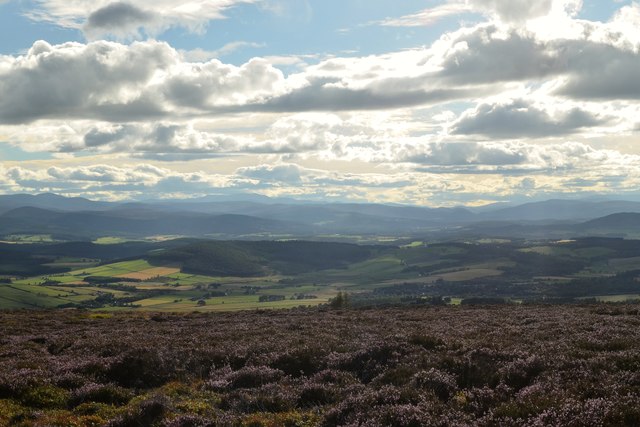
Blackyduds is a prominent hill/mountain located in Aberdeenshire, Scotland. It is situated in the eastern part of the county, near the village of Insch. Standing at an elevation of approximately 558 meters (1831 feet), Blackyduds offers stunning panoramic views of the surrounding countryside and is a popular destination for hikers and nature enthusiasts.

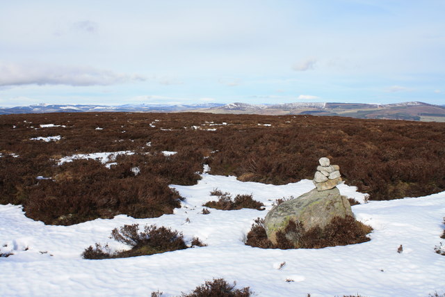
The hill/mountain is characterized by its rugged terrain, consisting mainly of heather-covered moorland and rocky outcrops. Its slopes are steep in some sections, providing a challenging ascent for experienced climbers. The summit of Blackyduds is marked by a cairn, a small pile of stones traditionally used as a marker for navigation purposes.

The area surrounding Blackyduds is rich in biodiversity, with a variety of plant and animal species thriving in this natural habitat. Heather, grasses, and wildflowers can be found covering the hill, while birds such as grouse and skylarks are frequently spotted in the skies above. The hill is also home to several species of small mammals, including rabbits and voles.

Access to Blackyduds is relatively easy, with several footpaths leading to the summit from nearby villages. The hill offers a challenging yet rewarding hiking experience, allowing visitors to immerse themselves in the breathtaking beauty of Aberdeenshire's countryside. Whether it be for a leisurely stroll or a more adventurous climb, Blackyduds is a must-visit destination for those seeking outdoor exploration and natural tranquility.

If you have any feedback on the listing, please let us know in the comments section below.

Blackyduds Images

Images are sourced within 2km of 57.117901/-2.5166355 or Grid Reference NJ6803. Thanks to Geograph Open Source API. All images are credited.

Track on Greymore Hill, Aberdeenshire
Royal Deeside from Hill of Fare View of Royal Deeside (the Dee valley) from the Hill of Fare
Royal Deeside from Hill of Fare
View of Royal Deeside (the Dee valley) from the Hill of Fare
Moorland near Hill of Fare, Aberdeenshire Heather covered hills on a summer evening.
Moorland near Hill of Fare, Aberdeenshire
Heather covered hills on a summer evening.
Top of Corrichie Burn, Aberdeenshire View of heather covered moorlands in summer on the Hill of Fare, Aberdeenshire.  The Burn of Corrichie (watercourse) rises on these moorlands and flows down through the wooded valley below.
Top of Corrichie Burn, Aberdeenshire
View of heather covered moorlands in summer on the Hill of Fare, Aberdeenshire. The Burn of Corrichie (watercourse) rises on these moorlands and flows down through the wooded valley below.
Trig point on Tornamean Trig point on summit of Tornamean.
Trig point on Tornamean
Trig point on summit of Tornamean.
Wall on Tornamean Very well constructed dry stone wall on Tornamean looking towards the east.
Wall on Tornamean
Very well constructed dry stone wall on Tornamean looking towards the east.
Summit of  Hill of Fare The unusual cairn on the summit of Hill of Fare, a Marilyn near Banchory.
Summit of Hill of Fare
The unusual cairn on the summit of Hill of Fare, a Marilyn near Banchory.
Looking towards Tillenhilt Taken from the edge of the plantation looking downhill over heather covered slopes towards Tillenhilt.
Looking towards Tillenhilt
Taken from the edge of the plantation looking downhill over heather covered slopes towards Tillenhilt.
Forest Felling in Howe of Corrichie Large stands of conifers on the northern slopes of Brown Hill have been recently felled. At the bottom of the slope is the Burn of Corrichie.
Forest Felling in Howe of Corrichie
Large stands of conifers on the northern slopes of Brown Hill have been recently felled. At the bottom of the slope is the Burn of Corrichie.
Clear-felled Forest Area on Hill of Fare. Large areas of coniferous plantations in the Howe of Corrichie have recently been felled. The distant top is Greymore.
Clear-felled Forest Area on Hill of Fare.
Large areas of coniferous plantations in the Howe of Corrichie have recently been felled. The distant top is Greymore.
Looking South-West from Greymore
Over the Hill of Fare Looking towards the Blacky Duds area, at the west end of the hill.
Over the Hill of Fare
Looking towards the Blacky Duds area, at the west end of the hill.
The Skairs Looking over blooming gorse along the hill track up heathery Hill of Fare.
The Skairs
Looking over blooming gorse along the hill track up heathery Hill of Fare.
Craigrath Hill track ascending a top on Hill of Fare. Much of the heather has been burned to encourage its regeneration.
Craigrath
Hill track ascending a top on Hill of Fare. Much of the heather has been burned to encourage its regeneration.
The Skairs Hill track skirting rocks on the southern slopes of Craigrath, a top on Hill of Fare.
The Skairs
Hill track skirting rocks on the southern slopes of Craigrath, a top on Hill of Fare.
Moorland Track, Hill of Corfeidly Looking east, past the hut, towards Craigrath. Much of the heather has been burned to encourage its regeneration.
Moorland Track, Hill of Corfeidly
Looking east, past the hut, towards Craigrath. Much of the heather has been burned to encourage its regeneration.
On Hill of Corfeidly Moorland track junction amidst burnt heather. In the distance is Deeside and the mouth of the Feugh valley.
On Hill of Corfeidly
Moorland track junction amidst burnt heather. In the distance is Deeside and the mouth of the Feugh valley.
Heather on Hill of Corfeidly A lone silver birch stands by the track over the heather on this top on Hill of Fare. Much of the heather has been recently burned.
Heather on Hill of Corfeidly
A lone silver birch stands by the track over the heather on this top on Hill of Fare. Much of the heather has been recently burned.
Show me another place!

Blackyduds is located at Grid Ref: NJ6803 (Lat: 57.117901, Lng: -2.5166355)

Unitary Authority: Aberdeenshire

Police Authority: North East

What 3 Words

///pest.loss.duet. Near Torphins, Aberdeenshire

Nearby Locations

Tornamean Blackyduds

Related Wikis

Hill of Fare

The Hill of Fare is a small hill in Aberdeenshire, Scotland. It is located about 5 km (3 miles) northeast of the village of Torphins. The hill is long...

Midmar Castle

Midmar Castle is a 16th-century castle in Aberdeenshire, Scotland, located 12 kilometres (7.5 mi) west of Westhill and 3.5 kilometres (2.2 mi) west of...

Cluny Crichton Castle

Cluny Crichton Castle (also known as Clounie Crighton Castle) is a ruined 3-story tower house on the southern slopes of the Hill of Fare in Aberdeenshire...

Midmar

Midmar is a historic settlement in Aberdeenshire, lying north of Banchory and southwest of Inverurie. It is noted for its three stone circles and various...

Raemoir House

Raemoir House is a Category B listed Georgian mansion house located in Banchory, Aberdeenshire, Scotland. Its origins date back to the Ha'Hoose (Hall House...

Sunhoney

Sunhoney is a stone circle of the recumbent type, which is common in the Grampian region, in particular at the River Dee. Sunhoney is situated about 2...

Battle of Corrichie

The Battle of Corrichie, also known as the Battle of Corrichy was a battle fought near Meikle Tap, near Aberdeen, Scotland, on 28 October 1562. It was...

Beltie Burn

The Beltie Burn is a burn in Aberdeenshire, Scotland, which below Torphins and Glassel is known as the Burn of Canny. It begins in the hill of Benaquhallie...

Nearby Amenities

Located within 500m of 57.117901,-2.5166355
Blackyduds
Ele: 433
Natural: peak
Lat/Long: 57.1180953/-2.5151423
The data included in this document is from www.openstreetmap.org. The data is made available under ODbL.

Have you been to Blackyduds?

Leave your review of Blackyduds below (or comments, questions and feedback).