Hare Hill

Hill, Mountain in Kincardineshire

Scotland

Hare Hill

Top of Melmannoch, 385m I was here a month ago, but my camera ran out of battery then. Rocks were a good spot to sit and have a snack.
Top of Melmannoch, 385m Credit: Peter Aikman

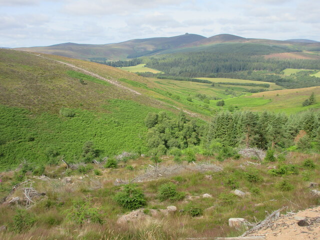
Hare Hill is a prominent hill located in Kincardineshire, Scotland. It is situated in a rural area, approximately 4 miles northeast of the town of Stonehaven. Standing at an elevation of 312 meters (1,023 feet), it offers stunning panoramic views of the surrounding countryside and coastline.

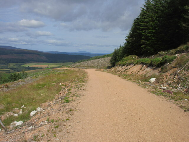
The hill is characterized by its gently sloping terrain, covered in a mix of grasses, heather, and scattered shrubs. It is a popular destination for outdoor enthusiasts, hikers, and nature lovers, who can enjoy its tranquil and picturesque setting. The well-maintained path leading to the summit makes it accessible to visitors of all fitness levels.

At the top of Hare Hill, there is a cairn, a man-made pile of stones, which serves as a marker and offers a point of interest for visitors. From this vantage point, on a clear day, one can enjoy breathtaking views of the North Sea, the nearby Dunnottar Castle, and the rolling hills of Aberdeenshire.

The hill is also home to a diverse range of wildlife, including various bird species, such as buzzards and kestrels, as well as rabbits and deer. It is not uncommon to spot wildflowers and butterflies during the summer months, adding to the natural beauty of the area.

Overall, Hare Hill is a magnificent natural landmark in Kincardineshire, offering a peaceful escape and a chance to immerse oneself in the stunning Scottish countryside. Whether for a leisurely walk or a more challenging hike, visitors are sure to be captivated by the beauty and tranquility of this picturesque hill.

If you have any feedback on the listing, please let us know in the comments section below.

Hare Hill Images

Images are sourced within 2km of 56.979955/-2.5396977 or Grid Reference NO6787. Thanks to Geograph Open Source API. All images are credited.

Top of Melmannoch, 385m I was here a month ago, but my camera ran out of battery then. Rocks were a good spot to sit and have a snack.
Top of Melmannoch, 385m
I was here a month ago, but my camera ran out of battery then. Rocks were a good spot to sit and have a snack.
View from the summit of Melmannoch, over the area called "Factors Rees", towards Kerloch Rees, buchts or fanks are something to do with sheep pens, but I didn't see any.
View from the summit of Melmannoch, over the area called "Factors Rees", towards Kerloch
Rees, buchts or fanks are something to do with sheep pens, but I didn't see any.
One of the upper arms of the Burn of Melmannoch
Moorland around the Burn of Melmannoch This is particularly foul moorland to cross; it appears to be unmanaged. so the heather is thigh high.
Moorland around the Burn of Melmannoch
This is particularly foul moorland to cross; it appears to be unmanaged. so the heather is thigh high.
Hilltop Lochan A small hillside lochan on Little Kerloch summit plateau.  Crystal clear water.  Kerloch summit in background
Hilltop Lochan
A small hillside lochan on Little Kerloch summit plateau. Crystal clear water. Kerloch summit in background
Overgrown ditch A ditch almost overgrown with heather marks a direct route to Melmannoch summit
Overgrown ditch
A ditch almost overgrown with heather marks a direct route to Melmannoch summit
Rocky Summit Rocky summit of Melmannoch 385m
Rocky Summit
Rocky summit of Melmannoch 385m
Forested southern side of Little Kerloch The forested southern slopes of Little Kerloch, viewed from the track across a cleared area.
Forested southern side of Little Kerloch
The forested southern slopes of Little Kerloch, viewed from the track across a cleared area.
Hillside across the Builg Burn Looking south-westwards across the valley of the Builg Burn to the opposite hillside.
Hillside across the Builg Burn
Looking south-westwards across the valley of the Builg Burn to the opposite hillside.
Track through cleared area of forest Forestry track heading north-westwards through a cleared area, with Morven in the far distance on the horizon.
Track through cleared area of forest
Forestry track heading north-westwards through a cleared area, with Morven in the far distance on the horizon.
Bracken covered hillside Looking westwards over the gully of the Builg Burn to the bracken infested lower northern slopes of Heathery Hill, with Clachnaben in the distance.
Bracken covered hillside
Looking westwards over the gully of the Builg Burn to the bracken infested lower northern slopes of Heathery Hill, with Clachnaben in the distance.
Forest track heading north Forestry track heading downhill to the north, with the Craig of Dalfro ahead.
Forest track heading north
Forestry track heading downhill to the north, with the Craig of Dalfro ahead.
Cleared area of forest Looking down a felled area of forest in a south-westerly direction, with Clachnaben in the distance.
Cleared area of forest
Looking down a felled area of forest in a south-westerly direction, with Clachnaben in the distance.
Ride, Heathery Hill Heathery Hill is not as heathery now as it is nearly all under conifers.
Ride, Heathery Hill
Heathery Hill is not as heathery now as it is nearly all under conifers.
Road, Heathery Hill A gravel forest road, shown as a dead end on the map - I went no further as I had the delights of a wind farm to look forward to. Headed back to the through road on Tire Beggar to the south.
Road, Heathery Hill
A gravel forest road, shown as a dead end on the map - I went no further as I had the delights of a wind farm to look forward to. Headed back to the through road on Tire Beggar to the south.
Foot Bridge over Water of Dye 2.3 km south of Bogendreip
Foot Bridge over Water of Dye
2.3 km south of Bogendreip
Heathery Hill From the track on the hill looking across to the Bridge of Dye
and on to Clachnaben and Mount Shade
Heathery Hill
From the track on the hill looking across to the Bridge of Dye and on to Clachnaben and Mount Shade
Near Scolly's Cross above the Water of Dye This small area of rough grazing is surrounded by cultivated land and woods.
Near Scolly's Cross above the Water of Dye
This small area of rough grazing is surrounded by cultivated land and woods.
Show me another place!

Hare Hill is located at Grid Ref: NO6787 (Lat: 56.979955, Lng: -2.5396977)

Unitary Authority: Aberdeenshire

Police Authority: North East

What 3 Words

///clubbing.currently.chainsaw. Near Banchory, Aberdeenshire

Nearby Locations

Hare Hill

Related Wikis

Strachan, Aberdeenshire

Strachan is a village in Aberdeenshire, Scotland that lies along the Water of Feugh, a tributary of the River Dee, Aberdeenshire, a few miles southwest...

Water of Aven

The Water of Aven (or A'an) (Scottish Gaelic: an t-Uisge Bàn) is a tributary of the Water of Feugh, itself the largest tributary of the River Dee, Aberdeenshire...

Clachnaben

Clachnaben (archaically "Cloch-na'bain"; Scottish Gaelic: "Clach na Beinne") is a 589-metre hill in Glen Dye, Aberdeenshire, Scotland. It is a distinctive...

Scolty Hill

Scolty Hill is a small hill south of the Deeside town, Banchory. Its best known feature is the 20m tall tower monument, built in 1840 as a memorial to...

Nearby Amenities

Located within 500m of 56.979955,-2.5396977
Deil's Oxter
Natural: valley
Lat/Long: 56.9820482/-2.5402712
The data included in this document is from www.openstreetmap.org. The data is made available under ODbL.

Have you been to Hare Hill?

Leave your review of Hare Hill below (or comments, questions and feedback).