Carlin Tooth

Hill, Mountain in Roxburghshire

Scotland

Carlin Tooth

The Scotland/England border from the air Approximately Scotland to the left of centre, England to the right.
The Scotland/England border from the air Credit: Thomas Nugent

Carlin Tooth, located in Roxburghshire, Scotland, is a prominent hill that forms part of the Moorfoot Hills range. With an elevation of 552 meters (1,811 feet), it offers stunning panoramic views of the surrounding countryside.

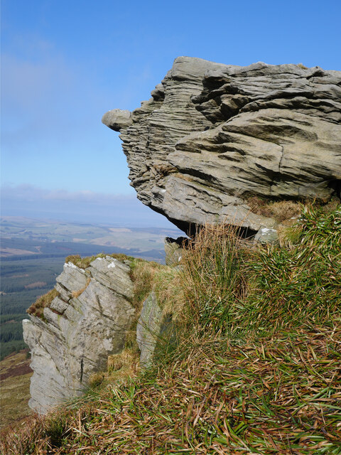
Covered in heather and grass, Carlin Tooth boasts a rugged and wild beauty that attracts outdoor enthusiasts, hikers, and nature lovers alike. The hill's distinct shape, resembling a pointed tooth, adds to its allure and makes it a prominent landmark in the area.

Carlin Tooth is easily accessible from the nearby village of Heriot, which lies approximately 7 kilometers (4 miles) to the north. A well-defined path leads up the hill, ensuring a relatively straightforward ascent for those wishing to reach its summit. However, as with any hill or mountain, caution should be exercised, and appropriate clothing and footwear are recommended.

From the summit of Carlin Tooth, visitors are rewarded with breathtaking views across Roxburghshire and the surrounding Scottish Borders region. On a clear day, it is possible to see as far as the Lammermuir Hills to the east and the Pentland Hills to the north. The hill also offers an opportunity to observe local wildlife, including birds of prey such as buzzards and kestrels.

Carlin Tooth, with its natural beauty and captivating views, provides an ideal destination for those seeking a peaceful and invigorating outdoor experience in Roxburghshire.

If you have any feedback on the listing, please let us know in the comments section below.

Carlin Tooth Images

Images are sourced within 2km of 55.314763/-2.5830974 or Grid Reference NT6302. Thanks to Geograph Open Source API. All images are credited.

The Scotland/England border from the air Approximately Scotland to the left of centre, England to the right.
The Scotland/England border from the air
Approximately Scotland to the left of centre, England to the right.
The Scotland/England border from the air Approximately Scotland to the left of centre, England to the right.
The Scotland/England border from the air
Approximately Scotland to the left of centre, England to the right.
Bound for Hartshorn Pike A glorious day across the Scottish Borders with wall-to-wall sunshine and yet the ascent of Hartshorn Pike from Wheelrig Head is in the gloom!  Eventually this cloud did lift, but for the meantime it made for atmospheric walking in this firebreak in the Wauchope Forest.

This photograph was taken during the Coronavirus (COVID-19) pandemic of 2020/21.
Bound for Hartshorn Pike
A glorious day across the Scottish Borders with wall-to-wall sunshine and yet the ascent of Hartshorn Pike from Wheelrig Head is in the gloom! Eventually this cloud did lift, but for the meantime it made for atmospheric walking in this firebreak in the Wauchope Forest. This photograph was taken during the Coronavirus (COVID-19) pandemic of 2020/21.
Rock formations at Carlin Tooth Grey sandstone rock formations at Carlin Tooth overlooking the Wauchope Forest.  

This photograph was taken during the Coronavirus (COVID-19) pandemic of 2020/21.
Rock formations at Carlin Tooth
Grey sandstone rock formations at Carlin Tooth overlooking the Wauchope Forest. This photograph was taken during the Coronavirus (COVID-19) pandemic of 2020/21.
A hag at Carlin Tooth? 'Carlin' is a very old Scots language disparaging term for a woman, hag or witch (see <span class="nowrap"><a title="https://www.scotslanguage.com/articles/view/id/5102" rel="nofollow ugc noopener" href="https://www.scotslanguage.com/articles/view/id/5102">Link</a><img style="margin-left:2px;" alt="External link" title="External link - shift click to open in new window" src="https://s1.geograph.org.uk/img/external.png" width="10" height="10"/></span> ) - is this applicable to this weathered sandstone outcrop?

This photograph was taken during the Coronavirus (COVID-19) pandemic of 2020/21.
A hag at Carlin Tooth?
'Carlin' is a very old Scots language disparaging term for a woman, hag or witch (see LinkExternal link ) - is this applicable to this weathered sandstone outcrop? This photograph was taken during the Coronavirus (COVID-19) pandemic of 2020/21.
The cloud lifts at the summit of Carlin Tooth The entire walk from Note o' the Gate on the B6357 via Wheelrig Head and Hartshorn Pike had been cloaked in thick hill cloud.  After nearly and hour at the summit, the cloud began to dissipate and warm sunshine made an appearance.  The view here is at the summit triangulation pillar and wind shelter - an ideal lunch spot.

This photograph was taken during the Coronavirus (COVID-19) pandemic of 2020/21.
The cloud lifts at the summit of Carlin Tooth
The entire walk from Note o' the Gate on the B6357 via Wheelrig Head and Hartshorn Pike had been cloaked in thick hill cloud. After nearly and hour at the summit, the cloud began to dissipate and warm sunshine made an appearance. The view here is at the summit triangulation pillar and wind shelter - an ideal lunch spot. This photograph was taken during the Coronavirus (COVID-19) pandemic of 2020/21.
Snow in a shake hole This deep shake hole still harbours a small remnant of the recent heavy snows.  

This photograph was taken during the Coronavirus (COVID-19) pandemic of 2020/21.
Snow in a shake hole
This deep shake hole still harbours a small remnant of the recent heavy snows. This photograph was taken during the Coronavirus (COVID-19) pandemic of 2020/21.
Across dense heather moorland to the valley of the Green Needle Standing in an area of shake holes combined with straggly heather and peat banks does not make for pleasant walking.  Nevertheless, the view down to the valley of the Green Needle makes the effort worthwhile.

This photograph was taken during the Coronavirus (COVID-19) pandemic of 2020/21.
Across dense heather moorland to the valley of the Green Needle
Standing in an area of shake holes combined with straggly heather and peat banks does not make for pleasant walking. Nevertheless, the view down to the valley of the Green Needle makes the effort worthwhile. This photograph was taken during the Coronavirus (COVID-19) pandemic of 2020/21.
The Wauchope Forest from Carlin Tooth A self-seeded Sitka Spruce is in the foreground whilst the Wauchope Forest sprawls below.

This photograph was taken during the Coronavirus (COVID-19) pandemic of 2020/21.
The Wauchope Forest from Carlin Tooth
A self-seeded Sitka Spruce is in the foreground whilst the Wauchope Forest sprawls below. This photograph was taken during the Coronavirus (COVID-19) pandemic of 2020/21.
Moorland pool on Hartshorn Pike A moorland pool near the summit of Hartshorn Pike.  Already, life was to be seen in these acidic waters in the form of several Whirligig Beetles.  The 'path' to Carlin Tooth follows the old fence line which can be noted to the far right of shot in the background.

This photograph was taken during the Coronavirus (COVID-19) pandemic of 2020/21.
Moorland pool on Hartshorn Pike
A moorland pool near the summit of Hartshorn Pike. Already, life was to be seen in these acidic waters in the form of several Whirligig Beetles. The 'path' to Carlin Tooth follows the old fence line which can be noted to the far right of shot in the background. This photograph was taken during the Coronavirus (COVID-19) pandemic of 2020/21.
Heading down from Hartshorn Pike A final coffee break before heading down from the summit area of Hartshorn Pike to enter the Wauchope Forest once more.  A distant Ruberslaw can be noted in this shot.  To the south, out of shot, the distant Solway Firth could be noted reflecting the low afternoon sunshine.

This photograph was taken during the Coronavirus (COVID-19) pandemic of 2020/21.
Heading down from Hartshorn Pike
A final coffee break before heading down from the summit area of Hartshorn Pike to enter the Wauchope Forest once more. A distant Ruberslaw can be noted in this shot. To the south, out of shot, the distant Solway Firth could be noted reflecting the low afternoon sunshine. This photograph was taken during the Coronavirus (COVID-19) pandemic of 2020/21.
Hawker Hurricane crash site on Peel Fell A view of the impact crater and aircraft remains from the crash of a Hawker Hurricane on 3 November 1941.  A small plaque mounted on wood commemorating P/O Hukum Chand Mehta who was killed in the crash overlooks the site.  As always when visiting such sites, treat them with respect.  

For further information, see <span class="nowrap"><a title="https://acia.co.uk/1941/11/03/hurricane-z3150/" rel="nofollow ugc noopener" href="https://acia.co.uk/1941/11/03/hurricane-z3150/">Link</a><img style="margin-left:2px;" alt="External link" title="External link - shift click to open in new window" src="https://s1.geograph.org.uk/img/external.png" width="10" height="10"/></span> , <span class="nowrap"><a title="https://northeastatwar.co.uk/2019/02/02/hurricane-z3150-deadwater/" rel="nofollow ugc noopener" href="https://northeastatwar.co.uk/2019/02/02/hurricane-z3150-deadwater/">Link</a><img style="margin-left:2px;" alt="External link" title="External link - shift click to open in new window" src="https://s1.geograph.org.uk/img/external.png" width="10" height="10"/></span> and <span class="nowrap"><a title="http://bharat-rakshak.com/IAF/history/ww2/veterans/1038-hcmehta.html#gsc.tab=0" rel="nofollow ugc noopener" href="http://bharat-rakshak.com/IAF/history/ww2/veterans/1038-hcmehta.html#gsc.tab=0">Link</a><img style="margin-left:2px;" alt="External link" title="External link - shift click to open in new window" src="https://s1.geograph.org.uk/img/external.png" width="10" height="10"/></span>

This photograph was taken during the Coronavirus (COVID-19) pandemic of 2020/21.
Hawker Hurricane crash site on Peel Fell
A view of the impact crater and aircraft remains from the crash of a Hawker Hurricane on 3 November 1941. A small plaque mounted on wood commemorating P/O Hukum Chand Mehta who was killed in the crash overlooks the site. As always when visiting such sites, treat them with respect. For further information, see LinkExternal link , LinkExternal link and LinkExternal link This photograph was taken during the Coronavirus (COVID-19) pandemic of 2020/21.
Propeller hub on Peel Fell The Hawker Hurricane propeller hub at the crash site of Z3150 on Peel Fell, 3 November 1941.  A small plaque mounted on wood commemorating P/O Hukum Chand Mehta who was killed in the crash overlooks the site.  As always when visiting such sites, treat them with respect.  

For further information, see <span class="nowrap"><a title="https://acia.co.uk/1941/11/03/hurricane-z3150/" rel="nofollow ugc noopener" href="https://acia.co.uk/1941/11/03/hurricane-z3150/">Link</a><img style="margin-left:2px;" alt="External link" title="External link - shift click to open in new window" src="https://s1.geograph.org.uk/img/external.png" width="10" height="10"/></span> , <span class="nowrap"><a title="https://northeastatwar.co.uk/2019/02/02/hurricane-z3150-deadwater/" rel="nofollow ugc noopener" href="https://northeastatwar.co.uk/2019/02/02/hurricane-z3150-deadwater/">Link</a><img style="margin-left:2px;" alt="External link" title="External link - shift click to open in new window" src="https://s1.geograph.org.uk/img/external.png" width="10" height="10"/></span> and <span class="nowrap"><a title="http://bharat-rakshak.com/IAF/history/ww2/veterans/1038-hcmehta.html#gsc.tab=0" rel="nofollow ugc noopener" href="http://bharat-rakshak.com/IAF/history/ww2/veterans/1038-hcmehta.html#gsc.tab=0">Link</a><img style="margin-left:2px;" alt="External link" title="External link - shift click to open in new window" src="https://s1.geograph.org.uk/img/external.png" width="10" height="10"/></span>

This photograph was taken during the Coronavirus (COVID-19) pandemic of 2020/21.
Propeller hub on Peel Fell
The Hawker Hurricane propeller hub at the crash site of Z3150 on Peel Fell, 3 November 1941. A small plaque mounted on wood commemorating P/O Hukum Chand Mehta who was killed in the crash overlooks the site. As always when visiting such sites, treat them with respect. For further information, see LinkExternal link , LinkExternal link and LinkExternal link This photograph was taken during the Coronavirus (COVID-19) pandemic of 2020/21.
Old Boundary Marker on Duntae Edge Estate Boundary Marker on Duntae Edge, 580 metres northwest of Knox Knowe. On the boundary of Plashetts and Tynehead chapelry in Falstone parish, from 1811 Plashetts and Tynehead parish, from 1955 Kielder parish in Northumberland, and Southdean parish in Roxburghshire. Marking the boundary of lands owned by the Duke of Northumberland and the Douglas family. See also <a title="https://www.geograph.org.uk/photo/4111205" href="https://www.geograph.org.uk/photo/4111205">Link</a>.

Milestone Society National ID: NB_KIESDE01em
Old Boundary Marker on Duntae Edge
Estate Boundary Marker on Duntae Edge, 580 metres northwest of Knox Knowe. On the boundary of Plashetts and Tynehead chapelry in Falstone parish, from 1811 Plashetts and Tynehead parish, from 1955 Kielder parish in Northumberland, and Southdean parish in Roxburghshire. Marking the boundary of lands owned by the Duke of Northumberland and the Douglas family. See also Link. Milestone Society National ID: NB_KIESDE01em
Old Boundary Marker on Duntae Edge Estate Boundary Marker on Duntae Edge, 490 metres northwest of Knox Knowe. On the boundary of Plashetts and Tynehead chapelry in Falstone parish, from 1811 Plashetts and Tynehead parish, from 1955 Kielder parish in Northumberland, and Southdean parish in Roxburghshire. Inscribed N on the south face and D in reverse on the north face. Marking the boundary of lands owned by the Duke of Northumberland and the Douglas family.

Milestone Society National ID: NB_KIESDE02em
Old Boundary Marker on Duntae Edge
Estate Boundary Marker on Duntae Edge, 490 metres northwest of Knox Knowe. On the boundary of Plashetts and Tynehead chapelry in Falstone parish, from 1811 Plashetts and Tynehead parish, from 1955 Kielder parish in Northumberland, and Southdean parish in Roxburghshire. Inscribed N on the south face and D in reverse on the north face. Marking the boundary of lands owned by the Duke of Northumberland and the Douglas family. Milestone Society National ID: NB_KIESDE02em
Upper reaches of Wauchope Forest Beneath Scrathy Holes near the edge of the deep heather moors on the hills above Kielder. Taken from the road where walkers need to be competent with tying shoelaces and be aware that the mapped tracks can at times differ from reality.  (A 1:50,000 is more than adequate, especially on the hill above).
Upper reaches of Wauchope Forest
Beneath Scrathy Holes near the edge of the deep heather moors on the hills above Kielder. Taken from the road where walkers need to be competent with tying shoelaces and be aware that the mapped tracks can at times differ from reality. (A 1:50,000 is more than adequate, especially on the hill above).
Logging road, Wauchope Forest Passing Inner Cleuch, which like many cleuchs in Wauchope Forest is rather undramatic.
Logging road, Wauchope Forest
Passing Inner Cleuch, which like many cleuchs in Wauchope Forest is rather undramatic.
Logging, Wauchope Forest Sunday, and everything parked up - this is always a good day to visit a commercial forest as encountering felling is almost inevitable on a week day. These trees: <a href="https://www.geograph.org.uk/photo/530448">NT6203 : Forestry at Ravenburn</a> are being cut down near Ravenburn.
Logging, Wauchope Forest
Sunday, and everything parked up - this is always a good day to visit a commercial forest as encountering felling is almost inevitable on a week day. These trees: NT6203 : Forestry at Ravenburn are being cut down near Ravenburn.
Show me another place!

Carlin Tooth is located at Grid Ref: NT6302 (Lat: 55.314763, Lng: -2.5830974)

Unitary Authority: The Scottish Borders

Police Authority: The Lothians and Scottish Borders

What 3 Words

///undivided.inferior.general. Near Hawick, Scottish Borders

Nearby Locations

Carlin Tooth

Related Wikis

Wauchope Forest

Wauchope Forest is a forest on the Rule Water, in the Scottish Borders area of Scotland, south of Hawick, and including the A6088, the A68 and the B6357...

Deadwater railway station

Deadwater railway station is a closed railway station situated on the border between England and Scotland at the head of the North Tyne River. The station...

Deadwater, Northumberland

Deadwater is a small settlement in Northumberland, England, about 3 miles (5 km) north west of Kielder, Northumberland, on the English side of the border...

Southdean

Southdean is a hamlet in the Scottish Borders area of Scotland, on the A6088, by the Jed Water and in the Wauchope Forest area. Other settlements nearby...

Nearby Amenities

Located within 500m of 55.314763,-2.5830974
Carlin Tooth
Ele: 549
Natural: peak
Lat/Long: 55.3142357/-2.5833414
The data included in this document is from www.openstreetmap.org. The data is made available under ODbL.

Have you been to Carlin Tooth?

Leave your review of Carlin Tooth below (or comments, questions and feedback).