Balnacraig Hill

Hill, Mountain in Aberdeenshire

Scotland

Balnacraig Hill

The Macbeth Stone in Lumphanan The Battle of Lumphanan was fought on 15 August 1057, between Macbeth, King of Scots, and the future King Malcolm III. Macbeth would die from wounds sustained in the battle, which came after his defeat at the battle of Dunsinane in 1054. According to tradition, the battle took place at Lumphanan in Aberdeenshire. Macbeth's Stone, a large boulder at the site, is said to mark the spot where Macbeth was mortally wounded. Following the battle Lulach, Macbeth's stepson was crowned King, before being killed by Malcolm who then took the throne.
The Macbeth Stone in Lumphanan Credit: Ralph Greig

Balnacraig Hill is a prominent landmark located in Aberdeenshire, Scotland. Standing at an elevation of 562 meters (1,844 feet), it is classified as a hill rather than a mountain. Its geographical coordinates are 57.061°N latitude and 2.434°W longitude.

The hill is located approximately 6 kilometers (3.7 miles) northeast of the town of Banchory and is easily accessible via a network of trails and paths. It is a popular destination for hikers, nature enthusiasts, and outdoor adventurers due to its stunning panoramic views of the surrounding countryside.

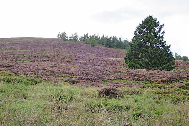
Balnacraig Hill is characterized by its gently sloping sides and heather-covered terrain. The hill is mostly composed of granite, a common feature in the Aberdeenshire region, which gives it a rugged and distinctive appearance.

The area around Balnacraig Hill is rich in biodiversity, with a variety of flora and fauna. It is home to several species of birds, including grouse and pheasants, as well as mammals such as deer and rabbits. The hill's diverse plant life includes heather, bracken, and various wildflowers.

The summit of Balnacraig Hill offers breathtaking views of the surrounding landscape, including the nearby River Dee and the rolling hills of Aberdeenshire. On a clear day, it is possible to see as far as the Cairngorms National Park to the west.

Overall, Balnacraig Hill is a picturesque and accessible destination for outdoor enthusiasts, offering both natural beauty and recreational opportunities.

If you have any feedback on the listing, please let us know in the comments section below.

Balnacraig Hill Images

Images are sourced within 2km of 57.131802/-2.6578257 or Grid Reference NJ6004. Thanks to Geograph Open Source API. All images are credited.

The Macbeth Stone in Lumphanan The Battle of Lumphanan was fought on 15 August 1057, between Macbeth, King of Scots, and the future King Malcolm III. Macbeth would die from wounds sustained in the battle, which came after his defeat at the battle of Dunsinane in 1054. According to tradition, the battle took place at Lumphanan in Aberdeenshire. Macbeth's Stone, a large boulder at the site, is said to mark the spot where Macbeth was mortally wounded. Following the battle Lulach, Macbeth's stepson was crowned King, before being killed by Malcolm who then took the throne.
The Macbeth Stone in Lumphanan
The Battle of Lumphanan was fought on 15 August 1057, between Macbeth, King of Scots, and the future King Malcolm III. Macbeth would die from wounds sustained in the battle, which came after his defeat at the battle of Dunsinane in 1054. According to tradition, the battle took place at Lumphanan in Aberdeenshire. Macbeth's Stone, a large boulder at the site, is said to mark the spot where Macbeth was mortally wounded. Following the battle Lulach, Macbeth's stepson was crowned King, before being killed by Malcolm who then took the throne.
Macbeth Arms hotel
Macbeth Arms hotel
A round circuit walk from Lumphanan Geocaching is a type of global treasure hunt of people looking for caches, or hidden stashes of objects. Geocaching may also be described as a series of hide-and-seek games, where hiders provide online clues for seekers. Seekers use global positioning system (GPS) devices to find hidden caches
A round circuit walk from Lumphanan
Geocaching is a type of global treasure hunt of people looking for caches, or hidden stashes of objects. Geocaching may also be described as a series of hide-and-seek games, where hiders provide online clues for seekers. Seekers use global positioning system (GPS) devices to find hidden caches
Glenshalg croft Geocaching is a type of global treasure hunt of people looking for caches, or hidden stashes of objects. Geocaching may also be described as a series of hide-and-seek games, where hiders provide online clues for seekers. Seekers use global positioning system (GPS) devices to find hidden caches
Glenshalg croft
Geocaching is a type of global treasure hunt of people looking for caches, or hidden stashes of objects. Geocaching may also be described as a series of hide-and-seek games, where hiders provide online clues for seekers. Seekers use global positioning system (GPS) devices to find hidden caches
A980 in Lumphanan
A980 in Lumphanan
A980 near Lumphanan
A980 near Lumphanan
Recently harvested timber near Tornaveen
A980 towards Torphins
Macbeth Arms Hotel Originally this was the Station Hotel, built in 1860 to a design by John Stuart of Muchalls. The  railway reached Lumphanan in 1859, resulting in the growth of a new village here beside the station. At some point its name has been changed to commemorate the death of Macbeth nearby in 1057 AD.
Macbeth Arms Hotel
Originally this was the Station Hotel, built in 1860 to a design by John Stuart of Muchalls. The railway reached Lumphanan in 1859, resulting in the growth of a new village here beside the station. At some point its name has been changed to commemorate the death of Macbeth nearby in 1057 AD.
Post Office Like the hotel next door, the Post Office was designed by John Stuart of Muchalls and built in 1860, with an arcaded front at ground level. Rather remarkably in this day and age, the building still houses a post office.
Post Office
Like the hotel next door, the Post Office was designed by John Stuart of Muchalls and built in 1860, with an arcaded front at ground level. Rather remarkably in this day and age, the building still houses a post office.
Aberdeen Town and Country Bank Now a private house, this building with Doric portico was designed by William Smith and dates from 1867.
Aberdeen Town and Country Bank
Now a private house, this building with Doric portico was designed by William Smith and dates from 1867.
Tom Tough's Well The well was erected in 1880, one of many drinking fountains provided in Victorian times for the benefit of thirsty travellers, but even the Royal Commission on the Ancient and Historical Monuments of Scotland, while noting its existence, is silent on the subject of Tom Tough himself. See <span class="nowrap"><a title="https://canmore.org.uk/site/147829/glenmillan-house-tom-toughs-well" rel="nofollow ugc noopener" href="https://canmore.org.uk/site/147829/glenmillan-house-tom-toughs-well">Link</a><img style="margin-left:2px;" alt="External link" title="External link - shift click to open in new window" src="https://s1.geograph.org.uk/img/external.png" width="10" height="10"/></span> for details.
 
The census records Thomas Tough and his wife Dorothy or Dorothea living at Glenmillan in 1841 and 1851. In 1841 Thomas is described as a blacksmith, but in 1851 he is a former veterinary surgeon, aged 78. So it is probably after him that the well is named. 

Naturally the well no longer provides water, having no doubt fallen victim to health and safety legislation like all its fellows.
Tom Tough's Well
The well was erected in 1880, one of many drinking fountains provided in Victorian times for the benefit of thirsty travellers, but even the Royal Commission on the Ancient and Historical Monuments of Scotland, while noting its existence, is silent on the subject of Tom Tough himself. See LinkExternal link for details. The census records Thomas Tough and his wife Dorothy or Dorothea living at Glenmillan in 1841 and 1851. In 1841 Thomas is described as a blacksmith, but in 1851 he is a former veterinary surgeon, aged 78. So it is probably after him that the well is named. Naturally the well no longer provides water, having no doubt fallen victim to health and safety legislation like all its fellows.
Plaque on Tom Tough's Well This is the polished granite plaque on <a href="https://www.geograph.org.uk/photo/5533385">NJ5905 : Tom Tough's Well</a>. I have yet to discover who RMS might have been.
Plaque on Tom Tough's Well
This is the polished granite plaque on NJ5905 : Tom Tough's Well. I have yet to discover who RMS might have been.
Disappearing Seat It would have been easy to overlook this iron bench, presumably provided for weary travellers to sit on while they enjoy a drink from <a href="https://www.geograph.org.uk/photo/5533385">NJ5905 : Tom Tough's Well</a> just across the road. It can't be for the view, because the maps show that it was always surrounded by trees.
Disappearing Seat
It would have been easy to overlook this iron bench, presumably provided for weary travellers to sit on while they enjoy a drink from NJ5905 : Tom Tough's Well just across the road. It can't be for the view, because the maps show that it was always surrounded by trees.
Plaque on a Bench This is on the top of <a href="https://www.geograph.org.uk/photo/5533396">NJ5905 : Disappearing Seat</a>. A Robert Clifford Moir was born in Lumphanan in 1907, son of Robert Stuart Moir who was born there in 1883. Both died in Aberdeen, father in 1958 and son in 1974.
Plaque on a Bench
This is on the top of NJ5905 : Disappearing Seat. A Robert Clifford Moir was born in Lumphanan in 1907, son of Robert Stuart Moir who was born there in 1883. Both died in Aberdeen, father in 1958 and son in 1974.
Cloak Wood A heathery slope below part of Cloak Wood on the summit of Glenshalg Hill.
Cloak Wood
A heathery slope below part of Cloak Wood on the summit of Glenshalg Hill.
Near Maryfield Rough grazing in the dip south of Glenshalg Hill.
Near Maryfield
Rough grazing in the dip south of Glenshalg Hill.
The B9119 heading for Tarland
Show me another place!

Balnacraig Hill is located at Grid Ref: NJ6004 (Lat: 57.131802, Lng: -2.6578257)

Unitary Authority: Aberdeenshire

Police Authority: North East

What 3 Words

///cross.ruffling.starting. Near Torphins, Aberdeenshire

Nearby Locations

Balnacraig Hill

Related Wikis

Nearby Amenities

Located within 500m of 57.131802,-2.6578257
Balnacraig Hill
Ele: 284
Natural: peak
Lat/Long: 57.1319569/-2.6578515
Operator: SSE
Power: pole
Lat/Long: 57.1345909/-2.6515343
Material: wood
Operator: SSE
Power: pole
Lat/Long: 57.1335521/-2.6595708
Operator: SSE
Power: pole
Lat/Long: 57.1345755/-2.6524841
Material: wood
Operator: SSE
Power: pole
Lat/Long: 57.132982/-2.6599211
Operator: SSE
Power: pole
Lat/Long: 57.1345759/-2.6536301
Material: wood
Operator: SSE
Power: pole
Lat/Long: 57.1323521/-2.6603391
Operator: SSE
Power: pole
Lat/Long: 57.1344855/-2.654489
Material: wood
Operator: SSE
Power: pole
Lat/Long: 57.1317568/-2.6607007
Operator: SSE
Power: pole
Lat/Long: 57.1343752/-2.6555013
Material: wood
Operator: SSE
Power: pole
Lat/Long: 57.1311796/-2.6610662
Operator: SSE
Power: pole
Lat/Long: 57.1342682/-2.6565185
Material: wood
Operator: SSE
Power: pole
Lat/Long: 57.1299508/-2.6618515
Operator: SSE
Power: pole
Lat/Long: 57.1339821/-2.6592877
Material: wood
Operator: SSE
Power: pole
Lat/Long: 57.129441/-2.662414
Operator: SSE
Power: pole
Lat/Long: 57.1305629/-2.6613983
Material: wood
Operator: SSE
Power: pole
Lat/Long: 57.1289168/-2.6629954
Operator: SSE
Power: pole
Lat/Long: 57.1340628/-2.658473
Operator: SSE
Power: pole
Lat/Long: 57.1341702/-2.6574541
The data included in this document is from www.openstreetmap.org. The data is made available under ODbL.

Have you been to Balnacraig Hill?

Leave your review of Balnacraig Hill below (or comments, questions and feedback).