Innox Hill

Settlement in Somerset Mendip

England

Innox Hill

Old Milestone Plate, Frome Museum The plate was originally attached to the milestone that was located on Marston Road, Frome, at the roundabout junction with the A381 (ST 77817 48242). Old Bruton iron plate design, milestone erected by the Bruton turnpike trust in the 19th century.

Inscription reads:-
TO
BRUTON
9

Milestone Society National ID: SO_BNFR09
Old Milestone Plate, Frome Museum Credit: Janet Dowding

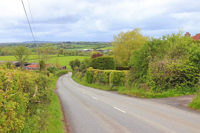
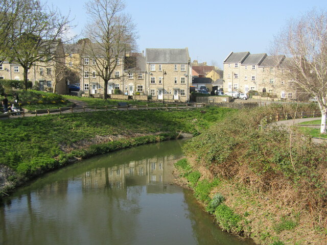
Innox Hill is a charming village located in Somerset, England. Situated on a gentle slope, it offers breathtaking panoramic views of the surrounding countryside. The village is nestled amidst lush green fields and rolling hills, giving it a serene and tranquil atmosphere.

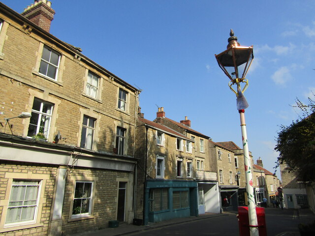
The architecture of Innox Hill is predominantly Georgian, with many well-preserved buildings dating back to the 18th and 19th centuries. The village is renowned for its picturesque cottages, which boast beautiful thatched roofs and colorful gardens. These traditional houses add to the village's quaint and idyllic charm.

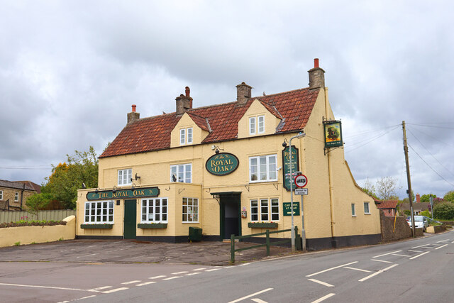
Despite its small size, Innox Hill is well-equipped with amenities and services for residents and visitors. The village has a local grocery store, a post office, and a cozy pub, where locals gather to socialize and enjoy a pint. The community spirit is strong in Innox Hill, with regular events and festivals organized throughout the year, such as the annual summer fete and Christmas market.

Nature lovers will delight in the proximity of Innox Hill to the stunning Mendip Hills, a designated Area of Outstanding Natural Beauty. This makes the village a perfect base for exploring the surrounding countryside, whether through leisurely walks or more challenging hikes. Additionally, the nearby Cheddar Gorge, famous for its dramatic limestone cliffs and underground caves, offers a unique and awe-inspiring experience for visitors.

Innox Hill truly embodies the charm of rural England, with its picturesque landscapes, welcoming community, and rich history. It is a place where residents and visitors alike can escape the hustle and bustle of modern life and immerse themselves in the beauty and tranquility of the countryside.

If you have any feedback on the listing, please let us know in the comments section below.

Innox Hill Images

Images are sourced within 2km of 51.238512/-2.321987 or Grid Reference ST7748. Thanks to Geograph Open Source API. All images are credited.

Old Milestone Plate, Frome Museum The plate was originally attached to the milestone that was located on Marston Road, Frome, at the roundabout junction with the A381 (ST 77817 48242). Old Bruton iron plate design, milestone erected by the Bruton turnpike trust in the 19th century.

Inscription reads:-
TO
BRUTON
9

Milestone Society National ID: SO_BNFR09
Old Milestone Plate, Frome Museum
The plate was originally attached to the milestone that was located on Marston Road, Frome, at the roundabout junction with the A381 (ST 77817 48242). Old Bruton iron plate design, milestone erected by the Bruton turnpike trust in the 19th century. Inscription reads:- TO BRUTON 9 Milestone Society National ID: SO_BNFR09
Old Milestone Plate, Frome Museum The milestone to which the metal plate was originally attached could have been located at <a href="https://www.geograph.org.uk/gridref/ST647598">ST647598</a> on the A390 or at <a href="https://www.geograph.org.uk/gridref/ST6805854506">ST6805854506</a> on the A367. Old Bruton iron plate design, milestone erected by the Bruton turnpike trust in the 19th century. 

Inscription reads:- 
TO / BATH / 9 

Milestone Society National ID: SO_BA09
Old Milestone Plate, Frome Museum
The milestone to which the metal plate was originally attached could have been located at ST647598 on the A390 or at ST6805854506 on the A367. Old Bruton iron plate design, milestone erected by the Bruton turnpike trust in the 19th century. Inscription reads:- TO / BATH / 9 Milestone Society National ID: SO_BA09
Old Milestone, B3090, Fromefield, Frome The milestone is located opposite Brunswick Place, set into a stone wall on the west side of the road. Parish of Frome (Mendip District). Cast iron post, C&M Classical iron casting design, erected by the Black Dog turnpike trust in the 19th century. 

Inscription reads:-
BATH / 13 / FROME / MARKET HOUSE / ½ MILE / FROME

Grade II Listed, List Entry Number: 1296373
<span class="nowrap"><a title="https://historicengland.org.uk/listing/the-list/list-entry/1296373" rel="nofollow ugc noopener" href="https://historicengland.org.uk/listing/the-list/list-entry/1296373">Link</a><img style="margin-left:2px;" alt="External link" title="External link - shift click to open in new window" src="https://s1.geograph.org.uk/img/external.png" width="10" height="10"/></span>

Milestone Society National ID: SO_BAFR13
Old Milestone, B3090, Fromefield, Frome
The milestone is located opposite Brunswick Place, set into a stone wall on the west side of the road. Parish of Frome (Mendip District). Cast iron post, C&M Classical iron casting design, erected by the Black Dog turnpike trust in the 19th century. Inscription reads:- BATH / 13 / FROME / MARKET HOUSE / ½ MILE / FROME Grade II Listed, List Entry Number: 1296373 LinkExternal link Milestone Society National ID: SO_BAFR13
The Blue Boar Public House in Frome.
The Blue Boar
Public House in Frome.
The Royal Oak Public House in Frome.
The Royal Oak
Public House in Frome.
Egford Hill Downhill towards Frome.
Egford Hill
Downhill towards Frome.
Frome Flea Market at the Cheese and Grain Takes place on Wednesdays, 9 am till 2 pm.
Frome Flea Market at the Cheese and Grain
Takes place on Wednesdays, 9 am till 2 pm.
Frome - The Blue House Historic building, former almshouses, then a Bluecoat School, now retirement flats.
Frome - The Blue House
Historic building, former almshouses, then a Bluecoat School, now retirement flats.
Frome - River Frome View from the bridge towards modern housing overlooking the river.
Frome - River Frome
View from the bridge towards modern housing overlooking the river.
Frome - George Hotel Old hostelry and the Market Cross in central Frome.
Frome - George Hotel
Old hostelry and the Market Cross in central Frome.
Frome - Parish Church St John the Baptist, an historic and venerable church in central Frome.
Frome - Parish Church
St John the Baptist, an historic and venerable church in central Frome.
Frome - Font 13th century font within St John the Baptist Church. Note also the historic font cover.
Frome - Font
13th century font within St John the Baptist Church. Note also the historic font cover.
Frome - St John the Baptist Church High cross - an interior view within Frome's historic parish church.
Frome - St John the Baptist Church
High cross - an interior view within Frome's historic parish church.
Frome - Bath Street Main street in central Frome, heading downhill from the parish church towards the Market Place.
Frome - Bath Street
Main street in central Frome, heading downhill from the parish church towards the Market Place.
Frome - Palmer Street Historic lane with many independent shops in central Frome.
Frome - Palmer Street
Historic lane with many independent shops in central Frome.
Frome - Catherine Street Historic narrow town centre street with many old stone buildings.
Frome - Catherine Street
Historic narrow town centre street with many old stone buildings.
Frome - Catherine by Gaslight Catherine Street and historic gas lamp (The Valentine Lamp) in central Frome.
Frome - Catherine by Gaslight
Catherine Street and historic gas lamp (The Valentine Lamp) in central Frome.
Frome - The Valentine Lamp Historic gas lamp on Catherine Street - note the small heart.
Frome - The Valentine Lamp
Historic gas lamp on Catherine Street - note the small heart.
Show me another place!

Innox Hill is located at Grid Ref: ST7748 (Lat: 51.238512, Lng: -2.321987)

Administrative County: Somerset

District: Mendip

Police Authority: Avon and Somerset

What 3 Words

///herb.locked.worker. Near Frome, Somerset

Nearby Locations

Innox Hill Frome

Related Wikis

St Mary's Church, Frome

St Mary's Church is a Church of England parish church in Frome, Somerset, England. It was built in 1862–1864 to the designs of C. E. Giles and is a Grade...

North Hill House School

North Hill House School, also referred to as NHH, is an independent specialist school in Frome, Somerset, England for children and young people with Autism...

Cheese and Grain

The Cheese and Grain is a live music and arts venue, and a community and education centre, in Frome, England. The main room has a capacity of over 800...

Frome Museum

Frome Museum in Frome, Somerset, England houses a collection of local history and has a particularly important collection of artefacts from the bronze...

Nearby Amenities

Located within 500m of 51.238512,-2.321987
Waterway: weir
Lat/Long: 51.236028/-2.3205426
Man Made: street_cabinet
Lat/Long: 51.2366264/-2.3196041
Post Box
Operator: Royal Mail
Operator Wikidata: Q638098
Post Box Type: pillar
Lat/Long: 51.2366903/-2.3196095
Post Box
Operator: Royal Mail
Operator Wikidata: Q638098
Lat/Long: 51.2401097/-2.3204862
Turning Circle
Lat/Long: 51.2372476/-2.3186594
Innox Hill
Place: suburb
Source: OS_OpenData_StreetView
Lat/Long: 51.2390894/-2.3239761
Packsaddle
Place: suburb
Source: OS_OpenData_StreetView
Lat/Long: 51.2406049/-2.3186644
Barrier: stile
Lat/Long: 51.2378943/-2.3290046
Barrier: block
Bicycle: yes
Foot: yes
Lat/Long: 51.2368481/-2.3174322
Barrier: bollard
Lat/Long: 51.2342209/-2.3215263
Barrier: bollard
Lat/Long: 51.2343276/-2.321671
Barrier: stile
Lat/Long: 51.2370533/-2.3286758
Bus Stop
Leonards Barton
Bus: yes
Naptan AtcoCode: 3600SOB21845
Naptan Bearing: N
Naptan CommonName: Leonards Barton
Naptan Indicator: N-bound
Naptan NaptanCode: sotdjwdw
Naptan Street: Lower Innox
Naptan Verified: no
Public Transport: platform
Lat/Long: 51.2376166/-2.3244799
Bus Stop
Welshmill Cottage
Bus: yes
Naptan AtcoCode: 3600SOB21840
Naptan Bearing: NE
Naptan CommonName: Welshmill Cottage
Naptan Indicator: NE-bound
Naptan NaptanCode: sotdjwgm
Naptan Street: Welshmill Lane
Naptan Verified: no
Public Transport: platform
Lat/Long: 51.2348263/-2.3230209
Bus Stop
Farmhouse Drive
Bus: yes
Naptan AtcoCode: 3600SOB21847
Naptan Bearing: SE
Naptan CommonName: Farmhouse Drive
Naptan Indicator: SE-bound
Naptan NaptanCode: sotdjwga
Naptan Street: Pedlars Grove
Naptan Verified: no
Public Transport: platform
Lat/Long: 51.2399252/-2.3235859
Bus Stop
Welshmill Lane
Bus: yes
Naptan AtcoCode: 3600SOB21839
Naptan Bearing: SW
Naptan CommonName: Welshmill Lane
Naptan Indicator: SW-bound
Naptan NaptanCode: sotdjwgj
Naptan Street: Wekshmill Lane
Naptan Verified: no
Public Transport: platform
Lat/Long: 51.2346735/-2.3231838
The data included in this document is from www.openstreetmap.org. The data is made available under ODbL.

Have you been to Innox Hill?

Leave your review of Innox Hill below (or comments, questions and feedback).