Bleasegale Hill

Hill, Mountain in Westmorland South Lakeland

England

Bleasegale Hill

Old Milestone, B6254, near Crosslands Farm, Parish of Old Hutton and Holmescales The milestone is located 450m North of the farm on the grass embankment, on the East side of the road. Carved stone post, Kirkby Kendal stone design, erected by the Kendal, Kirkby Lonsdale, Milnthorpe turnpike trust in the 19th century.

Repainted by John Heap, John Shorrock and Arthur Robinson from Old Hutton & Holmescales Parish Council, August 2021. See  <a title="https://www.geograph.org.uk/photo/6864905" href="https://www.geograph.org.uk/photo/6864905">Link</a> taken before the repainting.

Inscription reads:- KIRKBY / LONSDALE / 6 : : KENDAL / 6
Carved benchmark and rivet on top.

Grade II listed. List Entry Number: 1087299 <span class="nowrap"><a title="https://historicengland.org.uk/listing/the-list/list-entry/1087299" rel="nofollow ugc noopener" href="https://historicengland.org.uk/listing/the-list/list-entry/1087299">Link</a><img style="margin-left:2px;" alt="External link" title="External link - shift click to open in new window" src="https://s1.geograph.org.uk/img/external.png" width="10" height="10"/></span>

Milestone Society National ID: WE_KLKDa06
Old Milestone, B6254, near Crosslands Farm, Parish of Old Hutton and Holmescales Credit: Jean Robinson

Bleasegale Hill is a prominent hill located in the county of Westmorland, in the northwestern region of England. Rising to an elevation of approximately 430 meters (1,410 feet), it offers stunning panoramic views of the surrounding countryside and is a popular destination for hikers and nature enthusiasts.

Situated near the village of Orton, Bleasegale Hill is part of the larger Pennine range, which stretches across northern England. Its distinctive shape and gentle slopes make it an accessible hill to climb, attracting both experienced walkers and novice adventurers.

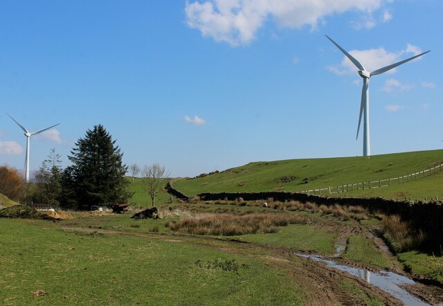
The hill is covered in a patchwork of vegetation, including grasses, heather, and scattered woodland areas. These provide habitats for various wildlife species, including birds, small mammals, and insects. The diverse flora and fauna make Bleasegale Hill an excellent spot for nature observation and photography.

A network of footpaths and trails crisscross the hill, allowing visitors to explore its scenic beauty at their own pace. The paths are well-maintained, making the ascent relatively easy for most walkers. Along the way, one can enjoy the tranquil atmosphere and immerse themselves in the natural surroundings.

Bleasegale Hill is also steeped in history, with ancient remains and artifacts discovered in the vicinity. Archaeological evidence suggests that the hill was inhabited during the Iron Age, and traces of ancient settlements and burial sites have been found in the area.

Overall, Bleasegale Hill offers a picturesque and rewarding experience for visitors, combining natural beauty, outdoor activities, and a glimpse into the region's rich history.

If you have any feedback on the listing, please let us know in the comments section below.

Bleasegale Hill Images

Images are sourced within 2km of 54.275328/-2.6659596 or Grid Reference SD5686. Thanks to Geograph Open Source API. All images are credited.

Old Milestone, B6254, near Crosslands Farm, Parish of Old Hutton and Holmescales The milestone is located 450m North of the farm on the grass embankment, on the East side of the road. Carved stone post, Kirkby Kendal stone design, erected by the Kendal, Kirkby Lonsdale, Milnthorpe turnpike trust in the 19th century.

Repainted by John Heap, John Shorrock and Arthur Robinson from Old Hutton & Holmescales Parish Council, August 2021. See  <a title="https://www.geograph.org.uk/photo/6864905" href="https://www.geograph.org.uk/photo/6864905">Link</a> taken before the repainting.

Inscription reads:- KIRKBY / LONSDALE / 6 : : KENDAL / 6
Carved benchmark and rivet on top.

Grade II listed. List Entry Number: 1087299 <span class="nowrap"><a title="https://historicengland.org.uk/listing/the-list/list-entry/1087299" rel="nofollow ugc noopener" href="https://historicengland.org.uk/listing/the-list/list-entry/1087299">Link</a><img style="margin-left:2px;" alt="External link" title="External link - shift click to open in new window" src="https://s1.geograph.org.uk/img/external.png" width="10" height="10"/></span>

Milestone Society National ID: WE_KLKDa06
Old Milestone, B6254, near Crosslands Farm, Parish of Old Hutton and Holmescales
The milestone is located 450m North of the farm on the grass embankment, on the East side of the road. Carved stone post, Kirkby Kendal stone design, erected by the Kendal, Kirkby Lonsdale, Milnthorpe turnpike trust in the 19th century. Repainted by John Heap, John Shorrock and Arthur Robinson from Old Hutton & Holmescales Parish Council, August 2021. See Link taken before the repainting. Inscription reads:- KIRKBY / LONSDALE / 6 : : KENDAL / 6 Carved benchmark and rivet on top. Grade II listed. List Entry Number: 1087299 LinkExternal link Milestone Society National ID: WE_KLKDa06
Old Milestone, B6254, Old Hutton, Parish of Old Hutton and Holmescales The milestone is located 50m West of the turn for Bendrigg Lodge, opposite Hutton Yeat, against the wall, on the East side of road. Carved stone post, Kirkby Kendal stone design, erected by the Kendal, Kirkby Lonsdale, Milnthorpe turnpike trust in the 19th century.

Repainted by John Heap, John Shorrock and Arthur Robinson from Old Hutton & Holmescales Parish Council, August 2021. See  <a title="https://www.geograph.org.uk/photo/6864922" href="https://www.geograph.org.uk/photo/6864922">Link</a> taken before the repainting.

Inscription reads:- KIRKBY / LONSDALE / 7 : : KENDAL / 5 
carved benchmark on top

Grade II listed. List Entry Number: 1335733 <span class="nowrap"><a title="https://historicengland.org.uk/listing/the-list/list-entry/1335733" rel="nofollow ugc noopener" href="https://historicengland.org.uk/listing/the-list/list-entry/1335733">Link</a><img style="margin-left:2px;" alt="External link" title="External link - shift click to open in new window" src="https://s1.geograph.org.uk/img/external.png" width="10" height="10"/></span>

Milestone Society National ID: WE_KLKDa07
Old Milestone, B6254, Old Hutton, Parish of Old Hutton and Holmescales
The milestone is located 50m West of the turn for Bendrigg Lodge, opposite Hutton Yeat, against the wall, on the East side of road. Carved stone post, Kirkby Kendal stone design, erected by the Kendal, Kirkby Lonsdale, Milnthorpe turnpike trust in the 19th century. Repainted by John Heap, John Shorrock and Arthur Robinson from Old Hutton & Holmescales Parish Council, August 2021. See Link taken before the repainting. Inscription reads:- KIRKBY / LONSDALE / 7 : : KENDAL / 5 carved benchmark on top Grade II listed. List Entry Number: 1335733 LinkExternal link Milestone Society National ID: WE_KLKDa07
Old Boundary Marker on the B6254 over Fall Beck Parish Boundary Marker against the eastern parapet of the bridge over Fall Beck on the B6284 south of the junction to Crosslands Farm. On the boundary of Old Hutton and Homescales and Preston Patrick parishes, inscribed OLD / HUTTON on its left face and PRESTON / PATRICK on its right face. Grade II Listed details <span class="nowrap"><a title="https://historicengland.org.uk/listing/the-list/list-entry/1335738" rel="nofollow ugc noopener" href="https://historicengland.org.uk/listing/the-list/list-entry/1335738">Link</a><img style="margin-left:2px;" alt="External link" title="External link - shift click to open in new window" src="https://s1.geograph.org.uk/img/external.png" width="10" height="10"/></span>. Re-painted in August 2021 by John Heap, John Shorrock and Arthur Robinson from Old Hutton and Holmescales Parish Council. See also <a title="https://www.geograph.org.uk/photo/6042537," href="https://www.geograph.org.uk/photo/6042537,">Link</a> <a title="https://www.geograph.org.uk/photo/6864918" href="https://www.geograph.org.uk/photo/6864918">Link</a> and <span class="nowrap"><a title="http://www.geog.port.ac.uk/webmap/thelakes/photos/bpw38.jpg" rel="nofollow ugc noopener" href="http://www.geog.port.ac.uk/webmap/thelakes/photos/bpw38.jpg">Link</a><img style="margin-left:2px;" alt="External link" title="External link - shift click to open in new window" src="https://s1.geograph.org.uk/img/external.png" width="10" height="10"/></span>.

Milestone Society National ID: WE_KLKDa05pb
Old Boundary Marker on the B6254 over Fall Beck
Parish Boundary Marker against the eastern parapet of the bridge over Fall Beck on the B6284 south of the junction to Crosslands Farm. On the boundary of Old Hutton and Homescales and Preston Patrick parishes, inscribed OLD / HUTTON on its left face and PRESTON / PATRICK on its right face. Grade II Listed details LinkExternal link. Re-painted in August 2021 by John Heap, John Shorrock and Arthur Robinson from Old Hutton and Holmescales Parish Council. See also Link Link and LinkExternal link. Milestone Society National ID: WE_KLKDa05pb
Bridge over M6 northbound
M6 near Beasegale Hill
M6 northbound near Old Hutton
Adverse Driving Conditions on the M6 Visibility has been reduced by mist and rain.
Adverse Driving Conditions on the M6
Visibility has been reduced by mist and rain.
Bridge  - M6 northbound
Bridge - M6 northbound
Bridge  - M6 northbound
Bridge - M6 northbound
On the Bridleway between Gillsmere Nook and Crosslands Farm The bridleway runs from Crosslands Farm on the B6254 over high pasture and through the scattered turbines of Armistead Wind Farm to reach a minor road on Gillsmere Nook
On the Bridleway between Gillsmere Nook and Crosslands Farm
The bridleway runs from Crosslands Farm on the B6254 over high pasture and through the scattered turbines of Armistead Wind Farm to reach a minor road on Gillsmere Nook
Munitions Store near Armistead Wind Farm I had no idea what this ugly structure was, until I saw Michael Graham's earlier submission.  The concrete bunker is surrounded by an area of fly tipping and ancillary furnishings.
Munitions Store near Armistead Wind Farm
I had no idea what this ugly structure was, until I saw Michael Graham's earlier submission. The concrete bunker is surrounded by an area of fly tipping and ancillary furnishings.
Return to Crosslands Farm Not the first time I have done this.  Thought this would take a good geograph, without realising I had already taken it.
It differs from the first one, being taken earlier in the year.
<a href="https://www.geograph.org.uk/photo/4531099">SD5786 : Crosslands Farm</a>
Return to Crosslands Farm
Not the first time I have done this. Thought this would take a good geograph, without realising I had already taken it. It differs from the first one, being taken earlier in the year. SD5786 : Crosslands Farm
Farm Track between Sill Field Farm and Crosslands Farm Public footpath between Sill Field Farm and the lane slightly to the west of Crosslands Farm - it bursts into open pasture, after being constrained between hedgerow and wall.
Farm Track between Sill Field Farm and Crosslands Farm
Public footpath between Sill Field Farm and the lane slightly to the west of Crosslands Farm - it bursts into open pasture, after being constrained between hedgerow and wall.
Watery Lane Track leading to Sillfield Out Barn, that looks almost abandoned and overtaken by nature.
Watery Lane
Track leading to Sillfield Out Barn, that looks almost abandoned and overtaken by nature.
Track descending towards Sill Field Farm Adopted by a public footpath from the lane, slightly to the west of Crosslands Farm.  Wonderful views are obtained from this vantage point, particularly to the south west - although a misty haze robs the landscape of clarity.
Track descending towards Sill Field Farm
Adopted by a public footpath from the lane, slightly to the west of Crosslands Farm. Wonderful views are obtained from this vantage point, particularly to the south west - although a misty haze robs the landscape of clarity.
Lane heading West towards Gatebeck
West View Well named - the dwelling occupies a position that offers wide sweeping views to the west
West View
Well named - the dwelling occupies a position that offers wide sweeping views to the west
Track beside Barkhouse Beck
Show me another place!

Bleasegale Hill is located at Grid Ref: SD5686 (Lat: 54.275328, Lng: -2.6659596)

Administrative County: Cumbria

District: South Lakeland

Police Authority: Cumbria

What 3 Words

///ushering.slides.divisions. Near Kendal, Cumbria

Related Wikis

Fellside Wood

Fellside Wood is a woodland in Cumbria, England, near the village of Old Hutton. It covers a total area of 5.46 hectares (13.5 acres). It is owned and...

Brunthwaite

Brunthwaite is a hamlet in Cumbria, England. Medieval pottery has been unearthed in the area. == References ==
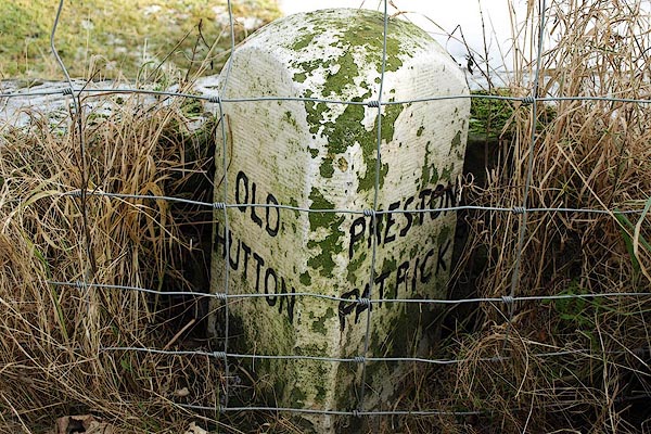
Old Hutton

Old Hutton is a village in South Lakeland, Cumbria, England. It is in the civil parish of Old Hutton and Holmescales In the 2001 census the parish had...

Middleshaw, Cumbria

Middleshaw is a hamlet on the B6254 road, near the village of Old Hutton, in the civil parish of Old Hutton and Holmescales, in the South Lakeland district...

Nearby Amenities

Located within 500m of 54.275328,-2.6659596
Location Transition: yes
Material: wood
Power: pole
Lat/Long: 54.2747583/-2.6728025
Material: wood
Power: pole
Lat/Long: 54.2755288/-2.6720166
Material: wood
Power: pole
Lat/Long: 54.2763964/-2.6711261
Material: wood
Power: pole
Lat/Long: 54.2771481/-2.6695517
Material: wood
Power: pole
Lat/Long: 54.2779014/-2.6679531
Material: wood
Power: pole
Lat/Long: 54.2786546/-2.6663357
Power: pole
Lat/Long: 54.279079/-2.6654077
Power: pole
Lat/Long: 54.2795441/-2.6644662
Man Made: tower
Tower Construction: lattice
Tower Type: communication
Lat/Long: 54.2753026/-2.6659913
Power: pole
Lat/Long: 54.2752385/-2.6629673
Power: pole
Lat/Long: 54.275841/-2.6635449
Power: pole
Lat/Long: 54.2764373/-2.6641541
Power: pole
Lat/Long: 54.2775455/-2.6652457
Man Made: street_cabinet
Lat/Long: 54.2765193/-2.672474
Power: pole
Lat/Long: 54.2727823/-2.6614369
Power: pole
Lat/Long: 54.2718506/-2.6615718
Power: pole
Lat/Long: 54.2719733/-2.661062
Bleasegale Hill
Natural: peak
Lat/Long: 54.2751414/-2.6661076
The data included in this document is from www.openstreetmap.org. The data is made available under ODbL.

Have you been to Bleasegale Hill?

Leave your review of Bleasegale Hill below (or comments, questions and feedback).