Cairny Hill

Hill, Mountain in Angus

Scotland

Cairny Hill

Cattle country, Tillydovie Livestock farm on the edge of the hill country.
Cattle country, Tillydovie Credit: Gordon Hatton

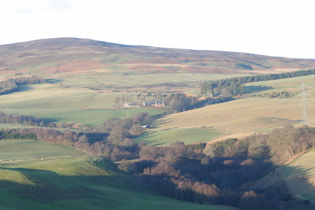
Cairny Hill is a prominent hill located in Angus, Scotland. Standing at an elevation of 228 meters (748 feet), it offers stunning panoramic views of the surrounding countryside and coastline. The hill is a popular destination for hikers and outdoor enthusiasts, with well-maintained trails leading to the summit.

Cairny Hill is known for its diverse flora and fauna, with heather-covered slopes and dense woodlands providing habitats for a variety of wildlife. Birdwatchers may spot a range of bird species, including buzzards and kestrels, soaring overhead.

At the summit of Cairny Hill, visitors can enjoy breathtaking views of the Angus countryside, with the towns of Montrose and Arbroath visible in the distance. On a clear day, it is even possible to see as far as the North Sea.

Overall, Cairny Hill offers a peaceful and scenic escape from the hustle and bustle of everyday life, making it a popular destination for nature lovers and those seeking a bit of tranquility in the great outdoors.

If you have any feedback on the listing, please let us know in the comments section below.

Cairny Hill Images

Images are sourced within 2km of 56.824786/-2.7314064 or Grid Reference NO5570. Thanks to Geograph Open Source API. All images are credited.

Cattle country, Tillydovie Livestock farm on the edge of the hill country.
Cattle country, Tillydovie
Livestock farm on the edge of the hill country.
Burn of Oldtown, West of Edzell The valley of the Burn of Oldtown runs across from left to right (North to South). With the exception of some rough pasture on the right the whole area is managed grouse moorland, with clear signs of regular heather burning and lines of grouse shooting butts.
Burn of Oldtown, West of Edzell
The valley of the Burn of Oldtown runs across from left to right (North to South). With the exception of some rough pasture on the right the whole area is managed grouse moorland, with clear signs of regular heather burning and lines of grouse shooting butts.
Black Hill, West of Edzell Black Hill (393m) on the right horizon, the Burn of Oldtown runs from left to right (North to South) in the valley. The area is managed grouse moorland with signs of regular burning of the heather to encourage new growth for the grouse to feed on
Black Hill, West of Edzell
Black Hill (393m) on the right horizon, the Burn of Oldtown runs from left to right (North to South) in the valley. The area is managed grouse moorland with signs of regular burning of the heather to encourage new growth for the grouse to feed on
Minor road near Witton Farm
Farmland at Margie
Farmland at Margie
Sheep near Witton Farm The Hill of Corathro on the skyline <a href="https://www.geograph.org.uk/gridref/NO5572">NO5572</a>.
Sheep near Witton Farm
The Hill of Corathro on the skyline NO5572.
Margie Farm
Margie Farm
Heading to Witton The road heading westwards towards Witton Farm in the woodland to the right.
Heading to Witton
The road heading westwards towards Witton Farm in the woodland to the right.
Oldtown from a distance The hillside farmstead of Oldtown, seen from the track to the west, with the Hill of Edzell beyond and the Hill of Garvock on the horizon.
Oldtown from a distance
The hillside farmstead of Oldtown, seen from the track to the west, with the Hill of Edzell beyond and the Hill of Garvock on the horizon.
Tin bothy Bothy on the slopes of the Hill of Formal.
Tin bothy
Bothy on the slopes of the Hill of Formal.
Track From Cowiehill to East Wirren Strathfinnella Hill in the centre distance
Track From Cowiehill to East Wirren
Strathfinnella Hill in the centre distance
Coire between Black Hill and Hill of Corathro
East Wirren From Hill of Corathro
Margie Farm, Glenlethnot, Edzell, looking across the Westwater from Lundie
Bogton Farmhouse Empty farmhouse with views south to Hill of Lundie.
Bogton Farmhouse
Empty farmhouse with views south to Hill of Lundie.
Farm buildings at Bogton Farm
Margie The Burn of Margie flows through the den in the foreground on its way to join the West Water. It is close to the Highland Boundary Fault and its name has been given to some of the geological units which mark the boundary, notably the Margie Limestone.
Margie
The Burn of Margie flows through the den in the foreground on its way to join the West Water. It is close to the Highland Boundary Fault and its name has been given to some of the geological units which mark the boundary, notably the Margie Limestone.
Show me another place!

Cairny Hill is located at Grid Ref: NO5570 (Lat: 56.824786, Lng: -2.7314064)

Unitary Authority: Angus

Police Authority: Tayside

What 3 Words

///novelists.popular.apes. Near Brechin, Angus

Nearby Locations

Cairny Hill

Related Wikis

Edzell Castle

Edzell Castle is a ruined 16th-century castle, with an early-17th-century walled garden. It is located close to Edzell, and is around 5 miles (8 km) north...

Caterthun

Caterthun, or the Caterthuns, is a ridge of hills near the city of Brechin in Angus, Scotland. The Caterthuns are notable for being the site of two Iron...

Edzell railway station

Edzell railway station served the village of Edzell, Angus, Scotland from 1896 to 1964 on the Brechin and Edzell District Railway. == History == The station...

Edzell

Edzell (; Scots: Aigle; Scottish Gaelic: Eigill) is a village in Angus, Scotland. It is 5 miles (8 km) north of Brechin, by the River North Esk. Edzell...

Nearby Amenities

Located within 500m of 56.824786,-2.7314064
Cairny Hill
Natural: hill
Place: locality
Lat/Long: 56.8260078/-2.7324031
The data included in this document is from www.openstreetmap.org. The data is made available under ODbL.

Have you been to Cairny Hill?

Leave your review of Cairny Hill below (or comments, questions and feedback).