Craig of Finnoch

Hill, Mountain in Angus

Scotland

Craig of Finnoch

Glen Lethnot One of the smaller Angus Glens running into rounded hills where many tracks lead up to grouse butts.
Glen Lethnot Credit: Gordon Hatton

Craig of Finnoch is a prominent hill located in the Angus region of Scotland. Sitting at an elevation of 1,291 feet (393 meters), it is recognized as one of the highest peaks in the area. This beautiful hill is part of the Grampian Mountains, known for their picturesque landscapes and breathtaking views.

Craig of Finnoch offers a variety of outdoor activities for nature enthusiasts and hikers. Its well-defined trails and paths make it accessible for both experienced climbers and beginners. The hill is particularly popular among locals and tourists who seek a challenging yet rewarding hiking experience.

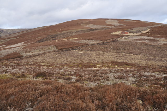
As visitors ascend Craig of Finnoch, they are treated to stunning panoramas of the surrounding countryside. The summit provides a 360-degree view, showcasing the rolling hills and valleys that define the Angus region. On clear days, it is even possible to catch a glimpse of the North Sea shimmering in the distance.

The hill is also home to a rich array of flora and fauna. Its slopes are covered with heather, grasses, and bracken, creating a vibrant and colorful landscape. Wildlife such as red deer, mountain hares, and birds of prey can often be spotted during the hike, adding an element of natural beauty and intrigue.

With its majestic height, diverse wildlife, and captivating vistas, Craig of Finnoch is a must-visit destination for those seeking an unforgettable outdoor experience in the Angus region of Scotland.

If you have any feedback on the listing, please let us know in the comments section below.

Craig of Finnoch Images

Images are sourced within 2km of 56.826063/-2.78157 or Grid Reference NO5270. Thanks to Geograph Open Source API. All images are credited.

Glen Lethnot One of the smaller Angus Glens running into rounded hills where many tracks lead up to grouse butts.
Glen Lethnot
One of the smaller Angus Glens running into rounded hills where many tracks lead up to grouse butts.
Woodland in Glen Lethnot Looking east across the West Water to woodland in Glen Lethnot.
Woodland in Glen Lethnot
Looking east across the West Water to woodland in Glen Lethnot.
Gully of the Burn of Freoch The wood fringed Burn of Freoch heading up the south-western flank of the Hill of Wirren from Glen Lethnot.
Gully of the Burn of Freoch
The wood fringed Burn of Freoch heading up the south-western flank of the Hill of Wirren from Glen Lethnot.
Road up Glen Lethnot Narrow minor road heading northwards up Glen Lethnot.
Road up Glen Lethnot
Narrow minor road heading northwards up Glen Lethnot.
Walled fields From the Glen Lethnot road looking across West Water valley to the walled fields
Walled fields
From the Glen Lethnot road looking across West Water valley to the walled fields
Burn of Oldtown, West of Edzell The valley of the Burn of Oldtown runs across from left to right (North to South). With the exception of some rough pasture on the right the whole area is managed grouse moorland, with clear signs of regular heather burning and lines of grouse shooting butts.
Burn of Oldtown, West of Edzell
The valley of the Burn of Oldtown runs across from left to right (North to South). With the exception of some rough pasture on the right the whole area is managed grouse moorland, with clear signs of regular heather burning and lines of grouse shooting butts.
Hill of Formal, West of Edzell Managed grouse moorland, with clear signs of irregular patches of heather burning. The area has frequent lines of grouse shooting butts.
Hill of Formal, West of Edzell
Managed grouse moorland, with clear signs of irregular patches of heather burning. The area has frequent lines of grouse shooting butts.
Torr na Menach, Northwest of Edzell Grouse moorland showing multiple stages of the effects of regular heather burning. Including recently burnt (dark at left centre) to fully grown (foreground and large areas on the hill), or at least as fully grown as it's ever going to attain given the burning, the altitude and the climate.
Torr na Menach, Northwest of Edzell
Grouse moorland showing multiple stages of the effects of regular heather burning. Including recently burnt (dark at left centre) to fully grown (foreground and large areas on the hill), or at least as fully grown as it's ever going to attain given the burning, the altitude and the climate.
Burn of Drumcairn, West of Edzell An area of managed grouse moorland, showing signs of regular heather burning. On the right of the image the burn can be seen to have produced a series of small interlocking spurs as it has eroded the valley.
Burn of Drumcairn, West of Edzell
An area of managed grouse moorland, showing signs of regular heather burning. On the right of the image the burn can be seen to have produced a series of small interlocking spurs as it has eroded the valley.
West Water, Glen Lethnot Land here is given over to grouse shooting, tick bearing deer are excluded.
West Water, Glen Lethnot
Land here is given over to grouse shooting, tick bearing deer are excluded.
Glen Lethnot Burn of Freoch descends from Hill of Wirren towards an unseen West Water.
Glen Lethnot
Burn of Freoch descends from Hill of Wirren towards an unseen West Water.
Finnoch The fields, and broken dykes remain of Finnoch, a ruined farm in Glen Lethnot.
Finnoch
The fields, and broken dykes remain of Finnoch, a ruined farm in Glen Lethnot.
Road up Glen Lethnot The unfenced road runs through rough grazing and moorland opposite Finnoch.
Road up Glen Lethnot
The unfenced road runs through rough grazing and moorland opposite Finnoch.
The road beside West Water
Across the West Water valley The Hill of Wirren is on the distant horizon.
Across the West Water valley
The Hill of Wirren is on the distant horizon.
Glen Lethnot The West Water flows down between the trees to Brigend.
Glen Lethnot
The West Water flows down between the trees to Brigend.
View towards the West Water A view to the south from West Wirren, with the course of the West Water visible (centre image) and forestry plantations on Nathro Hill beyond. West Wirren is a good vantage point, with Dundee Law and West Lomond Hill both visible - although almost obscured by haze in this image, which is a reverse view of  <a href="https://www.geograph.org.uk/photo/2054352">NO5071 : West Water</a>.
View towards the West Water
A view to the south from West Wirren, with the course of the West Water visible (centre image) and forestry plantations on Nathro Hill beyond. West Wirren is a good vantage point, with Dundee Law and West Lomond Hill both visible - although almost obscured by haze in this image, which is a reverse view of NO5071 : West Water.
Looking up Glen Lethnot The West Water in the floor of the Glen.
Looking up Glen Lethnot
The West Water in the floor of the Glen.
Show me another place!

Craig of Finnoch is located at Grid Ref: NO5270 (Lat: 56.826063, Lng: -2.78157)

Unitary Authority: Angus

Police Authority: Tayside

What 3 Words

///conqueror.shunted.cyber. Near Brechin, Angus

Nearby Locations

Craig of Finnoch

Related Wikis

Caterthun

Caterthun, or the Caterthuns, is a ridge of hills near the city of Brechin in Angus, Scotland. The Caterthuns are notable for being the site of two Iron...

Edzell Castle

Edzell Castle is a ruined 16th-century castle, with an early-17th-century walled garden. It is located close to Edzell, and is around 5 miles (8 km) north...

Menmuir

Menmuir is a parish in the county of Angus in Scotland. Kirkton of Menmuir consists of only three houses (the Old Schoolhouse, the Manse, the Old Inn)...

Edzell railway station

Edzell railway station served the village of Edzell, Angus, Scotland from 1896 to 1964 on the Brechin and Edzell District Railway. == History == The station...

Nearby Amenities

Located within 500m of 56.826063,-2.78157
The data included in this document is from www.openstreetmap.org. The data is made available under ODbL.

Have you been to Craig of Finnoch?

Leave your review of Craig of Finnoch below (or comments, questions and feedback).