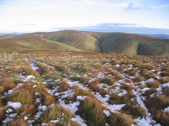
Cauldcleuch Head

Hill, Mountain in Roxburghshire

Scotland

Cauldcleuch Head

Looking down to the Billhope Burn The post marks a path through the native woodland on North Mid Hill. The path is very faint and the marker posts are intermittent.
Looking down to the Billhope Burn Credit: wrobison

Cauldcleuch Head is a prominent hill located in Roxburghshire, Scotland. Situated in the southern part of the country, it forms part of the scenic landscape of the Scottish Borders. With an elevation of approximately 535 meters (1,755 feet), it is considered a prominent hill rather than a mountain.

The hill is nestled within the sprawling Ettrick Forest, an area known for its natural beauty and rich history. Cauldcleuch Head offers breathtaking views of the surrounding countryside, including the rolling hills, vast moorlands, and meandering rivers that characterize the region.

The terrain of Cauldcleuch Head is mainly composed of heather-covered slopes, interspersed with patches of grassland and scattered rocky outcrops. The hill's summit provides a vantage point from which visitors can admire the picturesque vistas that stretch as far as the eye can see.

Cauldcleuch Head is a popular destination for hikers and outdoor enthusiasts, who are drawn to the area's tranquility and unspoiled wilderness. Several walking trails traverse the hill, offering varying levels of difficulty and opportunities to spot local wildlife, such as red deer and birds of prey.

The hill is also steeped in history, with ancient ruins and archaeological sites scattered throughout its vicinity. These remnants serve as a testament to the area's rich cultural heritage and provide a glimpse into the lives of those who once inhabited the region.

Overall, Cauldcleuch Head is a captivating natural landmark that showcases the rugged beauty and historical significance of Roxburghshire's landscape.

If you have any feedback on the listing, please let us know in the comments section below.

Cauldcleuch Head Images

Images are sourced within 2km of 55.297266/-2.85743 or Grid Reference NT4500. Thanks to Geograph Open Source API. All images are credited.

Looking down to the Billhope Burn The post marks a path through the native woodland on North Mid Hill. The path is very faint and the marker posts are intermittent.
Looking down to the Billhope Burn
The post marks a path through the native woodland on North Mid Hill. The path is very faint and the marker posts are intermittent.
Cauldcleuch Head summit from the south
Cauldcleuch Head Second Marilyn today after Greatmoor Hill with Chris Watson on a grey windy day.
Name: Cauldcleuch Head
Hill number: 1906
Height: 619m / 2031ft
Area: 28B: The River Tweed to the English Border
Class: Ma,G,D
Grid ref: NT 45655 00680
Summit feature:ground by fence post
Drop: 256m
Col: 363m  NT534016
Cauldcleuch Head
Second Marilyn today after Greatmoor Hill with Chris Watson on a grey windy day. Name: Cauldcleuch Head Hill number: 1906 Height: 619m / 2031ft Area: 28B: The River Tweed to the English Border Class: Ma,G,D Grid ref: NT 45655 00680 Summit feature:ground by fence post Drop: 256m Col: 363m NT534016
The Top Of Windy Edge A small gate of sorts at the top of Windy Edge as we near the summit of Cauldcleuch Head.
The Top Of Windy Edge
A small gate of sorts at the top of Windy Edge as we near the summit of Cauldcleuch Head.
Forest Ride Near Swire Knowe Looking towards a forest ride near Swire Knowe.  This is where the path from Braidlie, to the south, passes into the forest on its way to Priesthaugh.
Forest Ride Near Swire Knowe
Looking towards a forest ride near Swire Knowe. This is where the path from Braidlie, to the south, passes into the forest on its way to Priesthaugh.
Ascending Cauldcleuch Head Wet and rough
Ascending Cauldcleuch Head
Wet and rough
Above Langtae Syke Following the fence towards Langtae Hill
Above Langtae Syke
Following the fence towards Langtae Hill
Post, Footman Hass There is a wet vehicle track running along the fence but not much evidence of foot traffic on Footman Hass.
Post, Footman Hass
There is a wet vehicle track running along the fence but not much evidence of foot traffic on Footman Hass.
Gate, Footman Hass Looking towards Langtae Hill
Gate, Footman Hass
Looking towards Langtae Hill
Footman Hass From Langtae Hill
Footman Hass
From Langtae Hill
On Langtae Hill Looking towards the distinctive Skelfhill Pen
On Langtae Hill
Looking towards the distinctive Skelfhill Pen
Ascending Millstone Edge Looking towards the Roan Fell Hills
Ascending Millstone Edge
Looking towards the Roan Fell Hills
Langtae Hill
Langtae Hill
The upper Skelfhill valley
Boggy ground above Langtae Hill
Cauldcleugh Head
Cauldcleugh Head
On Footman Hass heading NE The rough quad bike track makes the walking a little easier.
On Footman Hass heading NE
The rough quad bike track makes the walking a little easier.
On Cauldcleuch Head summit - fence junction A rather wet summit.
On Cauldcleuch Head summit - fence junction
A rather wet summit.
Show me another place!

Cauldcleuch Head is located at Grid Ref: NT4500 (Lat: 55.297266, Lng: -2.85743)

Unitary Authority: The Scottish Borders

Police Authority: The Lothians and Scottish Borders

What 3 Words

///pigtails.massing.shaped. Near Teviothead, Scottish Borders

Related Wikis

Cauldcleuch Head

Cauldcleuch Head is a hill in an unnamed range of Roxburghshire hills north of Langholm, part of the Southern Uplands of Scotland. The highest hill in...

Maiden Paps (Hawick)

The Maiden Paps are twin hills near Hawick, in the Scottish Borders of the south east of Scotland, so named because they have the shape of human breasts...

Dinley

Dinley is a hamlet in the Scottish Borders through which Hermitage Water flows. == Etymology == The first element, din, seems to be the Cumbric word for...

Hermitage Castle

Hermitage Castle is a semi-ruined castle in the border region of Scotland. It is under the care of Historic Scotland. The castle has a reputation, both...

Nearby Amenities

Located within 500m of 55.297266,-2.85743
Cauldcleuch Head
Ele: 619
Natural: peak
Wikidata: Q24653258
Wikipedia: en:Cauldcleuch Head
Lat/Long: 55.2968271/-2.8576012
The data included in this document is from www.openstreetmap.org. The data is made available under ODbL.

Have you been to Cauldcleuch Head?

Leave your review of Cauldcleuch Head below (or comments, questions and feedback).