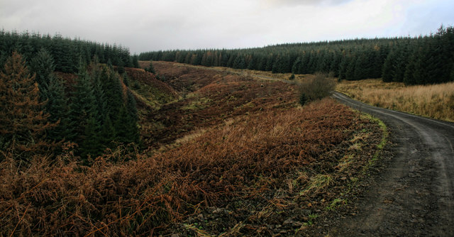
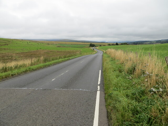
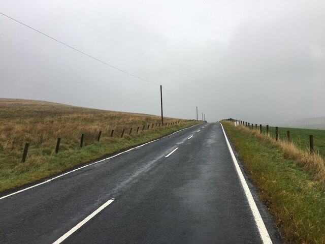
Track through the tree nursery
Kershopefoot had a NOFU (Newfoundland Overseas Forestry Unit) base camp ('District H') between 1939 and 1942. A shortfall in forestry labour was addressed by volunteers from Newfoundland with sites being established mainly in Scotland and northern England - see
Link
The Kershopefoot camp was located about 800 metres north east of this location at approximately NY477829. One source
Link notes: '..the nearby camp [which] began as a Ministry of Labour Civilian Instruction Centre. Unemployed men were sent there on various courses to help improve various skills including forestry work. A short stretch of the road was built by them north of Kershope Bridge. In later years the camp housed Army and forestry personnel, all using the nearby railway.'
The Scran database entry
Link has the following information under an image of the camp: 'View of military style camp with huts in ordered rows. The buildings have many windows and small gardens with trellis. In the distance, there is a very large flagpole. A railway line is visible in the background. Small woodland areas extending to moorland are in the distance. The G.I.C. [presumably C.I.C - Civilian Instruction Centre] Camp at Kershopefoot was established as a Base Camp for the Newfoundland Overseas Forestry Unit during World War II, when local workers were needed for the war effort. The nearby railway station had sidings and a tree nursery was established nearby. Around seventy such camps were established all over Scotland and the North East of England. Wages were low, with the men having to supply their own clothing but accommodation, transport and medical needs were supplied. They were all volunteers, sending home $1.00 a day to their families in Canada.'
Lastly, a remarkable account by Ken Jarvis in August 2004 as part of the BBC's WW2 People's War project (an archive of World War Two memories - written by the public, gathered by the BBC) at
Link details his experience as a 13 year old Boy Scout assisting with work at this tree nursery:
"My name is Ken Jarvis and I am 75 and living in Suffolk. I was born at Roby Old Hall near Liverpool in 1929. We moved to a suburb of Liverpool in 1939 just before the world war II broke out. After passing the 11+ exam I went to Grammar school in 1940 and joined the school Boy Scout Troup which is where my story begins. On leaving school I worked in Liverpool and later in Manchester. Retired in 1987 and moved to Essex to be nearer our (now grown up and married) two children. Further move to Suffolk earlier this year.
TIMBER!
It is the summer of 1941 and I am aged 13 and living in Liverpool where we have just suffered the devastating May blitz. I have just ended my second year in Grammar School and am a member of the school “Boy Scout” troup.
One of my schoolmasters is the Scout Leader and he decides that this year’s Scout Camp should be used to further the war effort and thereby gain for ourselves the “National Service” badge. He gets in touch with the Forestry Commission and offers our services. They say they would be delighted to have us and can find work for us at Kershope Forest a few miles across the border into Scotland.
With great excitement we picture ourselves as lumberjacks and hurriedly draw out all the felling axes from the Scout Storeroom making sure they are all honed and sharpened. Early one morning in mid August about 20 Boy Scouts assemble at Liverpool, Exchange Station for the train to Carlisle where we change to the Edinburgh “Waverley” line making arrangements with the guard for the train to make a special stop at Kershopefoot Halt our destination.
It is a long journey for us youngsters but in late afternoon the train pulls into a tiny wooden platform with a signal box at the end displaying the sign “Kershopefoot” We disembark and after a short move forward the rear guards van reaches the platform and we can remove all our kit (including three “bell” tents). Waiting for us was the official from the Forestry Commission who took us to a nearby field which was to be our “camp site” and told us we were to start work in the morning. The day was drawing to a close and there was frenzied activity to get the camp up and running before nightfall. We had little opportunity to look around but some concern was expressed amongst us for there was NOT A TREE IN SIGHT. We consoled ourselves with the thought that the forest was perhaps some miles away and we would be transported there on Monday morning. Feeling pretty exhausted we made supper and repaired to our patrol tent and our sleeping bags. We were right on the border between England and Scotland, in fact the level crossing at the station was considered to mark the boundary. We had arrived on Saturday and Sunday was a day off to get used to our surroundings. The nearest village was at Newcastleton which was about three miles away, we were told that if we wanted to go there we could go along the path beside the railway as all the locals did, but on no account to go anywhere near the railway track.
On Monday morning we prepared for work, but no sign of any transport. The Foreman told us that we would be walking to work but only about 250 yards. Across the level crossing and down a short path into a very large field, which had been set out in rows almost as far as the eye, could see. In this nursery field we were told 50,000 saplings of Canadian Spruce (a special gift from the Canadian Government) had been planted and our job for the fortnight was to remove every weed we could find from between the saplings. We worked in twos sitting on a long wooden bench that straddled the rows in the field. We left the piles of weeds at the end of the row to be picked up later by a small tractor which could drive across the field between the rows. The work was not hard but rather tedious but since we were working alongside the railway embankment we were able to relieve the boredom by doing a bit of “Train Spotting” The highlight of each day was the arrival of the Carlisle to Edinburgh express passing through at speed.
The felling equipment we had brought from Liverpool was not entirely wasted for on the middle Saturday we were all taken to Kilder [sic] Forest to do some lopping from the more established trees
The whole fortnight was an experience we will always remember and perhaps now the Border Forest Park is bringing pleasure to very many visitors without realising the wartime work of the Boy Scouts from Liverpool who helped to make it possible. We considered ourselves well rewarded by receiving the coveted National Service Badge!
gosfieldjarvis.
August 2004."
There still appears to be ongoing maintenance of the site by persons/organisation unknown, and there are small numbered marker stakes at the end of rows of trees. 1:10,000 scale mapping from 1957 labels the site as 'nursery' and does not indicate mature trees in this area by the Liddel Water. For greater appreciation of the tree nursery, one must look at an aerial image.
This photograph was taken during the Coronavirus (COVID-19) pandemic of 2020/21.


![Track through the tree nursery Kershopefoot had a NOFU (Newfoundland Overseas Forestry Unit) base camp (&#039;District H&#039;) between 1939 and 1942. A shortfall in forestry labour was addressed by volunteers from Newfoundland with sites being established mainly in Scotland and northern England - see <span class="nowrap"><a title="https://www.secretscotland.org.uk/index.php/Secrets/NewfoundlandOverseasForestryUnit" rel="nofollow ugc noopener" href="https://www.secretscotland.org.uk/index.php/Secrets/NewfoundlandOverseasForestryUnit">Link</a><img style="margin-left:2px;" alt="External link" title="External link - shift click to open in new window" src="https://s1.geograph.org.uk/img/external.png" width="10" height="10"/></span>
The Kershopefoot camp was located about 800 metres north east of this location at approximately NY477829. One source <span class="nowrap"><a title="https://www.nicholforestparish.co.uk/docs/waverley-line.pdf" rel="nofollow ugc noopener" href="https://www.nicholforestparish.co.uk/docs/waverley-line.pdf">Link</a><img style="margin-left:2px;" alt="External link" title="External link - shift click to open in new window" src="https://s1.geograph.org.uk/img/external.png" width="10" height="10"/></span> notes: &#039;..the nearby camp [which] began as a Ministry of Labour Civilian Instruction Centre. Unemployed men were sent there on various courses to help improve various skills including forestry work. A short stretch of the road was built by them north of Kershope Bridge. In later years the camp housed Army and forestry personnel, all using the nearby railway.&#039;
The Scran database entry <span class="nowrap"><a title="https://www.scran.ac.uk/database/record.php?usi=000-000-594-605-C&amp;scache=1dewn14rga&amp;searchdb=scran" rel="nofollow ugc noopener" href="https://www.scran.ac.uk/database/record.php?usi=000-000-594-605-C&amp;scache=1dewn14rga&amp;searchdb=scran">Link</a><img style="margin-left:2px;" alt="External link" title="External link - shift click to open in new window" src="https://s1.geograph.org.uk/img/external.png" width="10" height="10"/></span> has the following information under an image of the camp: &#039;View of military style camp with huts in ordered rows. The buildings have many windows and small gardens with trellis. In the distance, there is a very large flagpole. A railway line is visible in the background. Small woodland areas extending to moorland are in the distance. The G.I.C. [presumably C.I.C - Civilian Instruction Centre] Camp at Kershopefoot was established as a Base Camp for the Newfoundland Overseas Forestry Unit during World War II, when local workers were needed for the war effort. The nearby railway station had sidings and a tree nursery was established nearby. Around seventy such camps were established all over Scotland and the North East of England. Wages were low, with the men having to supply their own clothing but accommodation, transport and medical needs were supplied. They were all volunteers, sending home $1.00 a day to their families in Canada.&#039;
Lastly, a remarkable account by Ken Jarvis in August 2004 as part of the BBC&#039;s WW2 People&#039;s War project (an archive of World War Two memories - written by the public, gathered by the BBC) at <span class="nowrap"><a title="https://www.bbc.co.uk/history/ww2peopleswar/user/91/u824291.shtml" rel="nofollow ugc noopener" href="https://www.bbc.co.uk/history/ww2peopleswar/user/91/u824291.shtml">Link</a><img style="margin-left:2px;" alt="External link" title="External link - shift click to open in new window" src="https://s1.geograph.org.uk/img/external.png" width="10" height="10"/></span> details his experience as a 13 year old Boy Scout assisting with work at this tree nursery:
&quot;My name is Ken Jarvis and I am 75 and living in Suffolk. I was born at Roby Old Hall near Liverpool in 1929. We moved to a suburb of Liverpool in 1939 just before the world war II broke out. After passing the 11+ exam I went to Grammar school in 1940 and joined the school Boy Scout Troup which is where my story begins. On leaving school I worked in Liverpool and later in Manchester. Retired in 1987 and moved to Essex to be nearer our (now grown up and married) two children. Further move to Suffolk earlier this year.
TIMBER!
It is the summer of 1941 and I am aged 13 and living in Liverpool where we have just suffered the devastating May blitz. I have just ended my second year in Grammar School and am a member of the school “Boy Scout” troup.
One of my schoolmasters is the Scout Leader and he decides that this year’s Scout Camp should be used to further the war effort and thereby gain for ourselves the “National Service” badge. He gets in touch with the Forestry Commission and offers our services. They say they would be delighted to have us and can find work for us at Kershope Forest a few miles across the border into Scotland.
With great excitement we picture ourselves as lumberjacks and hurriedly draw out all the felling axes from the Scout Storeroom making sure they are all honed and sharpened. Early one morning in mid August about 20 Boy Scouts assemble at Liverpool, Exchange Station for the train to Carlisle where we change to the Edinburgh “Waverley” line making arrangements with the guard for the train to make a special stop at Kershopefoot Halt our destination.
It is a long journey for us youngsters but in late afternoon the train pulls into a tiny wooden platform with a signal box at the end displaying the sign “Kershopefoot” We disembark and after a short move forward the rear guards van reaches the platform and we can remove all our kit (including three “bell” tents). Waiting for us was the official from the Forestry Commission who took us to a nearby field which was to be our “camp site” and told us we were to start work in the morning. The day was drawing to a close and there was frenzied activity to get the camp up and running before nightfall. We had little opportunity to look around but some concern was expressed amongst us for there was NOT A TREE IN SIGHT. We consoled ourselves with the thought that the forest was perhaps some miles away and we would be transported there on Monday morning. Feeling pretty exhausted we made supper and repaired to our patrol tent and our sleeping bags. We were right on the border between England and Scotland, in fact the level crossing at the station was considered to mark the boundary. We had arrived on Saturday and Sunday was a day off to get used to our surroundings. The nearest village was at Newcastleton which was about three miles away, we were told that if we wanted to go there we could go along the path beside the railway as all the locals did, but on no account to go anywhere near the railway track.
On Monday morning we prepared for work, but no sign of any transport. The Foreman told us that we would be walking to work but only about 250 yards. Across the level crossing and down a short path into a very large field, which had been set out in rows almost as far as the eye, could see. In this nursery field we were told 50,000 saplings of Canadian Spruce (a special gift from the Canadian Government) had been planted and our job for the fortnight was to remove every weed we could find from between the saplings. We worked in twos sitting on a long wooden bench that straddled the rows in the field. We left the piles of weeds at the end of the row to be picked up later by a small tractor which could drive across the field between the rows. The work was not hard but rather tedious but since we were working alongside the railway embankment we were able to relieve the boredom by doing a bit of “Train Spotting” The highlight of each day was the arrival of the Carlisle to Edinburgh express passing through at speed.
The felling equipment we had brought from Liverpool was not entirely wasted for on the middle Saturday we were all taken to Kilder [sic] Forest to do some lopping from the more established trees
The whole fortnight was an experience we will always remember and perhaps now the Border Forest Park is bringing pleasure to very many visitors without realising the wartime work of the Boy Scouts from Liverpool who helped to make it possible. We considered ourselves well rewarded by receiving the coveted National Service Badge!
gosfieldjarvis.
August 2004.&quot;
There still appears to be ongoing maintenance of the site by persons/organisation unknown, and there are small numbered marker stakes at the end of rows of trees. 1:10,000 scale mapping from 1957 labels the site as &#039;nursery&#039; and does not indicate mature trees in this area by the Liddel Water. For greater appreciation of the tree nursery, one must look at an aerial image.
This photograph was taken during the Coronavirus (COVID-19) pandemic of 2020/21.](https://s3.geograph.org.uk/geophotos/06/78/41/6784123_e39546af.jpg)