Badadarrach

Hill, Mountain in Angus

Scotland

Badadarrach

Invermark Church, Glen Esk The church dates from 1803 and replaced a now ruined building that stands further west overlooking Loch Lee.
Invermark Church, Glen Esk Credit: Gordon Hatton

Badadarrach is a prominent hill located in the county of Angus, Scotland. It stands at an elevation of approximately 301 meters (988 feet) above sea level. The hill is part of the Grampian Mountains, which are known for their rich geological history and stunning landscapes.

Badadarrach is characterized by its distinct shape and rugged terrain. It features steep slopes covered with heather and grass, which create a picturesque view from its summit. The hill offers a challenging yet rewarding climb, attracting both experienced hikers and nature enthusiasts.

At the top of Badadarrach, visitors are rewarded with panoramic views of the surrounding countryside. On clear days, it is possible to see as far as the North Sea and the Cairngorms National Park to the west. The hill also provides an excellent vantage point to observe the local wildlife, including birds such as golden eagles and red grouse.

Badadarrach is situated in an area rich in history and cultural heritage. Nearby, there are ancient ruins and archaeological sites that shed light on the region's past. Visitors can explore these historical landmarks while enjoying the natural beauty of the landscape.

Overall, Badadarrach in Angus offers a great opportunity to immerse oneself in the beauty of the Scottish countryside. It combines scenic views, challenging hikes, and a glimpse into the area's history, making it a popular destination for outdoor enthusiasts and history buffs alike.

If you have any feedback on the listing, please let us know in the comments section below.

Badadarrach Images

Images are sourced within 2km of 56.928275/-2.9183021 or Grid Reference NO4482. Thanks to Geograph Open Source API. All images are credited.
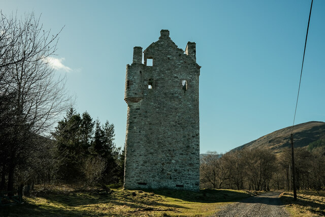
Invermark Church, Glen Esk The church dates from 1803 and replaced a now ruined building that stands further west overlooking Loch Lee.
Invermark Church, Glen Esk
The church dates from 1803 and replaced a now ruined building that stands further west overlooking Loch Lee.
Invermark Castle According to local estate information, the castle dates from 1526 and was built to help deter, or provide protection from caterans [Highland raiders], who were in the habit of coming over the mountains from Deeside and stealing cattle and anything else they could get their hands on. The only door is high on the south side [left, and out of sight in this view], whilst there are gun loops at the base of the tower in the 5ft thick walls.
Invermark Castle
According to local estate information, the castle dates from 1526 and was built to help deter, or provide protection from caterans [Highland raiders], who were in the habit of coming over the mountains from Deeside and stealing cattle and anything else they could get their hands on. The only door is high on the south side [left, and out of sight in this view], whilst there are gun loops at the base of the tower in the 5ft thick walls.
The 'front door' of Invermark Castle The only way into the castle is via this doorway, which retains its iron grille, and which is some 3m off the ground. Rather than have a ladder, it is thought that there was some form of drawbridge linked to an outbuilding which has now been demolished.
The 'front door' of Invermark Castle
The only way into the castle is via this doorway, which retains its iron grille, and which is some 3m off the ground. Rather than have a ladder, it is thought that there was some form of drawbridge linked to an outbuilding which has now been demolished.
Invermark shooting lodge [and Dobbin] A Victorian shooting lodge for those interested in grouse shooting, deer stalking or fishing. Apparently the building is available for rent, but then if you can afford the grouse shooting you can almost certainly afford the rental fee.
Invermark shooting lodge [and Dobbin]
A Victorian shooting lodge for those interested in grouse shooting, deer stalking or fishing. Apparently the building is available for rent, but then if you can afford the grouse shooting you can almost certainly afford the rental fee.
Water of Mark, Glen Mark
Invermark castle The castle at the top of Glen Esk
Invermark castle
The castle at the top of Glen Esk
Stuck tree Not quite sure how the tree made it under the bridge I'm standing on but I think it will take a bit of effort to remove.
Stuck tree
Not quite sure how the tree made it under the bridge I'm standing on but I think it will take a bit of effort to remove.
Lochlee Parish Church Lochlee Parish Church was built in 1803 to replace an earlier church, the remains of which stand at the east end of Lochlee. The 1803 church was said to have been built from stone taken from the outbuildings of Invermark Castle.
Lochlee Parish Church
Lochlee Parish Church was built in 1803 to replace an earlier church, the remains of which stand at the east end of Lochlee. The 1803 church was said to have been built from stone taken from the outbuildings of Invermark Castle.
Auchronie Taken from the carpark at the end of the public road up Glen Esk.
Auchronie
Taken from the carpark at the end of the public road up Glen Esk.
Flow metering station on the Water of Mark Before it joins the Water of Lee, in the background, to form the River North Esk.
Flow metering station on the Water of Mark
Before it joins the Water of Lee, in the background, to form the River North Esk.
Invermark Castle Beside the Water of Lee.
Remnants of snow cornices in the distance.
Invermark Castle
Beside the Water of Lee. Remnants of snow cornices in the distance.
Glen Mark Couternach is the dark mound breaking the skyline. The track, called The Mounth Road, continues up the glen to its right, past Mount Keen and into Glen Tanar.
Glen Mark
Couternach is the dark mound breaking the skyline. The track, called The Mounth Road, continues up the glen to its right, past Mount Keen and into Glen Tanar.
Bridge over the Burn of Branny
Lochlee Parish Church Church at the road end of Glen Esk.
Lochlee Parish Church
Church at the road end of Glen Esk.
Invermark Castle The remains of Invermark Castle at the end of Glen Esk.
Invermark Castle
The remains of Invermark Castle at the end of Glen Esk.
Water of Mark The Water of Mark in Glen Mark, seen from the track.
Water of Mark
The Water of Mark in Glen Mark, seen from the track.
Glen Mark Looking up Glen Mark along the track.
Glen Mark
Looking up Glen Mark along the track.
Glen Mark track The track in Glen Mark looking back down the glen towards Glen Esk.
Glen Mark track
The track in Glen Mark looking back down the glen towards Glen Esk.
Show me another place!

Badadarrach is located at Grid Ref: NO4482 (Lat: 56.928275, Lng: -2.9183021)

Unitary Authority: Angus

Police Authority: Tayside

What 3 Words

///trendy.mountains.physical. Near Ballater, Aberdeenshire

Nearby Locations

Badadarrach

Related Wikis

Invermark Lodge

Invermark Lodge is a hunting lodge which was built near Invermark Castle in 1852 for John Ramsay, 13th Earl of Dalhousie. It is now a listed building...

Invermark Castle

Invermark Castle is an oblong tower house dating from the 16th century, at the east of Loch Lee, Angus, Scotland. It is near the head of Glen Esk. ��2...

Glen Mark

Glen Mark is a glen in northern Angus, eastern Scotland, through which the Water of Mark flows. Near the mouth of the glen, at Auchronie, the Water of...

Loch Lee

National grid reference NO431800 Loch Lee is a loch in Angus, Scotland south of the Grampian Mountains that is fed by the Water of Lee and the Water of...

Mount Keen

Mount Keen (Scottish Gaelic: Monadh Caoin) is a 939-metre-high (3,081 ft) mountain in Scotland and the most easterly Munro. It can be accessed from several...

Tarfside

Tarfside is a small hamlet in Angus, Scotland. It is situated in Glen Esk, on the upper course of the River North Esk, around 8 miles north of Edzell,...

Falls of Unich

Falls of Unich is a waterfall of Scotland. == See also == Waterfalls of Scotland == References == Media related to Falls of Unich at Wikimedia Commons

Falls of Damff

Falls of Damff is a waterfall in Cairngorms National Park in Scotland. == See also == Waterfalls of Scotland == References ==

Nearby Amenities

Located within 500m of 56.928275,-2.9183021
Badadarrach
Alt Name En: Badadarroch
Ele: 525
Name Gd: Badaidh Darach
Natural: peak
Lat/Long: 56.9294604/-2.9181636
Waterway: weir
Lat/Long: 56.929231/-2.9103872
The data included in this document is from www.openstreetmap.org. The data is made available under ODbL.

Have you been to Badadarrach?

Leave your review of Badadarrach below (or comments, questions and feedback).