Calfhope Hill

Hill, Mountain in Midlothian

Scotland

Calfhope Hill

Summit, The Struther Rough ground, grazed by horses. They stayed lower down the hill as it was rather windy.
Summit, The Struther Credit: Richard Webb

Calfhope Hill is a prominent natural landmark located in Midlothian, Scotland. Rising to an elevation of 424 meters (1,391 feet), it is classified as a hill rather than a mountain. Situated in the southern part of the country, Calfhope Hill is part of the wider Moorfoot Hills range.

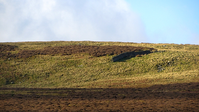
The hill is characterized by its distinctive rounded shape and is predominantly covered in heather and grass. It offers breathtaking views of the surrounding countryside, including the rolling hills and valleys that form the picturesque Scottish landscape. On clear days, it is possible to see as far as the Pentland Hills to the northwest, and the Southern Uplands to the south.

Calfhope Hill provides an excellent opportunity for outdoor enthusiasts to explore the area's natural beauty. Several walking and hiking trails traverse the hill, catering to various levels of difficulty and offering different perspectives of the scenery. These routes also provide an opportunity to appreciate the diverse wildlife that inhabits the region, including birds, small mammals, and plant species.

For those interested in history, Calfhope Hill holds significance as it was once part of the ancient Kingdom of Northumbria. The hill is also known for its archaeological remains, including Iron Age forts and Bronze Age settlements, which provide insights into the area's past.

Overall, Calfhope Hill offers a captivating outdoor experience, combining stunning panoramic views, diverse flora and fauna, and a rich historical background. Whether it be for a leisurely walk or a more challenging hike, visitors are sure to be mesmerized by the natural beauty that this Midlothian landmark has to offer.

If you have any feedback on the listing, please let us know in the comments section below.

Calfhope Hill Images

Images are sourced within 2km of 55.700231/-2.9527903 or Grid Reference NT4045. Thanks to Geograph Open Source API. All images are credited.

Summit, The Struther Rough ground, grazed by horses. They stayed lower down the hill as it was rather windy.
Summit, The Struther
Rough ground, grazed by horses. They stayed lower down the hill as it was rather windy.
Young hedge, Caddams Cleuch The shelterbelt was doing its work today, much more windy on the other side, on The Struther.
Young hedge, Caddams Cleuch
The shelterbelt was doing its work today, much more windy on the other side, on The Struther.
Newly planted hillside, Symington A block of young trees to the right of the shelter belt. View from The Struther.
Newly planted hillside, Symington
A block of young trees to the right of the shelter belt. View from The Struther.
Fountainhall from the air Shining Pool Wood is to the right and the wind farms at Hartside Hill and Dun Law can be seen in the distance. Viewed from a flight from Prague, heading for Edinburgh.
Fountainhall from the air
Shining Pool Wood is to the right and the wind farms at Hartside Hill and Dun Law can be seen in the distance. Viewed from a flight from Prague, heading for Edinburgh.
Isolated dyke section, Gately Rig A very short stretch of drystane dyking set amongst grouse moor and the odd bit of dun grassland.  In the Moorfoot Hills, Midlothian.
Isolated dyke section, Gately Rig
A very short stretch of drystane dyking set amongst grouse moor and the odd bit of dun grassland. In the Moorfoot Hills, Midlothian.
Over Shiels and the valley of Thrashie Burn With Saughly Law, an outlier of Deaf Heights on the other side.
Over Shiels and the valley of Thrashie Burn
With Saughly Law, an outlier of Deaf Heights on the other side.
Fernie Grain Sit Burn Deep in the Moorfoots, a typical Southern Upland scene, a steep sided V shaped valley amongst flat topped hills. The steep land, drains, and can give good grazing, the summits are often heavy bog land with deep deposits of peat.
Fernie Grain Sit Burn
Deep in the Moorfoots, a typical Southern Upland scene, a steep sided V shaped valley amongst flat topped hills. The steep land, drains, and can give good grazing, the summits are often heavy bog land with deep deposits of peat.
Track and Moorland Track on lower slopes of Mossy Rig, typical grouse moorland on the day before the glorious twelfth.
Track and Moorland
Track on lower slopes of Mossy Rig, typical grouse moorland on the day before the glorious twelfth.
Trap Difficult to see but there is a spring trap in the middle of the log, I was told for stoats and weasels. Someone at The British Association for Shooting and Conservation told me also that although not illegal it wouldn't be considered best practice.
Trap
Difficult to see but there is a spring trap in the middle of the log, I was told for stoats and weasels. Someone at The British Association for Shooting and Conservation told me also that although not illegal it wouldn't be considered best practice.
Track Looking towards Glenwhinnie Hill.
Track
Looking towards Glenwhinnie Hill.
Red Shed Sheep or hay shelter beside the Lugate Water which can be seen for miles because of the contrast with the greenery all round.
Red Shed
Sheep or hay shelter beside the Lugate Water which can be seen for miles because of the contrast with the greenery all round.
Moorland track A junction, with this branch heading towards butts on Mossy Rig. A longer branch heads downhill to the right and up towards Deaf Heights.
Moorland track
A junction, with this branch heading towards butts on Mossy Rig. A longer branch heads downhill to the right and up towards Deaf Heights.
Caddon Water The Caddon Water after a sharp turn in its course beneath Deaf Heights (right).  One of two circular fanks in the foreground.
Caddon Water
The Caddon Water after a sharp turn in its course beneath Deaf Heights (right). One of two circular fanks in the foreground.
Deaf Heights Moorland between the Caddon and Ewes Water. Typical Moorfoot grouse moor.
Deaf Heights
Moorland between the Caddon and Ewes Water. Typical Moorfoot grouse moor.
Cottage, Trously
Cottage, Trously
Grouse Butt No. 3, Trously
Track junction, Trously The track to Trously goes off to the left, whilst the one on the right follows the valley round to the right.
Track junction, Trously
The track to Trously goes off to the left, whilst the one on the right follows the valley round to the right.
Long Hangman Burn Drains part of Deaf Heights into the Lugate Water
Long Hangman Burn
Drains part of Deaf Heights into the Lugate Water
Show me another place!

Calfhope Hill is located at Grid Ref: NT4045 (Lat: 55.700231, Lng: -2.9527903)

Unitary Authority: The Scottish Borders

Police Authority: The Lothians and Scottish Borders

What 3 Words

///commands.starts.movements. Near Innerleithen, Scottish Borders

Nearby Locations

Calfhope Hill

Related Wikis

Windlestraw Law

Windlestraw Law is a hill in the Moorfoot Hills range, part of the Southern Uplands of Scotland. It is the highest peak of the range, and lies north of...

Allanshaugh

Allanshaugh is a fermtoun in the Scottish Borders area of Scotland. == See also == List of places in the Scottish Borders List of places in Scotland...

Fountainhall railway station

Fountainhall railway station served the village of Fountainhall, Scottish Borders from 1848 to 1969 on the Waverley Route. == History == The station opened...

Peatrig Hill

Peatrig Hill is a minor hill in Scotland, located about 15 km south-southeast of Edinburgh. One of the Moorfoot Hills, it is located in the parish of Heriot...

Nearby Amenities

Located within 500m of 55.700231,-2.9527903
The data included in this document is from www.openstreetmap.org. The data is made available under ODbL.

Have you been to Calfhope Hill?

Leave your review of Calfhope Hill below (or comments, questions and feedback).