Deaf Heights

Hill, Mountain in Midlothian

Scotland

Deaf Heights

Deaf Heights from the air Shining Pool Wood can be seen top, centre. Viewed from a flight from Prague, heading for Edinburgh.
Deaf Heights from the air Credit: Thomas Nugent

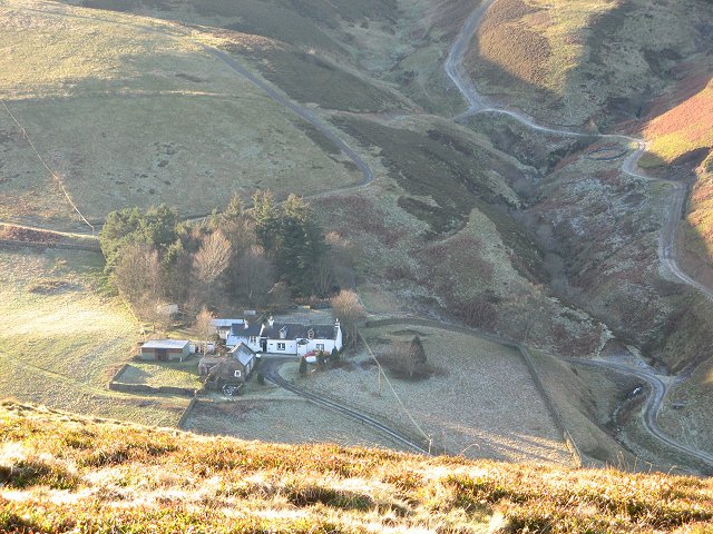
Deaf Heights, located in Midlothian, is a prominent hill/mountain that offers breathtaking views and serves as a popular destination for outdoor enthusiasts. Standing at an elevation of approximately 1,000 feet, it is one of the highest points in the area, providing a commanding vantage point to admire the surrounding landscape.

The hill/mountain is situated within a tranquil and picturesque countryside, characterized by rolling hills, lush greenery, and scattered woodlands. Its location offers a sense of seclusion and serenity, making it an ideal spot for hiking, nature walks, and picnics. The terrain is moderately challenging, but not overly strenuous, making it accessible to a wide range of visitors.

Deaf Heights boasts a diverse range of flora and fauna, with vibrant wildflowers and various species of birds and small mammals inhabiting the area. The hill/mountain is also home to a network of well-maintained trails, allowing visitors to explore its slopes and enjoy panoramic views of the surrounding Midlothian countryside.

The summit of Deaf Heights provides a breathtaking panorama, offering vistas that stretch for miles in all directions. On clear days, visitors can marvel at the rolling hills, meandering rivers, and distant towns that dot the landscape. The hill/mountain's height and location make it particularly popular for sunrise and sunset viewing, as the changing colors of the sky cast a magical glow over the surrounding scenery.

Overall, Deaf Heights in Midlothian is a natural gem that offers a peaceful escape and stunning vistas for nature lovers and outdoor enthusiasts alike.

If you have any feedback on the listing, please let us know in the comments section below.

Deaf Heights Images

Images are sourced within 2km of 55.690645/-2.9732367 or Grid Reference NT3844. Thanks to Geograph Open Source API. All images are credited.

Deaf Heights from the air Shining Pool Wood can be seen top, centre. Viewed from a flight from Prague, heading for Edinburgh.
Deaf Heights from the air
Shining Pool Wood can be seen top, centre. Viewed from a flight from Prague, heading for Edinburgh.
Deaf Heights from the air Shining Pool Wood can be seen near to the top centre of the photo. Viewed from a flight from Prague heading for Edinburgh.
Deaf Heights from the air
Shining Pool Wood can be seen near to the top centre of the photo. Viewed from a flight from Prague heading for Edinburgh.
Grouse grit Plastic trays like this have been set out at intervals of 2-300m on the heather moor; they contain grit for the red grouse, medicated to combat disease in the birds.
Grouse grit
Plastic trays like this have been set out at intervals of 2-300m on the heather moor; they contain grit for the red grouse, medicated to combat disease in the birds.
Fence angle near Pringles Green Occasional changes in fence direction provide the main excitement of the ridge walk to Windlestraw Law, along with sudden eruptions of red grouse or hares from amongst the heather.
Fence angle near Pringles Green
Occasional changes in fence direction provide the main excitement of the ridge walk to Windlestraw Law, along with sudden eruptions of red grouse or hares from amongst the heather.
The summit of Windlestraw Law The highest point in the Moorfoot hills, View is north East towards the Lammermuirs
The summit of Windlestraw Law
The highest point in the Moorfoot hills, View is north East towards the Lammermuirs
Fence angle, Pringle's Green A vague flat summit before the final ascent up Windlestraw Law.  The more shapely Eildon hills can be seen in the far distance.
Fence angle, Pringle's Green
A vague flat summit before the final ascent up Windlestraw Law. The more shapely Eildon hills can be seen in the far distance.
Track and Moorland Track on lower slopes of Mossy Rig, typical grouse moorland on the day before the glorious twelfth.
Track and Moorland
Track on lower slopes of Mossy Rig, typical grouse moorland on the day before the glorious twelfth.
Moorland Fence Summit of Deaf Heights looking towards Windlestraw Law, Scottish Borders
Moorland Fence
Summit of Deaf Heights looking towards Windlestraw Law, Scottish Borders
Trap Difficult to see but there is a spring trap in the middle of the log, I was told for stoats and weasels. Someone at The British Association for Shooting and Conservation told me also that although not illegal it wouldn't be considered best practice.
Trap
Difficult to see but there is a spring trap in the middle of the log, I was told for stoats and weasels. Someone at The British Association for Shooting and Conservation told me also that although not illegal it wouldn't be considered best practice.
Track Looking towards Glenwhinnie Hill.
Track
Looking towards Glenwhinnie Hill.
Birehope Rig A very broad (and wet) ridge. The heather predominates on the higher ground, but even the wet grassy area has patchy heather and a lot of grouse.
Birehope Rig
A very broad (and wet) ridge. The heather predominates on the higher ground, but even the wet grassy area has patchy heather and a lot of grouse.
Broomylees Rig Wet moorland but with a lot of heather amongst the grass. While open to sheep, they were mostly in the cleuchs with the better grass. Plenty of grouse though.
View towards Deaf Heights.
Broomylees Rig
Wet moorland but with a lot of heather amongst the grass. While open to sheep, they were mostly in the cleuchs with the better grass. Plenty of grouse though. View towards Deaf Heights.
Butts on Birehope Rig No doubt about to be used soon. Grouse were plentiful on this moor. 2007 was a notable year as unusually there were few complaints in the media about poor grouse numbers. Stating that it is going to be a bad season on air, is almost an annual ritual.
Butts on Birehope Rig
No doubt about to be used soon. Grouse were plentiful on this moor. 2007 was a notable year as unusually there were few complaints in the media about poor grouse numbers. Stating that it is going to be a bad season on air, is almost an annual ritual.
Birehope Rig Looking up Birehope Rig towards Windlestraw Law.
Birehope Rig
Looking up Birehope Rig towards Windlestraw Law.
Moorland track A junction, with this branch heading towards butts on Mossy Rig. A longer branch heads downhill to the right and up towards Deaf Heights.
Moorland track
A junction, with this branch heading towards butts on Mossy Rig. A longer branch heads downhill to the right and up towards Deaf Heights.
Caddon Water The Caddon Water after a sharp turn in its course beneath Deaf Heights (right).  One of two circular fanks in the foreground.
Caddon Water
The Caddon Water after a sharp turn in its course beneath Deaf Heights (right). One of two circular fanks in the foreground.
Deaf Heights Moorland between the Caddon and Ewes Water. Typical Moorfoot grouse moor.
Deaf Heights
Moorland between the Caddon and Ewes Water. Typical Moorfoot grouse moor.
Deaf Heights Steep moorland slopes falling towards the Caddon Water.
Deaf Heights
Steep moorland slopes falling towards the Caddon Water.
Show me another place!

Deaf Heights is located at Grid Ref: NT3844 (Lat: 55.690645, Lng: -2.9732367)

Unitary Authority: The Scottish Borders

Police Authority: The Lothians and Scottish Borders

What 3 Words

///unspoiled.dozed.homes. Near Innerleithen, Scottish Borders

Nearby Locations

Deaf Heights

Related Wikis

Windlestraw Law

Windlestraw Law is a hill in the Moorfoot Hills range, part of the Southern Uplands of Scotland. It is the highest peak of the range, and lies north of...

Peatrig Hill

Peatrig Hill is a minor hill in Scotland, located about 15 km south-southeast of Edinburgh. One of the Moorfoot Hills, it is located in the parish of Heriot...

Dewar, Scottish Borders

Dewar is a fermtoun by the Dewar Burn and Peatrig Hill, in the Scottish Borders area of Scotland. Places nearby include Allanshaugh, Borthwick Hall, Fountainhall...

Allanshaugh

Allanshaugh is a fermtoun in the Scottish Borders area of Scotland. == See also == List of places in the Scottish Borders List of places in Scotland...

Nearby Amenities

Located within 500m of 55.690645,-2.9732367
Ele: 560
Natural: peak
Lat/Long: 55.689566/-2.975394
Ele: 560
Natural: peak
Lat/Long: 55.6905336/-2.973334
The data included in this document is from www.openstreetmap.org. The data is made available under ODbL.

Have you been to Deaf Heights?

Leave your review of Deaf Heights below (or comments, questions and feedback).