Banwell

Settlement in Somerset

England

Banwell

Farm Buildings
Farm Buildings Credit: Adrian and Janet Quantock

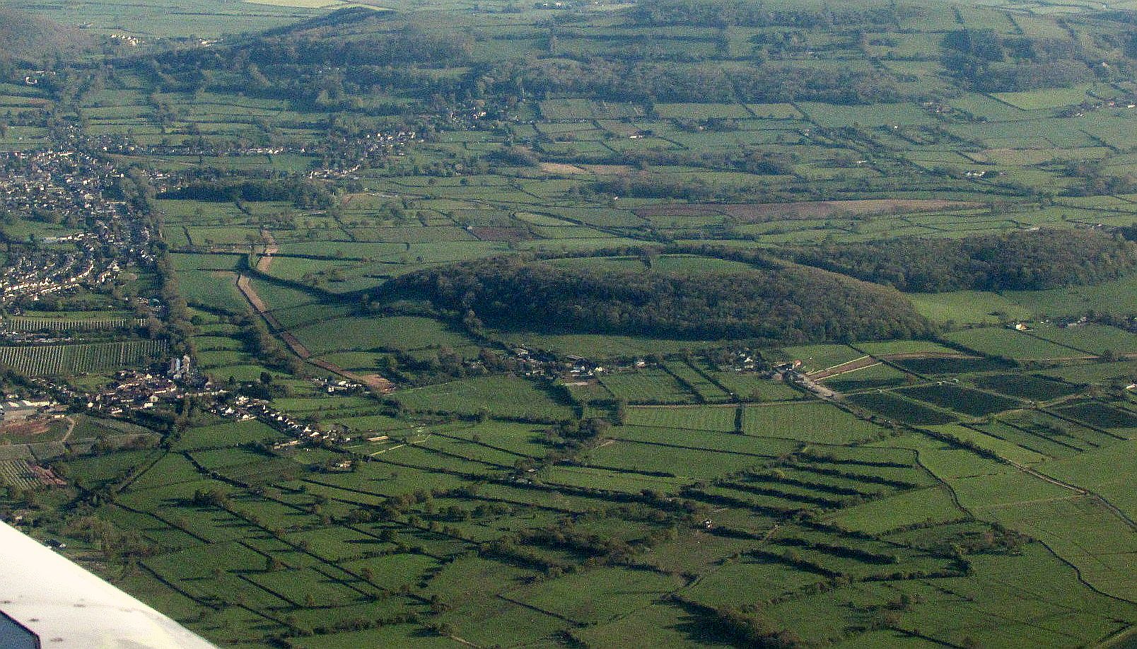
Banwell is a small village located in the county of Somerset, England. Situated on the western edge of the Mendip Hills, it lies approximately 5 miles southeast of Weston-super-Mare. With a population of around 2,000 residents, the village is known for its picturesque countryside and charming rural atmosphere.

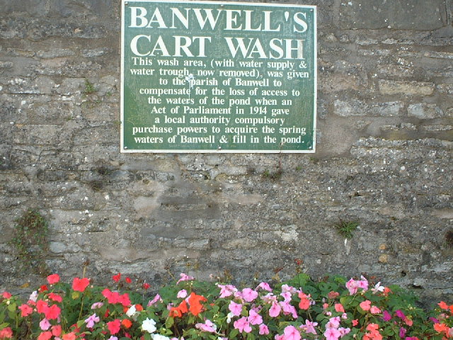
The origins of Banwell can be traced back to Roman times, as evidenced by the discovery of Roman coins and artifacts in the area. The village itself features a mix of architectural styles, including historic thatched cottages and more modern buildings. It is also home to the iconic Banwell Castle, a Grade II listed building renowned for its unique Gothic Revival design.

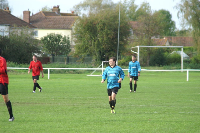
The community of Banwell is served by several amenities, including a primary school, village hall, and a number of local shops and businesses. The village also boasts a vibrant social scene, with various clubs and organizations catering to a range of interests, such as sports, crafts, and gardening.

Nature enthusiasts will find plenty to explore in Banwell, as the village is surrounded by beautiful countryside. The nearby Mendip Hills offer stunning walking and hiking trails, with panoramic views of the surrounding countryside and the Bristol Channel. Additionally, the famous Cheddar Gorge, known for its dramatic cliffs and limestone caves, is just a short drive away.

Overall, Banwell is a charming and idyllic village that offers a peaceful and picturesque setting, making it a desirable place to live for those seeking a rural lifestyle within easy reach of larger towns and cities.

If you have any feedback on the listing, please let us know in the comments section below.

Banwell Images

Images are sourced within 2km of 51.327333/-2.864127 or Grid Reference ST3959. Thanks to Geograph Open Source API. All images are credited.

Looking SSE from Winthill, near Banwell Looking South South East from Winthill, near Banwell and Weston-super-Mare. Brent Knoll is on the far right.
Looking SSE from Winthill, near Banwell
Looking South South East from Winthill, near Banwell and Weston-super-Mare. Brent Knoll is on the far right.
Sign in Banwell The site of Banwells former cart wash
Sign in Banwell
The site of Banwells former cart wash
Football Match Banwell Reserves 2 V Westside 4 (Blue Kit) At Banwell's Football Ground
Football Match
Banwell Reserves 2 V Westside 4 (Blue Kit) At Banwell's Football Ground
Banwell Village Bowling Green The green is built on the site of a pond that was filled in.
Banwell Village Bowling Green
The green is built on the site of a pond that was filled in.
Caves Banwell Bone Caves. See <span class="nowrap"><a title="http://en.wikipedia.org/wiki/Banwell_Caves" rel="nofollow ugc noopener" href="http://en.wikipedia.org/wiki/Banwell_Caves">Link</a><img style="margin-left:2px;" alt="External link" title="External link - shift click to open in new window" src="https://s1.geograph.org.uk/img/external.png" width="10" height="10"/></span>
Caves
Banwell Bone Caves. See LinkExternal link
Field View of fields from Yarberry Farm.
Field
View of fields from Yarberry Farm.
Fields Taken from Yarberry Farm
Fields
Taken from Yarberry Farm
Max Mill The water powered corn mill that once stood here was still powered by its overshot wheel in the 20th century. The mill was described by name in a document dated 1319.
Max Mill
The water powered corn mill that once stood here was still powered by its overshot wheel in the 20th century. The mill was described by name in a document dated 1319.
Banwell Castle Open to the public for Teas, great views towards Winscombe.
Banwell Castle
Open to the public for Teas, great views towards Winscombe.
Sandford Stone Centre Retail unit for stone & garden products.
Sandford Stone Centre
Retail unit for stone & garden products.
Cemetery on Ilex Lane Between the villages of Winscombe & Sandford. Consecrated in 1971.
Cemetery on Ilex Lane
Between the villages of Winscombe & Sandford. Consecrated in 1971.
Max Mill After heavy rains, a faster flow and brown water!
Max Mill
After heavy rains, a faster flow and brown water!
Summer Lane Near Banwell
Summer Lane
Near Banwell
View from Banwell Castle The view from the main bedroom in the keep at Banwell Castle
View from Banwell Castle
The view from the main bedroom in the keep at Banwell Castle
Banwell Castle Looking towards the castle from the castle grounds
Banwell Castle
Looking towards the castle from the castle grounds
Looking across Banwell Castle grounds Looking across the countryside away from Banwell Castle
Looking across Banwell Castle grounds
Looking across the countryside away from Banwell Castle
Banwell Hill Looking towards Banwell Hill across the fields with snow
Banwell Hill
Looking towards Banwell Hill across the fields with snow
Show me another place!

Banwell is located at Grid Ref: ST3959 (Lat: 51.327333, Lng: -2.864127)

Unitary Authority: North Somerset

Police Authority: Avon and Somerset

What 3 Words

///salaried.pocketed.springing. Near Banwell, Somerset

Nearby Locations

Banwell Stonebridge

Related Wikis

Banwell

Banwell is a village and civil parish on the River Banwell in the North Somerset district of Somerset, England. Its population was 3,251 according to the...

Banwell Castle

Banwell Castle is a Victorian Gothic Revival mansion in Banwell, Somerset, England. It is a Grade II* listed building. == History == The land on which...

Banwell Ochre Caves

Banwell Ochre Caves (grid reference ST407593) are a 12.46-hectare geological Site of Special Scientific Interest near the village of Banwell, North Somerset...

Banwell Camp

Banwell Camp is a univallate Iron Age hill fort in the North Somerset district of Somerset, England. The hill fort is situated approximately 1.6 miles...

Nearby Amenities

Located within 500m of 51.327333,-2.864127
Banwell
Is In: North Somerset, England, UK
Is In County: North Somerset
Place: village
Postal Code: BS29
Source: npe
Wikidata: Q2229524
Lat/Long: 51.3279764/-2.8629427
Barrier: stile
Lat/Long: 51.3306762/-2.8609268
Addr Housename: Appey Farm
Addr Street: Eastermead Lane
Source: GPS
Lat/Long: 51.3285075/-2.8594408
Fire Station
The Old Firestation
Note: disused
Lat/Long: 51.3275767/-2.8627346
Pub
The Brewers Arms
Wikidata: Q99593046
Lat/Long: 51.3288045/-2.8639395
Restaurant
Chillies Indian restaurant
Addr City: Banwell
Addr Housenumber: 26
Addr Postcode: BS29 6EA
Addr Street: Church Street
Cuisine: indian
Fhrs Id: 186121
Opening Hours: Mo, We, Th, Su 17:00-22:30; Fr, Sa 17:00-23:00
Source Addr: FHRS Open Data
Lat/Long: 51.3284398/-2.8639481
The Cart Wash
Tourism: attraction
Lat/Long: 51.328295/-2.8643257
Activity Toy Centre
Shop: yes
Lat/Long: 51.3281449/-2.8588926
Bus Stop
The Orchard
Naptan AtcoCode: 0190NSC30512
Naptan Bearing: E
Naptan CommonName: The Orchard
Naptan Crossing: Orchard Close
Naptan NaptanCode: wsmdmpd
Naptan Street: West Street
Naptan Verified: no
Source: naptan_import
Lat/Long: 51.3287866/-2.8675218
Bus Stop
The Orchard
Bus: yes
Naptan AtcoCode: 0190NSC30513
Naptan Bearing: W
Naptan CommonName: The Orchard
Naptan Crossing: Orchard Close
Naptan NaptanCode: wsmdmpm
Naptan Street: West Street
Naptan Verified: no
Public Transport: platform
Source: naptan_import
Lat/Long: 51.3285198/-2.8671149
Bus Stop
Dark Lane
Naptan AtcoCode: 0190NSC30514
Naptan Bearing: W
Naptan CommonName: Dark Lane
Naptan Crossing: Dark Lane
Naptan NaptanCode: wsmdmwp
Naptan Street: East Street
Naptan Verified: no
Source: naptan_import
Lat/Long: 51.3275262/-2.8623617
Bus Stop
Dark Lane
Naptan AtcoCode: 0190NSC30516
Naptan Bearing: E
Naptan BusStopType: CUS
Naptan CommonName: Dark Lane
Naptan Crossing: Dark Lane
Naptan NaptanCode: wsmdmwm
Naptan Street: East Street
Naptan Verified: no
Source: naptan_import
Lat/Long: 51.3276617/-2.8620153
Bus Stop
Banwell Castle
Naptan AtcoCode: 0190NSC30550
Naptan Bearing: NW
Naptan CommonName: Banwell Castle
Naptan NaptanCode: wsmdpap
Naptan Street: Castle Hill
Naptan Verified: no
Source: naptan_import
Lat/Long: 51.3241335/-2.8607702
Bus Stop
Banwell Castle
Naptan AtcoCode: 0190NSC30551
Naptan Bearing: SE
Naptan CommonName: Banwell Castle
Naptan NaptanCode: wsmdpat
Naptan Street: Castle Hill
Naptan Verified: no
Source: naptan_import
Lat/Long: 51.3242193/-2.860667
Post Office
Banwell
Addr Street: West Street
Source: OS_OpenData_StreetView
Lat/Long: 51.3282293/-2.8651087
Noexit: yes
Lat/Long: 51.3276175/-2.8664084
Turning Circle
Lat/Long: 51.3277957/-2.8692683
Recycling
Lat/Long: 51.3293478/-2.8668911
Post Box
Brand: Royal Mail
Brand Wikidata: Q638098
Mapillary: 1007160083694855
Operator: Royal Mail
Operator Wikidata: Q638098
Post Box Mounting: stone_wall
Post Box Type: wall
Survey Date: 2023-11-11
Lat/Long: 51.3290111/-2.8690418
Doctors
Lat/Long: 51.3282802/-2.8703841
Pharmacy
Lat/Long: 51.3281654/-2.8703405
Noexit: yes
Lat/Long: 51.3274833/-2.8664806
Noexit: yes
Lat/Long: 51.3283145/-2.8709879
Power: pole
Source: Bing
Lat/Long: 51.3311203/-2.865113
Design: h-frame
Power: pole
Source: Bing
Lat/Long: 51.3308044/-2.8643351
Power: pole
Source: Bing
Lat/Long: 51.3314656/-2.8659699
Crossing
Crossing: zebra
Source: Bing
Lat/Long: 51.3285266/-2.8666886
Bench
Source: Survey
Lat/Long: 51.3286877/-2.8669078
Telephone
Booth: KX100
Covered: booth
Mapillary: 132448982261075
Source: Survey
Survey Date: 2019-04-26
Lat/Long: 51.3286651/-2.8669052
Toilets
Source: Survey
Lat/Long: 51.3285385/-2.8663352
Library
Source: Survey
Lat/Long: 51.3284715/-2.8660428
Shop: butcher
Source: Survey
Lat/Long: 51.3282456/-2.8651717
Shop: newsagent
Source: Survey
Lat/Long: 51.3284321/-2.865839
Shop: convenience
Source: Survey
Lat/Long: 51.3284522/-2.8659382
Post Box
Source: Survey
Lat/Long: 51.3281991/-2.8651572
Power: pole
Source: Survey
Lat/Long: 51.3271626/-2.858967
Addr Street: Littlefields Road
Lat/Long: 51.3277396/-2.8689367
Addr Street: Littlefields Road
Lat/Long: 51.3278688/-2.8689726
Addr Street: Littlefields Road
Lat/Long: 51.3277919/-2.8691133
Addr Street: Littlefields Road
Lat/Long: 51.3277166/-2.8690831
Addr Street: Littlefields Road
Lat/Long: 51.3278149/-2.868967
Addr Street: Littlefields Road
Lat/Long: 51.3279555/-2.8690023
Addr Street: Littlefields Road
Lat/Long: 51.3278497/-2.8691155
Addr Street: Littlefields Road
Lat/Long: 51.3279363/-2.8691452
Addr Street: Littlefields Road
Lat/Long: 51.3275588/-2.8695096
Addr Street: Littlefields Road
Lat/Long: 51.3276781/-2.869408
Addr Street: Littlefields Road
Lat/Long: 51.3276433/-2.8695284
Addr Street: Littlefields Road
Lat/Long: 51.3275086/-2.8694996
Addr Street: Littlefields Road
Lat/Long: 51.3274136/-2.869479
Addr Street: Littlefields Road
Lat/Long: 51.3276555/-2.8693883
Addr Street: Littlefields Road
Lat/Long: 51.327661/-2.8695467
Addr Street: Littlefields Road
Lat/Long: 51.3274263/-2.8693287
Addr Street: Littlefields Road
Lat/Long: 51.327767/-2.8694362
Addr Street: Littlefields Road
Lat/Long: 51.3277499/-2.8695749
Addr Street: Littlefields Road
Lat/Long: 51.3275213/-2.8693493
Addr Street: Littlefields Road
Lat/Long: 51.3275709/-2.8693696
Defibrillator
Emergency: defibrillator
Lat/Long: 51.3284168/-2.8707616
Generator Method: photovoltaic
Generator Output Electricity: yes
Generator Source: solar
Generator Type: solar_photovoltaic_panel
Location: roof
Power: generator
Lat/Long: 51.3285368/-2.8684187
Generator Method: photovoltaic
Generator Output Electricity: yes
Generator Source: solar
Generator Type: solar_photovoltaic_panel
Location: roof
Power: generator
Lat/Long: 51.3285335/-2.8685394
Generator Method: photovoltaic
Generator Output Electricity: yes
Generator Source: solar
Generator Type: solar_photovoltaic_panel
Location: roof
Power: generator
Lat/Long: 51.3272278/-2.8711331
Generator Method: photovoltaic
Generator Output Electricity: yes
Generator Source: solar
Generator Type: solar_photovoltaic_panel
Location: roof
Power: generator
Lat/Long: 51.3270167/-2.8713021
Generator Method: photovoltaic
Generator Output Electricity: yes
Generator Source: solar
Generator Type: solar_photovoltaic_panel
Location: roof
Power: generator
Lat/Long: 51.326953/-2.8710634
Generator Method: photovoltaic
Generator Output Electricity: yes
Generator Source: solar
Generator Type: solar_photovoltaic_panel
Location: roof
Power: generator
Lat/Long: 51.3268843/-2.8707254
Generator Method: photovoltaic
Generator Output Electricity: yes
Generator Source: solar
Generator Type: solar_photovoltaic_panel
Location: roof
Power: generator
Lat/Long: 51.3268809/-2.8706047
Generator Method: photovoltaic
Generator Output Electricity: yes
Generator Source: solar
Generator Type: solar_photovoltaic_panel
Location: roof
Power: generator
Lat/Long: 51.3268792/-2.870476
Generator Method: photovoltaic
Generator Output Electricity: yes
Generator Source: solar
Generator Type: solar_photovoltaic_panel
Location: roof
Power: generator
Lat/Long: 51.327372/-2.8706476
Generator Method: photovoltaic
Generator Output Electricity: yes
Generator Source: solar
Generator Type: solar_photovoltaic_panel
Location: roof
Power: generator
Lat/Long: 51.327367/-2.8707147
Generator Method: photovoltaic
Generator Output Electricity: yes
Generator Source: solar
Generator Type: solar_photovoltaic_panel
Location: roof
Power: generator
Lat/Long: 51.327367/-2.8708112
Generator Method: photovoltaic
Generator Output Electricity: yes
Generator Source: solar
Generator Type: solar_photovoltaic_panel
Location: roof
Power: generator
Lat/Long: 51.3277072/-2.8711116
The data included in this document is from www.openstreetmap.org. The data is made available under ODbL.

Have you been to Banwell?

Leave your review of Banwell below (or comments, questions and feedback).