Auchnacraig Hill

Hill, Mountain in Aberdeenshire

Scotland

Auchnacraig Hill

Road Beside Linn of Muick View of the road running up Glen Muick from Ballater to Spittal of Muick.   The Linn of Muick waterfall is visible through the trees on the right.
Road Beside Linn of Muick Credit: Martin Addison

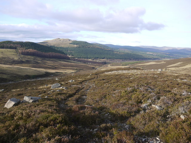
Auchnacraig Hill is a prominent hill located in Aberdeenshire, Scotland. Situated in the picturesque countryside, it forms part of the Grampian Mountains, which are known for their rugged beauty and stunning landscapes. The hill stands at an elevation of approximately 600 meters (1,969 feet) above sea level.

Auchnacraig Hill is characterized by its distinctive shape and rocky terrain. It is covered in heather and grass, providing a diverse habitat for various plant and animal species. The hill offers breathtaking panoramic views of the surrounding countryside, including the nearby towns and villages.

The hill is a popular destination for outdoor enthusiasts, including hikers and climbers, who are drawn to its challenging slopes and stunning vistas. There are several well-marked trails that lead to the summit, allowing visitors to explore the hill at their own pace. Along the way, hikers may encounter wildlife such as red deer, mountain hares, and various bird species.

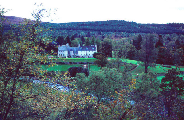
Auchnacraig Hill also holds historical significance, with evidence of ancient settlements and archaeological sites found in the vicinity. These remnants provide insight into the lives of the people who once inhabited the area.

Overall, Auchnacraig Hill is a natural wonder that offers visitors a chance to connect with nature, enjoy breathtaking views, and immerse themselves in the rich history of Aberdeenshire.

If you have any feedback on the listing, please let us know in the comments section below.

Auchnacraig Hill Images

Images are sourced within 2km of 56.991071/-3.0886094 or Grid Reference NO3389. Thanks to Geograph Open Source API. All images are credited.

Road Beside Linn of Muick View of the road running up Glen Muick from Ballater to Spittal of Muick.   The Linn of Muick waterfall is visible through the trees on the right.
Road Beside Linn of Muick
View of the road running up Glen Muick from Ballater to Spittal of Muick. The Linn of Muick waterfall is visible through the trees on the right.
Frosty morning in Glen Muick
The track down from Creag Dearg
Gate in the deer fence on the track to Creag Dearg And it's padlocked, so a climb necessary!
Gate in the deer fence on the track to Creag Dearg
And it's padlocked, so a climb necessary!
The track down from Creag Dearg
The track down from Creag Dearg This track IS there, but at times is pretty faint;  it appears now not to be well used by vehicles.
The track down from Creag Dearg
This track IS there, but at times is pretty faint; it appears now not to be well used by vehicles.
Red deer above the Allt Cholzie
Glen Muick View upstream, across the heathery hillside, to the Linn of Muick.
Glen Muick
View upstream, across the heathery hillside, to the Linn of Muick.
Allt an t-Sneachda The temperature had risen above freezing and the snow was starting to melt.
Allt an t-Sneachda
The temperature had risen above freezing and the snow was starting to melt.
Linn of Muick waterfall Salmon ladder on the right hand side of the falls to enable fish to get upstream
Linn of Muick waterfall
Salmon ladder on the right hand side of the falls to enable fish to get upstream
Track above Allt an t-Sneachda Going up Drum Cholzie to grouse butts.  Lochnagar in the distance.
Track above Allt an t-Sneachda
Going up Drum Cholzie to grouse butts. Lochnagar in the distance.
Estate bothy on Drum Cholzie A lunch hut in a sheltered spot NW of the summit.
Estate bothy on Drum Cholzie
A lunch hut in a sheltered spot NW of the summit.
Track on Drum Cholzie An estate track north of the summit.
Track on Drum Cholzie
An estate track north of the summit.
Ford, Allt an Uisge Looking towards Hunt Hill.
Ford, Allt an Uisge
Looking towards Hunt Hill.
Yet another locked gate in a deer fence Over I go, along with a party of four who happened to arrive at the same time. And sure as eggs is eggs, there was another one to climb, to exit the wood higher up.
Yet another locked gate in a deer fence
Over I go, along with a party of four who happened to arrive at the same time. And sure as eggs is eggs, there was another one to climb, to exit the wood higher up.
Bridge over a burn Carrying a minor road away from Spittal of Glenmuick, over the short (unnamed) combined flow of the Allt an Uisge and Allt an t-Sneachda down to the River Muick (off left).
Bridge over a burn
Carrying a minor road away from Spittal of Glenmuick, over the short (unnamed) combined flow of the Allt an Uisge and Allt an t-Sneachda down to the River Muick (off left).
Track to Aucholzie From minor road up Glen Muick.
Track to Aucholzie
From minor road up Glen Muick.
Linn of Muick Cottage By minor road up Glen Muick.
Linn of Muick Cottage
By minor road up Glen Muick.
Show me another place!

Auchnacraig Hill is located at Grid Ref: NO3389 (Lat: 56.991071, Lng: -3.0886094)

Unitary Authority: Aberdeenshire

Police Authority: North East

What 3 Words

///device.paintings.minute. Near Ballater, Aberdeenshire

Related Wikis

Linn of Muick

Linn of Muick is a waterfall on the river Muick, Aberdeenshire, Scotland. == See also == Waterfalls of Scotland Media related to Linn of Muick at Wikimedia...

Glenmuick

Glenmuick ( glen-MICK) is a glen and a former parish in Scotland. Places in the area include Birkhall, Culsh, Deecastle, Inchnabobart, and Spittal of Glenmuick...

Birkhall

Birkhall (from the Scots Birk Hauch: "Birch River-meadow") is a 210 km2 (52,000 acres) estate on Royal Deeside, Aberdeenshire, Scotland, owned by King...
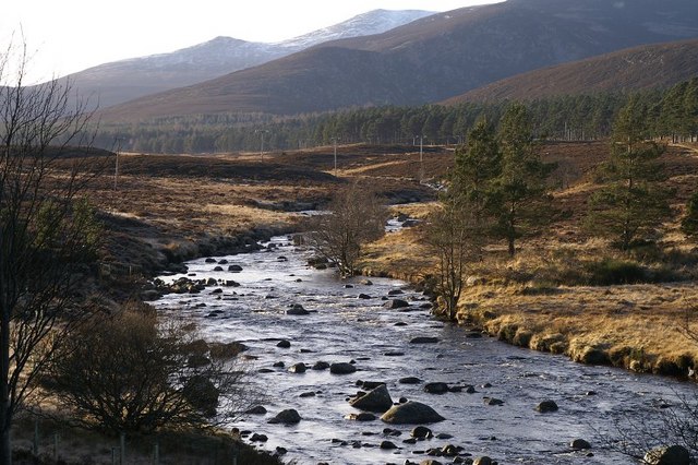
River Muick

River Muick () is a river of the Grampian Mountains of Aberdeenshire, Scotland. A tributary of the River Dee, it flows for about 6 kilometres (3.7 mi)...

Nearby Amenities

Located within 500m of 56.991071,-3.0886094
Auchnacraig Hill
Ele: 479
Natural: peak
Lat/Long: 56.9921376/-3.0892249
The data included in this document is from www.openstreetmap.org. The data is made available under ODbL.

Have you been to Auchnacraig Hill?

Leave your review of Auchnacraig Hill below (or comments, questions and feedback).